
1. Publication Draft North East Derbyshire Local Plan 2024 - 2044 (Reg 19)
Other elements in this consultation
7 Sustainable Development and Communities Comment
7.1 Introduction Comment
The Council will apply the presumption in favour of sustainable development in accordance with national planning policy. Sustainable development is not simply a matter of balancing economic, social and environmental objectives; it requires development to be planned and delivered in a way that responds to climate change, supports nature recovery, sustains heritage significance, protects public health and creates places that function well for existing and future communities.
The purpose of this chapter is to set out how development in North East Derbyshire will contribute to sustainable development, protect and enhance the natural and historic environment, respond to climate change, manage environmental risks and support well-designed, healthy and resilient communities.
The policies set out in this chapter should be considered in conjunction with the spatial strategy, the other policies in the Plan, and any relevant neighbourhood plan policies. Development proposals will be required to demonstrate how they have positively responded to national policy, statutory obligations, the Council’s evidence base, and the specific characteristics of both the site and its surrounding area.
7.2 Re-Use and Conversion of Buildings in the Green Belt and Countryside Comment
The re-use of existing buildings can support rural diversification, provide homes and employment opportunities, reduce the need for new buildings in the countryside and make efficient use of embodied resources. Consequently, as an exception to the restrictions on development in the Green Belt and the countryside the re-use, conversion or adaptation of agricultural and other rural buildings for new uses will be acceptable in principle provided that the criteria in Policy SDC1 are met.
Proposals involving the re-use and conversion of buildings within the Green Belt will also need to comply with Policy SS12. In all locations, development should conserve landscape character, protect biodiversity and avoid unacceptable impacts on amenity, highway safety, heritage assets and farm operations. Where protected or priority species may be present, proportionate ecological assessment will be required before determination. However, not all buildings in the Green Belt and countryside are suitable for conversion as they may be of insubstantial construction, of poor design or not in keeping with their surroundings. Proposals should demonstrate that the building is permanent, substantial and capable of conversion without major alterations, adaptations or re-construction, and that the proposed use would be appropriate to the site, its setting and wider surroundings. Structural surveys may be required in order to demonstrate that a building is structurally sound and capable of re-use. Where re-use is appropriate in principle, it is important to ensure that the resultant form, bulk and general design of the building is in keeping with its surroundings and the overall character and quality of the building is retained. The Council will prioritise the conversion of traditional buildings of historic or vernacular merit that contribute positively to local character. Modern utilitarian buildings (such as steel portal-framed or concrete-block structures) would not normally be suitable for conversion unless the proposal incorporates wholly exemplary design that complies with Policy SDC1 and is conclusively demonstrated to deliver a significant visual enhancement to the immediate landscape character. Proposals which involve rebuilding, rather than re-use, will be regarded as new development in the Green Belt or countryside, and will be considered against Policies SS1 and SS12 accordingly.
The conversion of buildings in rural areas to uses not originally intended in their design can result in visual intrusion, harm to the rural setting and/or increased traffic and activity with consequential adverse impacts on the countryside. The Council will seek to ensure that any proposal is appropriate for both the building itself and the area in which it is located. Proposed new uses should preserve the openness and character of the locality. Furthermore, the change of use of a rural building to a dwelling can cause substantial landscape harm through external domestic elements. The introduction of sprawling residential curtilages, manicured lawns, domestic boundary structures, close-boarded fencing, and outdoor domestic paraphernalia can severely degrade the open, rugged character of rural locations. Therefore, any approved domestic curtilage under Policy SDC1 must be strictly limited to the minimum area required for basic functional amenity space, utilising typical rural boundary treatments like native hedgerows, dry-stone walls, or post-and-rail fencing.
The re-use or conversion of agricultural or other rural buildings can result in the subsequent need for new buildings elsewhere on a landholding or inappropriate outside storage of materials, machinery and/or vehicles. In certain areas new rural buildings and outside storage can adversely affect the landscape and it may be appropriate to control their proliferation by using planning conditions including the removal of householder permitted development rights for extensions and outbuildings) or negotiating a planning obligation.
Many rural buildings can also be habitats for a variety of wildlife including bats and nesting birds, like barn owls. These species are sensitive to disturbance and therefore at risk from building works. They are also protected under separate legislation[25], with bats being afforded additional protection[26]. Therefore, an ecological survey will be required where species are protected by legislation or priority species listed under law[27] have the potential to be present.
Some agricultural buildings have permitted development rights to change into houses under Class Q. If an applicant submits a full planning application and argues that they could use these Class Q rights as a 'fallback position' (citing the Mansell v Tonbridge and Malling BC case), they must clearly prove there is a realistic chance they would actually build the Class Q version if this application is refused. Where the Council accepts that a realistic fallback option exists, the full planning application must deliver a significantly better architectural, environmental, and structural design than could be achieved through the basic Class Q route.
Policy SDC1: Re-use and Conversion of Buildings in the Green Belt and Countryside Comment
- Proposals for the re-use, conversion or adaptation of buildings in the Green Belt or countryside will be supported where they meet all of the following criteria:
- The building can be demonstrated* to be:
- of permanent and substantial construction and structurally sound; and
- capable of conversion, adaptation or reuse without major alterations (such as significant wall rebuilding, new foundation works or full re-construction) or substantial extensions;
- The building is a traditional building of historic or vernacular merit, or makes a positive contribution to the character and appearance of the landscape. The conversion of modern, purely functional, or utilitarian buildings (such as portal-framed or concrete-block structures) will not be permitted unless it is conclusively demonstrated that the development would result in a significant visual enhancement to the immediate setting;
- The proposed use, scale of activity, access arrangements and servicing would be appropriate to the location;
- The building’s form, bulk, design and materials is, or can be made to be, in keeping with the surrounding area;
- The design respects the positive architectural traditional character and historic interest of the original structure, and utilises matching local materials;
- The proposal would preserve the openness of the Green Belt, where relevant, and would not cause unacceptable harm to the character of the countryside and/or landscape;
- Any associated domestic curtilage or garden extension is strictly limited to the minimum area required to provide functional amenity space, is defined by appropriate rural boundary treatments, and does not encroach into or harm the openness and character of the surrounding countryside or Green Belt;
- The new use would not result in the subsequent need for replacement rural buildings or inappropriate outside storage of any materials, lighting, hardstanding, machinery and / or vehicles that would cause harm to the Green Belt and Countryside;
- Protected and priority species, including bats and nesting birds, are appropriately surveyed, protected and enhanced, and provision is made for nesting boxes and roosts, where appropriate; and
- As far as is reasonable and practicable, the development is accessible or can be made accessible by sustainable modes of transport.
- The building can be demonstrated* to be:
*Details to be provided in a structural survey prepared by a suitably qualified engineer.
7.3 Trees, Woodland, Hedgerows and other Irreplaceable Habitat Comment
Trees, woodland, orchards and hedgerows are key features which can define landscape character and contribute to the quality and enjoyment of the environment and place. They can have great nature conservation, amenity and recreational value, while also helping to reduce noise and atmospheric pollution and providing valuable ecosystem services. They are important components of local character, biodiversity, water management, carbon storage, shading, air quality and health and wellbeing. Ancient woodland, ancient and veteran trees, and other irreplaceable habitats are of particular importance and require strong protection.
The district contains areas of woodland including ancient woodland dating from at least the 1600’s (semi- natural and replanted), and a substantial number of scattered trees in rural and urban areas. Some of the most important concentrations of ancient semi-natural woodland are within the Moss Valley, which is designated as a SSSI, around Ogston Reservoir, and to the south of Holymoorside. Trees and woodlands take many years to mature, and so ancient woodlands, ancient and veteran trees, and wooded pasture and parkland are an irreplaceable resource. Development proposals that would result in the loss, or damage, to mature or ancient and veteran trees, or areas of mature or ancient woodland, or wooded pasture and parkland will not normally be permitted.
Other individual trees, tree groups and woodland can also be, and often are, protected by Tree Preservation Orders. Protection is also given if they are located in a Conservation Area. When necessary, the Council will use Tree Preservation Orders as a means of protection if their loss would be significant in landscape or visual amenity terms. In addition, the Hedgerow Regulations 1997 afford special protection to countryside hedgerows which are considered to be ‘important’ due to their age, and their archaeological, historical, landscape or wildlife significance.
Trees, woodlands and hedgerows are sensitive to the impacts of development, either directly through their removal or indirectly through the impacts of construction. Due to the positive contribution, they can make to the quality of development, they should always be considered at the outset of the design process, and retained and protected, wherever possible.
Development should be designed around existing trees, woodland and hedgerows from the outset. Where loss is unavoidable and acceptable, suitable replacement planting and long-term management will be required within the site, or in the locality where this is more appropriate. New planting should be well designed and appropriate to the context, choosing the right trees for the right location for the right reasons. Development can make a positive contribution to the local tree and hedgerow resource through new planting or the restoration and improved management of existing features. Planting schemes that are resilient to climate change, maximise the benefits to the local landscape, wildlife, and air quality through well designed green infrastructure will be preferred.
The many benefits provided by trees positively correlate with their size, and planting proposals need to ensure trees have access to the nutrients, oxygen and water they need to fulfil their genetic potential for growth and longevity. Tree planting proposals must provide adequate rooting volume to sustain trees to maturity. Modern load-bearing systems such as structural growing media, crate systems and raft systems may be necessary to provide sufficient rooting volume below ground in the hard landscape.
Newly planted trees often lack the spreading roots and non-structural carbohydrate reserves of established trees. As such, they are often vulnerable to drought, disturbance and damage in the short term until they have become established. Proposals that include the planting of landscape trees will need to provide a detailed programme of post planting maintenance, to include the irrigation, support and protection of trees over these years of vulnerability until they are independent within the landscape.
BS 5837:2012 provides the current industry standard for assessing and managing trees in the planning and development process. It promotes the retention of trees where possible and ensures that development is designed to avoid or minimise harm to trees and their root systems. Compliance with the Standard helps to secure development that successfully integrates existing green infrastructure and protects its environmental, social and economic benefits.
Policy SDC2: Trees, Woodland, Hedgerows & Other Irreplaceable Habitat Comment
- Development proposals should protect and, where practicable, integrate existing trees, woodland, orchards and hedgerows that have landscape, biodiversity, historic, carbon storage, water management or amenity value. Applications affecting such features should be informed by an assessment undertaken in accordance with BS 5837 or any successor document.
- Proposals for development should include appropriate landscaping plans, which incorporate suitable tree planting that integrates well with existing trees. Proposals shall provide 0.6m³ of soil for each m² of expected canopy projection at maturity for newly planted trees and shall include a program of post-planting maintenance to achieve independence in the landscape.
- Development that would result in the unacceptable loss of, deterioration of, or damage to, or which threatens the continued well-being of irreplaceable habitats, protected trees, hedgerows, orchards, ancient or veteran trees or woodland (including those not protected but considered worthy of protection), will not be permitted unless significant, exceptional reasons can be demonstrated, and appropriate compensation can be provided.
- Where trees, woodland or hedgerows will be lost to development and this is considered to be acceptable, suitable compensatory planting must take place at a ratio of at least 3:1. Where this level of tree planting is not achievable on site it may be appropriate to contribute to tree planting in the district through off-site developer contributions.
- Replacement planting should provide equivalent or greater biodiversity, landscape and climate resilience benefits.
- New planting should use species and varieties appropriate to the context, and this can include native or exotic species. New planting should be well-designed and should maximise the benefits to the local landscape, wildlife and air quality.
- Development proposals should incorporate appropriate buffers, root protection areas, construction safeguards and management measures, informed by an up-to-date arboricultural and ecological assessment where necessary.
7.4 Landscape Character Comment
The character of the District’s landscape is one of contrast and diversity. The western part of the district extends up to and into the edge of the Peak District National Park, and comprises a highly scenic landscape with rolling hills, river valleys, extensive woodland and small attractive villages, including some of the finest Derbyshire landscape outside the National Park. In contrast the eastern part of the district contains larger settlements and alongside evidence of their industrial past are large areas of attractive countryside where the landscape has its own distinctive local character.
The beauty and diversity are important both to the quality of life of local communities and the economic prosperity of the district as a whole often being a central factor in attracting business and tourism. National policy states that valued landscapes should be protected and enhanced[28]through policies in development plans.
The characteristics of the district’s landscape are assessed in detail in ‘The Landscape Character of Derbyshire’ which is supported by the ‘Derbyshire Historic Landscape Characterisation Study’. The assessment systematically classifies the landscape into distinctive areas based on the interaction between a range of factors including topography, geology, ecology, soils, land use and tree cover. The Derbyshire Landscape Character Area Assessment subdivides the district into 12 Landscape Character Types (LCT’s) over 4 National Character Areas (NCA’s) (see Table 8.1 & Figure 8.1).
A part of the far west of the district lies within the Peak District National Park which has its own separate landscape character assessment. If the special qualities of the National Park are to be protected, careful control needs to be exercised over development outside, but which may have a harmful impact upon it. Proposals should therefore take account of the adopted Peak District National Park Authority Landscape Strategy (2022-31) and will not be permitted when it is considered to be harmful to the valued characteristics of the National Park, or its statutory purposes namely to conserve and enhance its natural beauty, wildlife and cultural heritage, and to promote opportunities for the understanding and enjoyment of the special qualities of national parks by the public. Where proposals would result in conflict between the two purposes, the council will attach greater weight to the former.
Using the approach of Landscape Character Assessment, Derbyshire County Council has identified ‘Areas of Multiple Environmental Sensitivity’ (AMES) (Figure 8.2) based upon three key indicators - ecology, historical landscape and visual unity.
The Study identifies Areas of ‘Primary Sensitivity’[29], considered to be the most sensitive areas of landscape, and which are most likely to be negatively affected by change or development. In these areas, there will be a strong focus on the protection and conservation of their environmental assets. Areas of ‘Secondary Sensitivity’ are still considered to have environmental sensitivities but are potentially weaker in one area. In these areas, the focus will be on management (conservation and enhancement), maintaining those features of existing value but also addressing those in decline (e.g. through landscape restoration and habitat creation). In North East Derbyshire, the AMES study identifies the key areas of primary sensitivity in the Peak Fringe[30]. In addition, within this landscape context Derbyshire County Council has prepared a tranquillity map for Derbyshire[31]. This map which expresses locally the spread of tranquillity will be a material consideration when determining proposals under Policy SDC3.
For proposals where it is considered the development would be sensitive in the landscape the council will expect applicants to submit a Landscape and Visual Impact Assessment with planning applications; in order to demonstrate how the development would impact upon the local and wider landscape.
Table 7.1: Landscape Character Type
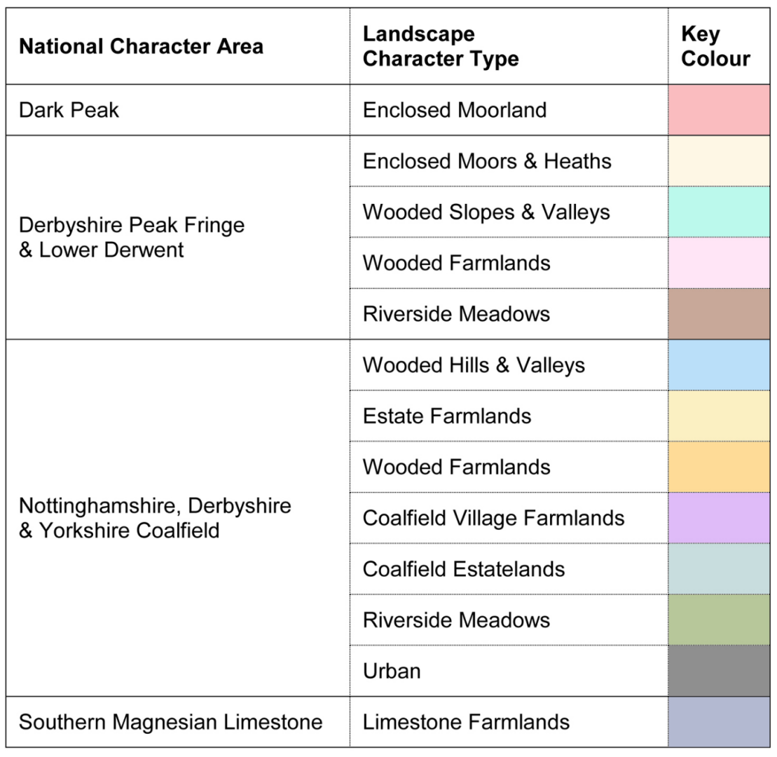
Figure 7.1: Landscape Character Map of Derbyshire
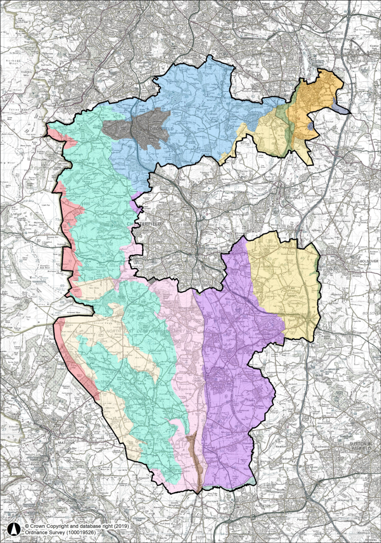
Figure 7.2: Areas of Multiple Environmental Sensitivity
Policy SDC3: Landscape Character Comment
- Proposals for new development will only be permitted where they would not cause significant harm to the character, quality, distinctiveness, tranquillity, or sensitivity of the landscape, or to important features, dark skies or valued views, or other perceptual qualities, either in isolation or cumulatively.
- Development proposals should be informed by, and be sympathetic to, the distinctive landscape areas identified in the most up-to-date Derbyshire Landscape Character Assessment and the Areas of Multiple Environmental Sensitivity (AMES), or any successor document(s), and contribute, where appropriate, to the conservation and enhancement, or restoration and re-creation of the local landscape taking into account its wider landscape character type.
- Development should where possible conserve, enhance or restore characteristic landscape features, including landform, field patterns, trees, hedgerows, woodland, watercourses, settlement edges, historic features and locally distinctive materials.
- Planning permission will not be granted for development outside the Peak District National Park which would damage or significantly affect the National Park purposes or its valued characteristics.
- A Landscape and Visual Impact Assessment, proportionate to the scale and sensitivity of the proposal, will be required where development may have significant landscape or visual effects.
7.5 Biodiversity and Geodiversity Comment
Biodiversity is defined as the variety and diversity of life-forms and the role that they play in the natural world. Biodiversity includes all species of plants and animals and the natural systems that support them. Geodiversity is the variety of rocks, minerals, fossils, landforms, sediments and soils, together with the natural processes which form and alter them.
The NPPF states that the planning system should contribute to and enhance the natural and local environment by:
- recognising the intrinsic character and beauty of the countryside, and the wider benefits from natural capital and ecosystem services; including the economic and other benefits of the best and most versatile agricultural land, and of trees and woodland; and
- minimising impacts on and providing net gains for biodiversity, including by establishing coherent ecological networks that are more resilient to current and future pressures and incorporating features which support priority or threatened species such as swifts, bats and hedgehogs.[32]
- The Plan area has a rich biodiversity which comprises a network of nationally, regionally, and locally designated sites important for their nature conservation and geodiversity value. It contains:
- 7 Sites of Special Scientific Interest (SSSI) - which are nationally recognised for their wildlife and geological interest;
- just over 200 Local Wildlife Sites (LWS) – which are the most important non-statutory wildlife sites in Derbyshire and cover a wide variety of habitats such as ancient woodland, grassland and wetlands - the value of which is recognised in the Lowland Derbyshire Biodiversity Action Plan. The Action Plan identifies the most important species and habitats in Derbyshire outside the Peak Park and is a key document to underpin the application of Policy SDC4.
- 5 Local Nature Reserves (LNR’s) – Williamthorpe Ponds on the edge of Holmewood, The Green at Wessington, Ashover Rock to the north east of Ashover, Highoredish off Coldharbour Lane, and Eddlestow Lot off Robridding Road – these have been declared for the benefit of both people and wildlife and offer convenient access for people to enjoy and learn about nature; and
- a number of Regionally Important Geological Sites (RIGS) identified by Derbyshire County Council as the most important places for geology and geomorphology outside statutorily protected sites such as SSSI’s. Like wildlife sites they are important as an educational, historical and recreational resource.
The Local Nature Recovery Strategy for Derbyshire (LNRS) identifies priorities and opportunities for nature recovery and habitat enhancement at a strategic landscape scale. The Council will support measures that contribute to the delivery of the LNRS, help to restore biodiversity, strengthen ecological networks, improve habitat connectivity and increase resilience to climate change. Development proposals should therefore seek opportunities to contribute towards the identified LNRS priorities where appropriate to the scale, location and nature of the development.
Developments will likewise be subject to statutory Biodiversity Net Gain (BNG) requirements, which will seek to achieve a minimum 10% measurable increase in biodiversity compared to the pre-development state of the site. This will be measured using the statutory biodiversity metric and will be secured for the required management period. BNG should be delivered on-site in the first instance and, where this is not possible, through off-site habitat creation or enhancement in a manner consistent with the mitigation hierarchy and LNRS priorities.
Additionally, in order prevent the degradation of the district’s biodiversity and geodiversity resource, designated sites will be protected, and development proposals must demonstrate that they do not cause adverse impacts, whilst contributing to their qualitative improvements through better access or on-site enhancements. The Council will therefore seek to ensure new development maintains, enhances and extends the district’s ecological network, avoids the fragmentation and isolation of natural habitats, and supports the delivery of the priorities and opportunity areas identified through the Local Nature Recovery Strategy (LNRS) as set out in NEDDC’s A Plan for Nature[33]. Maintaining and planting trees and creating new habitats through green infrastructure and improving habitat connectivity will be supported as important measures in delivering nature recovery, strengthening ecological resilience and securing wider environmental benefits across the district.
In addition, outside the Plan area are designated sites of international importance for nature conservation including the Peak District Moors Special Protection Area (SPA), the South Pennine Moors Special Area of Conservation, and the Peak District Dales SAC. These SPA’s and SAC’s are afforded the highest level of protection in order to conserve the priority habitats and species that exist within them. Although falling outside the Plan area the council has a duty to ensure that all the activities it regulates have no adverse effects on the integrity of these internationally designated sites.
Development must therefore contribute to nature recovery by protecting designated sites and irreplaceable habitats, avoiding fragmentation, improving ecological connectivity and delivering biodiversity net gain where required. The Council will have regard to the Local Nature Recovery Strategy and Natural England guidance when assessing proposals.
Habitats sites forming part of the national site network, including SPA’s and SAC’s outside the Plan area, will be afforded the highest level of protection. Where development is likely to have a significant effect on such a site, either alone or in combination with other plans or projects, Habitats Regulations Assessment will be required.
Policy SDC4 will apply to all development proposals within the district affecting biodiversity and geodiversity including sites of international importance for nature conservation located outside the district. All statutory and non-statutory sites within the Plan area covered by Policy SDC4 are shown on the Policies Map.
Policy SDC4: Biodiversity and Geodiversity Comment
The Council will protect, conserve, restore and enhance biodiversity and geodiversity and support nature recovery across the District. Development proposals will be required to meet the following requirements as appropriate:
- Biodiversity assessment and mitigation
- Development that may affect biodiversity, geodiversity, habitats, species or ecological networks, proposals must be supported by an Ecological Assessment which identifies the site's biodiversity value and demonstrates how adverse impacts will be avoided, minimised and mitigated, with compensation provided only as a last resort.
- Opportunities to secure biodiversity enhancement should be incorporated within the scheme.
- Internationally designated sites
- Development should avoid adverse effects on the integrity of internationally designated sites, either alone or in combination with other plans or projects.
- Development that would result in adverse effects on the integrity of a Special Protection Area (SPA), Special Area of Conservation (SAC) or Ramsar site will only be permitted where it has been demonstrated that there are no alternative solutions, there are imperative reasons of overriding public interest, and all necessary compensatory measures are secured.
- Nationally and locally designated sites
- Development should protect nationally and locally designated biodiversity and geodiversity sites, including Sites of Special Scientific Interest (SSSIs), Local Nature Reserves (LNRs), Local Wildlife Sites (LWSs) and Regionally Important Geological Sites (RIGS) as shown on the Policies Map.
- Development affecting such sites will only be permitted where the applicant demonstrates that significant harm has been avoided. Where this is not possible, harm must be adequately mitigated and, as a last resort, compensated.
- Development likely to have an adverse effect on a Site of Special Scientific Interest will only be permitted where it accords with national policy and relevant legislation.
- Habitats, species and ecological networks
- Development proposals should protect and enhance priority habitats, protected species and other important ecological features;.
- Development should maintain, restore and strengthen ecological networks and habitat connectivity, including through the retention, restoration and creation of habitats, native vegetation, trees and other green infrastructure; and
- Development should contribute, where appropriate, to the delivery of the Derbyshire Local Nature Recovery Strategy and wider nature recovery objectives.
- Biodiversity Net Gain
- Development should deliver Biodiversity Net Gain in accordance with the statutory framework, including the use of the statutory biodiversity metric and the achievement of the mandatory minimum net gain requirement unless exempt; and
- Secure biodiversity enhancements and habitat management for the period required by legislation.
7.6 The Historic Environment Comment
National planning guidance advises that local planning authorities should set out a positive strategy for the conservation enhancement and enjoyment of the historic environment, including heritage assets most at risk through neglect, decay or other threats.
The historic environment is an irreplaceable resource which contributes positively to local distinctiveness, the quality of a place, economic vitality, tourism and community wellbeing. North East Derbyshire is fortunate to have a wealth of heritage assets which are valued by their local communities.
An overview of the historic environment is set out in the Council’s 2012 Historic Environment Study and the subsequent addendum to it. Planning decisions affecting heritage assets require an understanding of significance. Significance is the value that a heritage asset holds for present and future generations because of its archaeological, architectural, artistic or historic interest. Some designated heritage assets are subject to statutory protection, which local planning authorities have a duty to take into account when determining planning applications. Depending on the nature of the proposed works, separate consents may be required; for example, listed building consent may be needed in addition to planning permission.
The Derbyshire County Council maintains Derbyshire’s Historic Environment Record (HER). The HER contains information on heritage designations and information on the historic environment, including non-designated heritage assets. Non-designated heritage assets are also identified within Neighbourhood Plans, conservation area appraisals and/or through the planning application process. These heritage assets should be conserved in a manner appropriate to their significance.
There is a strong associative relationship between a number of exceptional heritage assets along the Doe Lea Valley, on the eastern side of the district. These include Bolsover Castle, Sutton Scarsdale Hall and Hardwick Hall and the land between these heritage assets being referred to colloquially as the ‘Heritage Triangle’. Although the M1 motorway has eroded the quality of parts of this landscape, its overall character remains relatively intact. Care should therefore be taken to avoid development that would erode the character of this landscape as it makes an important contribution to the significance and setting of these key heritage assets.
The north-western edge of North East Derbyshire lies within the Peak District National Park. Other areas in the north and east of the district form the setting of heritage assets within the jurisdiction of other local planning authorities, for example, Barlborough Hall (within Bolsover District) and the registered Oakes Park (within Sheffield). The Council will seek to ensure that development within North East Derbyshire also avoids, or minimises harm, to the setting of heritage assets beyond the district’s boundary.
The Council maintains a Buildings at Risk list and will continue to identify heritage assets most at risk due to neglect, decay or other threats. The Council will actively work to identify where these assets can be used to support development across the district, to allow existing and future generations of residents and visitors to experience the social, cultural, economic and environmental benefits that conservation of their historic environment can bring.
The Council will seek to conserve and enhance the significance of designated and non-designated heritage assets and their settings. The district’s heritage assets include, but are not limited to, traditional settlements, 16th - 17th century gentry and yeoman houses, cruck-framed structures, historic farmsteads and agrarian buildings, industrial and mining heritage.
Applications for development or works affecting a heritage asset and/or their setting require a heritage assessment which describes the significance of heritage assets affected and any contribution their setting makes to that significance, and demonstrate how the heritage assessment has informed the proposals. These assessments should be proportionate to the significance of the heritage assets effected and prepared by a suitably qualified specialist. A landscape and visual impact assessment may also be required with applications affecting the setting of heritage assets. Where development results in the loss of a heritage asset, wholly or in part, developers will be expected to record these heritage assets, in a manner proportionate to their importance and the record shall be made publicly accessible.
Policy SDC5: Heritage Assets Comment
- Development proposals affecting a designated or non-designated heritage asset, or its setting, will be permitted where they conserve or enhance its significance, having regard to its archaeological, architectural, artistic or historic interest.
- Development proposals should be informed by, and supported where necessary by, a proportionate heritage assessment which:
- identifies and describes the significance of the heritage asset and any contribution made by its setting;
- takes account of the Historic Environment Record, conservation area appraisals and management plans where adopted, neighbourhood plans, Historic England guidance and other relevant sources of evidence; and
- demonstrates how the proposal has been informed by an understanding of significance, including how harm has been avoided, minimised or mitigated.
- Development proposals affecting the significance of a heritage asset, or its setting, must provide sufficient information to enable the significance of the asset and the likely effects of the proposal to be properly understood. Planning permission will not be granted where insufficient information has been provided to allow an informed assessment of the proposal.
- Development proposals that would result in harm to the significance of a heritage asset will be assessed in accordance with national policy, having regard to the scale of harm and the public benefits of the proposal.
- Where development resulting in the loss of, or harm to, a heritage asset is exceptionally justified and permitted, a programme of archaeological investigation and/or historic building recording proportionate to the significance of the asset will be required. The scope of recording shall be agreed with the Local Planning Authority, undertaken in accordance with relevant Historic England guidance, and deposited with the Historic Environment Record.
- Where appropriate, planning conditions, legal agreements or planning obligations will be used to secure mitigation, recording, conservation, interpretation, public access or other measures necessary to conserve and better reveal the significance of affected heritage assets.
7.7 Conservation Areas Comment
Conservation Areas are designated because of their special architectural or historic interest. Elements which may contribute to the character or appearance of a conservation area can include street pattern and spaces; its built form including materials and boundary treatment; trees and other natural features; and both views in and out of a conservation area. Development in, or affecting the setting, of a conservation area should conserve or enhance its character or appearance, and its significance, including any contribution made by its setting to its significance.
There are 30 Conservation Areas in North East Derbyshire; The boundaries of these conservation areas will be reviewed periodically, and new conservation areas will be designated where justified in terms of their special architectural or historic interest. Conservation Area Appraisals and Management Plans, identifying the special qualities and character of each of the conservation areas, will be developed and reviewed. The management plans will contain advice on how each conservation area should be conserved and identify opportunities for enhancement.
Policy SDC6 aims to ensure that development in a conservation area or its setting positively contributes to the area’s special character and appearance.
Policy SDC6: Development within Conservation Areas Comment
- Development within or impacting upon the setting of a Conservation Area will be permitted where it conserves or enhances the character or appearance of the Conservation Area and its setting.
- Development affecting a Conservation Area must demonstrate how the proposal has responded to, and where appropriate enhanced its significance. Development that would cause harm to the significance of a Conservation Area will be assessed in accordance with national policy, having regard to the scale of harm and the public benefits of the proposal.
- Development proposals will be assessed having regard to the extent to which they respond positively to features that contribute to the significance of the Conservation Area, including:
- important buildings, spaces, landscapes, walls, trees, landscape features, and views within, into or out of the area; and
- the form, scale, size and massing of nearby buildings, together with materials of construction.
- Development proposals affecting a Conservation Area must be supported by proportionate heritage information sufficient to enable the significance of affected heritage assets, and the likely effects of the proposal on the character, appearance, significance and setting of the Conservation Area, to be fully understood. Where outline planning permission is sought, sufficient details of the development parameters must be provided to enable an informed assessment of those impacts. Planning permission will not be granted where insufficient information has been submitted to allow such an assessment
7.8 Listed Buildings Comment
Listed Buildings are those that appear on the Secretary of State’s ‘List of Buildings of Special Architectural or Historic Interest’ A list entry for each listed building is included on the National Heritage List for England (NHLE) which is compiled and maintained by Historic England.
Listed buildings are categorised into three grades, which represents their relative importance. The district has just under 500 listed building entries on the NHLA, with 2% being Grade I, 5% being Grade II* (two-star) and 93% being Grade II Listed. All three grades are subject to the same legislation A list entry can cover more than one property.
Listed buildings, including their setting, are statutorily protected because of their special architectural or historic interest. This protection may also extend to objects or certain structures within the curtilage (grounds) of a listed building. In determining applications affecting listed buildings, the Council will have special regard to maintaining their special architectural or historic interest. Permission, in the form of listed building consent, is required for any works of demolition, extension, or alteration that would affect the special interest of the listed building. This consent is entirely separate from any need to obtain planning permission, however where both are required, applications should be considered concurrently.
The Council will have special regard to the desirability of conserving listed buildings, their settings and any features of special architectural or historic interest.
Policy SDC7: Development affecting Listed Buildings Comment
- Proposals affecting a listed building, its setting or features of special architectural or historic interest will be supported where they conserve the significance of the heritage asset and its setting including impacts on the character, architectural merit or historic interest of the building.
- Proposals should use materials, layout, architectural features, scale, design and methods of construction that respond positively to the listed building and do not detract from its significance.
- Proposals which allow for viable uses that are compatible with the conservation of the fabric, character and setting of a Listed Building will be supported.
- Proposals that would result in harm to the significance of a listed building, including through effects on its setting, will only be permitted where they can be justified, having regard to the scale of harm and the public benefits of the proposal. Proposals that would lead to substantial harm to a listed building will only be supported in exceptional circumstances and in accordance with national policy.
7.9 Scheduled Monuments and Archaeology Comment
The district contains a wealth of archaeological remains which constitute an irreplaceable resource for, and record of, the district’s evolution. If properly protected and managed, they will contribute greatly to understanding the past and contribute to the district’s tourism and recreational potential. To protect the integrity of archaeological remains, preservation should take place in situ wherever possible.
The Derbyshire Historic Environment Records (HER) contains all known sites, structures, landscapes or other areas of archaeological interest in North East Derbyshire. The HER should be consulted on all planning applications within or near to areas of known archaeological interest.
Where proposals for development affect a site that has the potential to include heritage assets with archaeological interest, an appropriate desk-based assessment will be required as part an application, supported by a field evaluation where necessary. Some locations have a greater likelihood of containing previously undiscovered archaeological remains and require archaeological assessment prior to submission of a planning application. Areas around the centre of a medieval town or village with a long history of occupation; or a site which has many known archaeological assets in the vicinity are examples, where archaeological assessment is likely to be required.
The district also includes 33 Scheduled Monuments. These are remains, buildings or structures of national importance protected under the Ancient Monuments and Archaeological Areas Act, 1979. Any work affecting a monument will require Scheduled Monument Consent from Historic England, in addition to any permissions or consents required from the Council under the Planning Acts.
Policy SDC8 provides policy at the local level and aims to ensure that these important sites are preserved and where possible enhanced.
Policy SDC8: Archaeology and Scheduled Monuments Comment
- Development affecting designated or non-designated heritage assets of archaeological interest, their settings, or sites with potential for archaeological remains, will be permitted where it conserves their archaeological significance, having regard to the significance of the asset.
- Development proposals that may affect archaeological remains or archaeological interest must be supported by proportionate information sufficient to enable the significance of the asset and the likely effects of the proposal to be fully understood. This may include archaeological desk-based assessment, geophysical survey, field evaluation or other appropriate investigation undertaken by a suitably qualified archaeologist. Planning permission will not be granted where insufficient information has been submitted to allow an informed assessment of the proposal.
- Development proposals resulting in harm to the significance of a Scheduled Monument, or its setting, will only be permitted in wholly exceptional circumstances and where justified in accordance with national policy.
- Preservation in situ of archaeological remains is the preferred approach, particularly where assets are of national significance. Where preservation in situ is not justified, appropriate provision must be made for archaeological investigation, excavation, recording, analysis and publication in accordance with an agreed Written Scheme of Investigation. This must be completed before demolition, disturbance or development takes place.
7.10 Registered Parks and Gardens Comment
Historic parks, gardens and other designed landscapes also form part of the North East Derbyshire’s rich and diverse historic environment. At this time, the district has a single entry on Historic England’s ‘Register of Historic Parks and Gardens of Special Historic Interest’, which is the grade II* park and garden at Renishaw Hall.
There are, however, ‘designed’ gardens and landscapes within the district that may warrant inclusion of the national Register of Parks and Gardens. Where these designed landscapes contribute to the significance and/or setting of a heritage asset, they must be appropriately assessed as part of any heritage assessment. Where the Council is made aware of designed landscapes that potentially meet the criteria of the national Register of Parks and Gardens, it will seek inclusion for them on the National Heritage List for England (NHLE).
Locally important historic parks and gardens and ‘designed’ landscapes within the district will be afforded the appropriate protection under Policy SDC10 Non-Designated Heritage Assets.
Policy SDC9 seeks to ensure that Registered Parks and Gardens, and other important designed landscapes are conserved, whilst development affecting them, including its setting, must conserve their special historic interest and significance. Proposals which better reveal the character, appearance and significance of such assets, will be supported.
Policy SDC9: Registered Parks and Gardens Comment
- Development proposals affecting a Registered Park and Garden, or its setting, will be permitted where they conserve or enhance its significance, including its special historic interest, character, layout, designed views, landscape features and setting.
- Development proposals must provide sufficient information to enable the significance of the Registered Park and Garden and the likely effects of the proposal on that significance to be fully understood. Planning permission will not be granted where insufficient information has been submitted to allow an informed assessment of the proposal.
- Proposals that conserve, restore or reinstate historic landscape features, historic layouts, designed views or other elements that contribute to the significance of a Registered Park and Garden will be supported where informed by appropriate evidence.
- Development proposals that would result in harm to the significance of a Registered Park and Garden, including through effects on its setting, will be assessed in accordance with national policy, having regard to the scale of harm and the public benefits of the proposal. Substantial harm to, or loss of, a Registered Park and Garden will only be permitted in exceptional circumstances and where justified in accordance with national policy.
7.11 Non-Designated Local Assets Comment
A heritage asset is defined as ‘any building, site, place, area or landscape that has a degree of significance meriting consideration in planning decisions because of its heritage interest’. Designated heritage assets include scheduled monuments, listed buildings, conservation areas, and registered parks and gardens. However, some heritage assets do not merit national designation but make an important contribution to local character, distinctiveness and historic interest, and are valued by local communities. These are known as non-designated heritage assets and are recognised in national planning policy and guidance.
The Council will work with local communities and other stakeholders to identify, establish and maintain a local heritage list of non-designated heritage assets (NDHAs) across the district. Inclusion on the local list will be based on robust and proportionate evidence of heritage significance and assessment against an adopted selection criteria.
Non-designated heritage assets may include buildings, structures, landscapes, archaeological remains, industrial heritage and other features identified through the Historic Environment Record, local lists, neighbourhood plans, conservation area appraisals or the planning process. Policy SDC10 seeks to ensure that the significance of non-designated heritage assets is appropriately conserved and, where possible, enhanced, whilst supporting their sympathetic repair, re-use, adaptation and long-term viable use. Where development would result in harm to, or the loss of, a non-designated heritage asset, the Council will undertake a balanced assessment having regard to the significance of the asset, the scale of any harm or loss, and any public benefits arising from the proposal.
Policy SDC10: Non-designated Local Heritage Assets Comment
- Development proposals affecting a non-designated heritage asset will be supported where they conserve or enhance its significance and any contribution that its setting makes to that significance.
- Where development would result in the loss of, or harm to, a non-designated heritage asset, a balanced assessment will be undertaken having regard to the significance of the heritage asset and the scale of any harm or loss. In weighing the proposal, account will be taken of any public benefits arising from the development, including securing the asset's sustainable long-term use and its contribution to the sustainability of local communities.
- The sympathetic repair, re-use and adaptation of non-designated heritage assets will be supported where compatible with their significance and undertaken in accordance with Historic England's conservation principles and best practice guidance.
7.12 Decentralised, Renewable and Low Carbon Energy Generation Comment
Climate change is now a widely accepted scientific fact. The Government has reviewed the delivery of national energy policies and has recognised that there are two major long-term challenges to tackling climate change and delivering secure, clean energy at an affordable price. Renewable energy sources are key to a sustainable, economic and environmental future. The development of clean sources of electricity is essential to cutting down carbon dioxide emissions which is a major contributor to climate change and global warming.
The planning system has an important role in reducing greenhouse gas emissions, supporting the transition to net zero, adapting to climate change and increasing the resilience of communities, infrastructure, habitats and landscapes. Development should reduce energy demand, support renewable and low-carbon energy, manage overheating and flood risk, protect carbon-rich habitats and make the best use of existing resources.
The NPPF is clear that in order to help increase the use and supply of renewable and low carbon energy and heat, plans should take a proactive approach to renewable and low carbon energy by supporting suitable development, including future repowering and life extension of existing schemes, while ensuring that environmental, landscape and visual impacts are properly managed. It should also consider identifying suitable areas for renewable energy and associated infrastructure where this would help bring projects forward, and encourage development to connect to decentralised, renewable or low carbon energy systems, including opportunities to co-locate heat suppliers and users.
The Local Plan can play a key role in expanding renewable and low-carbon energy use. It may do this by identifying suitable locations for energy infrastructure, enabling technologies like solar, wind, and heat networks, supporting community energy schemes, and requiring new developments to incorporate low-carbon solutions such as solar panels and heat pumps.
The County Council published the Derbyshire Spatial Energy Study in 2022, which assessed the potential for various technologies within the council administrative area, and provided a summary of technologies and where there were more or fewer constraints to implementing these. The study provided policy recommendations related to: Decarbonisation, Demand reduction, Retrofit, Electricity generation, Heat generation & Low carbon Transport.
The Study considered the main opportunities within Derbyshire to increase renewable and low carbon energy generation. It recommended that local authorities in Derbyshire should focus on technologies which offer the greatest generation potential and which have the greatest unconstrained space for development. In particular, ground-mounted solar PV and small to medium scale wind developments are considered to fulfil these criteria.
Additional focus should also be placed on rooftop solar PV and solar thermal. Solar offers opportunities at both the micro scale (individual buildings) and larger scale (e.g. ground mounted solar farms).
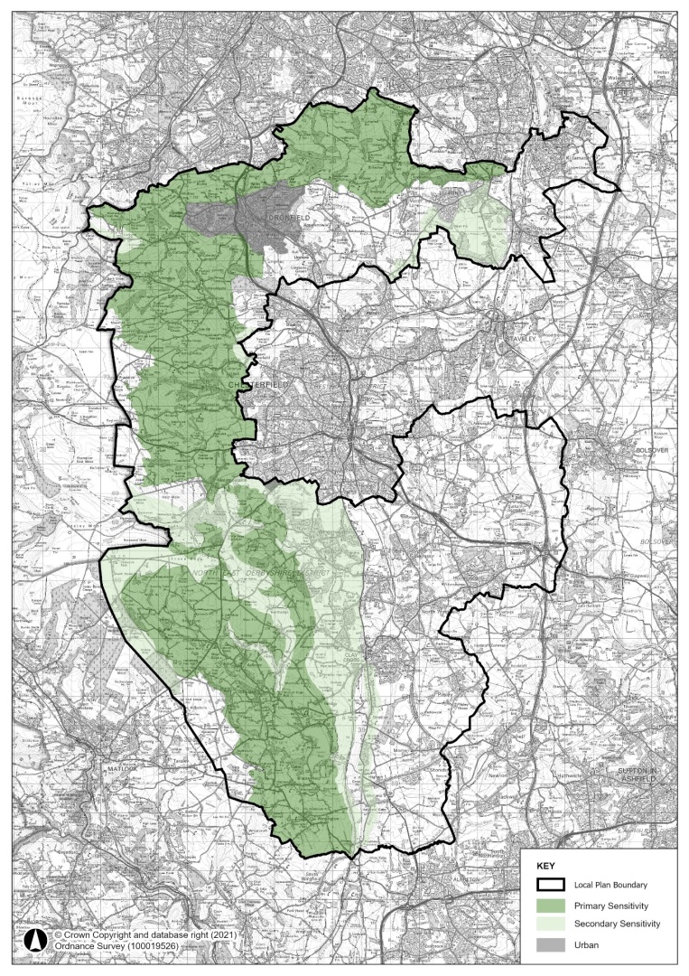
The Study identified areas potentially suitable for wind energy, assessing the potential for micro (<15m), small (15m – 50m), medium (51m -80m) and large (81-120m) to very large (>120m) turbines. Figure 8.3 presents the outputs from the report for turbines in excess of 15m high, categorising areas as ‘Less Constrained’, ‘Constrained’ and ‘Highly Constrained’. Applicants should focus on those areas identified as ‘less constrained’. It is important to stress that the areas identified as less constrained are only potentially suitable. It is not possible to comprehensively map all considerations, particularly qualitative considerations.
Similarly, the study identified potential areas that could be suitable for Ground Mounted Solar PV with a capacity of greater than 1MW generation. Figure 8.4 presents the outputs from the report for this category of Solar, again identifying areas as ‘Less Constrained’, ‘Constrained’ and ‘Highly Constrained’. As with wind power, applicants should focus on those areas identified as less constrained.
Figure 7.3 Wind Power (Turbines in excess of 15m high) Opportunity Areas
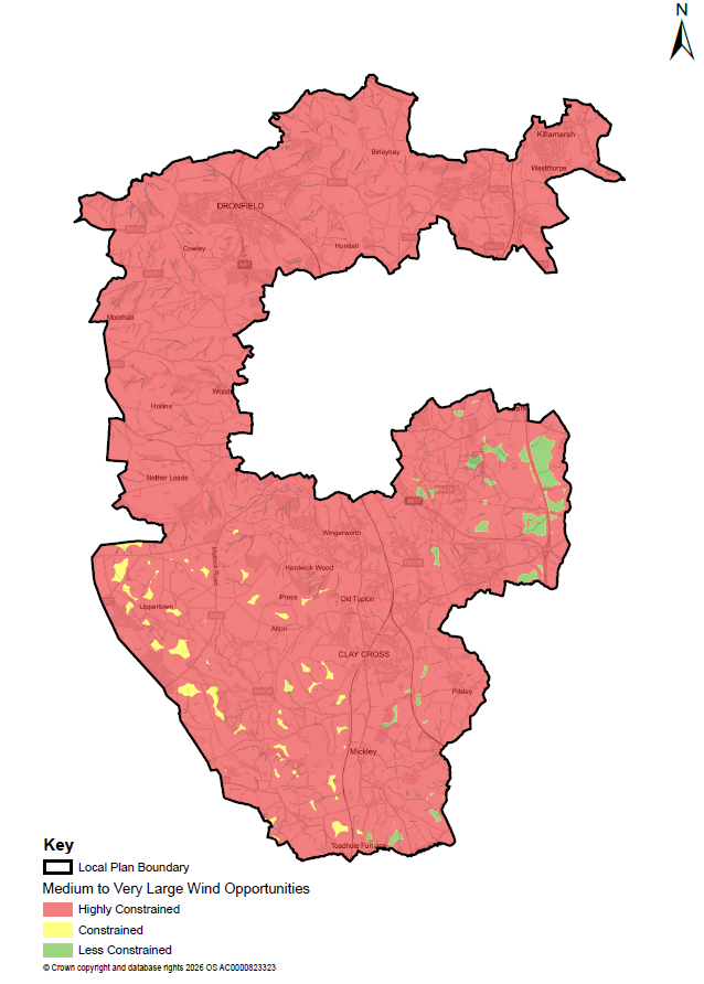
Figure 7.4 – Ground Mounted Solar PV (>1MW) Opportunity Areas
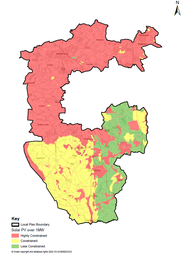
Being within an area identified as less constrained does not mean that an application would be approved and the cumulative impacts of developing a significant proportion of the land identified as potentially suitable would clearly not be appropriate.
The suitability of a specific proposal will depend on many factors, and it needs to be considered at the point of application. All renewable and low carbon energy development proposals will be assessed against the policy criteria set out in Policies SDC11, SDC12 & SDC13 below and all other relevant policies in this Local Plan, as well as policies in any relevant Neighbourhood Plan.
The type and level of information required to support proposals will vary according to the nature, location, siting, design, technology and scale of the development. Proposals should demonstrate that impacts arising at all stages of the development, including construction, operation and decommissioning, have been appropriately assessed and can be satisfactorily managed. Where development is proposed that will be of a temporary basis, including solar farms, robust arrangements will be required to ensure that all infrastructure is removed and the site is restored to an appropriate condition at the end of its operational life, supported by a suitable decommissioning and restoration plan.
Policy SDC11: Renewable & Low Carbon Energy Comment
- Proposals for renewable and low carbon energy generation, battery energy storage systems, associated infrastructure and community-led renewable energy projects will be supported where their impacts are, or can be made, acceptable.
- In determining proposals, proportionate weight will be given to the benefits of renewable and low carbon energy generation, energy storage, energy security, grid resilience and the contribution to a net zero future.
- Development proposals, individually and cumulatively, must demonstrate that unacceptable adverse effects would be avoided or appropriately mitigated in relation to:
- The visual amenity, tranquillity and character of the area, including landscape and visual impacts;
- Proposals within the Green Belt will need to demonstrate very special circumstances which outweigh the harm to the Green Belt
- The amenity of residents, in terms of noise, dust, odour, reflected light, traffic or visual intrusion;
- The ecology of the area, in particular in relation to protected species and habitats, to any sites of biodiversity value, water courses, ancient woodland, and veteran trees;
- The historic environment, including the effect on the significance of designated and non-designated heritage assets and their setting and important views associated with valued landscapes and townscapes;
- Airport radar and telecommunications systems;
- Flood risk, drainage, water quality and land contamination; and
- Highway safety, access construction and traffic impacts.
- Where appropriate, provision should be made for the decommissioning of the infrastructure and the restoration of the site, at the end of its operational life.
- Battery energy storage proposals will be supported where they facilitate renewable or low carbon energy generation, grid balancing, resilience or energy security. Such proposals must demonstrate appropriate arrangements for fire safety, emergency access, operational management and decommissioning.
Policy SDC12: Development of Onshore Wind Energy Comment
- Proposals for wind energy development (turbines in excess of 15m high) will be supported where:
- They are located within an area identified as less constrained in the Derbyshire Spatial Energy Study, or any successor document;
- All matters as set out in Policy SDC11 above have been satisfactorily addressed and with necessary mitigation measures secured;
- Appropriate residential buffers and other constraints will need to be reviewed and implemented on a site-by-site basis. Medium to large scale wind turbines (over 50m, from ground to tip of blade) should not be within 600m of any settlement, and 300m of any individual residential property. Any proposal for medium to large scale wind turbines located between 500-2000m of residential property will need clear evidence of no significant harm arising. This would include assessment of noise, flicker, overbearing nature of the turbines and any other impact on amenity of the residents.
- Proposals for smaller wind energy development (turbines under 16m high) will be assessed against Policy SDC12 above, along with any other relevant policy considerations.
Policy SDC13: Development of Solar PV Energy Comment
- Proposals for Ground Mounted Solar Photovoltaic development of >1MW will be supported where they are located within an area identified as less constrained in the Derbyshire Spatial Energy or any successor document subject to acceptably addressing all matters set out below as set out in Policy SDC13 above.
- The effective use of land will be encouraged by prioritising large scale solar farms on previously developed, contaminated land, and non-agricultural land, will be supported in principle provided that it is not of high environmental value.
- Where a proposal involves the use of greenfield land, the following factors will be considered:
- The proposed use of agricultural land has been shown to be necessary and no other previously developed or non-agricultural land is available; and
- Poorer quality agricultural land has been used in preference to higher quality agricultural land, where possible;
- The proposal allows for continued agricultural use where applicable and/or;
- Biodiversity enhancements and habitat creation around arrays are secured through the design, management and restoration of the site.
- In determining planning applications for renewable and low carbon energy generation, significant weight will be given to the achievement of wider environmental and economic benefits.
7.13 Flood Risk Comment
The water environment is an important part of North East Derbyshire's natural environment, contributing to biodiversity, landscape character, public health and quality of life. Development must be planned and designed to ensure that it does not adversely affect water resources, increase flood risk or compromise the quality of the water environment.
Climate change is expected to increase the frequency and intensity of severe weather events, including heavy rainfall and flooding. National policy requires planning decisions to minimise vulnerability to flooding, increase resilience to the effects of climate change and avoid inappropriate development in areas at risk of flooding
The Council’s Strategic Flood Risk Assessment (SFRA) (2026) provides the evidence for understanding flood risk across the district. It assesses flood risk from all sources, including rivers, surface water, groundwater, reservoirs, canals and sewer systems, and considers the implications of climate change over the plan periodThe SFRA has informed both the spatial strategy and the identification and assessment of development sites, helping to ensure that growth is directed towards areas at the lowest risk of flooding wherever possible.
Development proposals should apply a sequential approach to site selection and design, avoiding areas at greatest risk of flooding wherever possible. Where required by national policy, proposals must be supported by a site-specific Flood Risk Assessment (FRA) demonstrating that development will be safe for its lifetime, taking account of the latest climate change allowances, without increasing flood risk elsewhere.
Sustainable Drainage Systems (SuDS) should be incorporated into the design of development from the outset. As well as managing surface water runoff, well-designed SuDS can improve water quality, support biodiversity, contribute to green infrastructure, enhance local amenity and increase resilience to climate change.
Adequate foul drainage and wastewater treatment infrastructure must be available to serve new development. Where improvements to drainage or wastewater infrastructure are required, these should be delivered alongside development to ensure that flood risk, environmental quality and public health are not adversely affected.
Policy SDC14: Flood Risk and Drainage Comment
- Development proposals must demonstrate that all of the following requirements are met:
- The Sequential Test and, where required, the Exception Test have been applied in accordance with national policy;
- Development within the functional floodplain (Flood Zone 3b) is limited to water-compatible development and essential infrastructure, in accordance with national policy;
- The development will be safe for its lifetime, taking account of the latest climate change allowances, without increasing flood risk elsewhere and, where possible, will contribute to a reduction in overall flood risk, including through opportunities to improve drainage networks and increase flood storage capacity;
- All sources of flood risk, including fluvial, surface water, groundwater, sewer and reservoir flooding, have been appropriately assessed and addressed;
- Surface water is managed through Sustainable Drainage Systems (SuDS) wherever feasible, incorporating sufficient land and infrastructure within the site to manage surface water and deliver benefits for flood risk management, water quality biodiversity enhancement, green infrastructure and local amenity;
- Any exceedance flows and overland flow routes have been appropriately accommodated and managed to ensure the development remains safe and does not increase flood risk elsewhere;
- Adequate arrangements are secured for the long-term management, maintenance and operation of flood risk and drainage infrastructure; and
- Adequate foul drainage and wastewater treatment capacity exists, or can be provided in time to serve the development without causing unacceptable impacts on existing infrastructure, the water environment or public health.
- Where required by national policy and guidance, development proposals must be supported by a Flood Risk Assessment and/or Drainage Strategy demonstrating compliance with this policy. In areas susceptible to surface water flooding, the Drainage Strategy must demonstrate how surface water will be managed on site, including the use of sustainable drainage systems, exceedance flow routes and measures to ensure flood risk is not increased elsewhere.
- Where infrastructure upgrades are necessary to serve development, implementation may be phased to ensure the timely provision of the required infrastructure.
7.14 High Quality Design and Place Making Comment
Successful places tend to be those that have a distinct identity or sense of place. Good design and the creation of attractive places are not just about how buildings look. It is also about taking the opportunities available for improving the character and quality of the area as well as the way it functions as a place. Respect needs to be given to local character and context, and the quality of the buildings and the spaces around them, both public and private.
The NPPF sets out that the creation of high quality, beautiful and sustainable buildings and places is fundamental to what the planning and development process should achieve.
The Governments National Design Guide sets out 10 characteristics of a well-designed place.
Figure 7.5: National Design Guide Characteristics
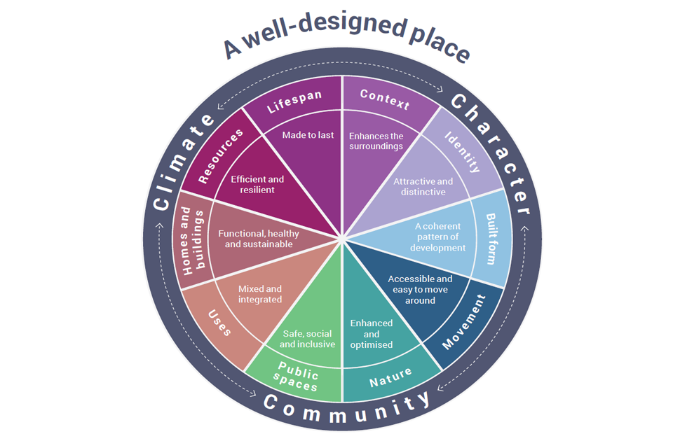
Good design is fundamental to sustainable development and the creation of high quality, beautiful, healthy and sustainable places. All development should contribute positively to the quality, character and resilience of buildings, spaces and neighbourhoods, support climate change mitigation and adaptation, and create places in which people can live, work and thrive.
Policy SDC15 sets out the design criteria that will be applied to ensure development delivers well-designed, high-quality, distinctive, and sustainable places. The policy seeks to ensure that development responds positively to its local context, reinforces the local character and identity, and makes a positive contribution to the quality and resilience of the area. It also aims to ensure that development incorporates measures to mitigate and adapt to the challenges of climate change. This set of criteria is not intended to stifle innovation or creativity but rather it provides a framework within which high-quality and sustainable design concepts can be developed.
A mix of uses is important in creating successful and sustainable places. It helps ensure that communities have easy access to shops, schools, healthcare facilities, employment opportunities, pubs and cafes, green spaces, play areas and community facilities. A well-balanced mix of uses can support day-to-day needs, encourage social interaction, reduce the need to travel and help create a strong sense of place. It can also help ensure activity throughout the day and evening, contributing to the vibrancy, vitality and resilience of an area.
The local plan policy should be read in conjunction with the guidance contained within the Successful Places: A Guide to Sustainable Housing Layout and Design. This document primarily supports the creation of locally distinctive, well-designed places to live. In particular it sets out the design process which is expected to be followed in order to demonstrate proposed development is based upon a clear appreciation of the site and its wider context. The Successful Places guidance, although dated, remains relevant and so should continue to be used in the preparation and assessment of development proposals. However, the Council is currently reviewing the document to ensure that it reflects current national planning policy, design guidance and local priorities. Any successor guidance will be subject to consultation and, once adopted, will supersede the relevant parts of the existing guidance.
On major schemes and/or those located within particularly sensitive locations the Council may seek input from specialist urban designers at an early stage in the design process. It may also seek to refer scheme designs for independent assessment through a Design Review Panel(s), and to use Building for Life as a tool to improve design elements of development. Where relevant the Council will expect the recommendations made by the Council’s appointed urban designer and/or a Design Review Panel to have been taken into consideration in the final scheme design.
Policy SDC15: High Quality, Inclusive and Sustainable Design Comment
- All development will be expected to achieve high quality, inclusive and sustainable design that makes a positive contribution to the quality, character, function and resilience of the local environment.
- Development proposals will be permitted where they meet all of the following:
- respond positively to local character, context and distinctiveness, preserving and where possible enhancing the quality, identity and setting of existing communities, landscapes, townscapes and heritage assets;
- deliver a coherent, attractive and well-related form of development, including through appropriate layout, siting, height, scale, massing, density, elevational treatment, roof form, materials, detailing, streetscape, boundary treatment and landscaping;
- provide well-connected, legible and inclusive places that are easy and safe to move around, prioritise walking, wheeling and cycling, support access to public transport, and make appropriate provision for servicing, vehicle parking and cycle parking;
- provide streets, routes and public spaces that are attractive, accessible, overlooked, active, well-connected and capable of supporting social interaction, play, recreation and are inclusive;
- provide a network of public open spaces and green and blue infrastructure that connects with existing networks wherever possible and supports ease of movement, biodiversity, climate adaptation and health and wellbeing;
- retain, enhance and integrate important existing site features as positive elements of the design;
- protect the amenity of existing occupiers and secure a high standard of amenity for future users;
- provide homes, buildings and spaces that are fit for purpose, accessible, adaptable and resilient, with internal and external space appropriate to their intended use, meeting National Space Standards where applicable, including suitable private amenity space, storage, waste and recycling facilities;
- incorporate sustainable design and construction practices into development to ensure climate change adaptation and mitigation;
- minimise opportunities for crime, disorder and anti-social behaviour through well-considered layout, and secured by design principles; and
- demonstrate that flood risk, drainage, land stability, contamination, pollution, mining legacy and other site constraints have been considered at the design stage and addressed in a way that supports safe, resilient and sustainable development.
- Major development, development in sensitive locations, and proposals likely to have significant landscape, townscape, heritage, design or public interest impacts should demonstrate how design quality has been embedded from the outset. Where requested by the Council, this should include proportionate design assessment, engagement, design coding, master planning or independent design review undertaken early enough to influence the evolution of the scheme.
7.15 Environmental Quality Comment
Planning has an important role to play in making sure that new development does not have, and is not at risk from, adverse environmental effects. Pollution can occur in terms of water, air, noise, light and land. Ensuring a safe environment is a prerequisite for safe and healthy communities and quality of life. Consideration should be given to both the effects of development and the effects of existing uses on new sensitive receptors. Assessments should be proportionate to the scale, nature and likely impacts of the proposal and should consider construction, operation and, where relevant, decommissioning.
The history of North East Derbyshire as a location for mineral extraction and heavy engineering has, in places, left a legacy of land that has been affected by contamination from its former use. It is therefore important that the quality of both groundwater and surface water supplies are protected from contamination. It is also important to locate, design and manage new development so as not to give rise to unacceptable impacts on sensitive land uses or features. New sensitive land uses should not be located where they may be affected by the otherwise acceptable effects of established uses.
7.16 Air Quality Comment
Clean air is essential to health, wellbeing and environmental quality. The existing and future air quality of an area should be considered through the preparation of Local Plans and in the determination of planning applications where air quality impacts may arise. Development should minimise emissions of air pollutants and, where appropriate, incorporate measures that contribute to improved air quality and reduced exposure to pollution.
Local authorities have statutory duties under the Local Air Quality Management framework (LAQM) (established by Part IV of the Environment Act 1995 and reinforced by the Environment Act 2021) to review and assess local air quality against national air quality objectives. Where monitoring indicates that air quality objectives are unlikely to be achieved, the Council is required to declare an Air Quality Management Area (AQMA) and prepare an Air Quality Action Plan (AQAP) setting out measures to secure improvements in local air quality.
Air quality also forms an important component of the Government's wider environmental objectives, including the legally binding fine particulate matter (PM2.5) targets established under the Environment Act 2021 and the Environmental Targets (Fine Particulate Matter) (England) Regulations 2023. Parts of the eastern area of the district are more influenced by emissions associated with the M1 motorway and other strategic transport routes, particularly in relation to nitrogen dioxide (NO₂) and particulate matter. Development proposals should therefore avoid exacerbating existing air quality issues and, where appropriate, incorporate mitigation measures to minimise emissions and exposure to air pollutants.
In addition to protecting human health, development should avoid adverse effects on biodiversity and designated nature conservation sites. These include Special Protection Areas (SPAs) and Special Areas of Conservation (SACs), which together form part of the National Site Network. Development proposals that have the potential to increase air pollution or otherwise affect the integrity of a protected Habitats Site, either alone or in combination with other plans or projects, will be subject to assessment under the Conservation of Habitats and Species Regulations 2017 (as amended). Where a likely significant effect cannot be ruled out, the competent authority will be required to undertake an Appropriate Assessment before planning permission can be granted.
7.17 Noise and tranquillity Comment
Noise can have significant effects on health, wellbeing, quality of life, biodiversity and the enjoyment of places. Noise pollution is created by man-made sources including but not limited to, road traffic, railways, industrial and commercial activities and construction activities. Noise pollution is noise which is excessive, causes disturbance or annoyance, and can affect wildlife and sensitive areas, including areas known for their tranquillity. The Noise Policy Statement for England[34] seeks to promote good health and a good quality of life through the effective management of noise, whilst recognising the benefits of sustainable development. Planning decisions should therefore ensure that development is appropriate to its location, taking account of the likely effects of noise on health, living conditions and the natural environment. Development should also seek to avoid significant adverse effects from noise, mitigate and minimise adverse impacts wherever possible, and protect areas of tranquillity that are valued for their recreational, environmental or amenity benefits.
7.18 Light Pollution Comment
Light pollution is artificial light that is allowed to illuminate areas that are not intended to be lit. The intrusion of overly bright or poorly directed lights can cause glare, wasted energy, have impacts on nature conservation, and affect people's right to enjoy their property. It can also severely affect views of the night sky. The NPPF is clear that planning policies should limit the impact from light pollution on local amenity, intrinsically dark landscapes, and nature conservation, primarily through promoting and requiring high-quality design in order to reduce light pollution and the impacts that it causes, and by ensuring that lighting is appropriate to its location and purpose. Planning decisions should protect local amenity, conserve and enhance the natural environment, and minimise unnecessary light pollution.
The Council will seek to where possible reduce light pollution by encouraging the installation of appropriate lighting and only permitting lighting proposals which would not adversely affect amenity or public safety. External lighting should be appropriately shielded, directed to the ground and sited to minimise any impact on adjoining areas, and of the minimum height and level of illumination required to serve their purpose.
7.19 Soil Quality Comment
It is government policy to protect and enhance the natural environment by preventing both new and existing development from being adversely affected by unacceptable levels of soil pollution. Soil is essential for achieving a range of important ecosystem services and functions including food production, carbon storage and climate regulation, water filtration and flood management and support for biodiversity and wildlife. Soil is a finite resource, and it needs to be conserved and managed in a sustainable way.
Some of the most significant impacts on soils occur as a result of activities associated with construction activity. A Code of Practice[35] has been developed by Defra to assist anyone involved in the construction sector to better protect the soil resources with which they work and in doing so minimise the risk of environmental harm. The council strongly encourages developers to have regard to the practical guidance in the Code of Practice.
7.20 Water Quality Comment
The Water Framework Directive (WFD)[36] is the primary European legislation for matters relating to the water environment and sets out how water bodies will be managed within the context of River Basin Districts. A high proportion of the rivers in the North East Derbyshire District are headwaters or tributaries of larger rivers and are highly sensitive to water quality impacts. As they are headwaters that ultimately flow into other catchments, water quality in this area has the potential to affect water bodies over a much larger area.
It is important to consider the protection of water resources from pollution, which can affect the district’s watercourse network consisting of rivers, streams, ditches, drains and canals. However, it can also affect groundwater for many decades and may be impossible to remove completely, even after the source of the pollution has been cleared up. Policy SDC16 aims to ensure water quality issues are addressed and that development helps to assist improvements in the ecological status of the district’s watercourse network.
Policy SDC16: Environmental Quality Comment
- Development will be permitted only where it would not result in unacceptable adverse effects, either individually or cumulatively, on public health, quality of life, amenity, biodiversity, geodiversity, water quality, air quality, soil, tranquillity or the wider environment.
- All development proposals will be assessed in relation to their impact on air, light, noise, ground, land contamination, and water pollution.
- Development proposals will be expected to contribute positively to the water environment and watercourse ecology and will only be permitted where they do not adversely affect surface or ground water quality in line with the requirements of the Water Framework Directive.
- Proposals that may affect air quality, including impacts on Habitats sites, must provide proportionate assessment and mitigation where required. Development will not be permitted where air quality impacts would result in unacceptable harm to public health, amenity, protected habitats or designated sites.
- Planning applications for development with the potential to pose a risk of pollution should be accompanied by an assessment of the likely impact of the development on environmental quality. Assessments of the risk of air, light, noise, ground or water pollution should relate to all stages of development.
7.21 Land potentially affected by Contamination and Land Instability Comment
Sustainable development includes the recycling of previously developed land (brownfield sites) for new uses. This includes sites potentially affected by contamination.
New development can provide the opportunity to address the risks to health, and the environment associated with potential contamination and unstable land by bringing about its improvement through risk management. National guidance also advises on the need to identify, at the earliest possible stage of the planning process, whether or not a site is affected by contamination. Land can become contaminated[37] from a variety of sources but is typically associated with some particular types of industrial and manufacturing processes, such as gas, chemical and steel works.
National guidance states that if there is a reason to believe contamination could be an issue, developers should provide proportionate but sufficient site investigation information (a risk assessment) to determine the existence or otherwise of contamination, its nature and extent, the risks it may pose and to whom/what (the ‘receptors’) so that these risks can be assessed and satisfactorily reduced to an acceptable level.[38]
The principle issues relating to ground instability across North East Derbyshire relate to past coal mining activity. Large parts of the District, particularly in the south and east, have been identified by the Coal Authority as being within ‘Development High Risk Areas’ due to the known occurrence of coal mining legacy issues and related hazards. In these areas, coal mining legacy issues have the potential to create unstable land and risks to surface development.[39] It is therefore necessary to demonstrate how new development proposals will be safe and stable.
Failure to deal adequately with contamination or instability can cause harm to human health, property and the wider environment. All planning applications for new development on sites which are potentially contaminated or are underlain by potentially unstable land should be accompanied by a preliminary assessment to identify and evaluate all potential sources of contamination or ground instability and the impact on land or controlled waters relevant to the site. In some cases, further detailed assessment of risk may be required prior to the determination of planning applications. The aim is to ensure that new development is appropriate for its location and that the physical constraints on the land are taken into account at the planning application stage. Land affected by contamination often contains valuable areas of biodiversity, and historical interest. In some cases, a careful balance will need to be struck between the benefits of remediation and the harm to other interests, based on the collection and submission of sufficient information by developers at the planning application stage.
Policy SDC17: Land potentially affected by Contamination or Instability Comment
- Development proposals will not be permitted unless it can be demonstrated that any land potentially affected by contamination or instability will be addressed by appropriate mitigation measures to ensure that the site is suitable for the proposed use, and does not result in unacceptable risks which would adversely impact upon human health, and the built and natural environment.
- Development proposals should also demonstrate that they will not cause the site, or the surrounding environment, to become contaminated and/or unstable.
- Where necessary, the developer will be required to carry out investigations and undertake any necessary risk management measures to ensure that any contamination or unstable land issues are addressed prior to the commencement of the development.
7.22 Hazardous Installations Comment
The NPPF states that planning policies should be based on up-to-date information on the location of major hazards and on the mitigation of the consequences of major accidents. The Health and Safety Executive (HSE) provide planning advice to local authorities on developments which fall within the consultation zones of hazardous installations.
There are a number of hazardous consultation zones which affect the district, one of which relates to an operation just outside of the district. These installations are regulated by the Health and Safety Executive in accordance with Control of Major Accident Hazards (COMAH) regulations:
- Veolia Environmental Services, Norwood Industrial Estate, Killamarsh
- Caldic UK Ltd, Holmewood Industrial Estate, Holmewood
- Xtratherum UK Ltd, Holmewood Industrial Park, Holmewood
- EPC UK Ltd, Rough Close Works, South Normanton
Each installation has consultation zones around it which are determined by the HSE depending upon the materials stored and the technology operated at the site; these are periodically updated by the HSE. When considering applications for development in or near a hazardous installation or pipeline regard must be had to the most up to date consultation zones.
Where proposals fall within the HSE consultation zones then the local planning authority will consult the HSE and apply its methodology and advice. This will normally result in either a “Do not Advise Against” or “Advise Against” determination based on the level of risk proposed to prospective occupants of the development.
Policy SDC18: Development near Hazardous Installations Comment
Development proposals will be assessed in accordance with the Health an Safety Executive (HSE) guidance where they fall within a consultation zone for one or more hazardous installations. Where the HSE advises against the development proposed then permission will be refused.
7.23 Safeguarding Mineral Resources Comment
Mineral resources are essential to support economic growth and are a natural finite resource. It is therefore important to make the best use of them to ensure their long-term conservation. The NPPF requires Authorities to ensure that minerals of local and national importance are not needlessly sterilised by non-mineral development. It also requires the prior extraction of minerals to be considered where practicable and feasible, if non-mineral development is proposed in areas containing potentially workable mineral resources.
Derbyshire County Council is the Minerals and Waste Planning Authority for North East Derbyshire. The statutory development plan for minerals and waste currently comprises the adopted Derby and Derbyshire Minerals Local Plan (2000, amended 2002), the Derby and Derbyshire Waste Local Plan (2005), together with any policies which continue to be saved. These plans contain policies relating to mineral safeguarding and consultation procedures that may be relevant to the consideration of development proposals.
Derbyshire County Council and Derby City Council submitted the Derbyshire and Derby Minerals Local Plan for independent examination in November 2024, and it remains under examination. The submitted plan identifies proposed Mineral Safeguarding Areas (MSAs) and Mineral Consultation Areas (MCAs) to help prevent the unnecessary sterilisation of important mineral resources. Mineral Safeguarding Areas identify known mineral resources that should be protected from sterilisation by non-mineral development, whilst Mineral Consultation Areas identify locations where Derbyshire County Council should be consulted on specified development proposals that may affect those resources. Within North East Derbyshire, the proposed safeguarding areas principally relate to surface coal resources together with limited areas of Carboniferous Limestone. The emerging plan and any associated safeguarding policies may be material considerations in the determination of planning applications, depending on the stage of plan preparation and the extent of any unresolved objections.
[25] Wildlife and Countryside Act 1981
[26] Conservation of Habitats and Species Regulations 2017
[27] Section 41 of the Natural Environment and Rural Communities Act 2006
[28] NPPF(2024), paragraph 187(a)
[29] Where a Landscape Description Unit is recorded as significant for all three of the data sets (ecology, historic landscape environment and visual unity) then it is considered to be of Primary Sensitivity. If a Landscape Description Unit is recorded as being significant in 2 data sets than it is considered to be of Secondary Sensitivity.
[30] The GI Study includes a map showing the Derbyshire-wide results of the Areas of Multiple Environmental Sensitivity.
https://www.ne-derbyshire.gov.uk/documents/eb-iv3a-green-infrastructure-strategy/download
[31] Technical Support Document 2: Tranquillity (2013)
[32] NPPF(2024), paragraph 187, (b) & (d).
[33] [Insert link to ‘A Plan for Nature’
[34] https://www.gov.uk/government/publications/noise-policy-statement-for-england
[35] Construction Code of Practice for the Sustainable Use of Soils on Construction Sites, Defra
[36] Although the UK is no longer an EU member, the core tenets of the WFD were transposed into domestic law (e.g., through the Water Environment Regulations) and remain legally active across England, Wales, Scotland, and Northern Ireland.
[37] Contaminated land can be regarded as any land which is in such a condition by reason of substances in, on, or under the land, that can cause a risk to human health, property, or the wider environment.
[38] NPPG (2014), reference ID: 33-007-20140612
[39] Further information about the Coal Authority's Risk Based Approach can be found on the Coal Authority's website: http://coal.decc.gov.uk/en/coal/cms/services/planning/strategy/strategy.aspx
