
1. Publication Draft North East Derbyshire Local Plan 2024 - 2044 (Reg 19)
Other elements in this consultation
4 Spatial Strategy and Strategic Policies Comment
4.1 Introduction Comment
The purpose of this chapter is to set out the Spatial Strategy and Strategic Policies that the Council will follow to achieve its Vision and Objectives. The achievement of sustainable development forms the basis of the strategic approach which seeks to deliver new development and associated supporting infrastructure to meet future needs of the District in the locations where it is most needed whilst at the same time protecting valued assets and resources.
4.2 Sustainable Development Comment
The purpose of the planning system is to contribute to sustainable development[3]. The goal of sustainable development is to enable all people to satisfy their basic needs and to enjoy a better quality of life, without compromising the ability of future generations to meet their own social, economic and environmental needs.
The Local Plan’s vision and objectives are centred on sustainable growth. For North East Derbyshire, this means allocating sufficient land to meet identified housing and employment needs and directing development to those locations that are well served by services and facilities or have the realistic potential to be well served; and where the environmental impacts can be most effectively mitigated.
Policy SS1 sets out the economic, social, and environmental dimensions of sustainable development and what this means in North East Derbyshire. In light of the rural nature of North East Derbyshire this means focusing the majority of development in and around the most sustainable locations, where the best use can be made of existing infrastructure, services and facilities; whilst at the same time meeting the essential needs of smaller rural communities in an appropriate way. A hierarchy of settlements has been established to identify the relative sustainability of places and to focus development in the right places. Other policies in the plan clearly set out the scale and nature of development that is appropriate within the different settlement categories to ensure that development enhances the place it becomes part of.
The identification of settlement boundaries creates a clear distinction between areas that are considered to form part of the built form or wider environs of a settlement and are therefore considered suitable for planned or windfall development. Countryside policies apply to land outside of these settlement boundaries (unless allocated for other uses).
Policy SS1: Sustainable Development Comment
- In order to contribute to sustainable development in North East Derbyshire, development proposals will:
- Meet development needs within defined settlements or other allocated areas having regard to the defined settlement hierarchy and the need to enhance their role as a focus for new services and facilities (Policy SS10 & Table 4.2);
- Promote the efficient use of land and the re-use of previously developed land (including the remediation of contaminated land) buildings and existing infrastructure in sustainable locations (Policies SS4 - SS12);
- Locate development where there is access to a broad range of jobs, services and facilities which are accessible by foot, cycle or public transport with reduced reliance on the private car in accordance with the settlement hierarchy (Policy SS4);
- Support the local economy by contributing towards business expansion and growth, attracting and supporting a skilled labour force, and improving skills and access for local people to job opportunities including targeted recruitment and training, and the use of Local Labour Agreements (Policies WC1 and WC2);
- Ensure development uses design techniques that increase energy efficiency and maximise the use of renewable energy sources (Policy SDC10);
- Promote the social and economic wellbeing of North East Derbyshire’s communities and contribute to reducing social disadvantages and inequalities (Policies LC3, WC1, WC2, and ID4);
- Create well designed places that are accessible, durable, adaptable and enhance local distinctiveness (Policy SDC15);
- Protect and enhance the character, quality and settings of towns and villages and heritage assets (Policies SDC5-10 and SDC15);
- Protect and/or enhance the character, quality and diversity of the District’s green infrastructure and local landscapes, the wider countryside and ecological and biodiversity assets (Policies SS4, SS11,SDC1-42 – SDC9, SDC15, ID7 and ID9,);
- Protect the productive potential of the District’s best quality agricultural land, and avoid sterilisation of mineral resources;
- Support the provision of essential public services and infrastructure (Policies SS4, ID1 – ID10);
- Play a positive role in adapting to and mitigating the effects of climate change, including through the use of sustainable drainage systems, to contribute to the health and wellbeing of communities and the environment through the location, design and operation of development (Policies SS2 - 4, SDC11 – SDC16);
- Take account of any coal-mining related land stability and / or other public safety risks, and where necessary, incorporate suitable mitigation measures to address the risk (Policies SDC17, SDC18).
4.3 Climate Change Comment
Climate change presents a significant challenge at all levels, globally, nationally and locally. It is widely accepted that human activity is the main reason for increased concentrations of greenhouse gases and rising global temperatures. Unless we take steps now, the impacts of climate change that we are already experiencing will only worsen for future generations. Locally, the more visible impacts of rising temperatures include more extreme weather events ranging from prolonged dry spells and water shortages to flooding. Longer term impacts are also likely to include rising sea levels and increased coastal flooding.
Furthermore, the impact on health is significant, caused by extreme heat, severe weather, air pollution, increased allergens, and environmental degradation. The response to the challenge posed by climate change therefore affects many aspects of life and society.
The Climate Change Act 2008 sets out that carbon emissions are set to be reduced by 80% in 2050 compared to 1990. In 2019, the UK government changed this target to be net zero on carbon emissions by 2050. In addition, the Planning and Compulsory Purchase Act 2004 (reinforced by the Levelling Up and Regeneration Act 2023) includes a requirement for Local Development Documents (taken as a whole) to include policies designed so that development and the use of land contribute to the mitigation of, and adaptation to, climate change.
In March 2026, the government introduced the Future Homes Standard (FHS). The FHS requires that new homes must produce at least 75% less carbon emissions than homes built to the 2013 Part L baseline. This is a substantial step beyond the 2021 Part L uplift, which required a 30% reduction. The target is achieved through a combination of low-carbon heating, improved fabric performance, and on-site renewable generation.
In 2019, the Council declared a Climate Emergency, acknowledging the urgent need to address climate change and its impacts. The Council has expressed its commitment to the challenge of tackling climate change and reducing our carbon emissions in order to reach net zero by 2050. The Council’s Climate Change Strategy 2024-2030, sets out the framework, supported by an Action Plan, for reducing emissions and enhancing sustainability across the district. The strategy focusses on several key areas, such as reducing carbon emissions and pollution, enhancing biodiversity and encouraging residents, businesses and organisations to participate in climate initiatives.
National planning policy for climate change is contained in the NPPF. Paragraph 20 (d), when discussing Strategic Policies, states that these should include planning measures to address climate change mitigation and adaptation.
Paragraph 161 states that the planning system should support the transition to a low carbon future in a changing climate. The planning system should help to:
- shape places in ways that contribute to radical reductions in greenhouse gas emissions
- minimise vulnerability and improve resilience
- encourage the reuse of existing resources including the conversion of existing buildings
- support renewable and low carbon energy and associated infrastructure
The Local Plan plays a crucial role in shaping the district’s response to climate change. Climate change is a key strategic issue by integrating climate considerations throughout the Local Plan, the Council can proactively address environmental challenges, support economic growth and improve the quality of life for residents. The Local Plan has a key role to promote:
- energy efficiency, encourage more use of renewable energy, and manage flood risk;
- sustainable development, its distribution and density, to reduce the need to travel;
- healthy communities, good air quality, open space and green infrastructure;
- sustainable design of buildings and places;
- green travel, including public transport, walking, and cycling and support electric vehicle charging points and any other relevant technology which might be introduced; and
- increased biodiversity.
For major development compliance with Policy SS2 should be demonstrated through a standalone Climate Change Impact Assessment in support of planning applications. The level of information provided should be proportionate to the scale and nature of the proposed development, and the assessment should demonstrate the measures taken to address each of the policy criteria.
For major non-residential development, applicants are encouraged to have regard to recognised sustainability assessment frameworks, such as BREEAM or any successor standard, when designing and delivering development. Such frameworks can assist in demonstrating how proposals address energy efficiency, water consumption, materials, waste, ecology, transport, health and wellbeing, and wider sustainability considerations. The Council does not require a specific certification level but will have regard to information submitted through such frameworks as part of the Climate Change Impact Assessment where provided.
For minor development applications[4], the Climate Change Impact Assessment may form part of a Design and Access Statement or Planning Statement for the proposal.
Climate change mitigation and adaptation is a cross-cutting theme that has influenced other plan policies, including, but not limited to, Sustainable Design, Flooding, and Infrastructure. The following policy therefore provides a strategic framework to address climate change and a basis for a holistic approach through the overall Local Plan.
Policy SS2: Adapting to Climate Change Comment
- Development proposals will be required to minimise greenhouse gas emissions and support adaptation to the impacts of climate change. Development must, where relevant and proportionate to its scale, nature, and location address each of the following criteria:
- Be designed sustainably, taking account of orientation, massing, layout, materials, future proofing and adaptability.
- Minimise energy demand through a fabric-first approach.
- Minimise construction waste and maximise opportunities for resource efficiency, reuse, recycling and sustainable construction methods.
- Maximise the generation and use of renewable, low-carbon and decentralised energy.
- Be located in sustainable locations accessible by public transport, reducing the need to travel by private car.
- Prioritise walking, cycling, public transport and other sustainable active travel modes through the provision of safe and attractive routes and connections.
- Incorporate multi-functional blue and green infrastructure that contributes to climate change adaptation, urban cooling, flood risk management and biodiversity enhancement.
- Direct development away from areas at highest risk of flooding and protect the water environment from pollution.
- Incorporate measures to minimise water consumption and improve resilience to drought.
- Reduce embodied carbon through the retention, reuse and adaptation of existing buildings and the use of lower-carbon materials where feasible.
- Major development proposals, and other forms of development where proportionate[5], should be accompanied by a climate change impact assessment demonstrating how the proposal has addressed climate change mitigation and adaptation in line with the policy criteria 1a - j. For major non-residential development, this may include reference to recognised sustainability assessment methodologies such as BREEAM or any successor standard.
4.4 Health and Wellbeing Comment
The planning system was born out of a need to improve people's health and wellbeing and to reduce health inequalities. The National Planning Policy Framework recognises that policies should aim to achieve healthy, inclusive and safe places.
The Health and Social Care Act (2012) also gave local authorities new duties and responsibilities for health improvement and health protection.
The Local Plan therefore has a key role to play in ensuring that new development delivers environments that are healthy and safe. Objective S06 seeks to” improve physical and mental health outcomes and reduce health and social inequalities across North East Derbyshire by promoting healthy placemaking, healthy homes, active and sustainable travel, access to healthcare, education and community facilities, high-quality green and blue infrastructure, and the creation of safe, accessible and inclusive communities.”
The physical and natural environment has a huge role to play in providing people with the opportunities to be physically active and to enhance mental wellbeing and enable them to feel part of a community, along with reducing health inequalities. The planning system can therefore play an important role in facilitating healthy housing; active travel; a healthy environment; and vibrant neighbourhoods. Health, well-being and safety are major issues on the local and national agenda and are closely interrelated.
Planning also shapes access to healthcare and can limit health-harming uses like fast-food outlets near schools. Currently, some of the key challenges[6] facing NEDDC are:
- Physical activity levels are below the national average - Only 64.9% of adults are classed as physically active, compared with 68.0% nationally.
- Higher levels of overweight and obesity among adults (68.3% compared with 64.6% nationally) and higher rates of musculoskeletal conditions and diabetes.
- Increasing Health Needs Associated with an Ageing Population - Emergency hospital admissions due to falls among people aged 65 and over are significantly higher than the England average (2,306 per 100,000 compared with 1,958 nationally).
- Poorer Outcomes for Long-Term Health Conditions - The proportion of adults reporting a long-term musculoskeletal condition is considerably higher than nationally (26.4% compared with 18.4% nationally). In addition, diabetes diagnosis rates exceed the England average.
- Persistent Health Inequalities - Although many health indicators perform well, inequalities remain. Female life expectancy inequality[7] at birth is greater than the England average (9.3 years compared with 8.0 years), indicating that health outcomes vary significantly between different communities within the district.
- Preventable Ill-Health Linked to Lifestyle Factors -Alcohol-related hospital admissions exceed the national average (542 per 100,000 compared with 504 nationally), while smoking during pregnancy remains higher than England levels (8.0% compared with 6.1%).
There are also health disparities between those who live in the most deprived areas compared with those in the least deprived areas[8].
These issues demonstrate that preventable ill-health remains a challenge within the district and underlines the importance of healthy place-making and access to local health services.
The Local Plan will therefore seek to ensure that developments deliver healthy environments that provide residents with realistic active and sustainable travel choices, usable open spaces for play and recreation, and healthy homes.
Whilst the following policy is strategic, health and wellbeing is a cross-cutting theme in the Local Plan, influencing and explicitly supporting the development of other policy areas including, but not limited to, design, transport, green space, climate change and housing.
Policy SS3: Health and Wellbeing Policy Comment
- The Council will support development in North East Derbyshire that provides opportunities for healthy lifestyles, contributes to the creation of healthier communities and helps to reduce health inequalities.
- Development should contribute to improving health and wellbeing meeting all of the following:
- Achieving high-quality design and placemaking that addresses any adverse health and wellbeing impacts; and
- Providing safe, attractive walking, wheeling, cycling and public transport links to key destinations and green spaces; and
- Protecting and enhancing accessible green and blue infrastructure; and
- Reducing exposure to air, noise and light pollution; and
- Ensuring good access to health facilities and services; and
- Consider and provide for the specific requirements of different groups in the community (e.g. families with children, older people, people with disabilities) in all relevant development
- The Council will support the provision of health facilities to accommodate primary and secondary needs in accessible locations which contribute towards health and wellbeing.
- Development that would have an unacceptable impact on health or wellbeing will not be permitted.
4.5 Housing and Employment Targets and Provision Comment
4.5.1 Housing Target and Supply Comment
The NPPF states that to “determine the minimum number of homes needed, strategic policies should be informed by a local housing need assessment, conducted using the standard method in national planning practice guidance” (NPPF Dec 2024, para. 62). The application of the standard method identifies a need for 563 homes per year equating to 11260 over the 20 year plan period). Achieving this target is a central driver of the strategic approach to spatial distribution of development set out in this Plan.
Table 4.1 sets out the components of the housing land supply This comprises 964 dwellings that have been built since 2024, and a further 1822 commitments - dwellings with planning permission that are considered to be deliverable and developable within the Plan period, the majority of which are shown as allocations on the Policies Map. Some 296 dwellings are not shown as allocations, due to their small size or build out stage. 9231 dwellings without planning permission are allocated. Together the sources of housing supply amount to a total of 12,017 dwellings, providing approximately 7% flexibility in relation to the overall housing requirement of 11,260 dwellings. Additional flexibility will also be provided by minor site windfalls, which are expected to provide for approximately 75 dwellings per year based upon past trends. This increases the overall buffer to approximately 15%.
Table 4.1: Components of Housing Target & Supply
|
Housing Target – 2024 - 2044 |
Number of dwellings |
|---|---|
|
Housing Need (Standard Method) – 563 dwellings per year |
11,260 |
|
Total Target |
11,260 |
|
Housing Supply – 2024 - 2044 |
|
|
Housing Completions 2024-2026 |
964 |
|
Minor commitments at 31/03/2026 (minus 7% lapse rate) |
249 |
|
Major commitments at 31/03/2026 (not allocated) |
47 |
|
Allocations (with planning permission at 31/03/2026 i.e commitments) |
1,526 |
|
Allocations (without planning permission) |
9,231 |
|
Total Supply |
12,017 |
4.6 Employment Growth and Land Provision Comment
The Local Plan seeks to support sustainable economic growth alongside the delivery of new homes, ensuring that a range of deliverable and marketable employment land is available for both indigenous businesses and inward investment. In doing so, the Council recognises the District's economic relationships with neighbouring authorities within the wider Functional Economic Market Area (FEMA), its position within the East Midlands Combined County Authority (EMCCA) and close links with the South Yorkshire Mayoral Combined Authority (SYMCA).
EMCCA's 10-Year Growth Plan provides an important strategic context for the Council's approach to economic growth. The Plan supports the unlocking of major employment sites, maintaining an appropriate supply of employment land and premises, and working with partners to develop, manage and enhance key strategic employment locations.
The District has a diverse economy and there is a need to provide a range of employment sites of differing sizes and types. The Local Plan therefore seeks to provide employment opportunities across the District alongside new housing, enabling people to live close to their place of work wherever possible. In particular, the Plan aims to support the delivery of strategic and major employment sites capable of enhancing economic performance, attracting investment and supporting the regeneration of the District's towns and communities.
The 2025 Economic Needs Assessment Study (ENAS) identified an employment land requirement for North East Derbyshire of between 15.6ha and 30.3ha over the period 2022-2044. The lower end of the range is based on baseline economic forecasts, whilst the upper end reflects a labour supply scenario that considers the level of employment growth that could potentially be supported by the increase in labour supply associated with the Standard Method housing requirement. The ENAS also assessed a Policy-On scenario, reflecting accelerated growth in key sectors and the economic ambitions of the emerging Local Plan and wider sub-regional growth strategies. Unlike the labour supply scenario, the Policy-On scenario forecasts likely job growth and associated employment land demand and is therefore considered to provide the most appropriate basis for establishing the Plan's indigenous employment land requirement.
Accordingly, the Plan makes provision for a net increase of 20 hectares of employment land to meet indigenous employment needs. This level of provision reflects the employment land requirement generated by the Policy-On scenario and provides capacity for business growth, inward investment, redevelopment and modernisation of the employment land portfolio. It also allows the Council to review existing employment allocations and, where appropriate, support the redevelopment of sites that are no longer well suited to modern employment requirements. The ENAS also identified a residual need within the North Derbyshire FEMA for between two and three strategic B2/B8 logistics parks. In response, Policy SS9 allocates approximately 35 hectares of land south of Markham Vale Business Park to contribute towards addressing the identified need for strategic logistics development.
The employment land strategy therefore seeks not only to provide sufficient land to meet identified employment needs but also to improve the quality and market attractiveness of the District's employment land portfolio by ensuring that sites are well located, deliverable and capable of meeting modern business requirements.
The employment land provisions also have regard to national policy, including the requirement in the NPPF to avoid the long-term protection of employment sites where there is no reasonable prospect of the land being used for that purpose. The ENAS recommends that the Council consider whether some existing employment allocations continue to serve a useful economic function or whether alternative forms of economic development may be more appropriate. Consequently, existing employment allocations have been reviewed to ensure that the portfolio of sites remains fit for purpose and responsive to market demand.
The Local Plan seeks to safeguard and enhance successful employment areas whilst allocating new sites to improve the overall employment land portfolio. New manufacturing, industrial and distribution development will be directed towards previously developed land wherever possible and, where justified, to sustainable greenfield locations with good accessibility.
It is recognised that employment growth is increasingly generated through sectors that fall outside traditional employment land uses, including leisure, healthcare, education and other service sectors. National Planning Practice Guidance recognises a broad definition of economic development, and the Plan therefore adopts a positive approach to appropriate sui-generis and other non-B Class employment-generating uses, subject to criteria which ensure that proposals remain compatible with neighbouring uses and the primary role of employment areas.
4.7 Balancing Housing and Economic Growth Comment
The Plan seeks to promote sustainable growth that supports both economic development and the needs of a growing population. The ENAS indicates that the level of labour supply associated with the Standard Method housing requirement would be capable of supporting a greater level of employment growth than that generated by the indigenous employment land requirement alone. In addition to the provision of 20 hectares of employment land for indigenous needs, the Plan allocates a 35-hectare strategic logistics site to contribute towards meeting identified strategic logistics requirements within the North Derbyshire FEMA. Taken together, the Plan's employment land provisions provide capacity for employment growth which broadly aligns with the labour supply generated by the housing requirement, ensuring an appropriate balance between homes, jobs and economic opportunity.
4.8 Distribution of Growth and the Settlement Hierarchy Comment
In accordance with the principles of sustainable development and Policy SS1, the Local Plan directs growth towards the District's most sustainable locations. The spatial strategy is based on the Settlement Hierarchy and Strategic Growth Locations, including urban extensions, strategic sites and new settlements. Development is focused in locations with good access to employment, services, facilities and public transport, and where infrastructure exists or can be provided to support growth.
The distribution of growth has been determined through a plan-led assessment of the District's capacity to accommodate development. While the Settlement Hierarchy provides the starting point for this assessment, site selection has also been influenced by factors including Green Belt designation, environmental constraints, infrastructure requirements, landscape impacts and site deliverability. As a result, the level of development directed to individual settlements does not always correspond directly with their position in the hierarchy.
The strategy has sought to maximise development opportunities outside the Green Belt wherever possible. Where insufficient suitable and deliverable sites were available elsewhere, Green Belt sites have only been allocated where exceptional circumstances have been demonstrated in accordance with national policy. Consequently, Level 2 settlements accommodate a broadly similar level of growth to that planned within Strategic Growth Locations and Level 1 settlements.
Table 4.2 sets out the Settlement Hierarchy. This is informed by the Settlement Role and Function Study (March 2026), which assessed settlements against criteria including population, employment opportunities, services and facilities, public transport provision and their wider role in serving surrounding communities. The accompanying Settlement Hierarchy Topic Paper explains the categorisation of settlements and identifies clusters of neighbouring settlements that function collectively and are therefore considered together within the hierarchy.
4.9 Strategic Growth Locations and Main Settlements Comment
One of the main foci for growth will be the Strategic Growth Locations and the four Level 1 settlements of Clay Cross, Dronfield, Eckington and Killamarsh. These locations provide the greatest concentration of services, facilities, employment opportunities and transport connections within the District.
The Level 1 settlements are the District's principal economic, commercial and social centres. Directing growth to these locations will help support town centres, strengthen access to employment and services, and promote sustainable patterns of development.
The strategy also recognises that some forms of development, particularly larger-scale employment uses, require locations that can serve markets beyond the District. Accordingly, provision is made for development at strategically located sites capable of attracting investment and supporting economic growth.
Five Strategic Sites are identified within the Plan. The Former Biwaters Site, Clay Cross and The Avenue, Wingerworth are longstanding regeneration sites carried forward from the previous Local Plan and are now substantially built out, although both retain capacity for further development and outstanding infrastructure requirements. Two new Strategic Sites are proposed at Duckmanton Moor Village and Land South of Eckington. Together, these sites have the potential to deliver between 4,500 to 5,500 dwellings overall, around 3,500 of which are expected to be completed during the Plan period, alongside employment opportunities, community facilities, public open space and supporting infrastructure. A further 35ha Strategic Logistics Site is allocated on land south of Markham Vale to help meet the wider FEMA's B2 and B8 land requirements.
Collectively, the Strategic Growth Locations and Level 1 settlements will accommodate almost 6,000 dwellings, together with significant employment land provision, reflecting their role as a main focus for growth within the District.
4.10 Level 2, Level 3 and Level 4 Settlements Comment
Level 2 settlements account for a significant proportion of planned growth, accommodating approximately 5,500 dwellings. Although generally offering a smaller range of services and facilities than the Level 1 settlements, they are well placed to support additional development and make an important contribution towards meeting housing needs.
More limited levels of growth are identified within Level 3 and Level 4 settlements where suitable and deliverable opportunities exist. This supports the continued vitality of rural communities whilst recognising local circumstances and site-specific opportunities.
The distribution of housing growth demonstrates the sustainability-led nature of the strategy. Over 11,000 dwellings are accommodated within Strategic Growth Locations and Level 1 and Level 2 settlements. By contrast, growth within Level 3 settlements is substantially lower, with less than 800 dwellings, while Level 4 settlements account for only around 70 dwellings.
In addition to allocated sites, appropriately scaled windfall development may be acceptable within Level 3 and Level 4 settlements where proposals accord with Policy SS10 or with an adopted Neighbourhood Plan.
4.11 Housing Provision by Settlement Comment
The Settlement Hierarchy and spatial strategy provide the framework for the distribution of housing growth across the District. The overall pattern of development has been informed by the Sustainability Appraisal, site availability and deliverability, existing commitments, infrastructure considerations and the objectives of Policies SS4 and SS10.
Table 4.3 shows the distribution of housing provision across the Settlement Hierarchy and Strategic Growth Locations. The figures include site allocations, existing commitments and completions since 2024, which together provide sufficient land to meet the District's housing requirement of 11,260 dwellings over the Plan period.
The distribution of housing provision reflects the spatial strategy set out in this chapter, with the growth directed to Strategic Growth Locations and the District's principal settlements and larger villages.
Table 4.2: Settlement Hierarchy
|
Type of Settlement |
Place |
|---|---|
|
Level 1: Towns (Highest level of sustainability) |
|
|
Level 2: Settlements (good level of sustainability) |
|
|
Level 3: Settlements (limited sustainability) |
|
|
Level 4: Very small villages and hamlets (very limited sustainability) |
|
Policy SS4: Spatial Strategy and the Distribution of Development Comment
- The Local Plan will promote prosperous and sustainable communities by delivering new development, whilst protecting the high quality environment that makes North East Derbyshire an attractive place to live and work.
Housing Provision
- The Local Plan will make provision for the delivery of a minimum of 11,260 dwellings over the period 2024 - 2044
- New housing development will be focused on:
- The Level 1 towns of Clay Cross, Dronfield, Eckington and Killamarsh;
- Strategic Sites at The Avenue, former Biwaters site, Duckmanton Moor and Land South of Eckington; and
- Level 2 settlements as defined in the Settlement Hierarchy in Table 4.2.
Employment Provision
- The Local Plan will make provision for 20ha of general employment land and 35ha of land for strategic logistics for the period 2022-2044[9].
- New employment development will be focused on allocations as identified in Policy WC1 and on Strategic Sites at:
- The Avenue (Policy SS5),
- Duckmanton Moor (Policy SS7) and
- Land South of Markham Vale (Policy SS9).
Settlements
- Policies for settlements will:
- Support and enhance the role of the four Level 1 towns of Clay Cross, Dronfield, Eckington, and Killamarsh;
- Support and facilitate the regeneration of the Level 1 towns and Level 2 settlements; and
- Maintain the role of all settlements by supporting their ability to sustain services and facilities through new development that is appropriate in scale and reflects their position in the Settlement Hierarchy.
Countryside
- Land which lies outside a Settlement Development Limit and is not allocated for development, will be treated as ‘countryside’ where development will only be permitted in accordance with Policies SS1 and SS11.
Table 4.3: Housing Distribution by Location (Strategic Growth Locations & Settlement Hierarchy Levels 1 – 4)[10]
|
Level 1 Settlements (Towns) |
Housing Provision 2024 - 2044 |
|---|---|
|
Clay Cross ( + 178 on Biwaters Strategic Site) |
867 |
|
Dronfield |
595 |
|
Eckington (+ 1450 on Eckington South Strategic Site) |
68 |
|
Killamarsh |
954 |
|
Edge of Chesterfield |
158 |
|
Land West of Harehill Road, Chesterfield |
150 |
|
Strategic Sites |
|
|
The Avenue, Wingerworth |
596 |
|
Former Biwaters Site, Clay Cross |
327 |
|
Duckmanton Moor |
1300 |
|
Eckington South |
1450 |
|
Towns & Strategic Sites Total |
6,239 |
|
Level 2 Settlements (Large Villages) |
Housing Provision 2024 - 2044 |
|---|---|
|
Calow |
280 |
|
Grassmoor |
127 |
|
Higham (Shirland Cluster) |
9 |
|
Holmewood |
700 |
|
Lower Pilsley (Pilsley Cluster) |
341 |
|
Mickley (Shirland Cluster) |
192 |
|
North Wingfield |
682 |
|
Pilsley (Pilsley Cluster) |
153 |
|
Renishaw |
473 |
|
Shirland (Shirland Cluster) |
241 |
|
Stonebroom (Shirland Cluster) |
619 |
|
Tupton |
738 |
|
Wingerworth (+ 545 on The Avenue) |
242 |
|
Large Village Total |
4845 |
|
Level 3 Settlements (Small Villages ) |
Housing Provision 2024 - 2044 |
|---|---|
|
Arkwright Town |
- |
|
Ashover |
49 |
|
Cutthorpe |
2 |
|
Heath |
20 |
|
Highmoor |
2 |
|
Holmesfield |
4 |
|
Holymoorside |
4 |
|
Kelstedge |
10 |
|
Long Duckmanton (former Coalite Site) |
270 |
|
Marsh Lane |
7 |
|
Morton |
205 |
|
Ridgeway |
3 |
|
Spinkhill |
- |
|
Stretton |
39 |
|
Temple Normanton |
5 |
|
Unstone (Unstone Cluster) |
- |
|
Unstone, Crow Lane(Unstone Cluster) |
- |
|
Unstone Green (Unstone Cluster) |
- |
|
Wadshelf |
4 |
|
Walton |
- |
|
Wessington |
164 |
|
Winsick |
- |
|
Small Villages Total |
788 |
|
Level 4 Settlements (Very Small Villages & Hamlets) |
Housing Provision 2024 - 2044 |
|---|---|
|
Alton |
- |
|
Apperknowle |
4 |
|
Barlow Commonside |
- |
|
Barlow Village |
7 |
|
Bolehill |
- |
|
Brackenfield |
6 |
|
Cock Alley |
- |
|
Fallgate |
2 |
|
Handley |
1 |
|
Littlemoor |
- |
|
Old Brampton |
13 |
|
Sutton Scarsdale |
2 |
|
Woolley Moor |
7 |
|
Very Small Villages & Hamlets Total |
43 |
|
Countryside |
27 |
|---|---|
|
COMBINED TOTAL |
11,942 |
4.12 Strategic Site Allocations Comment
In order to assist in the delivery of the Spatial Strategy (Policy SS4), the Plan allocates strategic sites which are considered critical to achieving the Plan’s strategy. This includes two new Strategic Sites with the capability to deliver significant development within this plan period, one being the new settlement at Duckmanton Moor and the other being the sustainable urban extension to the south of Eckington. The Avenue site at Wingerworth and the former Biwaters site on the northern edge of Clay Cross are retained as strategic allocations from the previous plan to ensure completion in a manner consistent with the original objectives for each site.
4.13 The Avenue, Wingerworth Comment
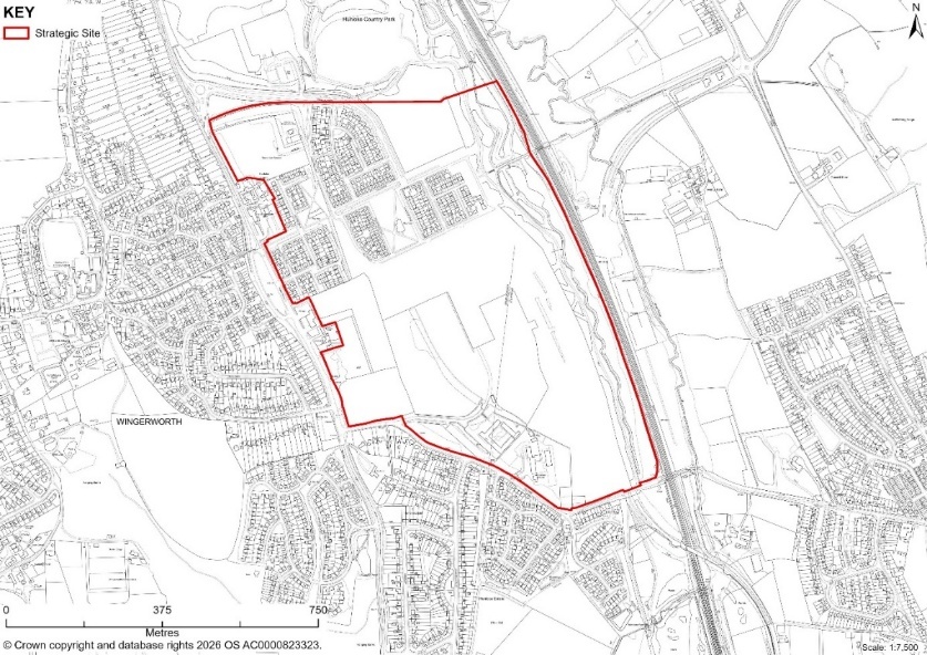
The Avenue site is located to the east of the A61, adjacent to Wingerworth and close to the administrative boundary with Chesterfield Borough. A significant proportion of the site comprises the former Avenue Coking Works which has been subject to a major remediation programme that completed in 2017.
The Avenue site has been allocated for re-development in successive local plans. In 2013 the Council adopted the Avenue Area Strategic Framework as non-statutory planning guidance which is a material planning consideration in determining planning applications on the site. The Framework considered the site capable of delivering around 4-5 hectares of land for B1 (now E(g))[11], B2 and B8 employment uses (in addition to employment uses currently on site) and up to 1100 new homes, along with ancillary facilities and infrastructure, and public open space. Planning permissions are in place for much of the site and include the provision of approximately 700 dwellings with many of these now built out.
The original outline planning permission has since lapsed and further permission is required to develop the employment land included in the original application, alongside the remaining balance of housing envisaged by the original allocation (approximately 400 dwellings). Evidence gathered in the development of this Local Plan has highlighted the presence of high value habitat in parts of the site that remain available for development and it is therefore proposed that a new masterplan for the remaining area of the site is developed before further development comes forward. This will include the requirement to deliver the primary school, for which central government funding has been allocated.
Given the scale of the site, its role in delivering the strategy of the Plan over the plan period and the potential complexities of ensuring that a comprehensive mixed-use development is still achieved on the site, the land is identified as a strategic site. The site is allocated for mixed use development, comprising employment, housing, recreation and open space uses.
The provision of a A61-A617 Avenue link road remains a longer-term aspiration for Derbyshire County Council and the East Midlands County Combined Authority. Whilst it is important that development of the site does not prejudice the construction of a link road from the A61 to A617, currently there is no defined route for this link road. For these reasons a definitive route cannot be safeguarded on the Policies Map, although this provision can feature in the Masterplan Framework required by the allocating policy.
Figure 4.1: Strategic Site Allocation – The Avenue
Policy SS5: The Avenue Comment
- Land at the former Avenue site, as shown on the Policies Map, is allocated as a Strategic Site for mixed use development and must make provision for:
- Approximately 596 dwellings during the Plan period to 2044, incorporating an appropriate mix of house types and tenures, to reflect housing need and market considerations;
- Up to 4 hectares of employment generating uses (falling within use classes E(g).[12]
- A primary school, retail, sport and recreation facilities;
- Protection and/or enhancement of existing open space, sport and recreation facilities;
- Promotion and accommodation of sustainable transport for pedestrians, cyclists, and public transport;
- Effective pedestrian and cycle links to Chesterfield and nearby settlements, including through green infrastructure where this would not have an adverse impact on biodiversity;
- Development of the highest quality design and energy efficiency, with appropriate low carbon technologies following the principles set out in in Policy SDC15 and the Successful Places Design Guide;
- Maintenance and improvement of existing known areas of wildlife habitat and species (including areas of open mosaic habitat) and include measures for habitat creation;
- Appropriate mitigation to prevent unacceptable traffic flow impacts along Mill Lane and the A61; and
- A development that does not prejudice the construction of a link road from the A61 to A617.
- The development will be subject to the production of a Masterplan Framework covering the entirety of the site that remains undeveloped, prior to the submission of a planning application, in order to ensure that all of the above objectives are achieved in a cohesive development that makes efficient use of this brownfield site.
4.14 Former Biwaters Site, Clay Cross Comment
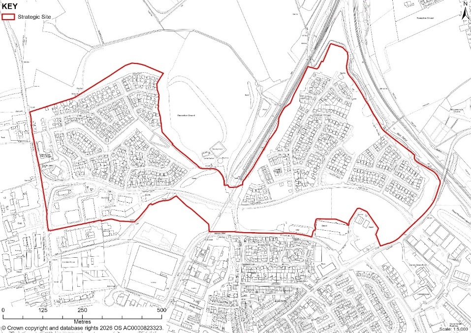
The former Biwaters site is located to the north east of Clay Cross town centre, adjoining Bridge Street Industrial Estate, and is closely related to Coney Green and the residential area between it and the town centre. It is well located in terms of access to services and facilities in Clay Cross. The site also benefits from potential access to the Midland Mainline railway lines to Nottingham and Derby, and access to the M1 via the A6175. Redevelopment of the site is well underway, with the delivery of road infrastructure, a new public house, drive-through outlets, and a retail store at the A61 site entrance.
Approximately 600 dwellings have also been delivered (Phases 1 and 3 built out, phases 2 and 4 almost complete & phase 7 underway). Phases 5a and 9 benefit from planning permission and will contribute a further 148 dwellings to the housing supply in this plan period.
The north eastern part of the site (adjacent the railway line) lies within a high flood risk area, this land will not be built upon, instead a wildlife corridor will be created and buffer zone to ensure minimum standards of flood defence are maintained, in accordance with the NPPF.
The site has been allocated in the Council’s previous two Local Plans covering the periods 2001-2011 and 2014 - 2034. Outline planning permission was first secured for the site in August 2010, and a revised outline planning permission was granted for the site in May 2024 for mixed use development comprising housing, employment generating uses, recreational public open space and highway infrastructure. Whilst the site is largely built out there are a number of critical elements outstanding, requiring the continued inclusion of a strategic policy for the site within the Local Plan. The following elements of the May 2024 permission remain to be provided/completed:
- Phase 5A – 36 dwellings,
- Phase 7 – 9 dwellings,
- Phase 9 – 112 dwellings,
- Local centre,
- Landscaping and Public Open Space, with walking/cycle connectivity, and
- Highway link between A61 and A6175
Figure 4.2: Strategic Site Allocation – Former Biwaters
Policy SS6: Former Biwaters Strategic Site Comment
- Land at Former Biwaters, Clay Cross, as shown on the Policies Map, is allocated as a Strategic Site, for mixed use development. Proposals for the development of the site must:
- Provide a high quality, sustainable, mixed-use development that is well connected and has a functional relationship with Clay Cross;
- Provide approximately 327dwellings within the plan period up to 2044), incorporating an appropriate mix of house types and tenures, to reflect housing need and market considerations;
- Provide an area of publicly accessible open space in the northern portion of the site, incorporating biodiversity enhancements and pedestrian and cycle connectivity to existing development to the north of the site;
- Provide a local centre of 2 hectares in size, comprising local retail and uses falling within use classes E (a-f) and F2, including the provision of non-commercial community meeting space;
- Promote and accommodate sustainable transport for pedestrians, cyclists, and public transport including the provision of a route through the site to provide pedestrian and vehicular access to a future off-site railway station, and provide effective pedestrian access to Tupton Hall School;
- Provide a through road from the A61 to Furnace Hill/A6175;
- Sustain and enhance the significance of heritage assets in particular the Grade 1 listed St Lawrence Church in North Wingfield;
- Provide a wildlife corridor and buffer zone along the River Rother to protect the biodiversity value of the river corridor and protect new development from the risk of flooding, and promote linkages to the wider green infrastructure network;
- Provide structural landscaping, and public open space (including equipped play provision) in accordance with Policies SDC15 and ID9 – 10.
- The development will be subject to the production of a Masterplan Framework, covering the entirety of the site, prior to the submission of a planning application, in order to ensure that all of the above objectives c. - i. are achieved in a cohesive development.
- The Masterplan Framework shall detail the remaining phasing of the development to ensure that the infrastructure (i.e. non-residential and non-commercial floorspace) required by this policy is provided alongside the residential and other development within the allocation.
4.15 Duckmanton Moor Village Comment
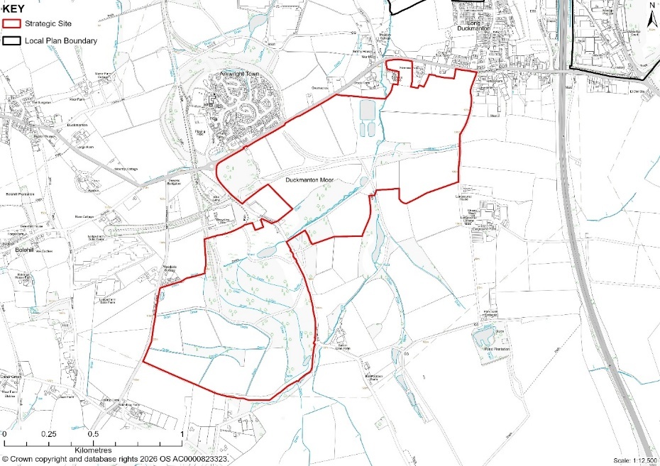
Duckmanton Moor provides an opportunity to create a comprehensively planned new settlement with supporting infrastructure, community facilities, employment opportunities and significant environmental enhancements, ensuring that new development contributes positively to the long-term sustainability of the area.
The site has the capacity to accommodate approximately 2,000-3,000 dwellings alongside employment opportunities, a village centre, community facilities, sports and recreation provision, extensive active travel connections and a new primary school to meet needs arising from future growth. Development will be delivered in phases to ensure that infrastructure and services are provided alongside new homes.
Rather than functioning solely as a housing allocation, the site is intended to create a sustainable new village that can meet a substantial proportion of its day-to-day needs on-site.
A defining feature of the proposal is its landscape-led approach, with substantial green infrastructure, biodiversity enhancement, ecological corridors and a new publicly accessible nature reserve incorporated as integral components of the masterplan. This approach seeks to create a distinctive new settlement that supports sustainable travel choices, responds positively to environmental assets and provides benefits for both new and existing communities.
Together with the other Strategic Growth Locations identified in the Plan, Duckmanton Moor Village will make a significant contribution towards meeting the District's housing and economic development needs whilst supporting the delivery of a sustainable pattern of growth over the Plan period.
Figure 4.3: Strategic Site Allocation – Duckmanton Moor Village
Policy SS7: Duckmanton Moor Village Comment
- Land identified on the Policies as Duckmanton Moor Village is allocated as a Strategic Site for a mixed-use development which must comprise all of the following:
- The provision of up to 3000 dwellings (circa 1300 during the Plan period to 2044) that shall incorporate an appropriate mix of house types and tenures, to reflect identified housing needs in the district including 5%self-build or custom-build dwellings;
- Provision of specialist accommodation for older or disabled people, providing higher levels of care;
- Provision of approximately 2 hectares of employment land (falling within use classes E(g), B2 and B8);
- Provision of a comprehensive site wide blue and green infrastructure strategy that demonstrates the integration of sustainable drainage systems into the layout of the development and measures to restrict surface water run off rates into existing watercourses to an acceptable rate;
- Include a range of local facilities, including a primary school, a local centre, comprising local retail and uses falling within use classes E (a-f) and F2, including the provision of a non-commercial building for community use;
- Recreation space including equipped areas of play and formal sports pitch provision;
- Protect and enhance existing public rights of way through the site;
- Provide high-quality areas of public open space that are effectively integrated into the development through a landscape led approach to the location of development parcels and the inclusion of cycle and pedestrian links between these spaces;
- Provide effective pedestrian and cycle links to Duckmanton, Arkwright Town and Calow, including through green infrastructure features within the site and which connect to suitable crossing facilities on the A632 (to be provided by this development);
- Provide mitigation associated with the trip generation impacts of the development to avoid a severe impact on the capacity of the highway network, including through investment in public transport infrastructure;
- Create development of the highest quality design and energy efficiency, with appropriate low carbon technologies following the principles set out in in Policy SDC15 and the Successful Places Design Guide;
- A development that has a positive interaction with the setting of heritage assets, including but not limited to Sutton Scarsdale Hall (Grade I listed and Scheduled Monument), Bolsover Castle and Registered Park and Garden (Grade I listed and Scheduled Monument.); and
- Maintain and improve existing known areas of wildlife habitat and species (including areas of open mosaic habitat) and include measures for habitat creation and biodiversity enhancement, including creation of a nature reserve.
- The development will be subject to the production of a Masterplan Framework covering the entirety of the site, prior to the submission of a planning application, in order to ensure that all of the above objectives are achieved in a cohesive development. The Masterplan Framework shall:
- detail the phasing of the development to ensure that the infrastructure (i.e. non-residential and non-commercial floorspace) required by this policy is provided alongside the residential and other development within the allocation; and
- be informed by a Landscape and Visual Impact Assessment and a Heritage Assessment and shall demonstrate adequate mitigation of associated impacts; and
- Demonstrate that the design and layout of the development would preserve the wider setting of all affected heritage assets, including but not limited to those listed in part 1(l) of this policy.
4.16 Eckington South Sustainable Urban Extension Comment
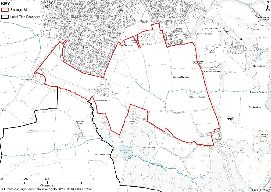
Eckington South provides an opportunity to deliver a comprehensively planned sustainable urban extension to the south of Eckington. The site will create a new mixed-use neighbourhood that is closely integrated with the existing town, providing homes, community facilities, education provision, green infrastructure and supporting transport improvements.
The allocation has capacity to accommodate approximately 2,000 dwellings alongside a new primary school, local centre, community facilities, formal and informal recreation provision, extensive green infrastructure and new walking and cycling connections. Development will be delivered in phases to ensure that homes, infrastructure and community facilities are provided in a coordinated manner.
The site is intended to function as a natural extension of Eckington rather than a standalone housing development. The masterplan will integrate new development with existing neighbourhoods through a network of streets, active travel routes and green infrastructure corridors connecting to Eckington town centre, existing residential areas, allotments, public rights of way and the wider countryside.
A key feature of the proposal is its landscape-led approach, with existing hedgerows, woodland, ponds, watercourses and public rights of way providing the framework for development. Extensive green infrastructure, habitat creation, strategic planting and sustainable drainage will be integrated throughout the site to protect and enhance landscape character, biodiversity and ecological connectivity. The development will also respond positively to the setting of Renishaw Hall, the Renishaw Hall Registered Park and Garden and the Eckington and Renishaw Park Conservation Area through the use of landscape buffers and woodland planting, whilst delivering biodiversity gains and opportunities for recreation and access to nature.
Together with the other Strategic Growth Locations identified in the Plan, Eckington South Sustainable Urban Extension will make a significant contribution towards meeting the District's housing development needs whilst supporting a sustainable pattern of growth over the Plan period.
Figure 4.4: Strategic Site Allocation – Eckington South SUE
Policy SS8: Eckington South Sustainable Urban Extension Comment
- Land identified on the Policies Map as Eckington South is allocated as a Strategic Site for a mixed-use development which must comprise all of the following:
- Provision of approximately 2000 dwellings (circa 1450 during the Plan period to 2044) that shall incorporate a range of sizes and tenures to meet identified needs in the district including 5% self-build or custom-build dwellings;
- Provision of specialist accommodation for older or disabled people, providing higher levels of care;
- Provision of a comprehensive site-wide blue and green infrastructure strategy that demonstrates the integration of sustainable drainage systems into the layout of the development and measures to restrict surface water run off rates into existing watercourses to an acceptable rate;
- Inclusion of a range of local facilities including a primary school, a local centre comprising local retail and uses falling within use classes E (a-g) and F2, including the provision of a non-commercial building for community use;
- Provision of recreation space including equipped areas of play and formal sports pitch provision;
- The existing allotment site (36 plots) shall be retained within the site and integrated into the development in an appropriate and accessible location. Where retention is demonstrated not to be feasible, replacement provision of at least equivalent quantitative and qualitative value shall be provided within the allocation site. The allotments shall be located, accessed and designed so that they are accessible to existing and future users. This shall be made available prior to the loss of the existing allotments.
- Provision of high-quality areas of public open space that are effectively integrated into the development through a landscape led approach to the location of development parcels (including adequate separation retained to the Ancient Woodland adjacent to the southern boundary of the allocation) and the inclusion of cycle and pedestrian links between these spaces;
- Protection and enhancement of existing public rights of way through the site;
- Provision of effective pedestrian and cycle links to Eckington town centre including through green infrastructure throughout the site, connecting to the allotment site to the north and including enhancements to Setcup Lane;
- Provision of a spine road through the site between the eastern and western boundaries of the site (connecting between Staveley Lane and Chesterfield Road);
- Provision of mitigation associated with the trip generation impacts of the development to avoid a severe impact on the capacity of the highway network, including through investment in public transport infrastructure;
- A development that has a positive interaction with the setting of heritage assets, including but not limited to Renishaw Hall (Grade I listed) and Renishaw Registered Park and Gardens (Grade II* listed) to the east of the site;
- Creating development of the highest quality design and energy efficiency, with appropriate low carbon technologies following the principles set out in Policy SDC15 and the Successful Places Design Guide; and
- Maintaining and improving existing known areas of wildlife habitat and species and include measures for habitat creation and biodiversity enhancement.
- The development will be subject to the production of a Masterplan Framework covering the entirety of the site, in order to ensure that all of the above objectives are achieved in a cohesive development. The Masterplan Framework shall:
- detail the phasing of the development to ensure that the infrastructure (i.e. non-residential and non-commercial floorspace) required by this policy is provided alongside the residential and other development within the allocation; and
- be informed by a Landscape and Visual Impact Assessment and a Heritage Assessment and shall demonstrate adequate mitigation of associated impacts; and
- demonstrate that the design and layout of the development would preserve the wider setting of all affected heritage assets, including but not limited to those listed in part 1(l) of this policy.
4.17 Land South of Markham Vale Comment
Land South of Markham Vale comprises approximately 35 hectares of land located immediately south of the existing Markham Vale employment area and adjacent to Junction 29A of the M1 motorway. The site occupies an accessible strategic location at the intersection of the M1, A632 and B6418 and has the potential to contribute towards identified logistics and employment needs within the wider Functional Economic Market Area, building on the established role of Markham Vale as a key employment location
The site has been identified through employment evidence as one of the few available locations capable of accommodating a strategic employment allocation of sufficient scale to meet the needs of the Functional Economic Market Area. The Economic Needs Assessment identifies a requirement for additional strategic logistics sites with excellent access to the strategic highway network and workforce, and the site's location adjoining the existing Markham Vale employment area provides the opportunity to support economic growth, inward investment and job creation.
The allocation site occupies open agricultural land immediately south of Chesterfield Road and forms part of a wider landscape setting that is experienced from a number of important heritage assets, most notably Bolsover Castle. Landscape and heritage assessments undertaken in support of the Local Plan process conclude that development of the site has the potential to result in less than substantial harm to the significance of designated heritage assets through changes to their setting, particularly in relation to Bolsover Castle and associated views across the Doe Lea Valley. The Council therefore recognises that landscape and heritage considerations will be fundamental to the future development of the site and require careful masterplanning, landscape-led design, strategic planting, green infrastructure and the sensitive control of building scale and height.
Given the strategic nature of the allocation and the need to balance economic benefits with environmental considerations, development proposals will be required to be supported by a comprehensive Masterplan Framework covering the entire site. This will ensure that landscape, heritage, ecology, transport, drainage and ground condition considerations are addressed in an integrated manner and that development is delivered as a coordinated, high-quality extension to the existing Markham Vale employment area.
Figure 4.5: Strategic Site Allocation - Land South of Markham Vale
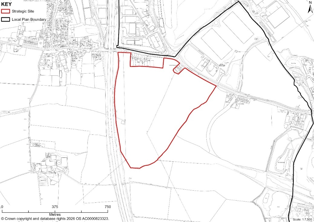
Policy SS9 – Land South of Markham Vale Comment
- Land identified on the Policies Map as Land South of Markham Vale is allocated as a Strategic Employment Site for Strategic Logistics and distribution uses (Use Class B8). Development proposals must comprise all of the following:
- Be designed in a manner which will reduce the impact of the scale and massing of the buildings on the local character of the area, and the amenity of adjacent residential properties;
- Deliver a high-quality landscaped setting within and around the boundary of the development.The assessment must demonstrate how the scheme will respect the character of the landscape, and the setting of heritage assets in particular the Grade I Listed Bolsover Castle;
- Be informed by a detailed Heritage Impact Assessment covering the whole site, to be agreed with the local planning authority in consultation with Historic England, prior to the design of the scheme in order to inform the height of any proposed buildings, layout and extent of the development. The assessment will explicitly include an assessment of the height of any new buildings and impact on the Grade 1 Listed Bolsover Castle as well as detailed consideration of any impacts on other affected designated and non-designated heritage assets and their setting, and subject to the assessment being agreed a programme of informed mitigation to be included with any planning application;
- A detailed Transport Assessment will be required that considers the impact of the scheme, including cumulative impact, on the local and strategic road network including the Junction 29a of the M1 motorway;
- A strategy for the management of surface water utilising sustainable drainage systems must be prepared that reduces the rate of surface water run-off and protects the site itself and the watercourse from flood risk, and which demonstrates how pollutants from the proposed development will be prevented from reaching the River Doe Lea;
- A Noise and Light Pollution Management Plan which includes an appropriate mitigation strategy must be prepared to limit any noise or light pollution to local residents and the wider area;
- include cycle and walking routes through the development, connecting to and enhancing existing cycle and walking infrastructure beyond the boundaries of the site; and
- Provide local training and employment opportunities as part of the construction of the site and during the operational phases of the scheme.
- The development will be subject to the production of a Masterplan Framework covering the entirety of the site, in order to ensure that all of the above objectives a. – g. are achieved in a cohesive development.
4.18 Settlement Development Limits Comment
In addition to the development of sites allocated in the Plan, opportunities will exist throughout the plan period for additional development where it is sustainable development and is appropriate to the scale and function of the settlement in which it is located.
Settlement Development Limits enclose the built framework of settlements identified within the Settlement Hierarchy and determine the extent of the countryside beyond, by taking into account existing, committed and allocated development and land uses. Within Settlement Development Limits identified on the Policies Map the principle of development is acceptable provided it is in line with Policy SS10: Development within defined Settlement Development Limits.
Outside Settlement Development Limits, countryside and/or Green Belt policies apply and all proposals for development will be considered against the requirements set out in Policies SS11: Development in the Countryside & SS12: North East Derbyshire Green Belt. This approach provides certainty to all those involved in the development management process and makes it clear which policies will apply.
This approach complies with the plan-led approach advocated in national policy (NPPF); since the Local Plan identifies sufficient housing provision for the District to meet both a five-year supply of housing on adoption of the Plan and the development requirements for the Plan period. Further land outside Settlement Development Limits is not required to meet this need.
It is acknowledged that in circumstances where the Council may not be able to demonstrate a five-year supply of housing land, these policies may be considered to restrict the supply of housing in terms of the provisions of paragraph 49 of the NPPF. However, these are important place shaping policies that are integral to the strategy of the Local Plan and achievement of sustainable development. Their purpose is to guide development to the right places, rather than constraining development and therefore should be given due weight in decision making in the event that no five-year supply is demonstrated.
Policy SS10: Development within defined Settlement Development Limits Comment
- All development proposals on sites within Settlement Development Limits that are not allocated in the Local Plan or in a Neighbourhood Plan, will be permitted, provided that the proposed development:
- Is appropriate in scale, design and location to the character and function of the settlement; and
- Does not result in the loss of a valued facility or service unless it can be demonstrated that it is no longer viable, or is not the subject of a Community Right to Bid; and
- Is compatible with, and does not prejudice any intended use of adjacent sites and land uses; and
- Accords with other policies of the Plan.
4.19 Development in the Countryside Comment
As a general principle, development will be directed to sites within Settlement Development Limits and allocated sites in accordance with the spatial strategy set out in this Plan. Land outside Settlement Development Limits that is not allocated for development will be treated as countryside.
The countryside makes an important contribution to the character, distinctiveness, biodiversity and economy of the District. It supports agricultural and other land-based businesses, provides opportunities for tourism, recreation and leisure, and is an important resource for local communities. The countryside also supports a range of equestrian activities which make an important contribution to the rural economy and provide opportunities for sport, recreation and leisure. Proposals that support these activities and are appropriately located and designed can contribute positively to the vitality and viability of rural areas.
The Plan seeks to protect the intrinsic character and beauty of the countryside whilst supporting sustainable rural development that contributes to the rural economy and the social wellbeing of rural communities.
The re-use of existing buildings can make a positive contribution to sustainable development by reducing the need for new construction and supporting the efficient use of land and buildings. Many buildings in the countryside, particularly former traditional agricultural buildings, contribute positively to local character and may be capable of supporting a range of alternative uses. However, some buildings are unsuitable for conversion because of their condition, form, construction or location, including where they would be at unacceptable risk from flooding.
Proposals for development in the countryside should be appropriately located and designed to respect the character of the landscape and surrounding area. Development should support the continued vitality of rural communities and the rural economy whilst avoiding unacceptable impacts on the countryside. Development will generally be regarded as appropriate to a countryside location where it supports agriculture, forestry or other land-based rural businesses, rural employment, tourism, recreation, community facilities, rural services, the re-use of existing buildings, or environmental enhancement. Development that does not require a countryside location and could be accommodated more sustainably within a settlement will normally be directed to land within Settlement Development Limits or allocated sites.
Policy SS11: Development in the Countryside Comment
- Outside Settlement Development Limits, and unless otherwise allocated for development in this Plan, proposals that support the vitality of rural communities, the rural economy, the sustainable use of land and buildings, or the enhancement of the natural environment will be supported in principle where they:
- are appropriate to a countryside location;
- respect the intrinsic character, beauty, distinctiveness and tranquillity of the countryside; and
- are of a scale, form and nature that is compatible with their rural setting.
- Development that is considered to be appropriate in principle to a countryside location includes:
- The re-use, regeneration or redevelopment of previously developed land and buildings where the proposal is appropriate to its countryside location;
- The conversion or adaptation of existing buildings in accordance with Policy SDC1;
- Replacement building(s) for the same use that are not materially larger than the building(s) they replace;
- Development required for the operation, expansion or diversification of agriculture, horticulture, forestry and other land-based rural businesses;
- Rural employment development, including business, commercial and industrial uses appropriate to a countryside location;
- Tourism, leisure, recreation and equestrian development where such development is appropriate to its rural setting;
- Visitor accommodation and extensions to existing visitor accommodation in accordance with Policies WC4 and WC5;
- Rural worker accommodation where an essential functional need for a countryside location can be demonstrated in accordance with Policy LC9;
- The provision, expansion or improvement of community facilities, social infrastructure, local services and other development that addresses a demonstrated local need;
- Biodiversity enhancement, habitat restoration, woodland creation, nature recovery, green infrastructure and environmental improvement projects; and
- Development supported through an adopted Neighbourhood Plan.
- All development proposals must be designed and located to conserve and, where possible, enhance:
- Landscape character, local distinctiveness and visual amenity;
- The natural environment, ecological networks, geodiversity and biodiversity interests;
- Heritage assets and their settings;
- The overall quality, character and appearance of the countryside; and
- Residential amenity.
- Development proposals must be integrated into their surroundings through appropriate siting, layout, scale, design, landscaping and use of materials and must not result in unacceptable impacts on highway safety or the capacity of the local road network.
- Where development lies within the Green Belt, the provisions of Policy SS12: North East Derbyshire Green Belt shall also apply.
4.20 North East Derbyshire Green Belt Comment
4.20.1 Purpose of the Green Belt Comment
The fundamental aim of Green Belt policy is to prevent urban sprawl by keeping land permanently open. The essential characteristics of Green Belt are its openness and permanence. Green Belt serves a number of important functions by checking unrestricted sprawl, preventing neighbouring towns from merging into one another, safeguarding the countryside from encroachment, preserving the setting and special character of historic towns and supporting urban regeneration through the recycling of previously developed land.
The North East Derbyshire Green Belt covers a substantial part of the District and forms part of the wider South Yorkshire and North Derbyshire Green Belt. It surrounds the settlements of Dronfield, Eckington and Killamarsh and extends between Sheffield, Chesterfield and the Peak District National Park. The Green Belt has been a longstanding feature of the planning framework in North East Derbyshire and has played an important role in directing development towards sustainable locations and protecting the character and openness of the countryside.
While Green Belt designation has been effective in managing growth and preventing urban sprawl, it also creates significant constraints on development opportunities in some of the District's most sustainable and accessible settlements. Evidence prepared for the Local Plan demonstrates that several settlements with good access to jobs, services and public transport are tightly constrained by Green Belt designation, limiting opportunities to meet identified housing and employment needs in locations where demand is greatest.
4.20.2 Green Belt Review, Grey Belt and Exceptional Circumstances Comment
National policy states that Green Belt boundaries should only be altered where exceptional circumstances are fully evidenced and justified through the preparation or review of a Local Plan. When defining or amending Green Belt boundaries, local planning authorities should ensure that boundaries are capable of enduring beyond the plan period.
In preparing this Local Plan, the Council first considered whether development needs could be accommodated without altering Green Belt boundaries. However, evidence on housing need, employment requirements, site availability, infrastructure capacity and settlement sustainability demonstrated that development requirements could not be accommodated in a manner consistent with the Plan's spatial strategy without a review of Green Belt boundaries.
The Council has undertaken a comprehensive Green Belt Assessment which evaluates the contribution of land parcels to the purposes of the Green Belt and considers the role of land against national guidance. The assessment concludes that the majority of the Green Belt continues to perform an important strategic function and should remain protected. However, the assessment also identifies areas of land that make a limited contribution to Green Belt purposes and which may comprise grey belt land in accordance with national policy.
National policy defines grey belt as land within the Green Belt that does not strongly contribute to the purposes of preventing urban sprawl, preventing neighbouring towns from merging, or preserving the setting and special character of historic towns. Grey belt can also include previously developed land within the Green Belt. The identification of grey belt does not, in itself, indicate that land is suitable for development or that it should be removed from the Green Belt. Decisions on the allocation or release of land must also take account of sustainability considerations, environmental constraints, infrastructure provision, landscape impact and the overall spatial strategy.
The Council's Green Belt Assessment has informed the identification of those locations where limited Green Belt release would cause the least harm to the overall function and integrity of the Green Belt. Sites proposed for allocation have also been subject to detailed site assessment and sustainability appraisal to ensure they represent sustainable development opportunities.
The release of Green Belt land proposed through this Plan represents a small proportion of the overall Green Belt area within the District. The remaining Green Belt will continue to be protected from inappropriate development in accordance with national policy and Policy SS12.
In accordance with national policy, development on land released from the Green Belt should follow the ‘Golden Rules’ and contributeto the beneficial use of the remaining Green Belt through measures such as improved public access, enhanced green infrastructure, landscape enhancement, biodiversity gains, recreational opportunities and the restoration of degraded land.
4.20.3 Safeguarded Land Comment
National policy requires local planning authorities to consider the long-term permanence of Green Belt boundaries. One mechanism for achieving this is the identification of safeguarded land which is removed from the Green Belt to meet longer-term development needs beyond the plan period.
The Council has considered the need for safeguarded land as part of the preparation of this Plan. However, no safeguarded land is proposed due to uncertainties associated with forecasting longer-term development requirements and the absence of robust evidence to justify additional Green Belt release beyond that required to meet identified needs during the plan period. Furthermore, the next Local Plan covering the District is likely to be prepared by the new North Derbyshire Council following implementation of Local Government Reforms. The new unitary authority will cover North East Derbyshire, Chesterfield, Bolsover, Derbyshire Dales, High Peak and part of Amber Valley, creating a much wider geography within which to plan for future development needs.
Policy SS12: North East Derbyshire Green Belt Comment
Green Belt Protection:
- Within the North East Derbyshire Green Belt, as defined on the Policies Map, inappropriate development will not be approved except in very special circumstances, as set out in national policy.
New Buildings:
- The construction of new buildings within the Green Belt will be regarded as inappropriate development unless they fall within one of the exceptions identified in national policy and comply with other relevant policies of the Development Plan. This includes:
- buildings for agriculture or forestry;
- appropriate facilities for outdoor sport, outdoor recreation, cemeteries and burial grounds, and other uses of land that preserve openness and do not conflict with the purposes of including land within the Green Belt;
- the extension or alteration of an existing building, provided it is not disproportionate in size;
- the replacement of an existing building, provided the new building is in the same use and is not materially larger than the building it replaces;
- limited affordable housing for local community needs in accordance with Policy LC4;
- limited infilling in villages;
- limited infilling or the redevelopment of previously developed land, including grey belt land, where the proposal would not cause substantial harm to the openness of the Green Belt or conflict with the purposes of including land within it.
Other Forms of Development:
- The following forms of development will not be regarded as inappropriate development provided they preserve openness and do not conflict with the purposes of including land within the Green Belt:
- mineral extraction;
- engineering operations;
- local transport infrastructure where a Green Belt location is demonstrated to be necessary;
- the re-use of buildings provided they are of permanent and substantial construction;
- material changes of use of land that preserve openness;
- development authorised through a Community Right to Build Order.
Grey Belt:
- Where proposals relate to land identified as grey belt, development proposals will be assessed in accordance with national policy relating to Green Belt and grey belt land. The identification of land as grey belt will not, in itself, establish the principle of development. Proposals must:
- accord with the spatial strategy and other policies of the Local Plan; and
- appropriately address any environmental, landscape, heritage, biodiversity, flood risk or other infrastructure constraints.
Green Belt Enhancements:
- Development proposals constituting major development on land released from the Green Belt will be expectedto contribute to the beneficial use and environmental enhancement of the remaining Green Belt adjacent to the site through measures such as improved public access, green infrastructure, biodiversity enhancement, landscape improvement and recreational opportunities.
4.21 Local Settlement Gaps Comment
The distinct identity, character and setting of North East Derbyshire's towns and villages are important elements of the District's spatial structure and contribute to the creation of sustainable, attractive and distinctive places. The District's varied landscape, rolling topography and often closely related pattern of settlements mean that undeveloped land between settlements frequently plays an important role in maintaining their separate identity, preventing coalescence and preserving important views and landscape settings.
The 2026 Local Settlement Gap Study found that pressures on settlement identity and separation are likely to increase over the Plan period as a result of higher housing and employment requirements, ongoing regeneration, and changes to national planning policy, including Green Belt policy. The study also confirmed that maintaining settlement identity remains a valid planning objective and that Local Settlement Gaps provide an appropriate local policy mechanism for recognising and safeguarding those areas that make an important contribution to settlement separation, landscape setting and sense of place.
Local Settlement Gaps have therefore been identified on the Policies Map where evidence demonstrates that land performs an important role in maintaining the physical, visual or perceptual separation between settlements, preserving their individual character, or protecting distinctive landscape settings and important views. In many cases these areas also provide wider benefits through public access, recreation, green infrastructure, biodiversity and landscape character.
The designation of a Local Settlement Gap does not prevent all forms of development. Rather, it ensures that significant weight is given to the importance of maintaining settlement identity, separation and landscape character when considering development proposals. The identified Local Settlement Gaps have been defined as the minimum area necessary to fulfil these functions and have been informed by detailed assessment of settlement form, topography, landscape character, existing development patterns and environmental constraints.
The Council is satisfied that the Local Settlement Gap designations do not undermine the delivery of the Plan's development strategy or the ability to meet identified housing and employment needs. Instead, they support a more sustainable pattern of growth by directing development to appropriate locations whilst protecting those areas that are most important to maintaining the distinct identity and character of North East Derbyshire's communities.
Policy SS13: Local Settlement Gaps Comment
- Within those areas identified on the Policies Map as Local Settlement Gaps, development proposals will only be permitted where they:
- Maintain the physical, visual and perceptual separation between settlements;
- Preserve the distinct identity and setting of historically separate settlements; and
- Maintain the undeveloped character and openness of the Local Settlement Gap.
The Key diagram summarises the key elements of the Spatial Strategy across the District.
Figure 4.6: Key Diagram
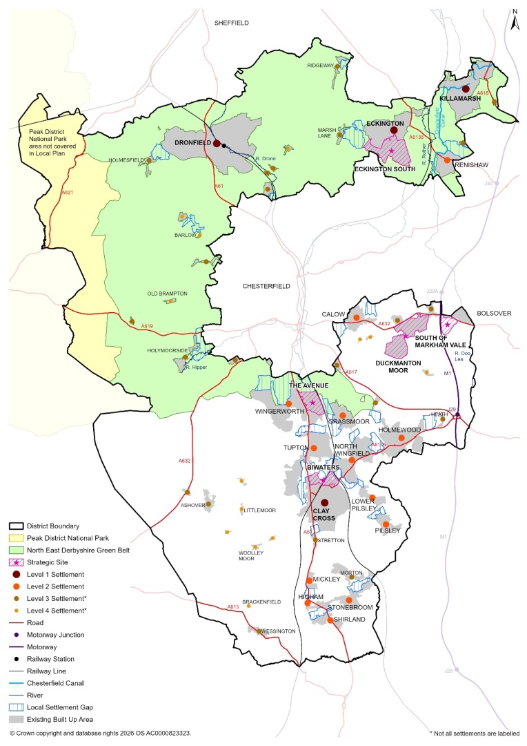
[3] Planning & Compulsory Purchase Act 2004 (S.39).
[4] E.g: Householder applications, Listed Building Consent, Prior Notifications, Lawful Development Certificates, Applications for Works to Trees
[5] Exceptions are: Householder applications, Listed Building Consent, Prior Notifications, Lawful Development Certificates, Applications for Works to Trees
[7] Measure of life expectancy difference between the most and least deprived areas.
[9] This is a different base date to the Local Plan as the Economic Needs Assessment calculated employment land requirements 2022-2024.
[10] Figures are based upon completions since 2024, commitments and allocations. These figures can be used to inform Neighbourhood Plans.
[11] The AASF predates the The Town and Country Planning (Use Classes) (Amendment) (England) Regulations 2020, which deletes the B1 (Business) Use Class and incorporates those uses (offices, research & development and other industrial uses appropriate to a residential area) within category g of a broader use Class E – Commercial, Business and Service Uses.
[12] This includes employment uses already delivered and in use
