
1. Publication Draft North East Derbyshire Local Plan 2024 - 2044 (Reg 19)
Other elements in this consultation
2 Spatial Portrait Comment
2.1 Description of the Area Comment
North East Derbyshire covers an area of 276 square kilometres. According to the latest ONS mid-year population estimates the District has a population of 106,646[1] people. It forms part of the North Derbyshire and Bassetlaw Housing Market Area (HMA), together with Bolsover, Bassetlaw and Chesterfield Borough; originally identified in 2008 through the evidence on the East Midlands Regional Spatial Strategy. Because of its geographical position on the border of North Derbyshire and South Yorkshire the District has strong economic relationships with both Derbyshire and Nottinghamshire and South Yorkshire. The district forms a part of the East Midlands Combined County Authority, the economic area covering Derbyshire and Nottinghamshire, and adjoins the South Yorkshire Mayoral Combined Authority in the north.
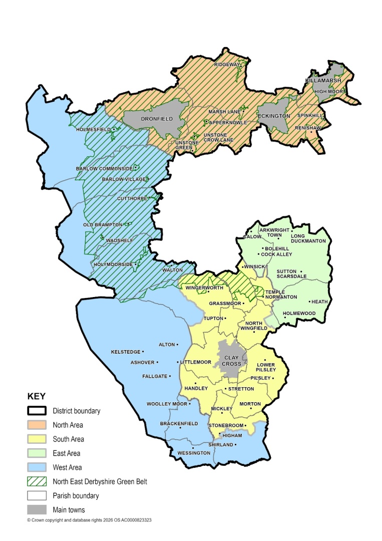
The District wraps around Chesterfield and adjoins five other local authority areas including Amber Valley to the south, Derbyshire Dales to the west, Bolsover to the east, and Sheffield City, and the Borough of Rotherham to the north. The west of the District is largely rural and forms part of the eastern edge of the Peak District National Park which is a local planning authority in its own right. The area covered by the North East Derbyshire Local Plan is that part of North East Derbyshire which falls outside the Peak District National Park. Figure 2.1 shows the Local Plan area and the district’s relationship with other nearby towns and cities within other local authority areas which it has been important to work closely with on cross-boundary strategic matters- see Chapter 1.
The District comprises the four main towns of Clay Cross, Dronfield, Eckington and Killamarsh, together with a number of large and small villages, and hamlets set within attractive countryside settings. The four towns have important roles to play in providing the economic and social hearts of communities in North East Derbyshire, and are home to about 50% of the population. Clay Cross is located in the south of the District, whilst Dronfield the district’s largest town, and Eckington and Killamarsh are located in the north. Outside of these towns 42% of the district’s population live within larger villages with a good range of facilities, whilst the remaining 8% are scattered within the district’s other smaller settlements.
North East Derbyshire, being located in the centre of the country, has good accessibility to high-quality transport links, with the M1 motorway junctions 29, 29a and 30 lying to the east of the District, providing communities and businesses with access to the motorway. It also has the Midland Mainline running through it. Whilst Dronfield is the only one of the four towns in the district with a railway station, Chesterfield, with fast and direct rail connections to Nottingham, Derby, Leicester, and London to the south, is easily accessible to residents and businesses. In addition, the Midland Mainline from Chesterfield provides access to cities in the north of England such as Sheffield and Leeds.
In broad terms, North East Derbyshire can be subdivided into four distinct areas. These areas display close physical and functional relationships, each having their own characteristics and development needs to be addressed in the Local Plan. The four areas are outlined graphically on Figure 2.1 and described in more detail below.
2.1.1 Northern Area Comment
The north of the District contains three of the District’s four towns; Dronfield, Eckington, and Killamarsh, and a number of much smaller settlements surrounded by countryside comprising mainly of wooded hills and valleys. The rural area lies entirely in the Green Belt and the towns and other settlements have generally been developed up to their boundaries, meaning that there are few development sites still available within their existing built-up areas. All three towns have a coal mining history, although there is little evidence of that today. Each of these towns has its own designated town centre, which in the main are relatively successful in terms of local shopping and service provision. These towns relate closely to the Sheffield conurbation and just under a quarter of people commute out of the District to work in the city.
2.1.2 Southern Area Comment
The south of the District contains the town of Clay Cross and a close grouping of other former mining settlements that includes Grassmoor, North Wingfield, Tupton, Wingerworth, and Pilsley. Set within open countryside these settlements have a strong sense of identity and community which is characterised by the important open areas between them. Clay Cross has seen major regeneration in recent years in and around the town centre, along with the re-development of the former Biwaters site, an important strategic site that has been substantially built out providing new homes, community facilities and infrastructure. Current flagship projects such as the expansion of the town centre through the Baileys Square development, alongside the existing health and wellbeing facility at Clay Cross Active will provide the facilities required to accommodate a growing population in the area. A further strategic site at the Former Avenue site has also delivered s significant number of homes, with more homes, employment and infrastructure (including a new primary school still to be delivered).
2.1.3 Eastern Area Comment
The east of the District contains communities and employment locations which are strongly linked with Chesterfield and the M1 motorway, including Holmewood, Calow, Long Duckmanton, and Temple Normanton. The area contains the business and distribution park with Enterprise Zone status at Markham Vale. Sutton Scarsdale Hall, a Grade I listed Georgian ruined stately home, is located in the east of the District, and the settings of Bolsover Castle and Hardwick Hall, both within Bolsover, have cross boundary implications in the east of the District. It will be important that any new development in the east takes this into account and is sensitive to the need to protect these designated heritage assets.
2.1.4 Western Area Comment
The west of the District lies on the edge of the Peak District National Park and is particularly attractive including some of the finest Derbyshire landscape outside of the National Park. The area contains a number of villages and farms set in a rural backdrop of dark millstone grit that has provided the stone for many of the buildings.
A key feature that gives the District its distinctive character is the green space that separates and links its towns and villages. Local people have already identified the importance of this green space and a key feature of the Strategy will be to protect and enhance the most important areas and ensure that opportunities to access this countryside are increased. The District also has a number of other important historic and environmental assets that play a crucial role in characterising its urban and rural areas. These include listed buildings and conservation areas as well as a large number of important sites for nature conservation.
There are 23 parish councils and one town council located within the District. A number of these parish and town councils have neighbourhood plans. These Plans cover parts of the district, including Ashover, Brackenfield, Brampton, Dronfield, Holymoorside and Walton, Shirland, Wessington and Wingerworth, and form part of the development plan for their respective areas where they have been made, and should therefore be read alongside the Local Plan.
Figure 2.1: North East Derbyshire District - Areas
2.2 Issues Comment
Drawing on the demographic data and information related to the District and its communities detailed within the Authority Monitoring Report, the Sustainability Appraisal, and other evidence base documents there are a range of important issues in the area that the Local Plan will seek to plan positively for or help to address. Whilst some of the issues identified are relevant at national and regional levels, the list includes both positive and negative attributes and focuses on specific issues relevant to North East Derbyshire. These key issues which are not ranked in any particular order of priority or importance are set out below:
2.2.1 Population Comment
North East Derbyshire, in common with many other areas, is experiencing an ageing population. This will have implications for certain types of housing and other infrastructure such as access to the health service provision. It also means there is a need to provide more family and affordable housing and job opportunities to attract and retain younger people which will serve to re-balance the district’s population profile.
2.2.2 Settlements and Separation Comment
The District contains four main towns together with a number of other large and small settlements set within attractive countryside and landscapes which are highly valued locally.
Within the existing built up areas of settlements past development has gradually taken up most development opportunities including on previously developed land. Consequently, there will inevitably have to be some loss of countryside to meet the district’s development needs.
Across the south of the District the settlement pattern is characterised by a number of large villages and the town of Clay Cross. Some of these settlements lie in relatively close proximity to one another and in certain areas development has led to their coalescence such that their individual identity and the sense of separation between them is a cause for concern.
In the north of the District lie the towns of Dronfield, Eckington and Killamarsh. Given that these towns are surrounded by Green Belt, there are issues in balancing the housing needs of these specific areas against the impact on the Green Belt and the countryside.
2.2.3 Housing Comment
North East Derbyshire has a significant need for new houses across the District to support a range of different households. The Housing Needs Study 2024 identifies demand for a mix of dwelling sizes and tenures, including affordable homes, family housing, smaller homes for first-time buyers, and bungalows. There is also an identified need to support self and custom build housing, build-to-rent development and accommodation for specific groups, helping to create balanced and inclusive communities and widen housing choice across the District.
Housing affordability remains a significant challenge across the District. Evidence indicates that 24% of newly-forming households are unable to afford to rent or buy a home, whilst 71% of households are unable to purchase a property without financial assistance. Limited savings for deposits, together with wider affordability pressures, continue to restrict access to home ownership for many residents.
The population of North East Derbyshire is ageing, with the number of residents aged over 65 projected to increase by around 24% between 2022 and 2044. As a result, there is a growing need for accessible and adaptable homes, specialist older persons accommodation, and housing with care and support.
2.2.4 Economy & Employment Comment
The District has a low jobs density and there is a need to provide employment locally in order to provide the opportunity for people to work close to where they live.
The retains a significant manufacturing sector, however there is a need to diversify the local economy to create jobs in growth sectors such as advanced manufacturing, logistics and knowledge-based sectors.
North East Derbyshire has average wage levels typically in line with the regional average but below the national level, and a lower proportion of the workforce with higher level qualifications when compared with regional and national averages.
Unemployment is high in some parts of the district, including within Grassmoor, North Wingfield and Clay Cross north and south wards.
There is potential to capitalise on the district’s tourism and visitor economy given its location on the edge of the Peak District National Park and its close proximity to a number of other important tourism attractions. These include existing ones such as Chatsworth House, Hardwick Hall, Bolsover Castle, Renishaw Hall, and the potential new major leisure and visitor resorts being planned on the Birchall Estate known as Peak Resort near Unstone in Chesterfield Borough.
2.2.5 Town Centres Comment
The town centres of Clay Cross, Dronfield, Eckington and Killamarsh are all in need of continued support and investment to build upon their strengths, and to help sustain and regenerate them into the future.
Recent Town Centre Health Checks identify that the district’s centres continue to perform an important retail, service, community and leisure function, but also highlight several challenges facing centre. While vacancy rates are generally low and centres continue to attract a range of businesses and community uses, the Health Checks identified pressures arising from changing shopping habits, limited leisure and evening economy provision in some locations, competition from online retailing, and the need for continued public realm and accessibility improvements. The Health Checks provide an important evidence base for monitoring the vitality and viability of centres over time, informing future planning policy, regeneration initiatives and investment priorities.
Elsewhere across the District there is a range of smaller local centres which need continued support to sustain their role as day-to-day shopping destinations.
2.2.6 Deprivation Comment
Although not a major issue across North East Derbyshire, the Index of Multiple Deprivation shows that there are pockets of deprivation. The English Indices of Deprivation 2025[2] indicate that approximately 13% of the district’s population, around 13,500 residents, live in neighbourhoods within the 20% most deprived nationally, including approximately 4% living in neighbourhoods within the most deprived 10%. Residents living in these more deprived areas can experience challenges and disadvantages associated with low income, low employment, poor education and health, crime, and barriers to housing and services. At the same time, around 15% of the district’s population lives within neighbourhoods in the least deprived 10% nationally, demonstrating the contrasting socio-economic conditions found across North East Derbyshire. The spatial concentration of disadvantage supports a targeted approach to regeneration, infrastructure, service provision and measures intended to reduce inequalities.
2.2.7 Health Comment
Although overall health outcomes in North East Derbyshire compare reasonably well with national averages in some areas, significant health inequalities remain between communities. People living in more deprived areas typically experience poorer health outcomes, lower healthy life expectancy and spend a greater proportion of their lives in poor health than those living in less deprived areas. These inequalities are closely linked to wider determinants of health, including income, employment, housing quality, education, access to services and lifestyle factors.
Health challenges in the District include lower levels of physical activity, higher levels of obesity, higher rates of musculoskeletal conditions and diabetes, increased emergency hospital admissions due to falls amongst older people, and higher levels of alcohol-related harm than the national average. Female life expectancy inequality at birth is also greater than the England average, demonstrating that health outcomes can vary significantly between different communities within the District.
Addressing these health inequalities requires a coordinated approach which supports healthy lifestyles, access to healthcare and community facilities, opportunities for walking and cycling, access to green infrastructure and open space, and the delivery of healthy and inclusive places.
2.2.8 Accessibility and Transport Comment
North East Derbyshire is well located in relation to other major centres of population and has good access to national road and rail networks due to its proximity to Junctions 29, 29a and 30 of the M1 motorway, and stations on the Midland Mainline.
Traffic congestion is an issue at specific locations in the District especially along the A61 corridor which can become congested during busy periods, particularly if there are problems on the M1.
Bus services are relatively frequent within the main towns, but patchier and more infrequent in the more rural parts of the district.
Dronfield is the only town with a railway station. Elsewhere residents and business have access to the railway station at Chesterfield that provides good services both to London and the north of the country.
2.2.9 Infrastructure Comment
New development will generate a need for new or improved infrastructure and solutions will be needed, in consultation with infrastructure providers, to enable future development needs to be accommodated.
The District contains a network of green and blue infrastructure assets that are important for their recreation, landscape and biodiversity value, and which require safeguarding and improving for future generations to enjoy. There are significant opportunities to improve linkages between areas of open space, parks and the wider countryside.
2.2.10 Climate Change and Flooding Comment
Although the risk of flooding is not widespread it is a constraint to development in certain locations at the district’s main towns and some of the larger villages including North Wingfield, Grassmoor and Wingerworth.
Ensuring that development contributes towards reducing flood risk through its location, design and layout by improvements to drainage infrastructure and the use of sustainable drainage systems will be a priority.
There are opportunities to increase the capacity of renewable energy generation in the district to help reduce emissions and climate change.
2.2.11 Water, Air and Soil Quality Comment
Improvements in water quality in the district are required to meet the standards required by the Water Framework Directive.
The development of new and improved infrastructure to accompany growth has the potential to lead to an increase in soil erosion and soil loss.
Overall air quality is good in North East Derbyshire. Although the more densely populated areas in the east of the district and close to the M1 motorway have the highest levels of air pollution, no Air Quality Management Areas are currently, or anticipated to be declared in the District during the plan period.
2.2.12 Natural Environment Comment
A significant number of protected sites and species are present in North East Derbyshire.
The District’s landscape is one of contrast and diversity. Woodland, hilly pastures, green dales and waterways all contribute to the District’s landscape, making it unique from other areas across the country. There are potential effects on the integrity of the district’s landscape.
Growth will place pressures and heighten the need to protect and enhance the district’s wealth of natural environment assets.
2.2.13 Built Environment Comment
There is a wealth of heritage assets and archaeological remains across the District that adds to the character of the area and which is in need of long term protection and management to maintain its long term future.
Good design is a key aspect of achieving sustainable development in North East Derbyshire and new development should positively respect the area’s local distinctiveness and sense of place through its design especially in regard to heritage assets.
Archaeological remains, both seen and unseen which have the potential to be affected by growth and development in North East Derbyshire will need to be protected and where possible enhanced to secure their long term future.
[1] Office for National Statistics (2024), using 2021 Census data and newer non-Census data
