NEDDC Local Plan Issues and Options Consultation on the Strategic Approach to the Location of Development and Refined Sites (March 2026)
Priority 4 – Level 4 Settlements – Very Small Villages/Hamlets
Barlow Commonside
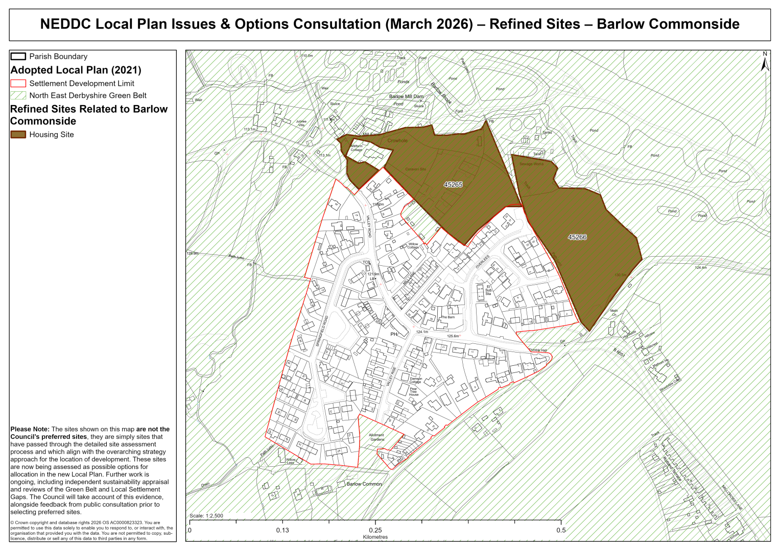
45265 – Land to the East of Valley Road, Barlow Commonside
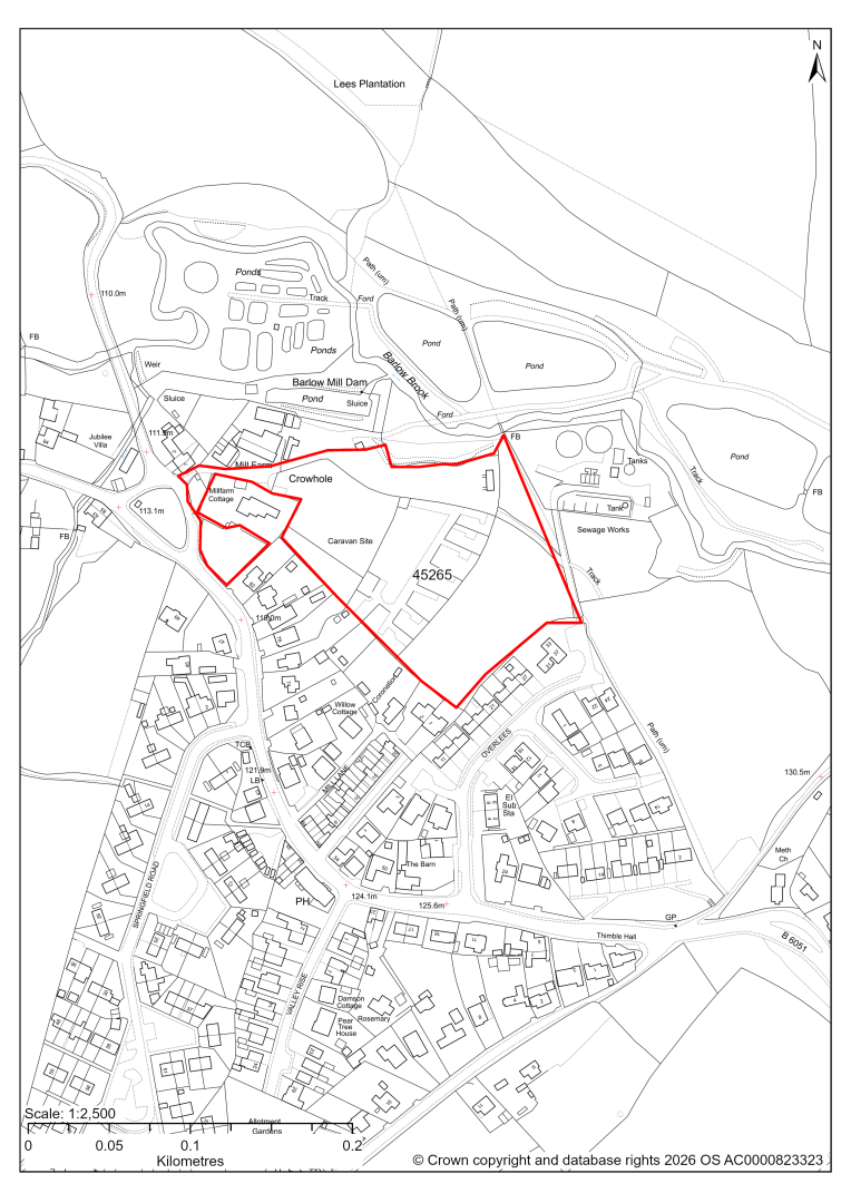
45265 – Land to the East of Valley Road, Barlow Commonside
- This site may be able to support approximately 60 dwellings, based on prevailing neighbouring densities. Mitigation measures have not been applied to this site capacity yet and may result in an altered total.
- The site is located within the Green Belt and will be assessed through a new Green Belt Review to identify the extent to which the site meets Green Belt purposes a, b & d (related to checking unrestricted sprawl, preventing neighbouring towns merging and preserving the setting and special character of historic towns). The review will identify whether the site is Grey Belt and will inform decisions over whether, or not, Green Belt boundaries should be amended to account for development needs – as required by the National Planning Policy Framework (2024).
- For information, the 2016/17 Green Belt Review showed that this site (which lies within GB land parcel: BARC/GB/001) performed moderately against Green Belt purposes a & d and weaker against purpose b. Please note: the new Green Belt Review will follow the detailed methodology set out in recent National Planning Practice Guidance, which differs to the approach taken in the 2016/17 review, in terms of assessment criteria and what can be considered to be a town). For this reason, the land parcel results may differ.
- Development on the site may have a moderate landscape impact.
- The western edge of the site is located within the Conservation Area.
- Archaeological assessment classifies the site as having archaeological/historic environment issues, but might be suitable for allocation with appropriate site specific policy.
- Ecology assessment finds a moderate impact. The site adjacent to a Local Wildlife Site. There would need to be suitable buffers between development and the Bar Low Brook.
- Highway access may need to be confirmed further.
- Less than 0.5% on the northern most edge of the site falls within flood risk zone 3. There is also some risk of surface water flooding on the site.
- The site is located within coal authority development high risk area.
If this site were to be taken forward as an allocation, mitigation measures for the above constraints will need to be considered and any Local Plan policy text should include the requirement to address and mitigate the constraints listed above.
45266 – Land to the North of Millcross Lane, Barlow
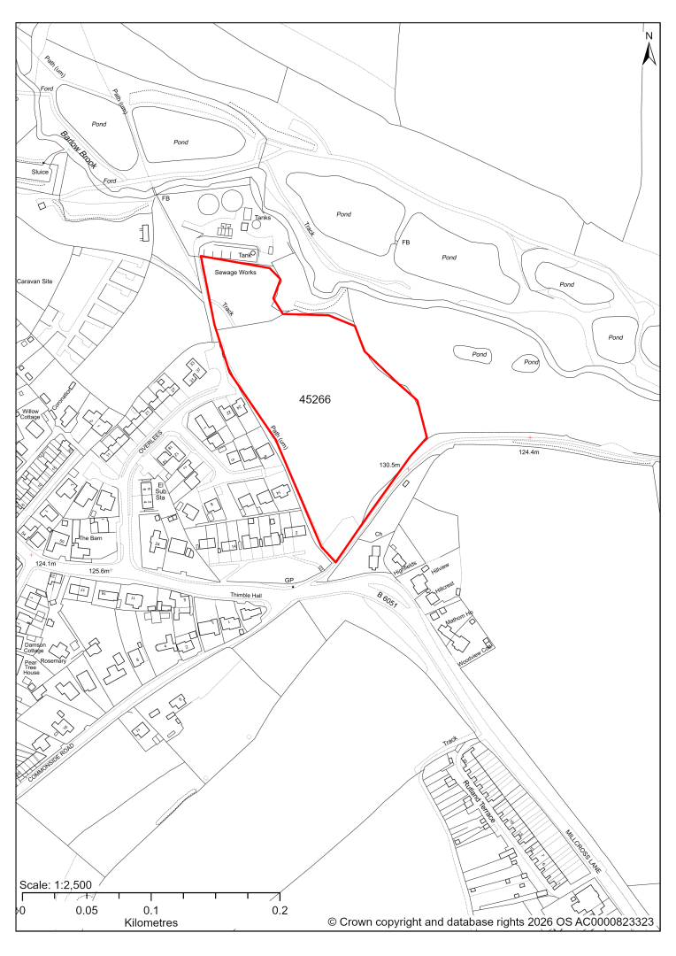
45266 – Land to the North of Millcross Lane, Barlow
- This site may be able to support approximately 50 dwellings, based on prevailing neighbouring densities. Mitigation measures have not been applied to this site capacity yet and may result in an altered total.
- The site is located within the Green Belt and will be assessed through a new Green Belt Review to identify the extent to which the site meets Green Belt purposes a, b & d (related to checking unrestricted sprawl, preventing neighbouring towns merging and preserving the setting and special character of historic towns). The review will identify whether the site is Grey Belt and will inform decisions over whether, or not, Green Belt boundaries should be amended to account for development needs – as required by the National Planning Policy Framework (2024).
- For information, the 2016/17 Green Belt Review showed that this site (which aligns with GB land parcel: BARC/GB/003) performed strongly against Green Belt purpose a, moderately against purpose b and weaker against purpose d. Please note: the new Green Belt Review will follow the detailed methodology set out in recent National Planning Practice Guidance, which differs to the approach taken in the 2016/17 review, in terms of assessment criteria and what can be considered to be a town). For this reason, the land parcel results may differ.
- Development on the site may have a moderate landscape impact.
- Desktop ecology advice finds a medium impact level of development upon biodiversity in the east of the site, closest to the neighbouring Local Wildlife Site. A site visit will be needed in the spring.
- Highway access may need to be confirmed further.
- There is some risk of surface water flooding on the site.
- The site is located within coal authority development high risk area.
If this site were to be taken forward as an allocation, mitigation measures for the above constraints will need to be considered and any Local Plan policy text should include the requirement to address and mitigate the constraints listed above.
Old Brampton
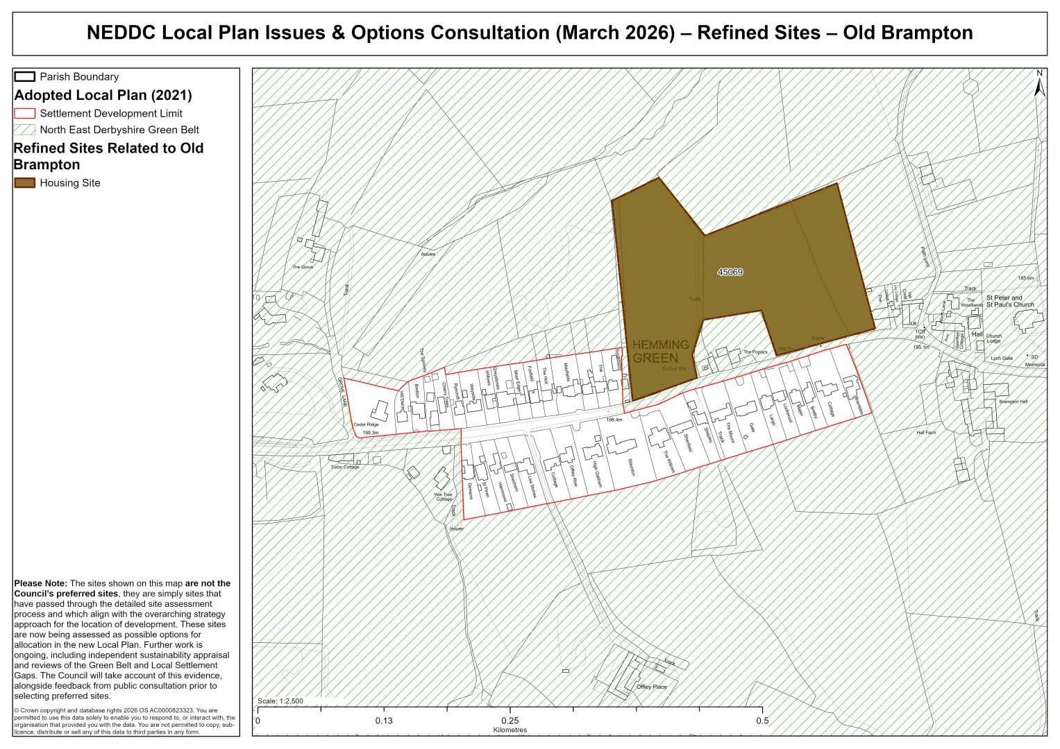
45069 – Land to the North of Hemming Green, Old Brampton
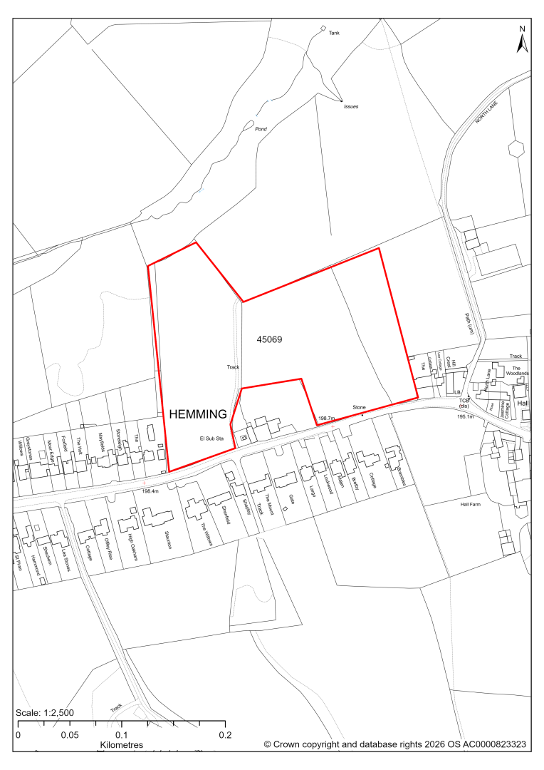
45069 – Land to the North of Hemming Green, Old Brampton
- This site may be able to support approximately 50 dwellings, based on prevailing neighbouring densities. Mitigation measures have not been applied to this site capacity yet and may result in an altered total.
- The site is located within the Green Belt and will be assessed through a new Green Belt Review to identify the extent to which the site meets Green Belt purposes a, b & d (related to checking unrestricted sprawl, preventing neighbouring towns merging and preserving the setting and special character of historic towns). The review will identify whether the site is Grey Belt and will inform decisions over whether, or not, Green Belt boundaries should be amended to account for development needs – as required by the National Planning Policy Framework (2024).
- For information, the 2016/17 Green Belt Review showed that this site (which aligns with GB land parcel: OBRAM/GB/003) performed strongly against Green Belt purpose a and moderately against purposes b & d. Please note: the new Green Belt Review will follow the detailed methodology set out in recent National Planning Practice Guidance, which differs to the approach taken in the 2016/17 review, in terms of assessment criteria and what can be considered to be a town). For this reason, the land parcel results may differ.
- Development on the site may have a moderate landscape impact. The site would constitute a significant increase in the overall size of Old Brampton. A smaller area may be more suitable.
- Archaeological assessment classifies the site as having archaeological / historic environment issues, but might be suitable for allocation with appropriate site specific policy. The site is adjacent to the Conservation Area, and close to the church and hall.
- Ecology assessment finds a moderate impact. The site adjacent to two Local Wildlife Sites and ancient woodland. Indirect impacts on these sites are possible. There would need to be suitable buffers between development and the Local Wildlife Sites and ancient woodland.
- Highway access may need to be confirmed further.
- Natural England’s provisional agricultural land classification of the area is grade 3.
- The site is located within coal authority development high risk area.
If this site were to be taken forward as an allocation, mitigation measures for the above constraints will need to be considered and any Local Plan policy text should include the requirement to address and mitigate the constraints listed above.