NEDDC Local Plan Issues and Options Consultation on the Strategic Approach to the Location of Development and Refined Sites (March 2026)
Priority 1 – Edge of Chesterfield/Sheffield, New Settlement/Strategic Sites and Level 1 Settlements – Main Towns
Edge of Sheffield
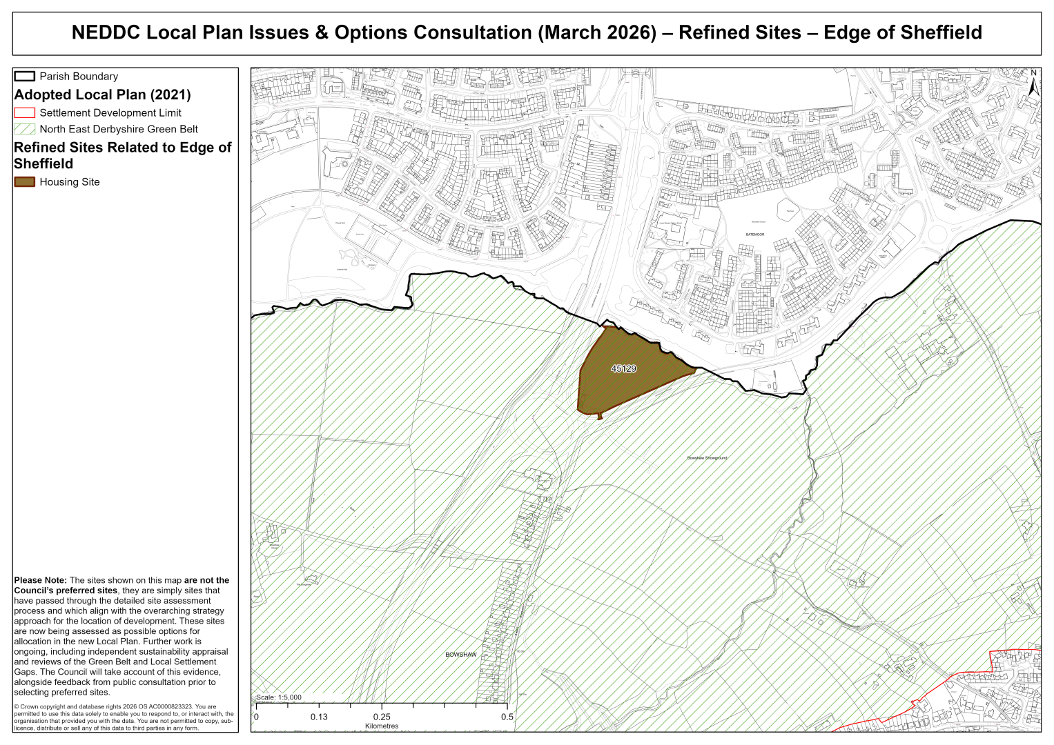
45129 – Land between Jordanthorpe Parkway (B6057) and Chesterfield Rd South (A61), Jordanthorpe, Sheffield
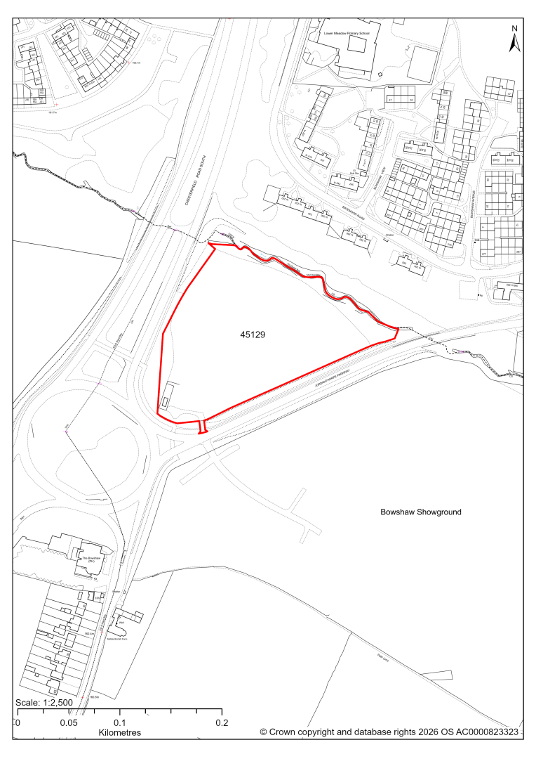
45129 – Land between Jordanthorpe Parkway (B6057) and Chesterfield Rd South (A61), Jordanthorpe, Sheffield
- This site may be able to support approximately 200 dwellings, based on prevailing neighbouring densities, and a 20% density uplift for towns and cities. Mitigation measures have not been applied to this site capacity yet and may result in an altered total.
- The site is located within the Green Belt and will be assessed through a new Green Belt Review to identify the extent to which the site meets Green Belt purposes a, b & d (related to checking unrestricted sprawl, preventing neighbouring towns merging and preserving the setting and special character of historic towns). The review will identify whether the site is Grey Belt and will inform decisions over whether, or not, Green Belt boundaries should be amended to account for development needs – as required by the National Planning Policy Framework (2024).
- For information, the 2016/17 Green Belt Review showed that this site (which covers the entirety of GB land parcel DRO/GB/005) performed moderately against Green Belt purpose a, strongly against purpose b and weakly against purpose d. Please note: the new Green Belt Review will follow the detailed methodology set out in recent National Planning Practice Guidance, which differs to the approach taken in the 2016/17 review, in terms of assessment criteria and what can be considered to be a town). For this reason, the land parcel results may differ.
- Highway access may need to be confirmed further. There is a level difference between Jordanthorpe Parkway and the site. Access from Chesterfield Road would be less steep, but would require those approaching the site from south east and those exiting the site to use the roundabouts to turn around.
- Approximately 5% of the site is covered by flood risk zones 2 and 3, along the watercourse at the northern boundary of the site.
- There is an existing telecoms substation on site.
- Natural England’s provisional agricultural land classification of the area is grade 3.
If this site were to be taken forward as an allocation, mitigation measures for the above constraints will need to be considered and any Local Plan policy text should include the requirement to address and mitigate the constraints listed above.
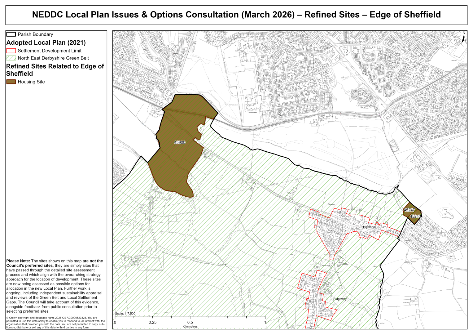
45243 – Land North East of High Lane, Ridgeway, Sheffield
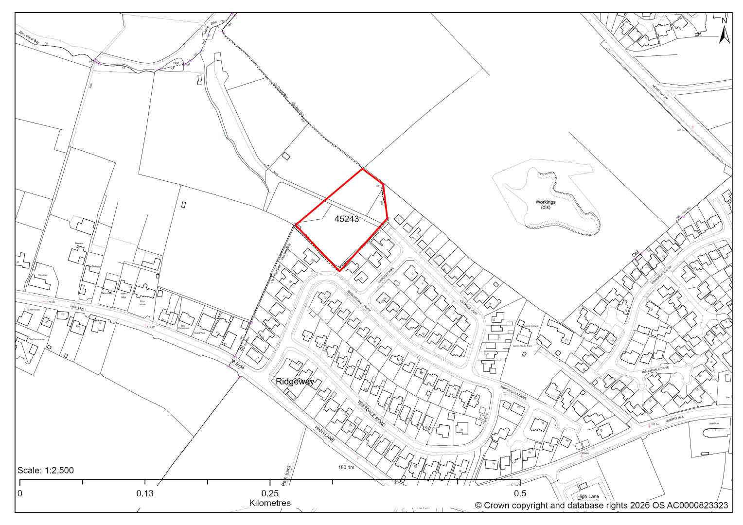
45243 – Land North East of High Lane, Ridgeway, Sheffield
- This site may be able to support approximately 12 dwellings, based on prevailing neighbouring densities, and a 20% density uplift for towns and cities. Mitigation measures have not been applied to this site capacity yet and may result in an altered total.
- The site is located within the Green Belt and will be assessed through a new Green Belt Review to identify the extent to which the site meets Green Belt purposes a, b & d (related to checking unrestricted sprawl, preventing neighbouring towns merging and preserving the setting and special character of historic towns). The review will identify whether the site is Grey Belt and will inform decisions over whether, or not, Green Belt boundaries should be amended to account for development needs – as required by the National Planning Policy Framework (2024).
- For information, the 2016/17 Green Belt Review showed that this site (which lies within a smaller part of GB land parcel: RID/GB/002) performed strongly against Green Belt purposes a & b and moderately against purpose d. Please note: the new Green Belt Review will follow the detailed methodology set out in recent National Planning Practice Guidance, which differs to the approach taken in the 2016/17 review, in terms of assessment criteria and what can be considered to be a town). For this reason, the land parcel results may differ.
- The site is located within the Moss Valley Conservation Area.
- Highway access may need to be confirmed further, in relation to the utility pole restricting access to accommodate two-way vehicles movement, and any potential ransom strip.
- There is some risk of surface water flooding on the site.
- There is some overlap with Sheffield’s Air Quality Management Area.
- Natural England’s provisional agricultural land classification of the area is grade 3.
- The site is located within coal authority development high risk area.
If this site were to be taken forward as an allocation, mitigation measures for the above constraints will need to be considered and any Local Plan policy text should include the requirement to address and mitigate the constraints listed above.
45247 – Land North East of High Lane, Ridgeway, Sheffield
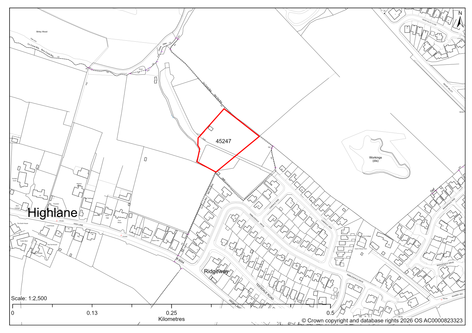
45247 – Land North East of High Lane, Ridgeway, Sheffield
- This site may be able to support approximately 13 dwellings, based on prevailing neighbouring densities, and a 20% density uplift for towns and cities. Mitigation measures have not been applied to this site capacity yet and may result in an altered total.
- The site is located within the Green Belt and will be assessed through a new Green Belt Review to identify the extent to which the site meets Green Belt purposes a, b & d (related to checking unrestricted sprawl, preventing neighbouring towns merging and preserving the setting and special character of historic towns). The review will identify whether the site is Grey Belt and will inform decisions over whether, or not, Green Belt boundaries should be amended to account for development needs – as required by the National Planning Policy Framework (2024).
- For information, the 2016/17 Green Belt Review showed that this site (which lies within a smaller part of GB land parcel: RID/GB/002) performed strongly against Green Belt purposes a & b and moderately against purpose d. Please note: the new Green Belt Review will follow the detailed methodology set out in recent National Planning Practice Guidance, which differs to the approach taken in the 2016/17 review, in terms of assessment criteria and what can be considered to be a town). For this reason, the land parcel results may differ.
- The site is located within the Moss Valley Conservation Area.
- Highway access can only be achieved through neighbouring site 45243. Topography within the site may need to be considered further.
- There is some risk of surface water flooding on the site.
- There is some overlap with Sheffield’s Air Quality Management Area.
- Natural England’s provisional agricultural land classification of the area is grade 3.
- The site is located within coal authority development high risk area.
If this site were to be taken forward as an allocation, mitigation measures for the above constraints will need to be considered and any Local Plan policy text should include the requirement to address and mitigate the constraints listed above.
45900 – White Lane Farm, White Lane, Ridgeway, Sheffield
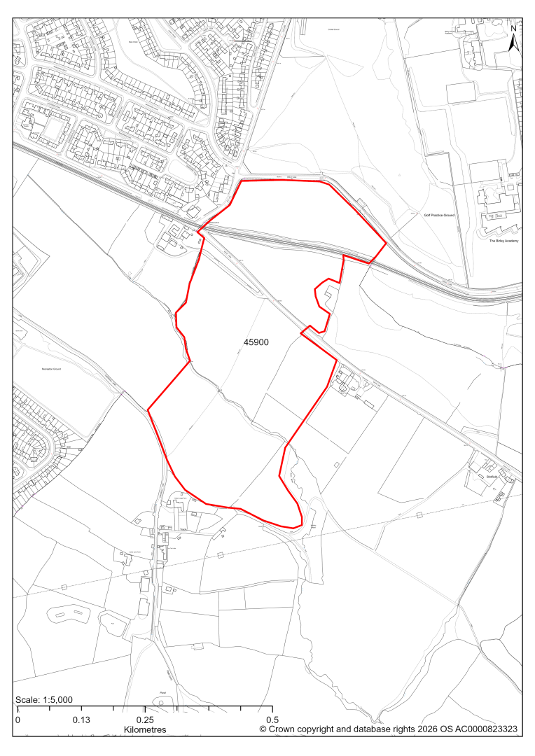
45900 – White Lane Farm, White Lane, Ridgeway, Sheffield
- This site may be able to support approximately 350 dwellings, based on prevailing neighbouring densities, and a 20% density uplift for towns and cities. Mitigation measures have not been applied to this site capacity yet and may result in an altered total.
- The site is located within the Green Belt and will be assessed through a new Green Belt Review to identify the extent to which the site meets Green Belt purposes a, b & d (related to checking unrestricted sprawl, preventing neighbouring towns merging and preserving the setting and special character of historic towns). The review will identify whether the site is Grey Belt and will inform decisions over whether, or not, Green Belt boundaries should be amended to account for development needs – as required by the National Planning Policy Framework (2024).
- For information, the 2016/17 Green Belt Review showed that this site (which covers the entirety of GB land parcel SHEFF/GB/013 and SHEFF/GB/015 and a large part of parcel SHEFF/GB/014) performed strongly against Green Belt purposes a & b and weaker against purpose d. Please note: the new Green Belt Review will follow the detailed methodology set out in recent National Planning Practice Guidance, which differs to the approach taken in the 2016/17 review, in terms of assessment criteria and what can be considered to be a town). For this reason, the land parcel results may differ.
- The site adjoins the currently draft allocated land in Sheffield City Council’s draft Local Plan (Land south of White Lane, Site Ref: SS19).
- White Lane and the tram tracks both run across the site area.
- Development on the site may have a major landscape impact, in particular in isolation, without the consideration of Sheffield’s draft allocation. Impact is lower for the land to the north of the tramway.
- Archaeological assessment classifies the site as having archaeological/historic environment issues, but might be suitable for allocation with appropriate site specific policy.
- The site is located within the Moss Valley Conservation Area.
- The land south of White Lane is possibly of ecological interest due to brook, hedgerows and trees. Any design would need to avoid or minimise impacts, which may be possible within the large site area.
- Approximately 1% of the site is covered by flood risk zones 2 and 3, along the along the line of trees south of White Lane. There is also some risk of surface water flooding on the site.
- A Public Right of Way crosses the site.
- Natural England’s provisional agricultural land classification of the area is grade 3.
- The site is located within coal authority development high risk area.
If this site were to be taken forward as an allocation, mitigation measures for the above constraints will need to be considered and any Local Plan policy text should include the requirement to address and mitigate the constraints listed above.
Edge of Chesterfield
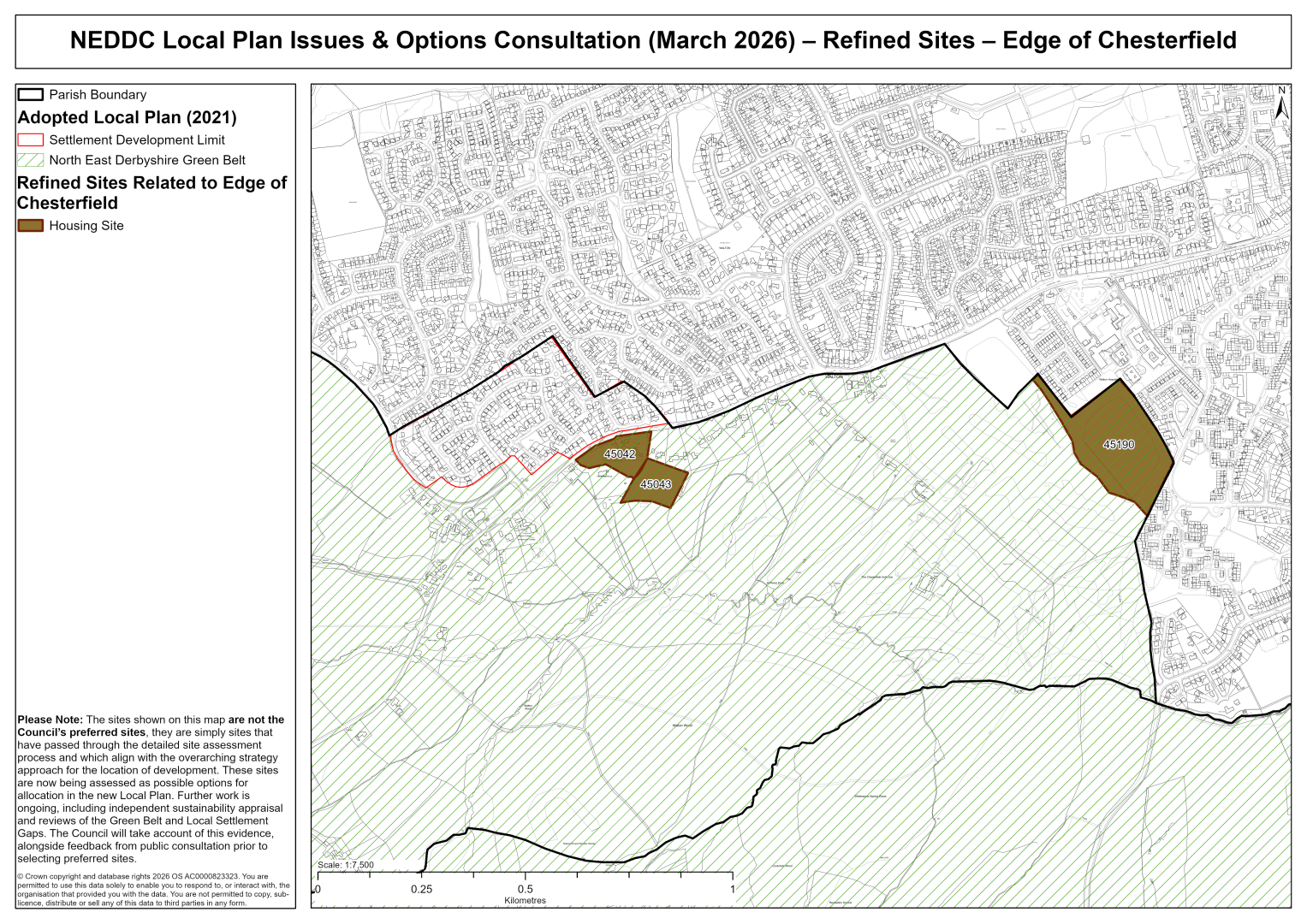
45042 – Redundant Nursery Land at Cherry Tree Farm, Walton
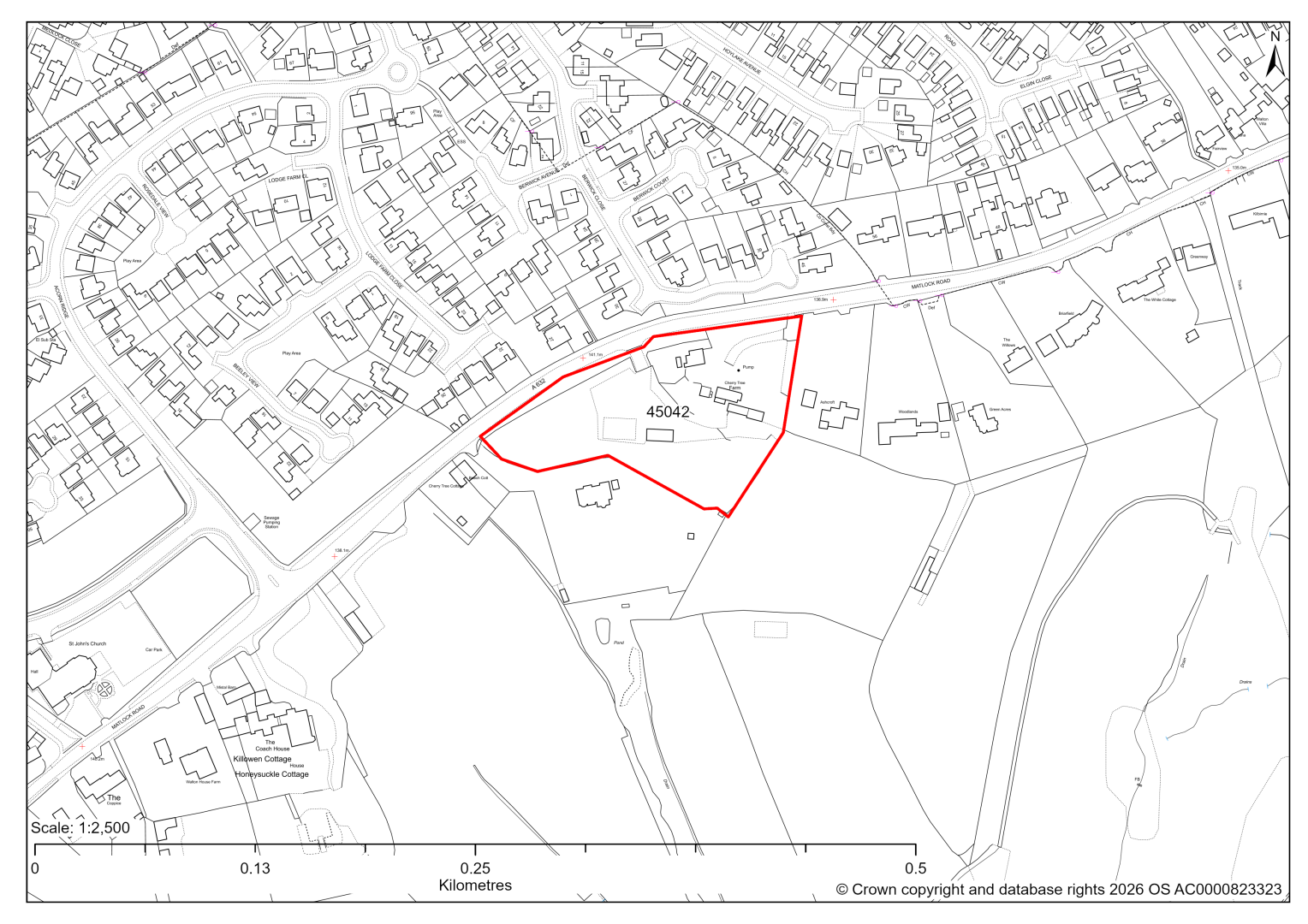
45042 – Redundant Nursery Land at Cherry Tree Farm, Walton
- This site may be able to support approximately 10 dwellings, based on prevailing neighbouring densities, and a 20% density uplift for towns and cities. Mitigation measures have not been applied to this site capacity yet and may result in an altered total.
- The site is located within the Green Belt and will be assessed through a new Green Belt Review to identify the extent to which the site meets Green Belt purposes a, b & d (related to checking unrestricted sprawl, preventing neighbouring towns merging and preserving the setting and special character of historic towns). The review will identify whether the site is Grey Belt and will inform decisions over whether, or not, Green Belt boundaries should be amended to account for development needs – as required by the National Planning Policy Framework (2024).
- For information, the 2016/17 Green Belt Review showed that this site (which covers the entirety of GB land parcel WAL/GB/14 and a small part of parcel WAL/GB/15) performed strongly against Green Belt purpose a, and moderately/weakly against purposes b & d. Please note: the new Green Belt Review will follow the detailed methodology set out in recent National Planning Practice Guidance, which differs to the approach taken in the 2016/17 review, in terms of assessment criteria and what can be considered to be a town). For this reason, the land parcel results may differ.
- Landscape assessment is yet to take place.
- The site includes Grade II Listed Building Cherry Tree Farmhouse, which will need to be excluded from any developable area. Furthermore, impact of new development upon the Listed Building will need to be considered.
- Ecological desktop assessment has found possible moderately diverse grassland and some hedgerows and trees of note, but the aerial images were inconclusive with regards to exact habitat type and site visits will determine ecology impact.
- Natural England’s provisional agricultural land classification of the area is grade 3.
- There is some risk of surface water flooding on the site.
If this site were to be taken forward as an allocation, mitigation measures for the above constraints will need to be considered and any Local Plan policy text should include the requirement to address and mitigate the constraints listed above.
45043 – Land A at Cherry Tree Farm, Walton
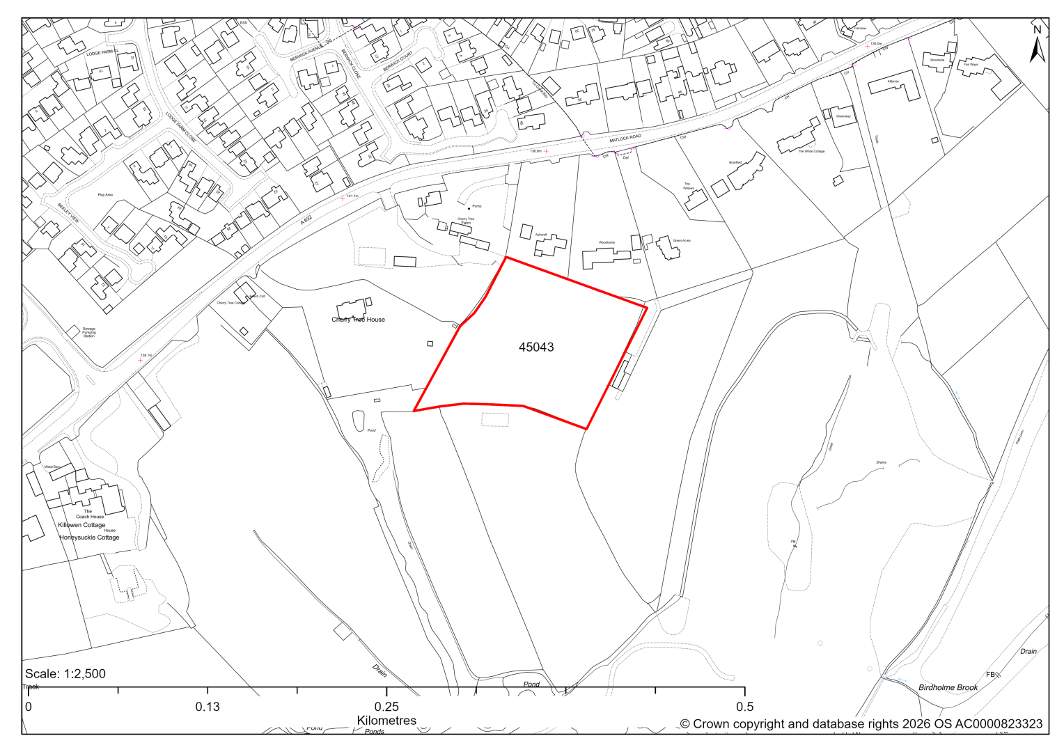
45043 – Land A at Cherry Tree Farm, Walton
- This site may be able to support approximately 10 dwellings, based on prevailing neighbouring densities, and a 20% density uplift for towns and cities. Mitigation measures have not been applied to this site capacity yet and may result in an altered total.
- The site is located within the Green Belt and will be assessed through a new Green Belt Review to identify the extent to which the site meets Green Belt purposes a, b & d (related to checking unrestricted sprawl, preventing neighbouring towns merging and preserving the setting and special character of historic towns). The review will identify whether the site is Grey Belt and will inform decisions over whether, or not, Green Belt boundaries should be amended to account for development needs – as required by the National Planning Policy Framework (2024).
- For information, the 2016/17 Green Belt Review showed that this site (which lies within GB land parcel: WAL/GB/013) performed performed strongly against Green Belt purposes a & b and weaker against purpose d. Please note: the new Green Belt Review will follow the detailed methodology set out in recent National Planning Practice Guidance, which differs to the approach taken in the 2016/17 review, in terms of assessment criteria and what can be considered to be a town). For this reason, the land parcel results may differ.
- Development on the site may have a moderate landscape impact.
- Ecological desktop assessment has found possible moderately diverse grassland, but the aerial images were inconclusive with regards to exact habitat type and site visits will determine ecology impact.
- Highway access will need to be achieved through neighbouring site 45042.
- There is some risk of surface water flooding on the site.
- Natural England’s provisional agricultural land classification of the area is grade 3.
If this site were to be taken forward as an allocation, mitigation measures for the above constraints will need to be considered and any Local Plan policy text should include the requirement to address and mitigate the constraints listed above.
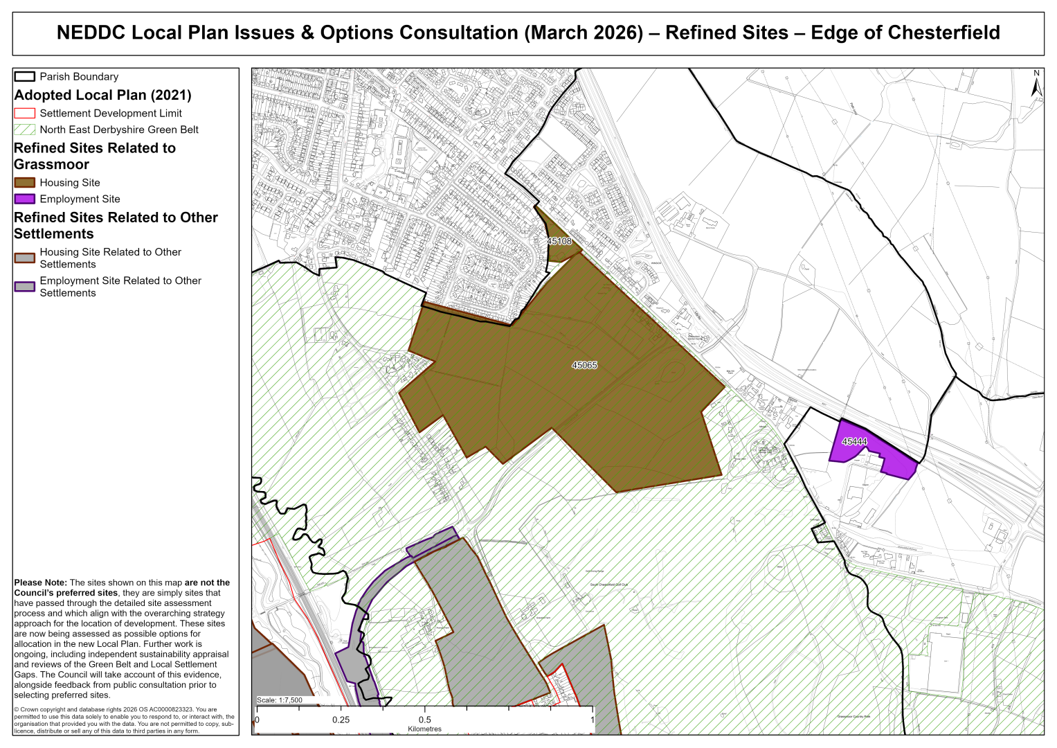
45065 – Land around Furnace Hillock Way, Hasland
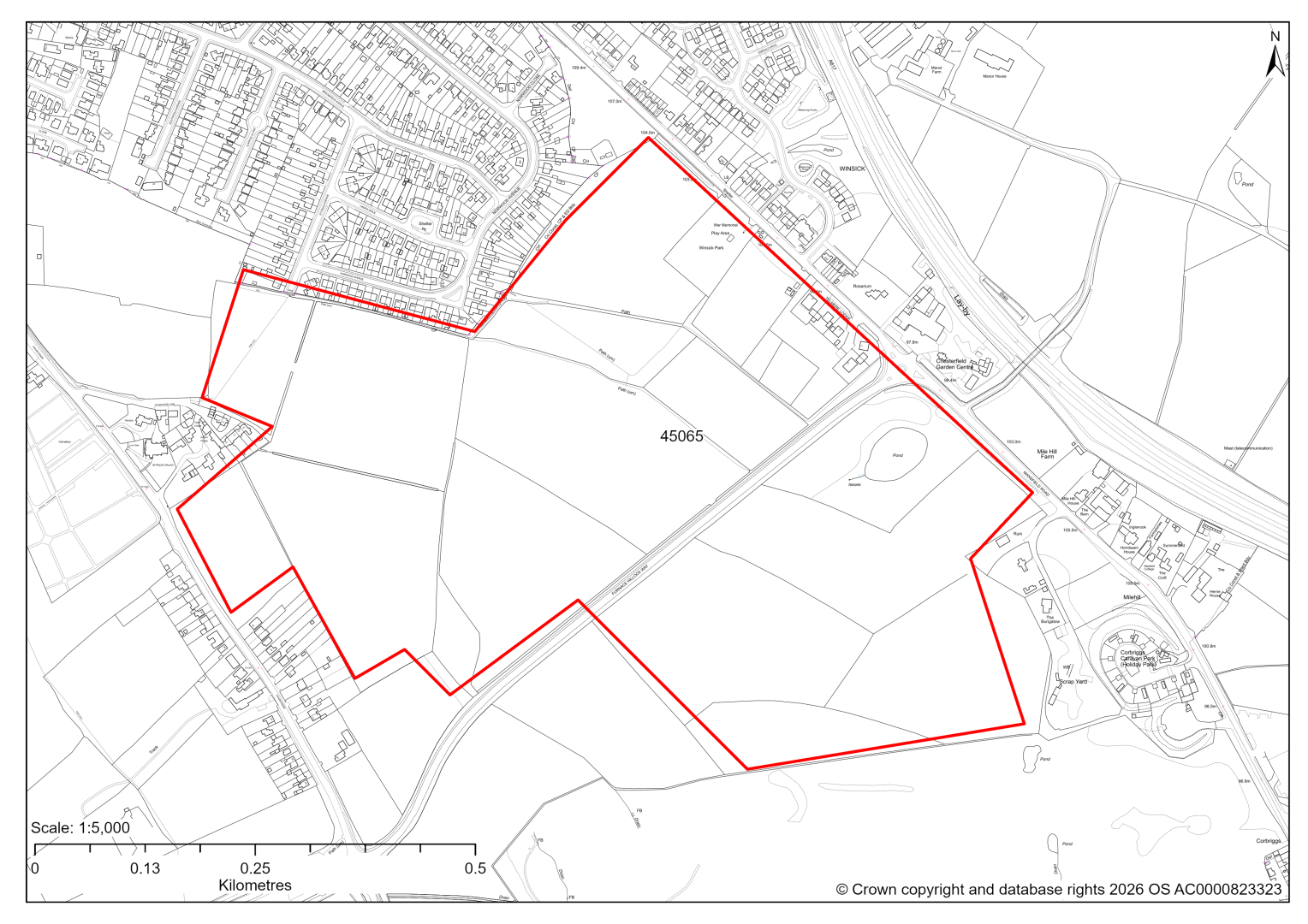
45065 – Land around Furnace Hillock Way, Hasland
- This site may be able to support approximately 800 dwellings, based on prevailing neighbouring densities, and a 20% density uplift for towns and cities. Mitigation measures have not been applied to this site capacity yet and may result in an altered total.
- The site is located within the Green Belt and will be assessed through a new Green Belt Review to identify the extent to which the site meets Green Belt purposes a, b & d (related to checking unrestricted sprawl, preventing neighbouring towns merging and preserving the setting and special character of historic towns). The review will identify whether the site is Grey Belt and will inform decisions over whether, or not, Green Belt boundaries should be amended to account for development needs – as required by the National Planning Policy Framework (2024).
- For information, the 2016/17 Green Belt Review showed that this site (which covers the entirety of GB land parcels CHEST/GB/006,CHEST/GB/007,CHEST/GB/008 and a smaller part of parcel CHEST/GB/009) performed strongly against Green Belt purposes a & b and weaker against purpose d. Please note: the new Green Belt Review will follow the detailed methodology set out in recent National Planning Practice Guidance, which differs to the approach taken in the 2016/17 review, in terms of assessment criteria and what can be considered to be a town). For this reason, the land parcel results may differ.
- Development on the site may have a moderate landscape impact. There are also several sites to the north of Grassmoor. Future preferred allocation sites will need to take into account cumulative landscape impacts and any risk of coalescence between Chesterfield and Grassmoor.
- Archaeological assessment classifies the site as having archaeological / historic environment issues, but might be suitable for allocation with appropriate site specific policy.
- The Urban Green Space within the site should be retained or replaced to equal value within the site.
- There is a TPO area on the eastern edge of the site, along Mansfield Road.
- Desktop ecology advice finds a medium impact level of development upon biodiversity. Retaining the woodland, hedgerows, scrub and pond would likely reduce the impact and a site visit will possibly be needed in the spring.
- Public Rights of Way cross the site, as well as existing and proposed cycle routes and greenways.
- There is some risk of surface water flooding on the site, mainly concentrated around a pond to the south of Furnace Hillock Way.
- The site is located within coal authority development high risk area.
If this site were to be taken forward as an allocation, mitigation measures for the above constraints will need to be considered and any Local Plan policy text should include the requirement to address and mitigate the constraints listed above.
45108 – Land adjacent to Mansfield Road, Hasland
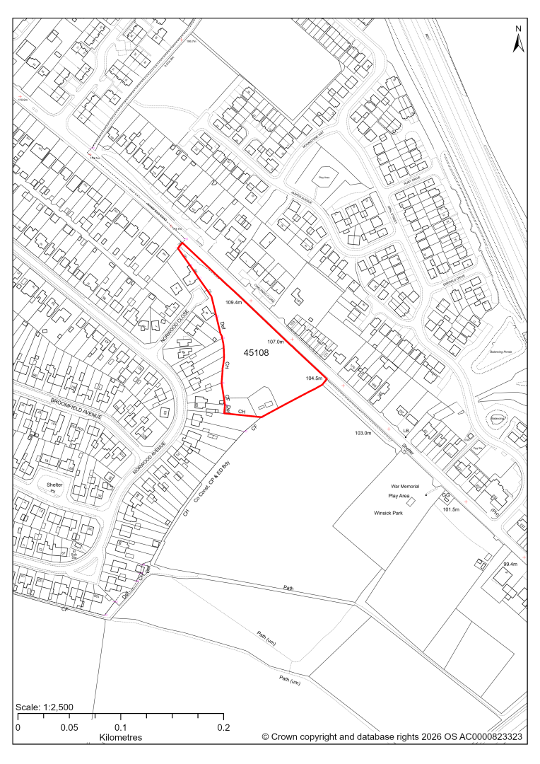
45108 – Land adjacent to Mansfield Road, Hasland
- This site may be able to support approximately 35 dwellings, based on prevailing neighbouring densities, and a 20% density uplift for towns and cities. Mitigation measures have not been applied to this site capacity yet and may result in an altered total.
- The site is located within the Green Belt and will be assessed through a new Green Belt Review to identify the extent to which the site meets Green Belt purposes a, b & d (related to checking unrestricted sprawl, preventing neighbouring towns merging and preserving the setting and special character of historic towns). The review will identify whether the site is Grey Belt and will inform decisions over whether, or not, Green Belt boundaries should be amended to account for development needs – as required by the National Planning Policy Framework (2024).
- For information, the 2016/17 Green Belt Review showed that this site (which lies within a smaller part of GB land parcel: CHEST/GB/009) performed moderately against Green Belt purposes a & b and weaker against purpose d. Please note: the new Green Belt Review will follow the detailed methodology set out in recent National Planning Practice Guidance, which differs to the approach taken in the 2016/17 review, in terms of assessment criteria and what can be considered to be a town). For this reason, the land parcel results may differ.
- Ecology advice finds a medium impact level of development upon biodiversity. The site supports a mosaic of habitats that are of value locally. It would be difficult to avoid direct impacts on these habitats as the site is small. The woodland and hedgerows are of greatest value and ideally would be retained. Mitigation and compensation likely to be possible to address impacts on the scrub and grassland.
- There are five TPO trees on the eastern and southern edges of the site.
- The site is located within coal authority development high risk area.
If this site were to be taken forward as an allocation, mitigation measures for the above constraints will need to be considered and any Local Plan policy text should include the requirement to address and mitigate the constraints listed above.
45190 – Land west of Harehill Road, Chesterfield
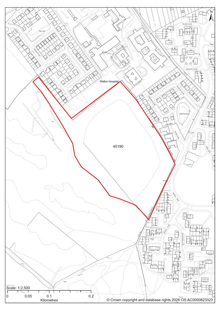
45190 – Land west of Harehill Road, Chesterfield
- This site may be able to support approximately 210 dwellings, based on prevailing neighbouring densities, and a 20% density uplift for towns and cities. Mitigation measures have not been applied to this site capacity yet and may result in an altered total.
- The site is located within the Green Belt and will be assessed through a new Green Belt Review to identify the extent to which the site meets Green Belt purposes a, b & d (related to checking unrestricted sprawl, preventing neighbouring towns merging and preserving the setting and special character of historic towns). The review will identify whether the site is Grey Belt and will inform decisions over whether, or not, Green Belt boundaries should be amended to account for development needs – as required by the National Planning Policy Framework (2024).
- For information, the 2016/17 Green Belt Review showed that this site (which covers the entirety of GB land parcel CHEST/GB/011) performed weakly against purposes a,b & d. Please note: the new Green Belt Review will follow the detailed methodology set out in recent National Planning Practice Guidance, which differs to the approach taken in the 2016/17 review, in terms of assessment criteria and what can be considered to be a town). For this reason, the land parcel results may differ.
- The outer edges of the site are identified as a Local Wildlife Site and/or priority habitat areas. However, ecological advice finds a low/moderate impact level of development upon biodiversity. Site visits find a field of modified grassland / other neutral grassland with other broad-leaved wood (plantation) bordering northern, eastern and southern aspects. Scattered native shrubs and early mature to mature trees occur along the remaining southern aspects.
- There is some risk of surface water flooding on the site.
- The site is located within coal authority development high risk area.
If this site were to be taken forward as an allocation, mitigation measures for the above constraints will need to be considered and any Local Plan policy text should include the requirement to address and mitigate the constraints listed above.
45444 – Land at Corrbriggs Industrial Estate
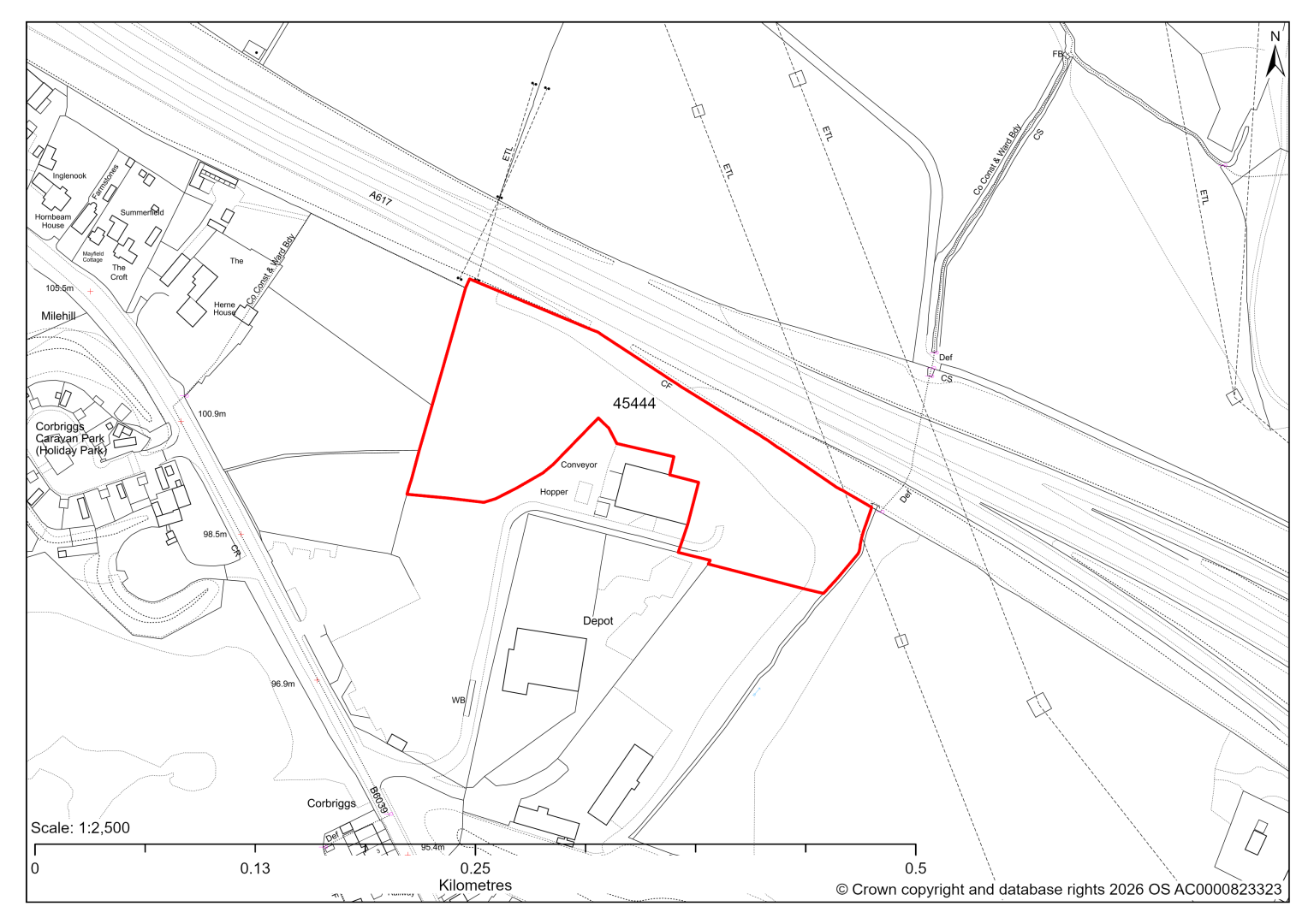
45444 – Land at Corbriggs Industrial Estate, Corbriggs (within Temple Normaton Parish)
- This site comprises an area of approximately 1.9 hectares of land within the Corbriggs Industrial Estate which is identified as a Principal Employment Area in the current 2014-2034 Local Plan. The site could support employment development.
- The site is adjacent to a Local Wildlife Site.
- The site supports scrub, trees and boundary hedgerows. Desktop ecology assessment finds a low / medium impact level of development upon biodiversity.
- The existing access from Mansfield Road is wide enough to accommodate two-way vehicle movements, but the route through the area to the site is less defined.
- Part of the site is located within a coal authority development high risk area.
If this site were taken forward as an employment allocation, mitigation measures for the above constraints will need to be considered and any Local Plan policy text should include the requirement to address and mitigate the constraints listed above.
Strategic Site – Duckmanton Moor (45227 & 45541)
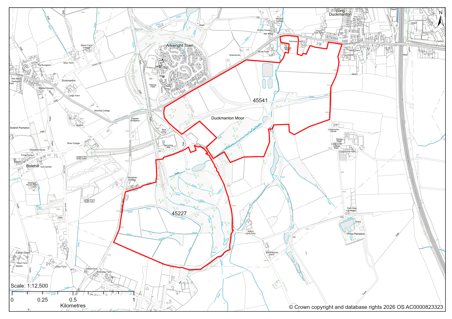
Strategic Site – Duckmanton Moor (45227 & 45541)
- In response to consultation feedback and dialogue with the site promoter we have combined these two sites into a single strategic site / new settlement in the east of the District.
- The site may be able to support approximately 2000 - 3000 dwellings, together with employment land and other supporting community facilities. Mitigation measures have not been applied to this site capacity yet and may result in an altered total.
- Initial landscape and heritage assessments point towards a possible impact on the settings of Sutton Scarsdale Hall (scheduled monument, grade I listed building) and its Conservation Area, and the collection of heritage assets at Bolsover Castle (scheduled monument, grade I listed buildings, grade I Registered Park & Garden, Conservation Area).
- Due to the size of the site, the ecology impact ranges from low to high. There are potential Local Wildlife Sites, but there is also scope for development on the ecologically low value fields.
- Highway access and impacts on the local highway network will need further consideration.
- The site was formerly part of the larger Arkwright opencast coal site, including the old Arkwright village, which was relocated due to methane gas issues.
- Approximately 2% of site 45541 is covered by flood risk zones 2 and 3. There is also some risk of surface water flooding.
- Proposed cycle routes and greenways cross the site.
- Part of the site is close to a landfill site and a recycling facility.
If this site were to be taken forward as an allocation, mitigation measures for the above constraints will need to be considered and any Local Plan policy text should include the requirement to address and mitigate the constraints listed above.
Strategic Site – Eckington South (45226)
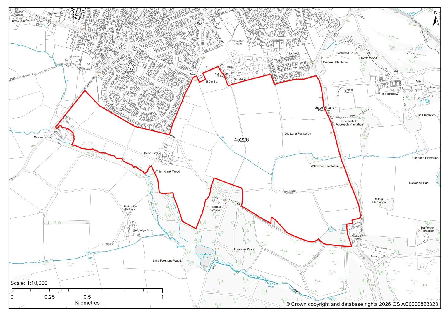
Strategic Site – Eckington South (45226)
- This site may be able to support approximately 1500-2500 dwellings. Mitigation measures have not been applied to this site capacity yet and may result in an altered total.
- The site is located within the Green Belt and will be assessed through a new Green Belt Review to identify the extent to which the site meets Green Belt purposes a, b & d (related to checking unrestricted sprawl, preventing neighbouring towns merging and preserving the setting and special character of historic towns). The review will identify whether the site is Grey Belt and will inform decisions over whether, or not, Green Belt boundaries should be amended to account for development needs – as required by the National Planning Policy Framework (2024).
- For information, the 2016/17 Green Belt Review assessed land parcels that adjoin the settlement of Eckington. Given the extent of this site, much of the land to the south was not assessed. (The northern part of the site wholly include GB land parcels ECK/GB/018, ECK/GB/020 and ECK/GB/021 and a large part of parcel ECK/GB/019) together these show that the land generally performed strongly against Green Belt purpose a (with the exception of GB parcel ECK/GB/21 which scored moderately), moderately against purpose b (except Eck/GB/19 which scored weakly) with all scoring weakly against purpose d. Please note: the new Green Belt Review will follow the detailed methodology set out in recent National Planning Practice Guidance, which differs to the approach taken in the 2016/17 review, in terms of assessment criteria and what can be considered to be a town. For this reason, the land parcel results may differ.
- Development on the site may have a strategic landscape impact. The northern and western parts of the site are likely to be the most accommodating of development as a sustainable extension to the southern edge of Eckington.
- Renishaw Grade II* Registered Park and Garden and other heritage assets are to the immediate east, including Grade I Listed Building Renishaw Hall. This parkland is also part of Eckington & Renishaw Conservation Area which extends further to the north east, Eckington High Street Conservation Area to the north, and Moss Valley Conservation Area further to north west. Their significance often derives not only from their internal features but also from their relationship with the surrounding landscape.
- Archaeological assessment classifies the site as having archaeological/ historic environment issues, but might be suitable for allocation with an appropriate site specific policy.
- Due to the size of the site, the ecology impact ranges from low to high. The site is adjacent to ancient woodland, Local Wildlife Site and priority habitat along the southern boundary. Development in these areas could result in adverse indirect impacts as well as reducing opportunities to implement measures for nature recovery. A buffer should be in place to protect the ancient woodland and LWS and the buffer area should be used as semi-natural green space (including habitat creation and enhancement) to strengthen habitat connectivity.
- Highway access and impacts on the local highway network will need further consideration.
- Approximately 7% of the site is covered by flood risk zones 2 and 3. There is also some risk of surface water flooding on the site.
- A Public Right of Way crosses the site.
- Natural England’s provisional agricultural land classification of the western area is grade 3.
- The site is located within a coal authority development high risk area.
If this site were to be taken forward as an allocation, mitigation measures for the above constraints will need to be considered and any Local Plan policy text should include the requirement to address and mitigate the constraints listed above.
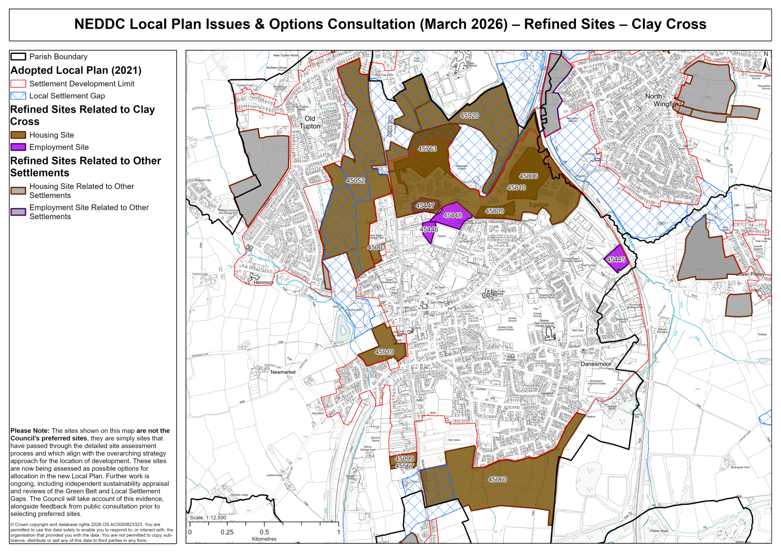
Clay Cross
45003 – 19b High Street Clay Cross
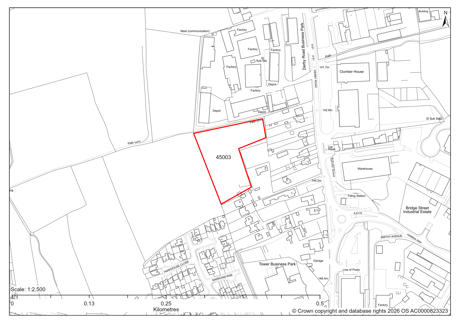
Site 45003 – 19b High Street Clay Cross
- This site may be able to support approximately 25 dwellings, based on prevailing neighbouring densities, and a 20% density uplift for towns and cities. Mitigation measures have not been applied to this site capacity yet and may result in an altered total.
- Archaeological assessment is yet to take place.
- Highway access can likely only be achieved through neighbouring site 45052.
- Ecology assessment is yet to take place.
- The site is located adjacent to an existing employment area.
- The site is located within coal authority development high risk area.
If this site were to be taken forward as an allocation, mitigation measures for the above constraints will need to be considered and any Local Plan policy text should include the requirement to address and mitigate the constraints listed above.
45052 – Land to the west of A61 Derby Road, Clay Cross
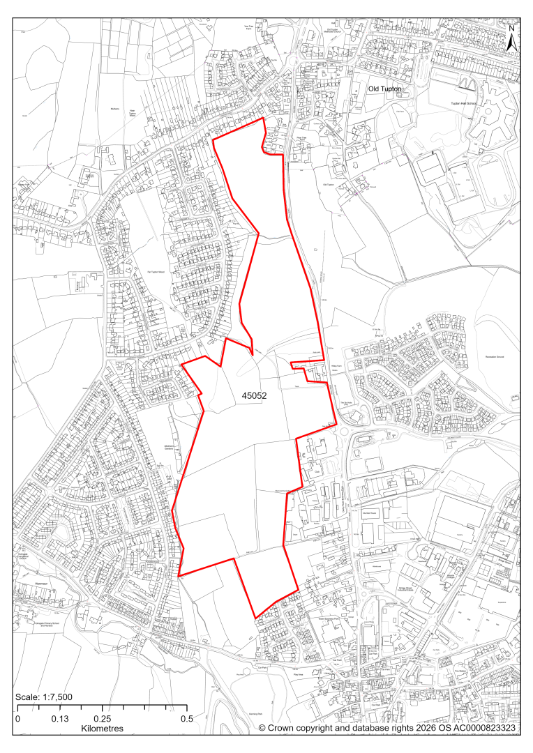
Site 45052 – Land to the west of A61 Derby Road, Clay Cross
- This site may be able to support approximately 560 dwellings, based on prevailing neighbouring densities, and a 20% density uplift for towns and cities. Mitigation measures have not been applied to this site capacity yet and may result in an altered total.
- A large part of the site is designated as a Local Settlement Gap in the current 2014-2034 Local Plan. An updated Local Settlement Gap Review will inform whether this designation is still appropriate for this site.
- Landscape assessment has found that development on the site would have a moderate landscape impact.
- Archaeological assessment classifies the site as having archaeological / historic environment issues, but might be suitable for allocation with appropriate site specific policy.
- Desktop ecological assessment has identified the main habitats as arable, modified grassland and possibly smaller areas of other neutral grassland. Site visits will determine ecology impact.
- There is a small TPO Area on site.
- Creating new highway access may require the removal of grass verges and hedgerow, and the gradient changes along the A61 will need to be considered.
- There is some risk of surface water flooding on the site.
- Public Rights of Way cross the site, as well as a proposed Key Cycle Network (KCN) route runs.
- The site is located adjacent to an existing employment area.
- The site is located within coal authority development high risk area.
If this site were to be taken forward as an allocation, mitigation measures for the above constraints will need to be considered and any Local Plan policy text should include the requirement to address and mitigate the constraints listed above.
45060 – Clay Cross South
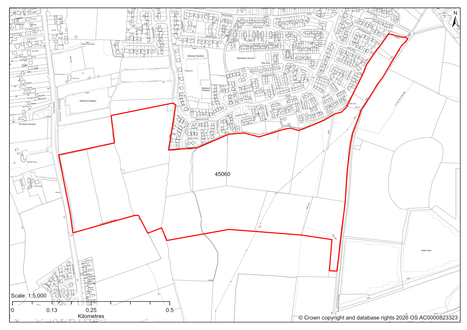
45060 – Clay Cross South
- This site may be able to support approximately 700 dwellings, based on prevailing neighbouring densities, and a 20% density uplift for towns and cities. Mitigation measures have not been applied to this site capacity yet and may result in an altered total.
- A part of the site (15%) is designated as a Local Settlement Gap in the current 2014-2034 Local Plan. An updated Local Settlement Gap Review will inform whether this designation is still appropriate for this site.
- Landscape assessment identifies strategic level impacts as it is a large site with potential effects on the landscape character and visual amenity of the surrounding area. The site is visually prominent particularly close to the A61 and it currently plays a role in the spatial separation of Clay Cross and Stretton, which is covered by the Local Settlement Gap. Impact may be reduced by excluding this land from the net developable area, only allowing highway access and maintaining the undeveloped character of the land.
- Archaeological assessment classifies the site as having archaeological / historic environment issues, but notes it might be suitable for allocation with appropriate site specific policy.
- The north eastern area of the site is designated as a Local Wildlife Site. Ecological assessment also finds that there is a valuable network of native hedgerows present. It recommends that impact of development can be reduced through the retention of the Local Wildlife Site, retention of native hedgerows and strengthening of corridors and connections through strategic habitat creation and enhancement as part of any development.
- Approximately 6% of the site is covered by flood risk zones 2 and 3 in the centre of the site. There is also some risk of surface water flooding on the site.
- Public Rights of Way cross the site.
- Natural England’s provisional agricultural land classification of the western area is grade 3.
- The site is located within coal authority development high risk area.
- If this site were to be taken forward as an allocation, mitigation measures for the above constraints will need to be considered and any Local Plan policy text should include the requirement to address and mitigate the constraints listed above.
45099 – Land north of Rykneld House, Stretton Road, Clay Cross
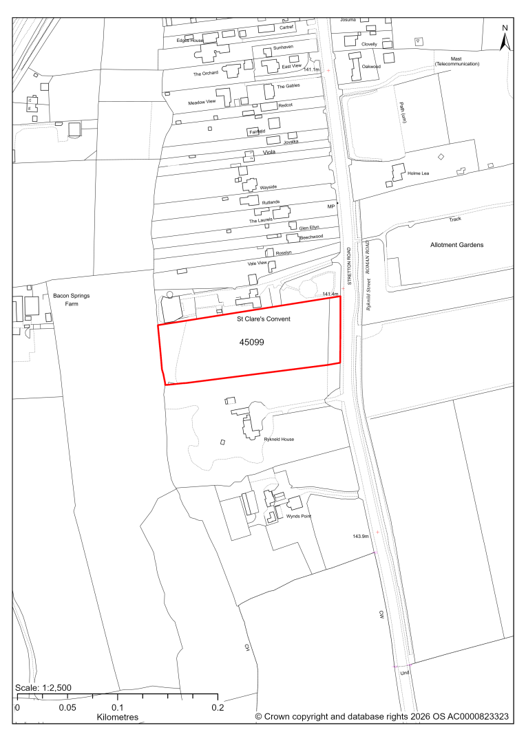
45099 – Land north of Rykneld House, Stretton Road, Clay Cross
- This site may be able to support approximately 20 dwellings, based on prevailing neighbouring densities, and a 20% density uplift for towns and cities. Mitigation measures have not been applied to this site capacity yet and may result in an altered total.
- To achieve satisfactory highway access, the tree line along plot frontage may need to be removed. Combining the site with site 45567 may provide access without loss of the tree line.
- The site is protected by a TPO Area.
- There is medium potential for roosting bats in the tree belt.
- There is some risk of surface water flooding on the site.
- The site is located within coal authority development high risk area.
If this site were to be taken forward as an allocation, mitigation measures for the above constraints will need to be considered and any Local Plan policy text should include the requirement to address and mitigate the constraints listed above.
45567 – Land north of Rykneld House, Stretton Road, Clay Cross
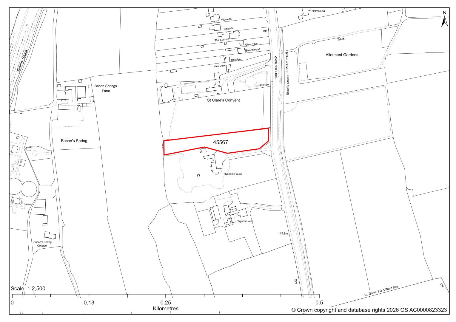
45567 – Land north of Rykneld House, Stretton Road, Clay Cross
- This site may be able to support approximately 8 dwellings, based on prevailing neighbouring densities, and a 20% density uplift for towns and cities. Mitigation measures have not been applied to this site capacity yet and may result in an altered total.
- It is considered that the site should be combined with site 45099.
- The site is protected by a TPO Area.
- There is some risk of surface water flooding on the site.
- The site is located within coal authority development high risk area.
If this site were to be taken forward as an allocation, mitigation measures for the above constraints will need to be considered and any Local Plan policy text should include the requirement to address and mitigate the constraints listed above.
45447, 45763,45806,45809,45810 – Former Biwaters Site
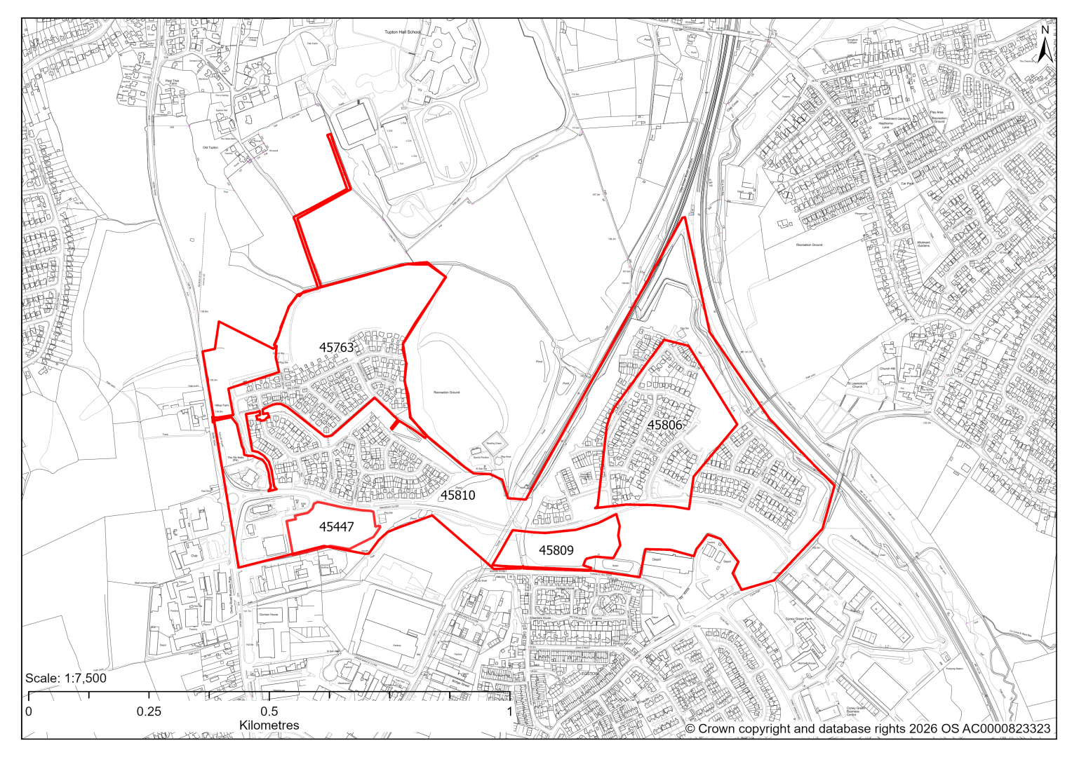
45447, 45763,45806,45809,45810 – Former Biwaters Site
The former Biwaters site has planning permission for housing and employment development, some of which has not been completed yet. This includes:
45810: outline planning permission for 825 dwellings and employment generating uses including E(g), B2 and B8 uses. 116 dwellings do not have detailed planning permission yet. We are intending to allocate any major sites with planning permission, if there is a remaining capacity of 10 or more dwellings that have not been completed yet.
45447: The site has detailed planning permission for employment development and is under construction. At our 2025 monitoring, the development on the site was well underway. 2026 monitoring is not yet available, but we are expecting the site to be fully completed and if so will include within our completion figures.
45763: The site has detailed planning permission for housing development and is under construction. At our 2025 monitoring, another 48 dwellings were yet to be completed. 2026 monitoring information is not available yet. We are intending to allocate any major sites with planning permission, if there is a remaining capacity of 10 or more dwellings that have not been completed yet.
45806: The site has detailed planning permission for housing development and is under construction. At our 2025 monitoring, another 42 dwellings were yet to be completed. 2026 monitoring information is not available yet. We are intending to allocate any major sites with planning permission, if there is a remaining capacity of 10 or more dwellings that have not been completed yet.
45809: The site has detailed planning permission for housing development. At our 2025 monitoring, the construction of 36 dwellings had yet to commence. 2026 monitoring information is not available yet. We are intending to allocate any major sites with planning permission, if there is a remaining capacity of 10 or more dwellings that have not been completed yet.
45919 – Kenning Park land, located to the west of High Street, Clay Cross
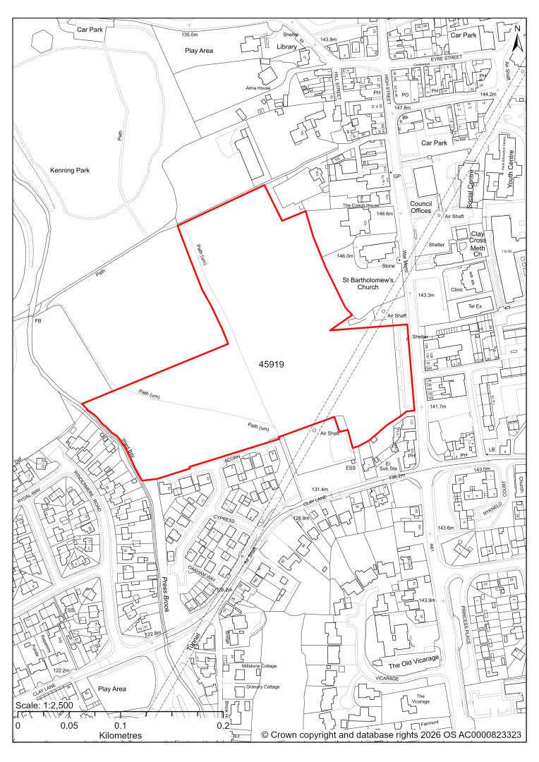
45919 – Kenning Park land, located to the west of High Street, Clay Cross
- This site may be able to support approximately 120 dwellings, based on prevailing neighbouring densities, and a 20% density uplift for towns and cities. Mitigation measures have not been applied to this site capacity yet and may result in an altered total.
- Landscape assessment has classified as moderate level impact.
- The site is in close proximity to Grade II Listed Building St Bartholomew’s Church.
- Desktop ecology advice finds a medium impact level of development upon biodiversity in the east of the site. A site visit will be needed in the spring.
- The frontage to the A61 includes an urban green space that will be excluded from any development area.
- Highway access may need to be confirmed further.
- Approximately 7% of the site is covered by flood risk zones 2 and 3 at the western area of the site. There is also some risk of surface water flooding on the site.
- Public Right of Way crosses the site.
- The railway tunnel runs underneath the site.
- The site is located within coal authority development high risk area.
If this site were to be taken forward as an allocation, mitigation measures for the above constraints will need to be considered and any Local Plan policy text should include the requirement to address and mitigate the constraints listed above.
45920 – Land north of Biwater, Clay Cross
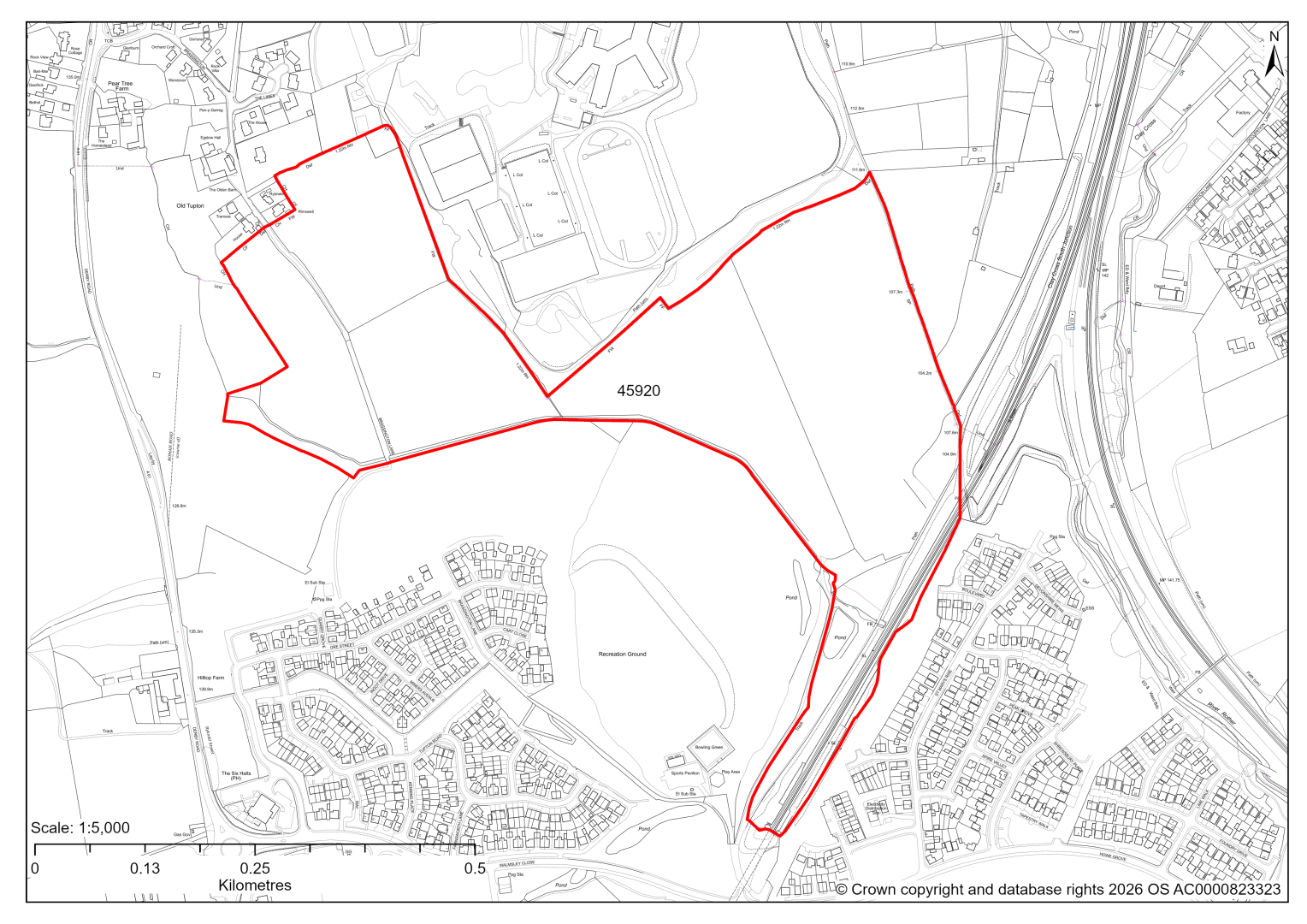
45920 – Land north of Biwater, Clay Cross
- This site may be able to support approximately 620 dwellings, based on prevailing neighbouring densities, and a 20% density uplift for towns and cities. Mitigation measures have not been applied to this site capacity yet and may result in an altered total.
- A larger site area has been submitted, which has only undergone initial assessment and can be viewed in the appendix to the Housing Land Availability Assessment.
- The site is designated as a Local Settlement Gap in the current 2014-2034 Local Plan. An updated Local Settlement Gap Review will inform whether this designation is still appropriate for this site.
- Landscape assessment has classified as having a moderate level impact, but recommends that any allocation should omit land to the west of Brassington Lane to reduce the overall visual impact of any development and reduce the perception of urban sprawl along the A61 corridor.
- Archaeological assessment classifies the site as having archaeological/ historic environment issues, but might be suitable for allocation with appropriate site specific policy.
- The north portal to the Clay Cross railway tunnel is Grade II listed.
- The south eastern area includes a priority habitat area. Desktop ecology advice finds a medium impact level of development upon biodiversity, in relation to the woodland on site. Due to the large site size, there may be opportunities to avoid and minimise impacts. A site visit will be needed in the spring.
- Highway access may need to be confirmed further. In its current form Brassington Lane is unsuitable for this scale of development, and options would need to be considered.
- There is some risk of surface water flooding on the site.
- Public Rights of Way, as well as proposed cycle routes and greenways cross the site.
- The site is located within coal authority development high risk area.
If this site were to be taken forward as an allocation, mitigation measures for the above constraints will need to be considered and any Local Plan policy text should include the requirement to address and mitigate the constraints listed above.
45445 – Plot H, Coney Green Business Park, Clay Cross
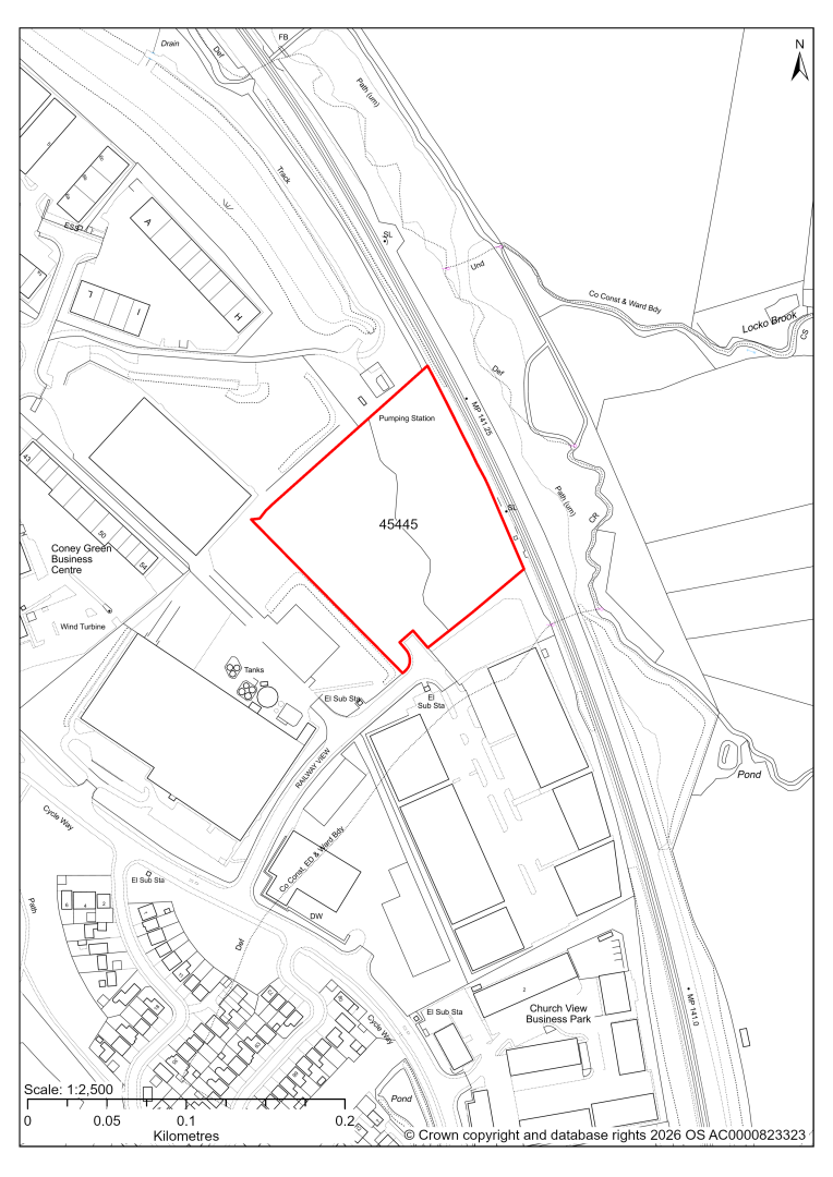
45445 – Plot H, Coney Green Business Park, Clay Cross
- This site comprises a plot of 1.67 hectares of land within the Coney Green Business Park which is identified as a Principal Employment Area in the current 2024-2034 Local Plan. The site could support employment development.
- The site consists of scrub, grassland and woodland bounded by hedgerows. Desktop ecology advice considers development of the site would have medium level impact upon biodiversity. Site visits will need to take place to further determine ecology impacts.
- The existing T-junction at the end of Railway View provides the opportunity to create access into the site.
- The River Rother lies 40 metres to the east of the site beyond the railway line. Less than 0.5% of the site in the northern corner falls within Flood Zones 2 and 3.
- Approximately 19% of the site is at risk of surface water flooding, predominately along the eastern boundary.
- The site is located within the coal authority development high risk area.
- If this site were to be taken forward as an allocation, mitigation measures for the above constraints will need to be considered and any Local Plan policy text should include the requirement to address and mitigate the constraints listed above.
45446 – Land off Upper Mantle Close, Bridge Street Industrial Estate, Clay Cross
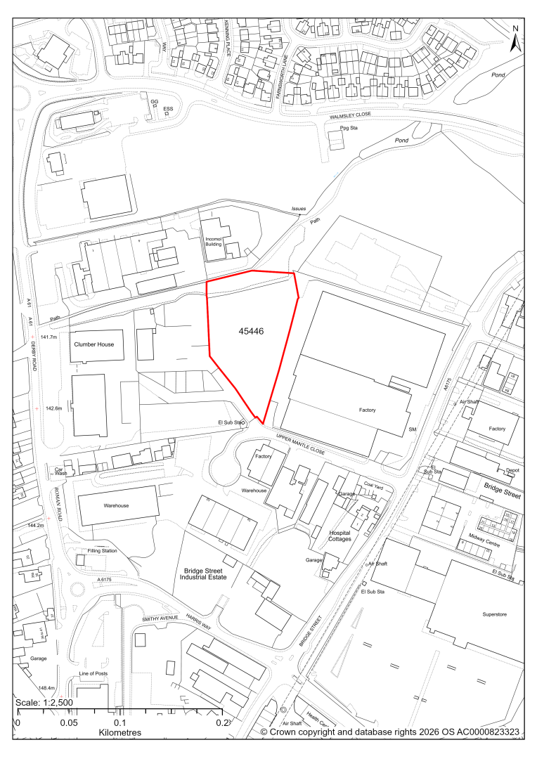
45446 – Land off Upper Mantle Close, Bridge Street Industrial Estate, Clay Cross
- This site comprises a 0.90 hectares plot of land within the Bridge Street Industrial Estate which is identified as a Principal Employment Area in the current 2024-2034 Local Plan. The site could support employment development.
- The main habitats on the site are woodland, scrub and grassland. Desktop ecology advice finds a medium impact level of development upon biodiversity, in relation to the loss of woodland. Site visits will need to take place to further determine ecology impacts.
- Creating a suitable access arrangement may be achievable between the adjacent employment uses but would require the removal of the existing pavement.
- Approximately 11% of the site is at risk of surface water flooding predominately along its eastern boundary.
- A planning application for industrial development on the site is currently pending determination by the council (planning application ref: 25/00435/FL).
- If this site were to be taken forward as an employment allocation, mitigation measures for the above constraints will need to be considered and any Local Plan policy text should include the requirement to address and mitigate the constraints listed above.
45448 – Land off Bridge Street, Clay Cross
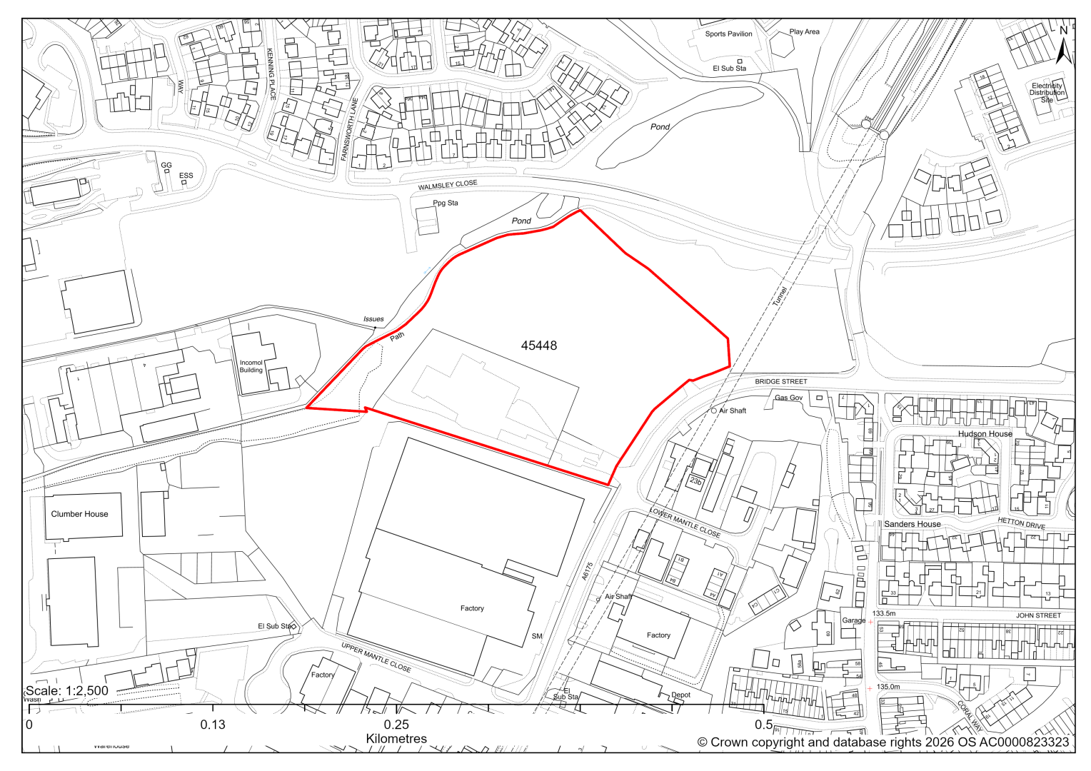
45448 – Land off Bridge Street, Clay Cross
- This site comprises approximately 2.8 hectares of land located at the northern end of the Bridge Street Industrial Estate which is identified as a Principal Employment Area in the current 2024-2034 Local Plan. The site could support employment development.
- The main habitats on the site are woodland, hedgerows, scrub and grassland. Desktop ecology advice finds a medium / high impact level of development upon biodiversity, in relation to the loss of woodland. Site visits will need to take place to further determine ecology impacts.
- There is an existing access into the site, but visibility is restricted by a sharp bend in the road to the north and there is a junction opposite.
- Approximately 6% of the site, predominately along its northeastern boundary, is at risk of surface water flooding.
- The site forms part of a former landfill site, as such there may be contamination issues on the site which would need to be addressed at the planning application stage.
- If this site were to be taken forward as an employment allocation, mitigation measures for the above constraints will need to be considered and any Local Plan policy text should include the requirement to address and mitigate the constraints listed above.
Dronfield
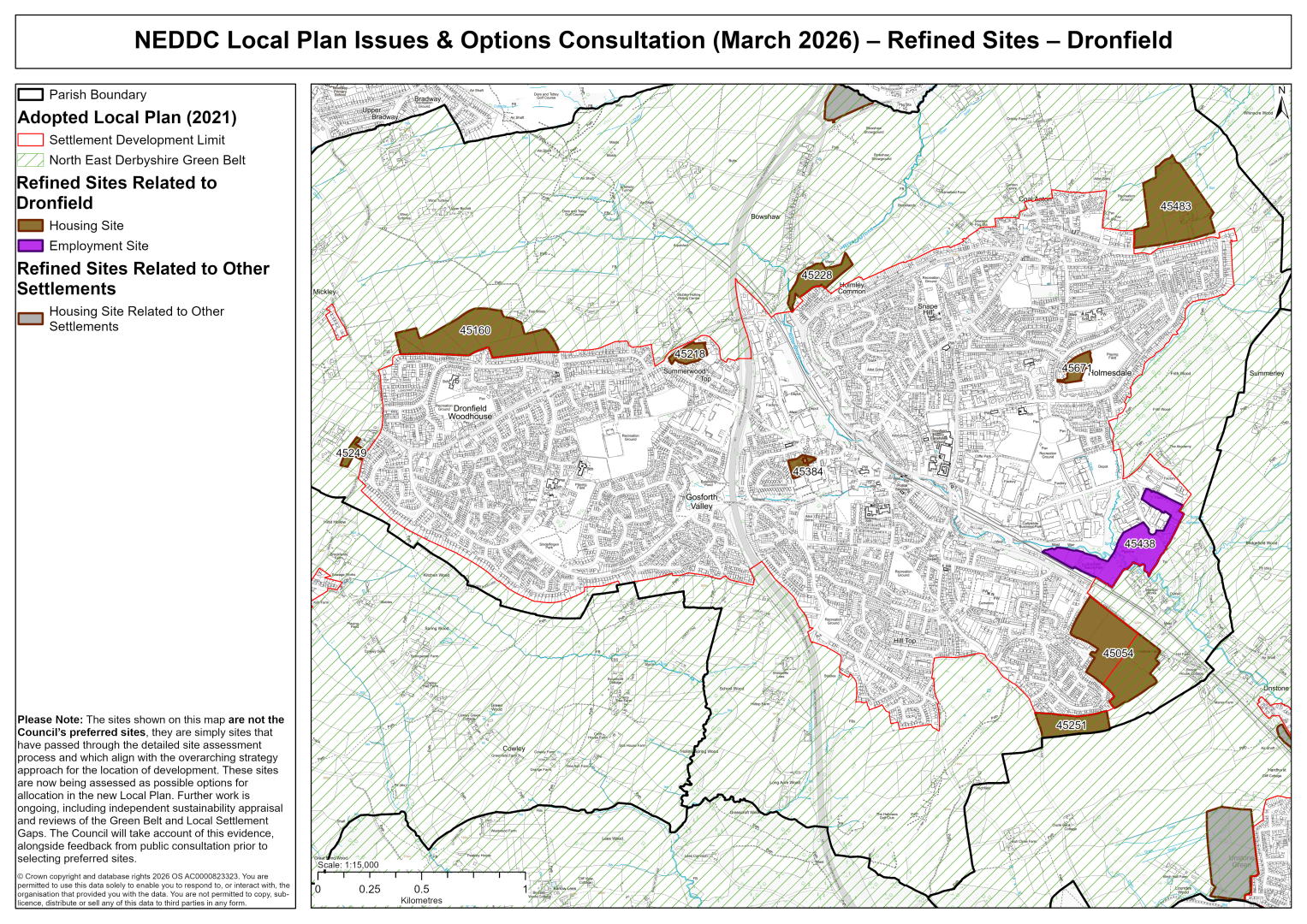
45054 – Land North of Burns Drive and East of Southfield Mount, Dronfield
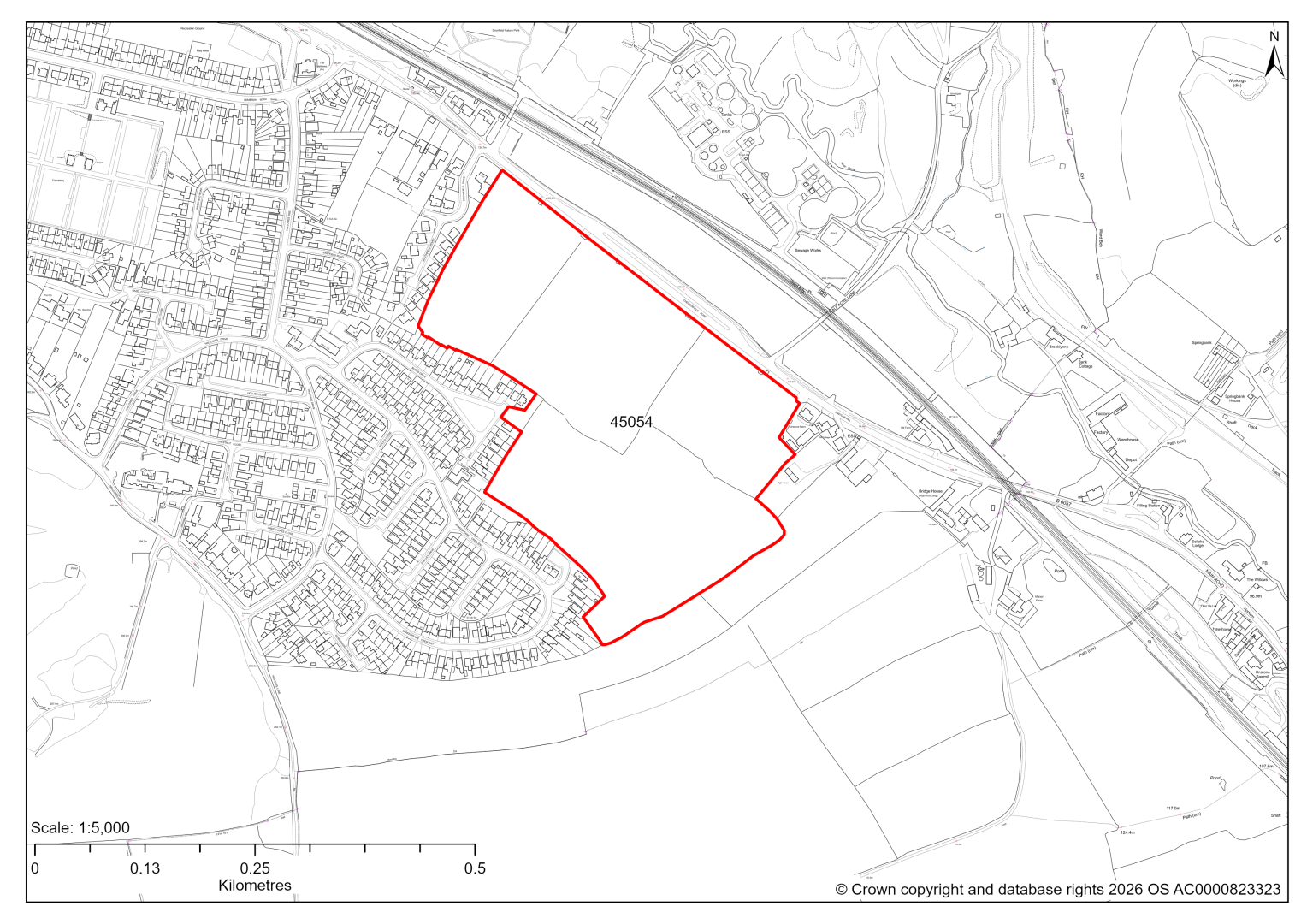
45054 – Land North of Burns Drive and East of Southfield Mount, Dronfield
- This site may be able to support approximately 240 dwellings, based on prevailing neighbouring densities, and a 20% density uplift for towns and cities. Mitigation measures have not been applied to this site capacity yet and may result in an altered total.
- Approximately 55% of the site is a housing allocation in the current 2014-2034 Local Plan. The remaining 45% is located within the Green Belt.
- The site is located within the Green Belt and will be assessed through a new Green Belt Review to identify the extent to which the site meets Green Belt purposes a, b & d (related to checking unrestricted sprawl, preventing neighbouring towns merging and preserving the setting and special character of historic towns). The review will identify whether the site is Grey Belt and will inform decisions over whether, or not, Green Belt boundaries should be amended to account for development needs – as required by the National Planning Policy Framework (2024).
- For information, the 2016/17 Green Belt Review showed that this site (which covers the entirety of GB land parcel DRO/GB/042 and a smaller part of parcel DRO/GB/043) performed moderately against purposes a & b and weakly against purpose d. Please note: the new Green Belt Review will follow the detailed methodology set out in recent National Planning Practice Guidance, which differs to the approach taken in the 2016/17 review, in terms of assessment criteria and what can be considered to be a town). For this reason, the land parcel results may differ.
- Development on the site may have a moderate landscape impact.
- Archaeological assessment classifies the site as having archaeological /historic environment issues, but might be suitable for allocation with appropriate site specific policy.
- The ecology assessments find a moderate impact and recommend that development retains hedgerow and trees and avoids or minimises impacts on protected species. There are several TPO trees on the outer edges of the site.
- A small part of the site is within 250 metres of a wastewater treatment works.
- A Public Rights of Way crosses the site.
- Topography may cause constraints to development.
If this site were to be taken forward as an allocation, mitigation measures for the above constraints will need to be considered and any Local Plan policy text should include the requirement to address and mitigate the constraints listed above.
45160 – Land north of Dronfield Woodhouse
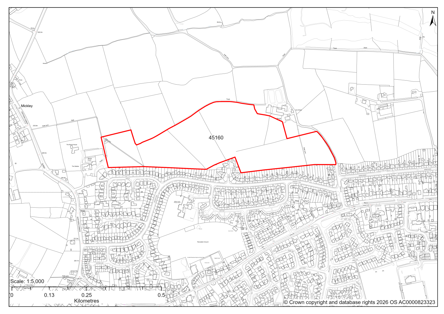
45160 – Land north of Dronfield Woodhouse
- This site may be able to support approximately 190 dwellings, based on prevailing neighbouring densities, and a 20% density uplift for towns and cities. Mitigation measures have not been applied to this site capacity yet and may result in an altered total.
- The site is located within the Green Belt and will be assessed through a new Green Belt Review to identify the extent to which the site meets Green Belt purposes a, b & d (related to checking unrestricted sprawl, preventing neighbouring towns merging and preserving the setting and special character of historic towns). The review will identify whether the site is Grey Belt and will inform decisions over whether, or not, Green Belt boundaries should be amended to account for development needs – as required by the National Planning Policy Framework (2024).
- For information, the 2016/17 Green Belt Review showed that this site (which covers the entirety of GB land parcel DRO/GB/078) performed strongly against purposes a & b and weakly against purpose d. Please note: the new Green Belt Review will follow the detailed methodology set out in recent National Planning Practice Guidance, which differs to the approach taken in the 2016/17 review, in terms of assessment criteria and what can be considered to be a town). For this reason, the land parcel results may differ.
- Desktop ecology advice finds a low/medium impact level of development upon biodiversity. There is one field that has previously been identified as supporting grassland of interest and this needs to be assessed further. A site visit will be needed in the spring.
- Highway access from Barnes Lane may need to be confirmed further.
- Archaeological assessment classifies the site as having archaeological/ historic environment issues, but might be suitable for allocation with appropriate site specific policy. This is due to possible early settlement focus at Barnes Farm.
- There is some risk of surface water flooding on the site.
- Public Rights of Way cross the site.
- Natural England’s provisional agricultural land classification of the area is grade 3.
- The site is located within coal authority development high risk area.
If this site were to be taken forward as an allocation, mitigation measures for the above constraints will need to be considered and any Local Plan policy text should include the requirement to address and mitigate the constraints listed above.
45218 – Land at Stubley Lane, Stubley Hollow, Dronfield
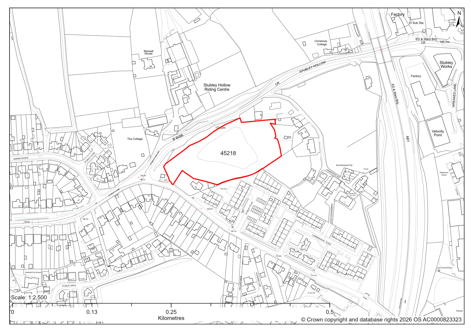
45218 – Land at Stubley Lane, Stubley Hollow, Dronfield
- This site may be able to support approximately 40 dwellings, based on prevailing neighbouring densities, and a 20% density uplift for towns and cities. Mitigation measures have not been applied to this site capacity yet and may result in an altered total.
- The site is located within the Green Belt and will be assessed through a new Green Belt Review to identify the extent to which the site meets Green Belt purposes a, b & d (related to checking unrestricted sprawl, preventing neighbouring towns merging and preserving the setting and special character of historic towns). The review will identify whether the site is Grey Belt and will inform decisions over whether, or not, Green Belt boundaries should be amended to account for development needs – as required by the National Planning Policy Framework (2024).
- For information, the 2016/17 Green Belt Review showed that this site (which lies within GB land parcel: DRO/GB/081) performed weaker against Green Belt purposes a, b & d. Please note: the new Green Belt Review will follow the detailed methodology set out in recent National Planning Practice Guidance, which differs to the approach taken in the 2016/17 review, in terms of assessment criteria and what can be considered to be a town). For this reason, the land parcel results may differ.
- The site is a housing allocation in the current 2014-2034 Local Plan.
- There is one group of TPO trees on the site and six individual TPO trees, along the western edge of the site.
- Natural England’s provisional agricultural land classification of the area is grade 3.
- The site is located within coal authority development high risk area.
If this site were to be taken forward as an allocation, mitigation measures for the above constraints will need to be considered and any Local Plan policy text should include the requirement to address and mitigate the constraints listed above.
45228 – Land at Holmley Common, Dronfield
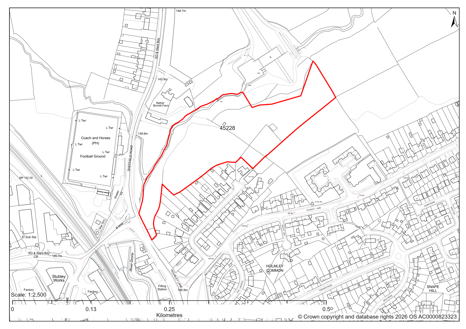
45228 – Land at Holmley Common, Dronfield
- This site may be able to support approximately 60 dwellings, based on prevailing neighbouring densities, and a 20% density uplift for towns and cities. Mitigation measures have not been applied to this site capacity yet and may result in an altered total.
- The site is located within the Green Belt and will be assessed through a new Green Belt Review to identify the extent to which the site meets Green Belt purposes a, b & d (related to checking unrestricted sprawl, preventing neighbouring towns merging and preserving the setting and special character of historic towns). The review will identify whether the site is Grey Belt and will inform decisions over whether, or not, Green Belt boundaries should be amended to account for development needs – as required by the National Planning Policy Framework (2024).
- For information, the 2016/17 Green Belt Review showed that this site (which lies within GB land parcel : DRO/GB/008) performed strongly against Green Belt purposes a & b and weakly against purpose d. Please note: the new Green Belt Review will follow the detailed methodology set out in recent National Planning Practice Guidance, which differs to the approach taken in the 2016/17 review, in terms of assessment criteria and what can be considered to be a town). For this reason, the land parcel results may differ.
- The site is in close proximity to Grade II Listed Buildings at Nether Birchitt.
- Archaeological assessment classifies the site as having archaeological/historic environment issues, but might be suitable for allocation with appropriate site specific policy.
- Desktop ecology advice finds a medium impact level of development upon biodiversity and recommends that development establishes a buffer to the river and retain woodland habitats to minimise impacts. A site visit will be needed in the spring.
- Highway access would need to be confirmed further.
- The northern part of the site (14%) is covered by flood risk zones 2 and 3 around the watercourse, and should be excluded from development.
- Natural England’s provisional agricultural land classification of the area is grade 3.
- The site is located within coal authority development high risk area.
If this site were to be taken forward as an allocation, mitigation measures for the above constraints will need to be considered and any Local Plan policy text should include the requirement to address and mitigate the constraints listed above.
45249 – Land adjacent to Meadow Grange Care Home, Holmesfield Road, Dronfield Woodhouse
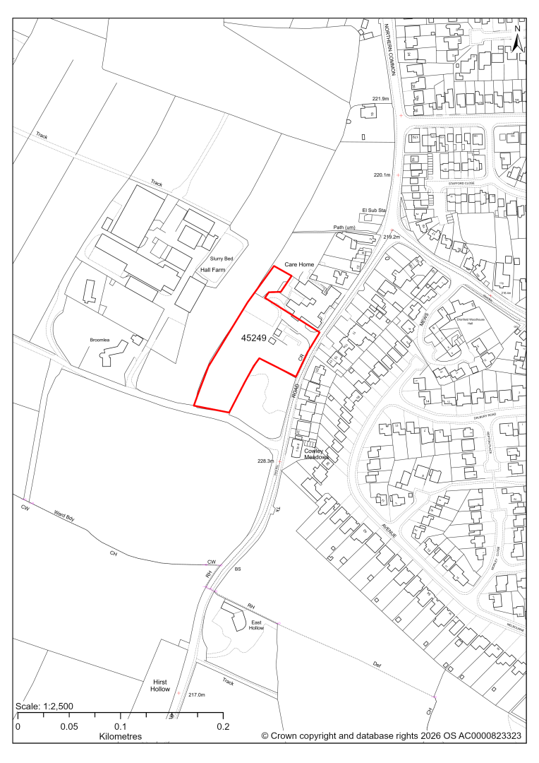
45249 – Land adjacent to Meadow Grange Care Home, Holmesfield Road, Dronfield Woodhouse
- This site has been put forward as a site for independent housing for older people linking to the existing care home. The site may be able to support approximately 15 dwellings, based on prevailing neighbouring densities, and a 20% density uplift for towns and cities. Mitigation measures have not been applied to this site capacity yet and may result in an altered total.
- The site is located within the Green Belt and will be assessed through a new Green Belt Review to identify the extent to which the site meets Green Belt purposes a, b & d (related to checking unrestricted sprawl, preventing neighbouring towns merging and preserving the setting and special character of historic towns). The review will identify whether the site is Grey Belt and will inform decisions over whether, or not, Green Belt boundaries should be amended to account for development needs – as required by the National Planning Policy Framework (2024).
- For information, the 2016/17 Green Belt Review showed that this site (which covers a large part of GB land parcel DRO/GB/067 and a small part of parcel DRO/GB/068) performed strongly against Green Belt purpose a, moderately against purpose b and weaker against purpose d. Please note: the new Green Belt Review will follow the detailed methodology set out in recent National Planning Practice Guidance, which differs to the approach taken in the 2016/17 review, in terms of assessment criteria and what can be considered to be a town). For this reason, the land parcel results may differ.
- Development on the site may have a moderate landscape impact.
- The Care Home is considered a non-designated heritage asset and the northern part of the site is located within the Dronfield Woodhouse Conservation Area.
- Desktop ecology advice finds a low/medium impact level of development upon biodiversity. The site supports hedgerows, shrubs and mature trees that could be of value. A site visit will be needed in the spring.
- Natural England’s provisional agricultural land classification of the area is grade 3.
If this site were to be taken forward as an allocation, mitigation measures for the above constraints will need to be considered and any Local Plan policy text should include the requirement to address and mitigate the constraints listed above.
45251 – Land off Highgate Lane, Dronfield
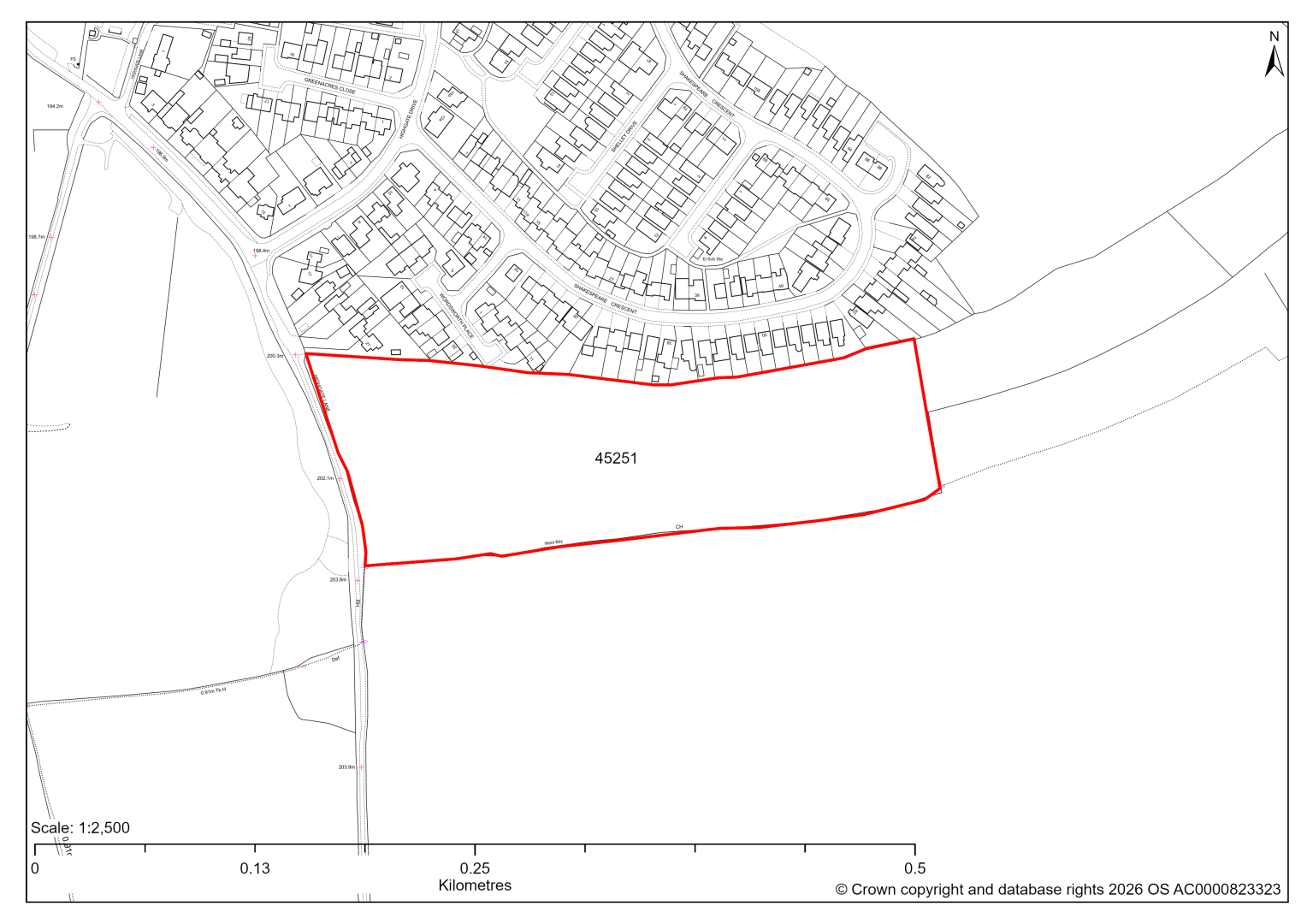
45251 – Land off Highgate Lane, Dronfield
- This site may be able to support approximately 100 dwellings, based on prevailing neighbouring densities, and a 20% density uplift for towns and cities. Mitigation measures have not been applied to this site capacity yet and may result in an altered total.
- The site is located within the Green Belt and will be assessed through a new Green Belt Review to identify the extent to which the site meets Green Belt purposes a, b & d (related to checking unrestricted sprawl, preventing neighbouring towns merging and preserving the setting and special character of historic towns). The review will identify whether the site is Grey Belt and will inform decisions over whether, or not, Green Belt boundaries should be amended to account for development needs – as required by the National Planning Policy Framework (2024).
- For information, the 2016/17 Green Belt Review showed that this site (which lies within a smaller part of GB land parcel: DRO/GB/044) performed strongly against Green Belt purposes a & b and weaker against purpose d. Please note: the new Green Belt Review will follow the detailed methodology set out in recent National Planning Practice Guidance, which differs to the approach taken in the 2016/17 review, in terms of assessment criteria and what can be considered to be a town). For this reason, the land parcel results may differ.
- Development on the site may have a moderate landscape impact.
- Archaeological assessment classifies the site as having archaeological/historic environment issues, but might be suitable for allocation with appropriate site specific policy.
- Satisfactory highway access will need to be confirmed further, as Highgate Lane is a narrow, single-track road, which would require widening to allow two vehicles to pass comfortably.
- The site is located within coal authority development high risk area.
If this site were to be taken forward as an allocation, mitigation measures for the above constraints will need to be considered and any Local Plan policy text should include the requirement to address and mitigate the constraints listed above.
45384 – Land at Manor Bungalows, Dronfield
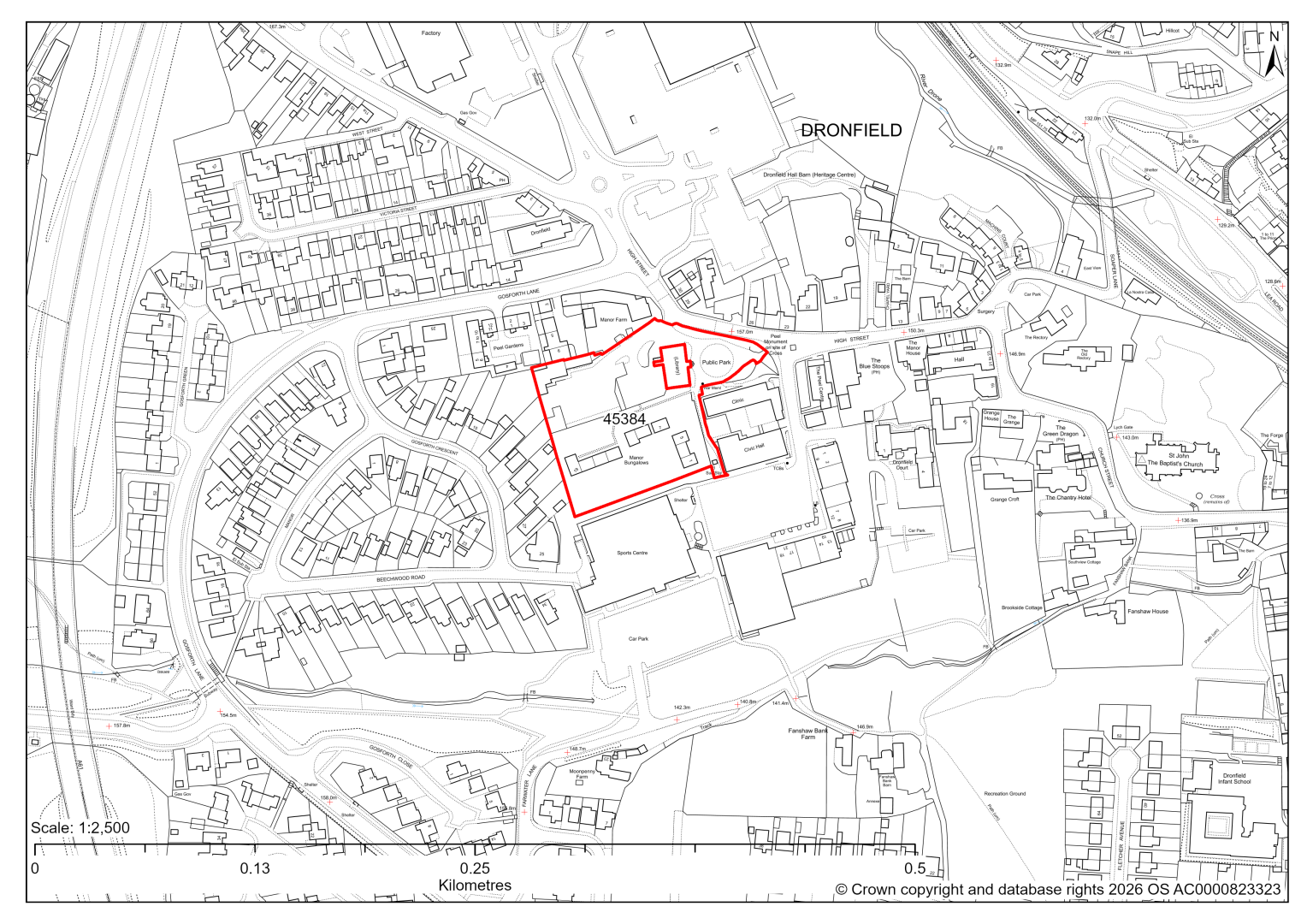
45384 – Land at Manor Bungalows, Dronfield
- This site may be able to support approximately 30 dwellings, based on prevailing neighbouring densities, and a 20% density uplift for main towns. Further uplift may be appropriate due to the central location within Dronfield. However, mitigation measures have not been applied to this site capacity yet and may result in an altered total.
- The site is located within a Conservation Area and includes / is within close proximity to several Listed Buildings and non-designated heritage assets.
- There are five individual TPO trees on the site, four on the north eastern edge of the site along High Street and one in the centre of the southern half of the site.
If this site were to be taken forward as an allocation, mitigation measures for the above constraints will need to be considered and any Local Plan policy text should include the requirement to address and mitigate the constraints listed above.
45483 – Land off Eckington Road, Coal Aston, Dronfield
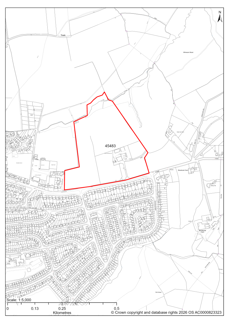
45483 – Land off Eckington Road, Coal Aston, Dronfield
- This site may be able to support approximately 160 dwellings, based on prevailing neighbouring densities, and a 20% density uplift for towns and cities. Mitigation measures have not been applied to this site capacity yet and may result in an altered total.
- The site is located within the Green Belt and will be assessed through a new Green Belt Review to identify the extent to which the site meets Green Belt purposes a, b & d (related to checking unrestricted sprawl, preventing neighbouring towns merging and preserving the setting and special character of historic towns). The review will identify whether the site is Grey Belt and will inform decisions over whether, or not, Green Belt boundaries should be amended to account for development needs – as required by the National Planning Policy Framework (2024).
- For information, the 2016/17 Green Belt Review showed that this site (which covers a large part of GB land parcel DRO/GB/025 and a small part of parcel DRO/GB/023) performed moderately against Green Belt purposes a & d and weaker against purpose b. Please note: the new Green Belt Review will follow the detailed methodology set out in recent National Planning Practice Guidance, which differs to the approach taken in the 2016/17 review, in terms of assessment criteria and what can be considered to be a town). For this reason, the land parcel results may differ.
- Development on the site may have a moderate landscape impact.
- The site is located within the Moss Valley Conservation Area.
- Ecology assessment finds that the northern part of the site includes Lowland Mixed Deciduous Woodland that forms a narrow corridor of woodland along a stream that connects to the Moss Valley SSSI. The fields to the south are characterised by generally species poor modified grasslands which usually are of lower nature conservation value. Whilst it may be possible to avoid or minimise some of the risks and potential impacts to habitats within the site and close to the site, development in this location may place additional pressures on the SSSI. Development would need to occupy a smaller footprint and provide mitigation and compensation to ensure negative impacts were fully addressed.
- There is some risk of surface water flooding on the site.
- The site is located within coal authority development high risk area.
If this site were to be taken forward as an allocation, mitigation measures for the above constraints will need to be considered and any Local Plan policy text should include the requirement to address and mitigate the constraints listed above.
45671 – Gladys Buxton Adult Education Centre, Oakhill Road, Dronfield
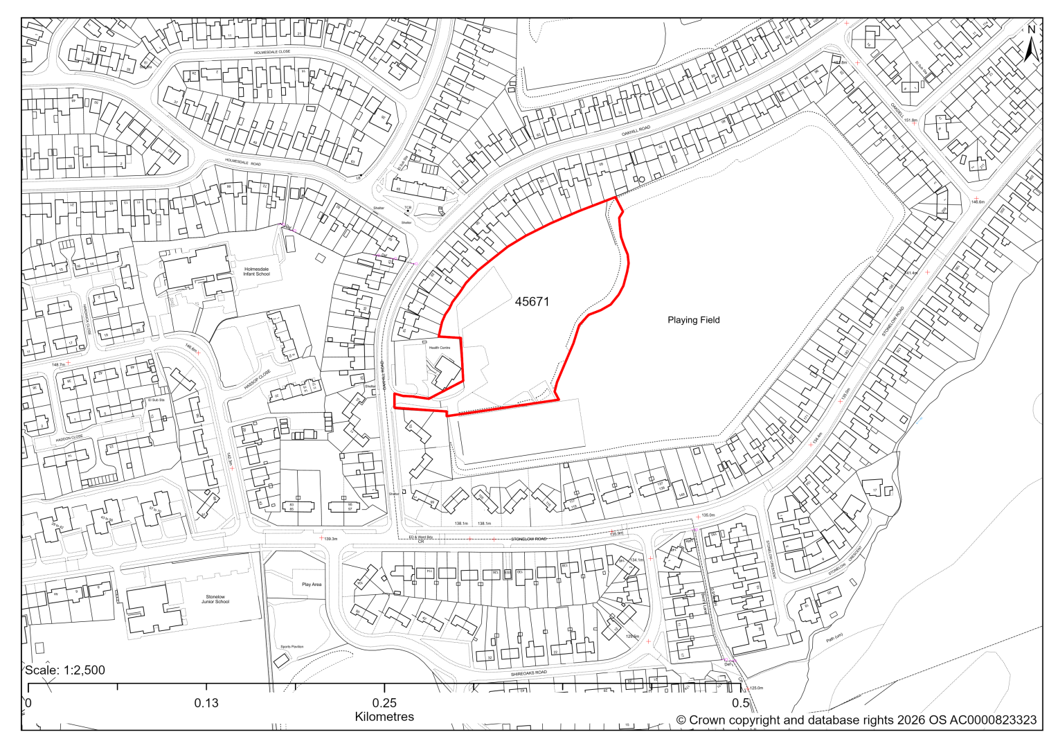
45671 – Gladys Buxton Adult Education Centre, Oakhill Road, Dronfield
The site has planning permission for 27 dwellings. At our 2025 monitoring, construction had yet to commence. 2026 monitoring information is not available yet. We are intending to allocate any major sites with planning permission, if there is a remaining capacity of 10 or more dwellings that have not been completed yet.
45438 – Land off Callywhite Lane, Dronfield
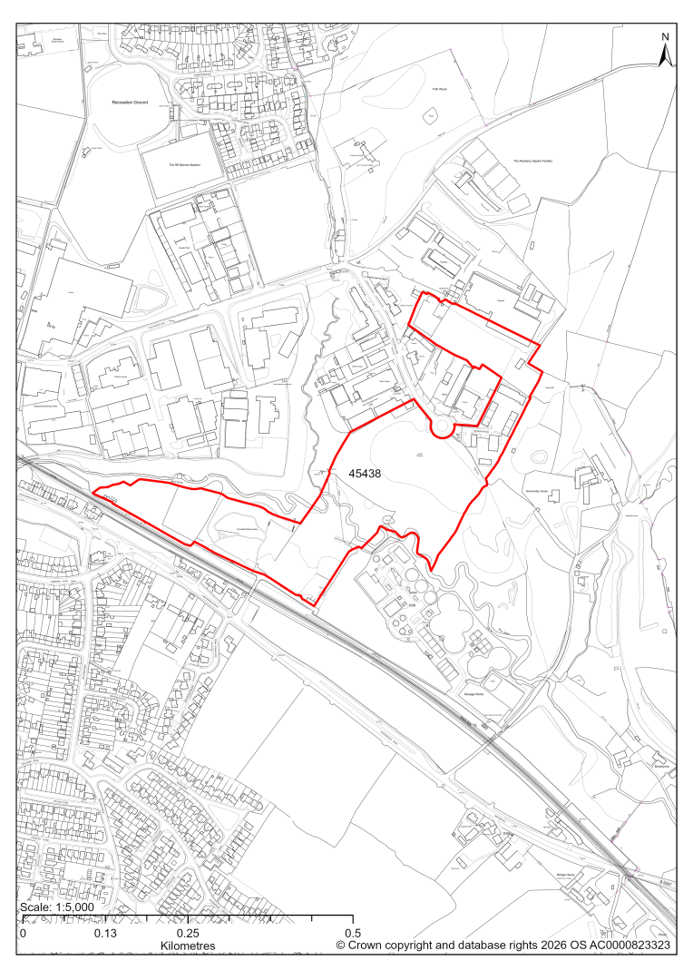
45438 – Land off Callywhite Lane, Dronfield
- This site comprises approximately 9 hectares of land lying to the east and south of the existing Callywhite Lane Industrial Estate at Dronfield which is identified as a ‘Regeneration Area’ in the current 2014-2034 Local Plan. The site could support employment development.
- Landscape assessment has classified as moderate level impact, and recommends any allocation should focus on the previously developed part of the site, avoiding the River Drone corridor which is an important part of the green infrastructure network extending into the town.
- The site of the former Summerley Colliery and associated coke ovens, which is a Scheduled Monument, lies to the east of the site.
- Desktop ecology assessment has identified areas of woodland, together with scrub and grassland as main habitat types on the site. Ecology advice finds a high impact level of development upon biodiversity, as the central wooded part of the site is protected by Tree Preservation Orders and is designated as a Local Wildlife Site. Protected species could be indirectly impacted. A site visit will be needed in the spring to update the advice.
- Creating access to the eastern part of the site off the existing roundabout within the industrial estate would require some widening resulting in loss of some trees. There is an existing access into the western part of the site from Chesterfield Road over the railway bridge, but major upgrades would be required as the existing road is single carriageway and the bridge is subject to a 3-tonne weight restriction.
- The River Drone flows east to west through the centre of the site. Approximately 35% of the site falls within Flood Zones 2 and 3, which will need to be excluded from the developable area.
- There is some risk of surface water flooding on the site.
- A Public Right of Way crosses the site adjacent to the existing employment development on the north eastern part of the site.
- The site is located within the coal authority development high risk area.
If this site were taken forward as an employment allocation, mitigation measures for the above constraints will need to be considered and any Local Plan policy text should include the requirement to address and mitigate the constraints listed above.
Eckington
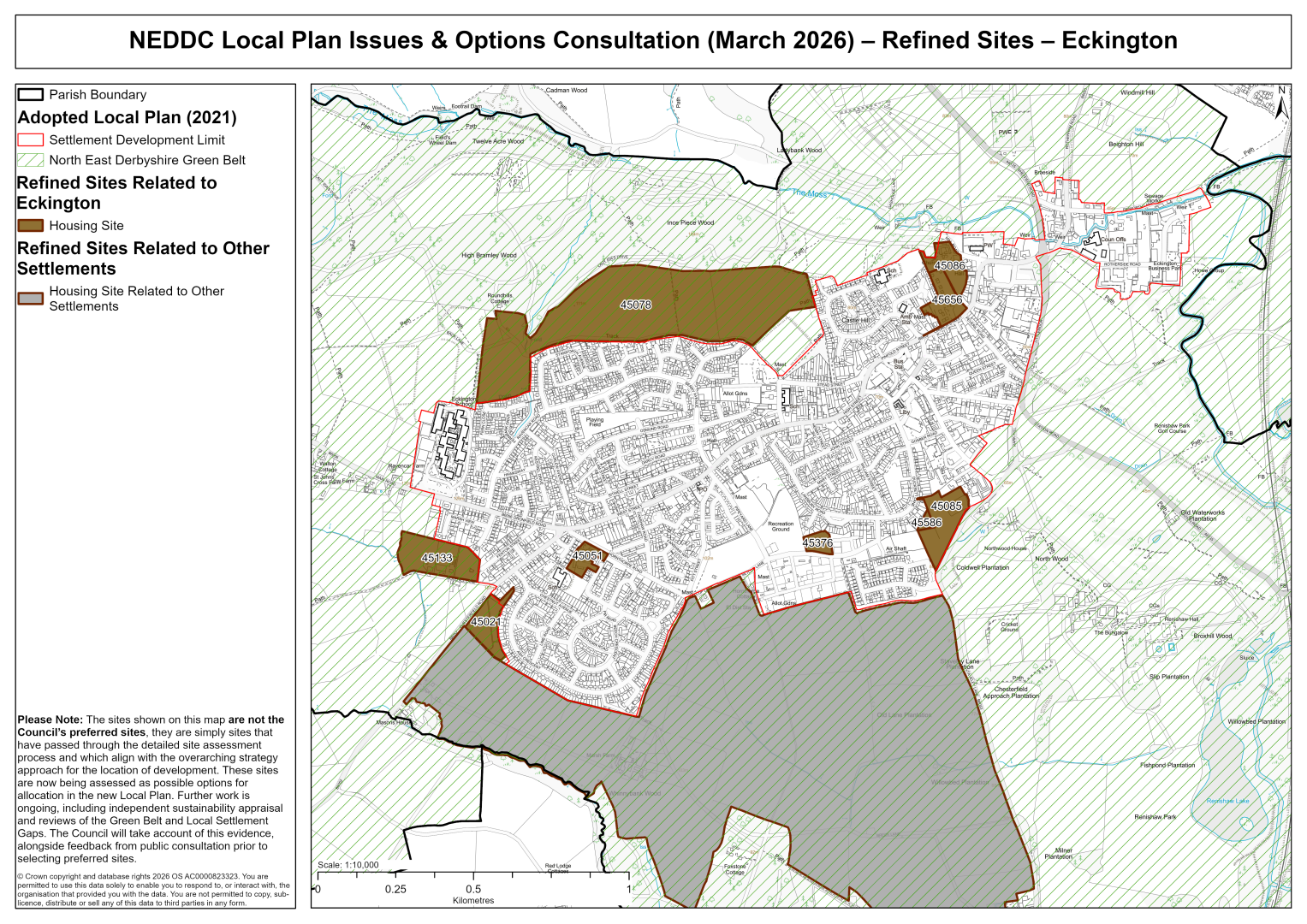
45021 – Land off Chesterfield Road, Eckington
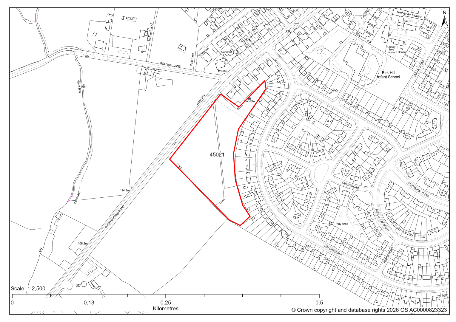
45021 – Land off Chesterfield Road, Eckington
- This site may be able to support approximately 57 dwellings, based on prevailing neighbouring densities, and a 20% density uplift for towns and cities. Mitigation measures have not been applied to this site capacity yet and may result in an altered total.
- Site promoters are interested in using the land for self and custom housebuilding.
- The site is located within the Green Belt and will be assessed through a new Green Belt Review to identify the extent to which the site meets Green Belt purposes a, b & d (related to checking unrestricted sprawl, preventing neighbouring towns merging and preserving the setting and special character of historic towns). The review will identify whether the site is Grey Belt and will inform decisions over whether, or not, Green Belt boundaries should be amended to account for development needs – as required by the National Planning Policy Framework (2024).
- For information, the 2016/17 Green Belt Review showed that this site (which aligns with GB land parcel : ECK/GB/022) performed moderately against Green Belt purposes a & b and weaker against purpose d. Please note: the new Green Belt Review will follow the detailed methodology set out in recent National Planning Practice Guidance, which differs to the approach taken in the 2016/17 review, in terms of assessment criteria and what can be considered to be a town). For this reason, the land parcel results may differ.
- Landscape assessment is yet to take place.
- Ecology assessment finds a low/moderate impact, but recommends that hedgerows and trees are protected.
- Satisfactory highway access can be achieved subject to visibility splays.
- Natural England’s provisional agricultural land classification of the area is grade 3.
- The site is located within coal authority development high risk area.
If this site were to be taken forward as an allocation, mitigation measures for the above constraints will need to be considered and any Local Plan policy text should include the requirement to address and mitigate the constraints listed above.
45051 – EMH Care and Support Limited, Cherry Tree House, Cedar Close, Eckington
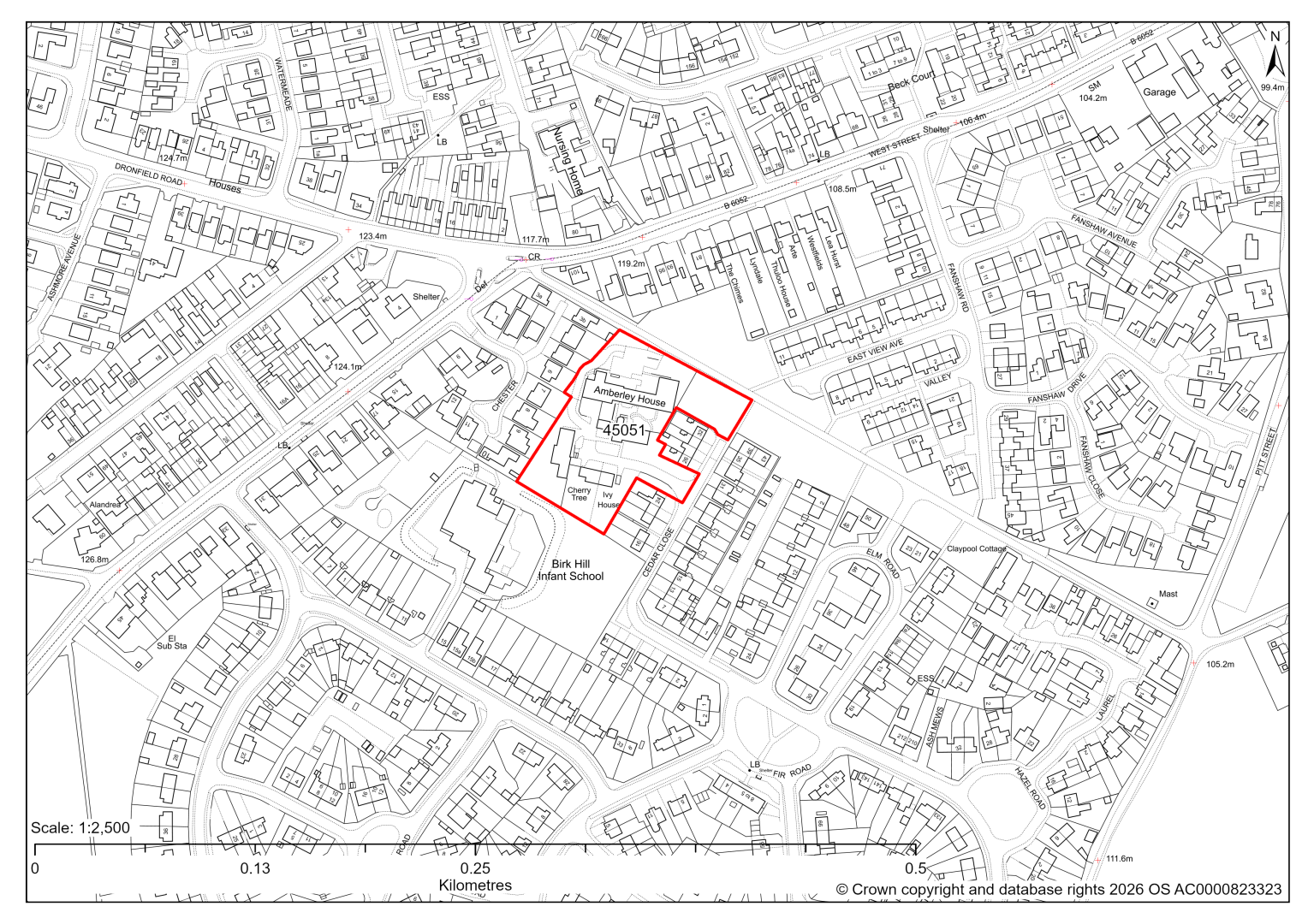
45051 – EMH Care and Support Limited, Cherry Tree House, Cedar Close, Eckington
- This site may be able to support approximately 24 dwellings, based on prevailing neighbouring densities, and a 20% density uplift for towns and cities. Mitigation measures have not been applied to this site capacity yet and may result in an altered total.
- The site currently contains vacant care home facilities and vacant respite care facilities. Redevelopment for residential development would result in the loss of this social infrastructure. Further assessment is needed to establish whether these facilities are no longer viable, needed or valued.
- Highway access may need to be confirmed further.
- Ecology assessment finds a low/moderate impact, but recommends that hedgerows and trees are protected.
- A small north eastern area falls within an urban green space designation around Hornthorpe Road and should be protected.
- There is some risk of surface water flooding on the site.
If this site were to be taken forward as an allocation, mitigation measures for the above constraints will need to be considered and any Local Plan policy text should include the requirement to address and mitigate the constraints listed above.
45078 – Land North of Eckington
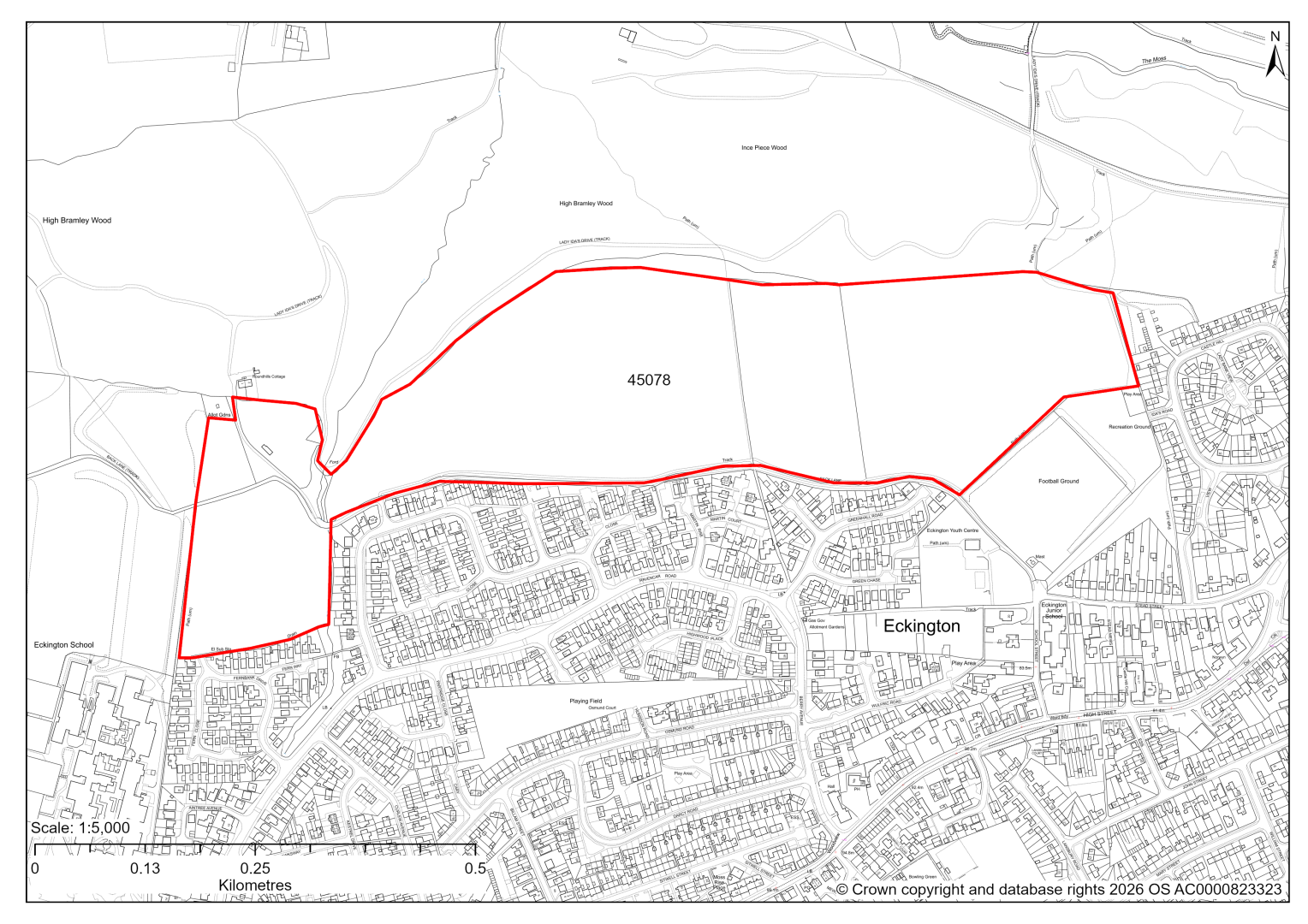
45078 – Land North of Eckington
- This site may be able to support approximately 500 dwellings, based on prevailing neighbouring densities, and a 20% density uplift for towns and cities. Mitigation measures have not been applied to this site capacity yet and may result in an altered total.
- The site is located within the Green Belt and will be assessed through a new Green Belt Review to identify the extent to which the site meets Green Belt purposes a, b & d (related to checking unrestricted sprawl, preventing neighbouring towns merging and preserving the setting and special character of historic towns). The review will identify whether the site is Grey Belt and will inform decisions over whether, or not, Green Belt boundaries should be amended to account for development needs – as required by the National Planning Policy Framework (2024).
- For information, the 2016/17 Green Belt Review showed that this site (which covers the entirety of GB land parcels ECK/GB/031 and ECK/GB/029A) performed moderately against Green Belt purpose a, strongly against purpose b and weakly against purpose d. Please note: the new Green Belt Review will follow the detailed methodology set out in recent National Planning Practice Guidance, which differs to the approach taken in the 2016/17 review, in terms of assessment criteria and what can be considered to be a town). For this reason, the land parcel results may differ.
- Development on the site may have a moderate landscape impact.
- The site is located within the Moss Valley Conservation Area, and adjacent to the medieval Eckington deer park and historic Plumbley Colliery/scheduled Seldom Seen Engine House.
- Desktop ecology advice for the entire site finds a medium/high impact level of development upon biodiversity, as the site shares a border with ancient semi-natural woodland (irreplaceable habitat) and Local Wildlife Site. There is a risk that development could result in deterioration of the ancient woodland. Protected species could be indirectly impacted. A site visit will be needed in the spring to update the advice.
- Highway access may need to be confirmed further.
- There is some risk of surface water flooding on the site.
- Public Rights of Way and proposed cycle routes and greenways cross the site.
- Natural England’s provisional agricultural land classification of the area is grade 3.
- The site is located within coal authority development high risk area.
If this site were to be taken forward as an allocation, mitigation measures for the above constraints will need to be considered and any Local Plan policy text should include the requirement to address and mitigate the constraints listed above.
45085 – East of Ducksett Lane and west of Staveley Lane, Eckington
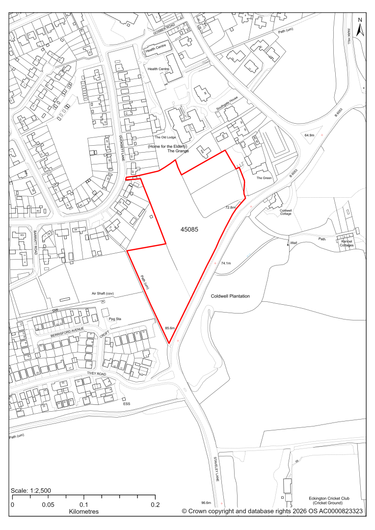
45085 – East of Ducksett Lane and west of Staveley Lane, Eckington
- This site may be able to support approximately 60 dwellings, based on prevailing neighbouring densities, and a 20% density uplift for towns and cities. Mitigation measures have not been applied to this site capacity yet and may result in an altered total.
- Part of the site is within the Eckington and Renishaw Conservation Area, abutting the site to the north east is The Green, a Grade II listed building and on the opposite side of the road Coldwell Cottage also a Grade II listed building. Directly to the east of the site is the Grade I listed Renishaw Hall and the Grade II* listed stable courtyard located within the Grade II* registered Renishaw Hall Park and Gardens.
- Ecology assessment finds a low/moderate impact. It recommends that hedgerows and tree lines are of most value but could be retained.
- Highway access may need to be confirmed further.
- There is some risk of surface water flooding on the site.
- Public Rights of Way cross the site.
- Natural England’s provisional agricultural land classification of the area is grade 3.
If this site were to be taken forward as an allocation, mitigation measures for the above constraints will need to be considered and any Local Plan policy text should include the requirement to address and mitigate the constraints listed above.
45086 – Land off Church Street and Mill Road, Eckington
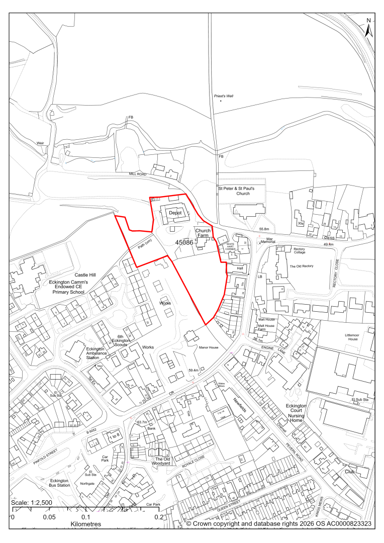
45086 – Land off Church Street and Mill Road, Eckington
- This site may be able to support approximately 25 dwellings, based on prevailing neighbouring densities, and a 20% density uplift for towns and cities. Mitigation measures have not been applied to this site capacity yet and may result in an altered total.
- The site is located within both Eckington and Renishaw Conservation Area and Moss Valley Conservation Area; and nearby several Listed Buildings.
- Ecology assessment finds a low/moderate impact. It recommends that hedgerows and tree lines are of most value but could be retained.
- Highway access may need to be confirmed further.
- A Public Rights of Way crosses the site.
- The site is located within coal authority development high risk area.
If this site were to be taken forward as an allocation, mitigation measures for the above constraints will need to be considered and any Local Plan policy text should include the requirement to address and mitigate the constraints listed above.
45133 – Land off Bolehill Lane, Eckington
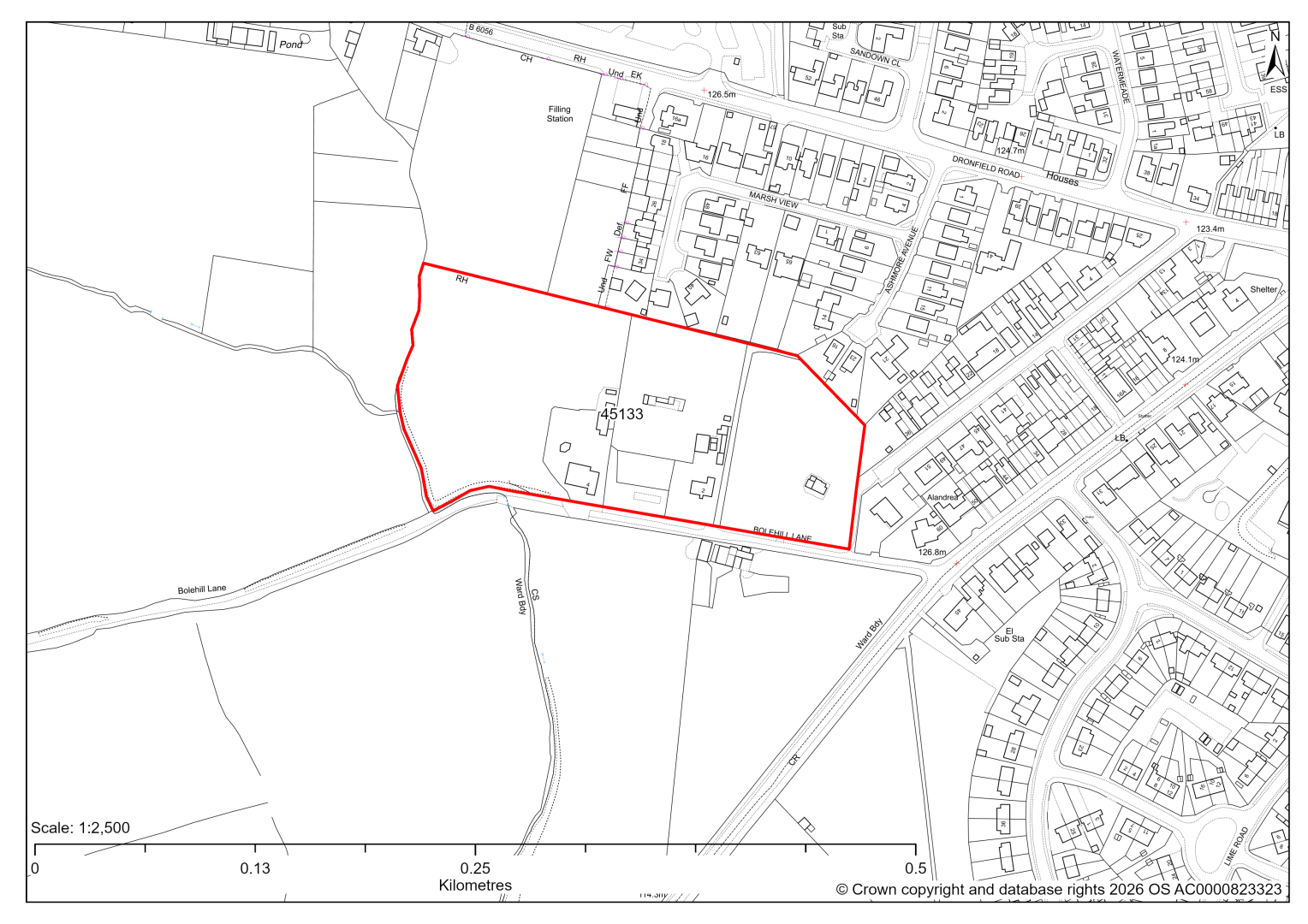
45133 – Land off Bolehill Lane, Eckington
- This site may be able to support approximately 80 dwellings, based on prevailing neighbouring densities, and a 20% density uplift for towns and cities. Mitigation measures have not been applied to this site capacity yet and may result in an altered total.
- The site is located within the Green Belt and will be assessed through a new Green Belt Review to identify the extent to which the site meets Green Belt purposes a, b & d (related to checking unrestricted sprawl, preventing neighbouring towns merging and preserving the setting and special character of historic towns). The review will identify whether the site is Grey Belt and will inform decisions over whether, or not, Green Belt boundaries should be amended to account for development needs – as required by the National Planning Policy Framework (2024).
- For information, the 2016/17 Green Belt Review showed that this site (which covers the entirety of GB land parcels ECK/GB/024 and ECK/GB/025) performed moderately against purposes a & b and weakly against purpose d. Please note: the new Green Belt Review will follow the detailed methodology set out in recent National Planning Practice Guidance, which differs to the approach taken in the 2016/17 review, in terms of assessment criteria and what can be considered to be a town). For this reason, the land parcel results may differ.
- Highway access may need to be confirmed further.
- There is some risk of surface water flooding on the site.
- Natural England’s provisional agricultural land classification of the area is grade 3.
- The site is located within coal authority development high risk area.
If this site were to be taken forward as an allocation, mitigation measures for the above constraints will need to be considered and any Local Plan policy text should include the requirement to address and mitigate the constraints listed above.
45376 – Land between Albert Street and Setcup Lane, Eckington
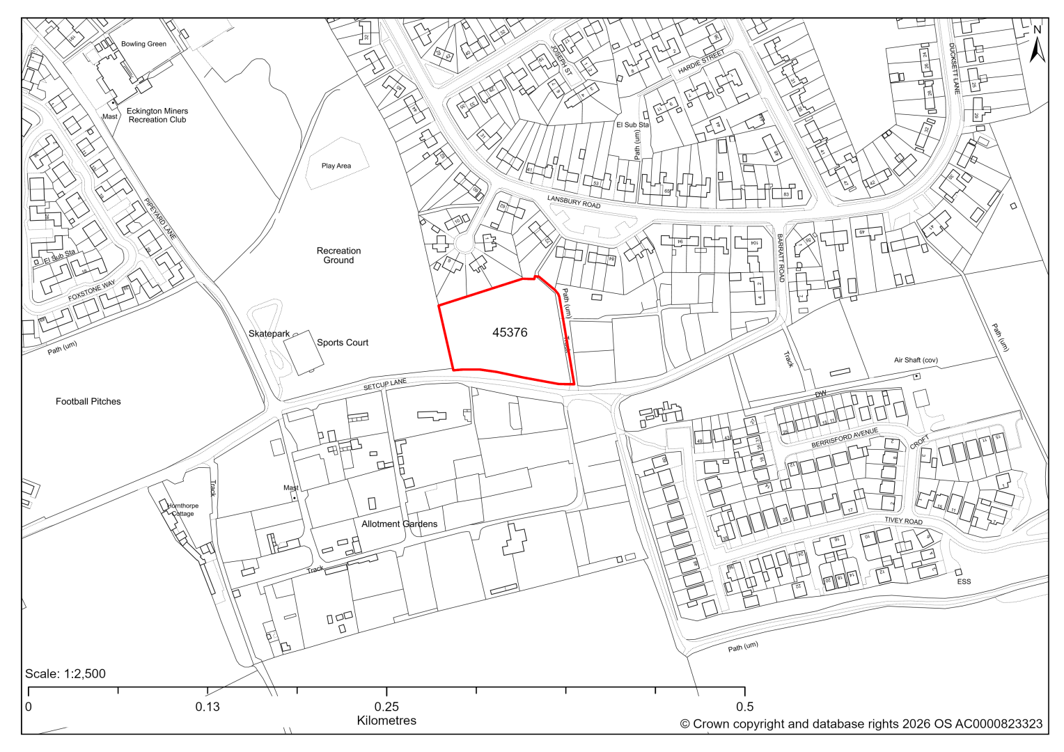
45376 – Land between Albert Street and Setcup Lane, Eckington
- This site may be able to support approximately 20 dwellings, based on prevailing neighbouring densities, and a 20% density uplift for towns and cities. Mitigation measures have not been applied to this site capacity yet and may result in an altered total.
- Highway access may need to be confirmed further.
- Ecology assessment is yet to take place.
- Archaeological assessment is yet to take place.
- Natural England’s provisional agricultural land classification of the area is grade 3.
If this site were to be taken forward as an allocation, mitigation measures for the above constraints will need to be considered and any Local Plan policy text should include the requirement to address and mitigate the constraints listed above.
45586 – Land to the rear of 31 to 41 Ducksett Lane, Eckington
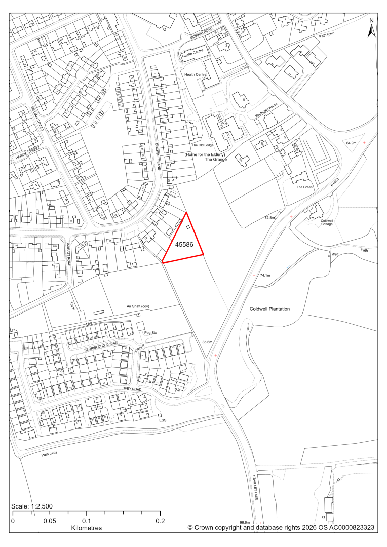
45586 – Land to the rear of 31 to 41 Ducksett Lane, Eckington
- This site may be able to support approximately 6 dwellings, based on prevailing neighbouring densities, and a 20% density uplift for towns and cities. Mitigation measures have not been applied to this site capacity yet and may result in an altered total.
- The minor site could be combined with site 45085.
- Archaeological assessment yet to take place.
- The site does not have any direct access to an adopted highway, but could be combined with site 45085 to the south.
- Ecology assessment is yet to take place, but impact is likely similar to neighbouring site 45085, which finds a low/moderate impact. It recommends that hedgerows and tree lines are of most value but could be retained.
- Natural England’s provisional agricultural land classification of the area is grade 3.
If this site were to be taken forward as an allocation, mitigation measures for the above constraints will need to be considered and any Local Plan policy text should include the requirement to address and mitigate the constraints listed above.
45656 – Bradley Lomas Electrolok Ltd, Church Street, Eckington
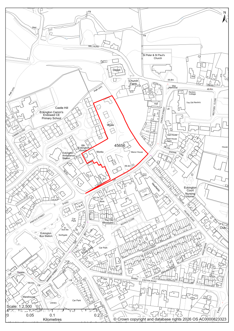
45656 – Bradley Lomas Electrolok Ltd, Church Street, Eckington
The site has planning permission for 20 dwellings. At our 2025 monitoring, construction had not yet completed. 2026 monitoring information is not available yet. We are intending to allocate any major sites with planning permission, if there is a remaining capacity of 10 or more dwellings that have not been completed yet.
Killamarsh
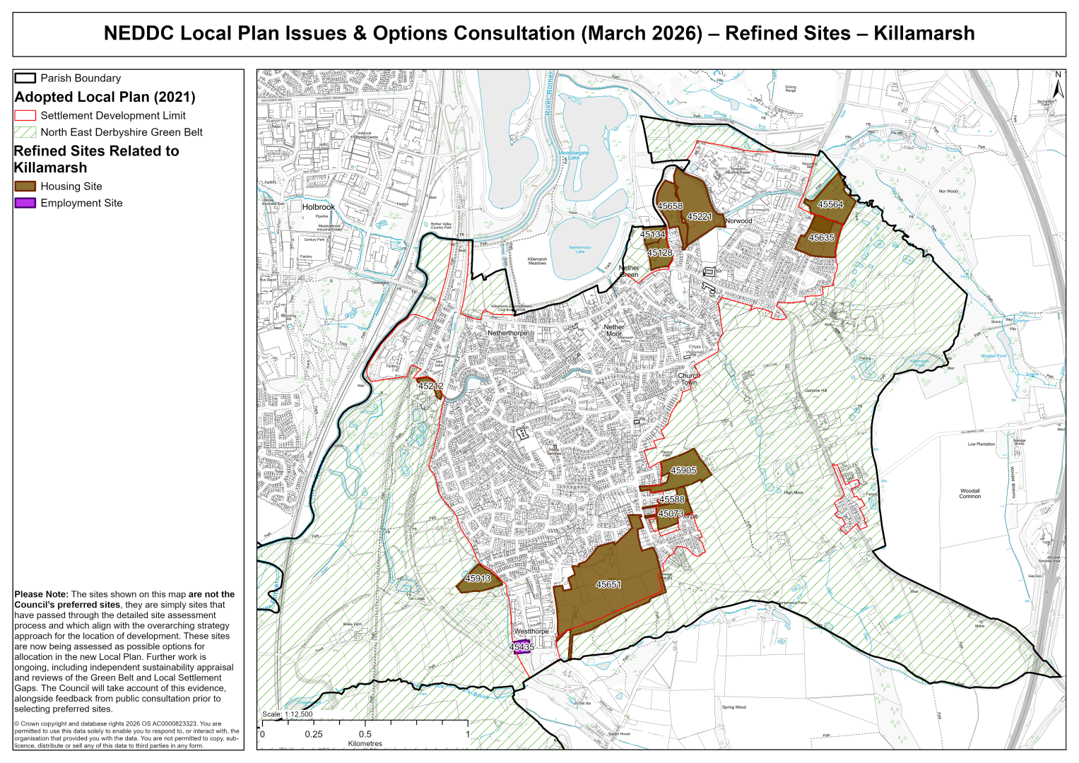
45073 – Land off Upperthorpe Road, Killamarsh
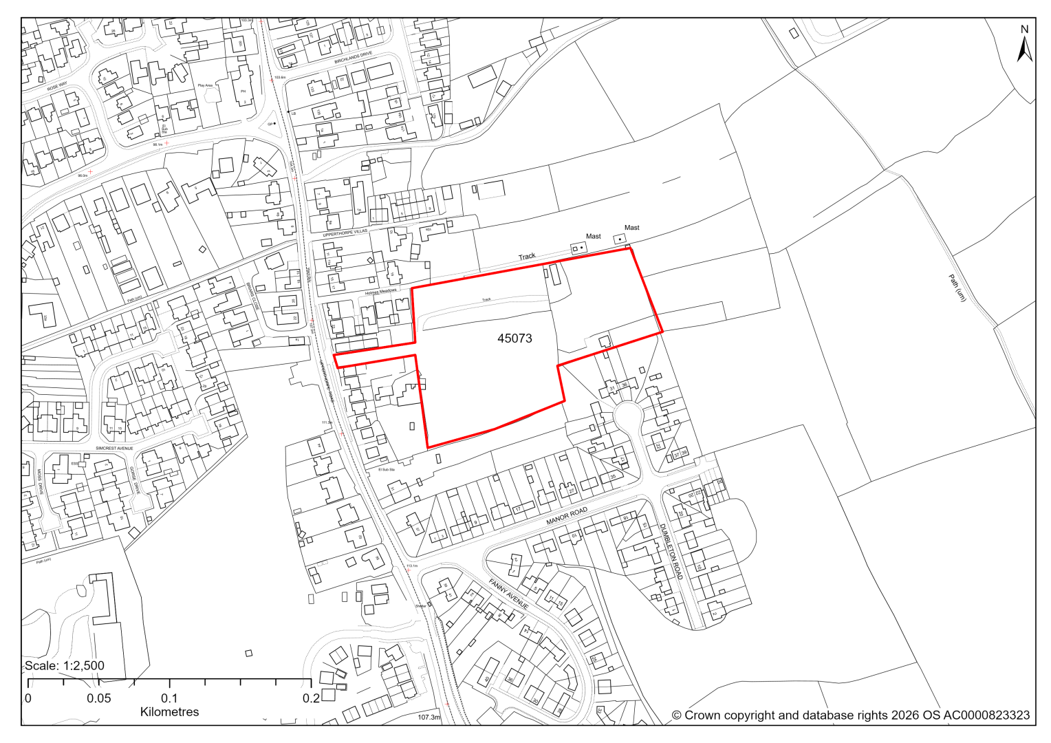
45073 – Land off Upperthorpe Road, Killamarsh
- This site may be able to support approximately 60 dwellings, based on prevailing neighbouring densities, and a 20% density uplift for towns and cities. Mitigation measures have not been applied to this site capacity yet and may result in an altered total.
- The site is located within the Green Belt and will be assessed through a new Green Belt Review to identify the extent to which the site meets Green Belt purposes a, b & d (related to checking unrestricted sprawl, preventing neighbouring towns merging and preserving the setting and special character of historic towns). The review will identify whether the site is Grey Belt and will inform decisions over whether, or not, Green Belt boundaries should be amended to account for development needs – as required by the National Planning Policy Framework (2024).
- For information, the 2016/17 Green Belt Review showed that this site (which lies with the centre of GB land parcel: KIL/GB/021) performed moderately against Green Belt purpose b and weaker against purposes a & d. Please note: the new Green Belt Review will follow the detailed methodology set out in recent National Planning Practice Guidance, which differs to the approach taken in the 2016/17 review, in terms of assessment criteria and what can be considered to be a town). For this reason, the land parcel results may differ.
- Highway access may need to be confirmed further.
- The site is located within coal authority development high risk area.
If this site were to be taken forward as an allocation, mitigation measures for the above constraints will need to be considered and any Local Plan policy text should include the requirement to address and mitigate the constraints listed above.
45588 – Land to the rear of Upperthorpe Villas, Upperthorpe Road, Killamarsh
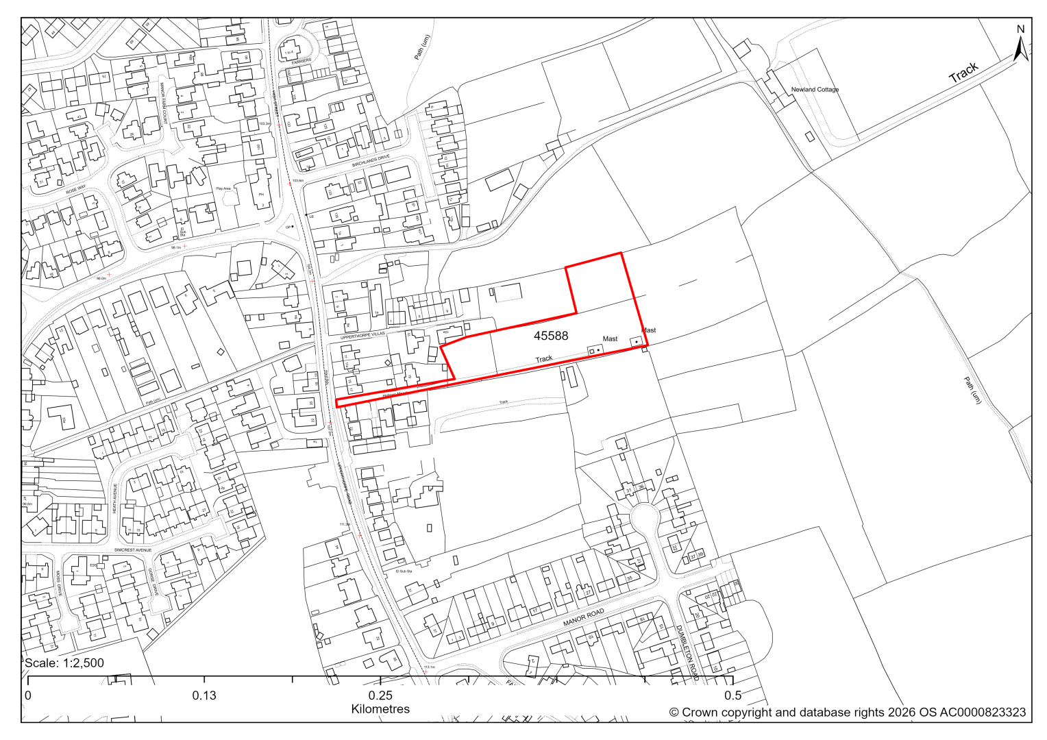
45588 – Land to the rear of Upperthorpe Villas, Upperthorpe Road, Killamarsh
- This site may be able to support approximately 25 dwellings, based on prevailing neighbouring densities, and a 20% density uplift for towns and cities. Mitigation measures have not been applied to this site capacity yet and may result in an altered total.
- The site is located within the Green Belt and will be assessed through a new Green Belt Review to identify the extent to which the site meets Green Belt purposes a, b & d (related to checking unrestricted sprawl, preventing neighbouring towns merging and preserving the setting and special character of historic towns). The review will identify whether the site is Grey Belt and will inform decisions over whether, or not, Green Belt boundaries should be amended to account for development needs – as required by the National Planning Policy Framework (2024).
- For information, the 2016/17 Green Belt Review showed that this site (which lies within GB land parcel: KL/GB/021) performed weaker against Green Belt purposes a & d and moderately against purpose b. Please note: the new Green Belt Review will follow the detailed methodology set out in recent National Planning Practice Guidance, which differs to the approach taken in the 2016/17 review, in terms of assessment criteria and what can be considered to be a town). For this reason, the land parcel results may differ.
- Highway access may need to be confirmed further.
- The site is located within coal authority development high risk area.
If this site were to be taken forward as an allocation, mitigation measures for the above constraints will need to be considered and any Local Plan policy text should include the requirement to address and mitigate the constraints listed above.
45905 – Land east of Upperthorpe Road, Killamarsh
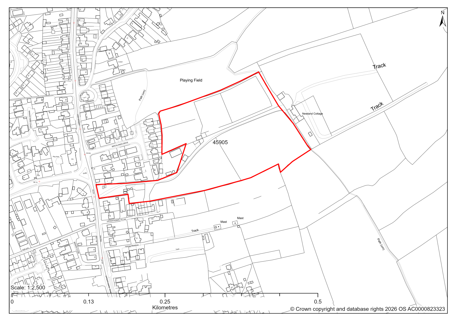
45905 – Land east of Upperthorpe Road, Killamarsh
- This site may be able to support approximately 110 dwellings, based on prevailing neighbouring densities, and a 20% density uplift for towns and cities. Mitigation measures have not been applied to this site capacity yet and may result in an altered total.
- The site is located within the Green Belt and will be assessed through a new Green Belt Review to identify the extent to which the site meets Green Belt purposes a, b & d (related to checking unrestricted sprawl, preventing neighbouring towns merging and preserving the setting and special character of historic towns). The review will identify whether the site is Grey Belt and will inform decisions over whether, or not, Green Belt boundaries should be amended to account for development needs – as required by the National Planning Policy Framework (2024).
- For information, the 2016/17 Green Belt Review showed that this site (which covers the entirety of GB land parcel KIL/GB/019 and a large part of parcel KIL/GB/018) performed strongly against Green Belt purposes a & b and weaker against purpose d. Please note: the new Green Belt Review will follow the detailed methodology set out in recent National Planning Practice Guidance, which differs to the approach taken in the 2016/17 review, in terms of assessment criteria and what can be considered to be a town). For this reason, the land parcel results may differ.
- Desktop ecology advice finds a medium impact level of development upon biodiversity. A site visit will be needed in the spring.
- Highway access may need to be confirmed further.
- Less than 1% of the site is at some risk of surface water flooding.
- Public Rights of Way cross the site.
- The site is located within coal authority development high risk area.
If this site were to be taken forward as an allocation, mitigation measures for the above constraints will need to be considered and any Local Plan policy text should include the requirement to address and mitigate the constraints listed above.
45128 – Moor House Farm, East of Barber’s Lane, Killamarsh
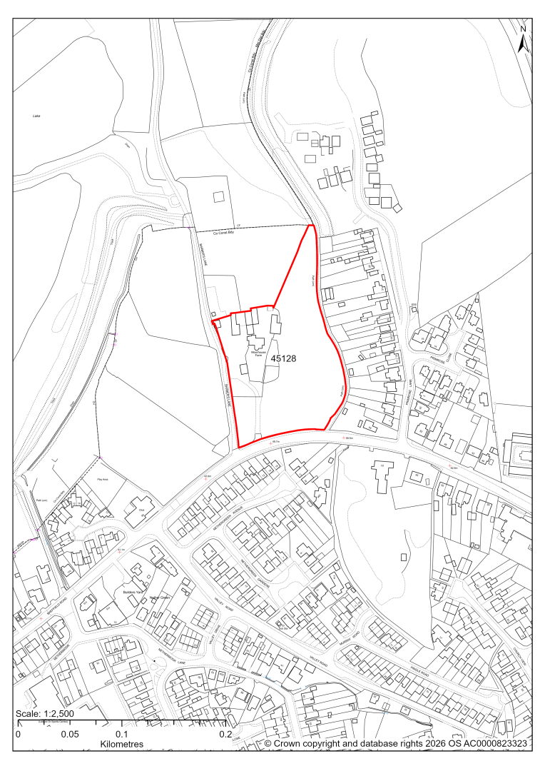
45128 – Moor House Farm, East of Barber’s Lane, Killamarsh
- This site may be able to support approximately 50 dwellings, based on prevailing neighbouring densities, and a 20% density uplift for towns and cities. Mitigation measures have not been applied to this site capacity yet and may result in an altered total.
- The site is located within the Green Belt and will be assessed through a new Green Belt Review to identify the extent to which the site meets Green Belt purposes a, b & d (related to checking unrestricted sprawl, preventing neighbouring towns merging and preserving the setting and special character of historic towns). The review will identify whether the site is Grey Belt and will inform decisions over whether, or not, Green Belt boundaries should be amended to account for development needs – as required by the National Planning Policy Framework (2024).
- For information, the 2016/17 Green Belt Review showed that this site (which lies within GB land parcel : KIL/GB/002) performed moderately against Green Belt purposes a & b and weaker against purpose d. Please note: the new Green Belt Review will follow the detailed methodology set out in recent National Planning Practice Guidance, which differs to the approach taken in the 2016/17 review, in terms of assessment criteria and what can be considered to be a town). For this reason, the land parcel results may differ.
- The route of the Chesterfield Canal borders the site. Any future development proposals should make a positive contribution to the restoration and enhancement of the canal; and be coordinated in line with the Chesterfield Canal Corridor Masterplan. In particular, it should not prejudice the options for the canal to ascend the approximate 21m between Nethermoor Lake and Primrose Lane.
- Highway access may need to be confirmed further.
- There is some risk of surface water flooding on the site.
- The site is located within coal authority development high risk area.
If this site were to be taken forward as an allocation, mitigation measures for the above constraints will need to be considered and any Local Plan policy text should include the requirement to address and mitigate the constraints listed above.
45134 – Land to the north of Moor House Farm, Barber's Lane, Killamarsh
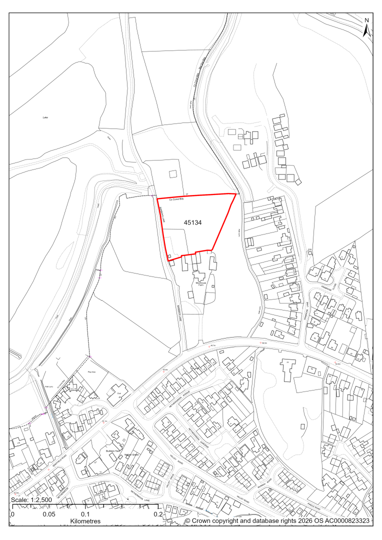
45134 – Land to the north of Moor House Farm, Barber's Lane, Killamarsh
- This site may be able to support approximately 25 dwellings, based on prevailing neighbouring densities, and a 20% density uplift for towns and cities. Mitigation measures have not been applied to this site capacity yet and may result in an altered total.
- The site is located within the Green Belt and will be assessed through a new Green Belt Review to identify the extent to which the site meets Green Belt purposes a, b & d (related to checking unrestricted sprawl, preventing neighbouring towns merging and preserving the setting and special character of historic towns). The review will identify whether the site is Grey Belt and will inform decisions over whether, or not, Green Belt boundaries should be amended to account for development needs – as required by the National Planning Policy Framework (2024)
- For information, the 2016/17 Green Belt Review showed that this site (which lies within a smaller part of GB land parcel: KIL/GB/002) performed moderately against Green Belt purposes a & b and weaker against purpose d. Please note: the new Green Belt Review will follow the detailed methodology set out in recent National Planning Practice Guidance, which differs to the approach taken in the 2016/17 review, in terms of assessment criteria and what can be considered to be a town). For this reason, the land parcel results may differ.
- The route of the Chesterfield Canal borders the site. Any future development proposals should make a positive contribution to the restoration and enhancement of the canal; and be coordinated in line with the Chesterfield Canal Corridor Masterplan. In particular, it should not prejudice the options for the canal to ascend the approximate 21m between Nethermoor Lake and Primrose Lane.
- Highway access may need to be confirmed further.
- Approximately 29% of the site is located within flood risk zone 2, in the north west of the site.
- Natural England’s provisional agricultural land classification of the area is grade 3.
- The site is located within coal authority development high risk area.
If this site were to be taken forward as an allocation, mitigation measures for the above constraints will need to be considered and any Local Plan policy text should include the requirement to address and mitigate the constraints listed above.
45212 – Land north of Field Lane, Killamarsh
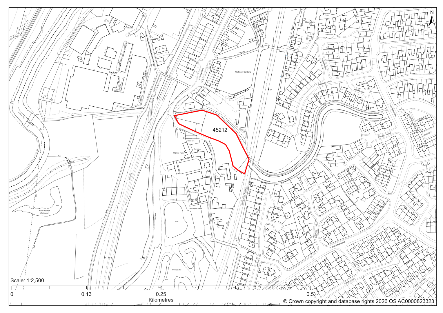
45212 – Land north of Field Lane, Killamarsh
- This site may be able to support approximately 25 dwellings, based on prevailing neighbouring densities, and a 20% density uplift for towns and cities. Mitigation measures have not been applied to this site capacity yet and may result in an altered total.
- The site is located within the Green Belt and will be assessed through a new Green Belt Review to identify the extent to which the site meets Green Belt purposes a, b & d (related to checking unrestricted sprawl, preventing neighbouring towns merging and preserving the setting and special character of historic towns). The review will identify whether the site is Grey Belt and will inform decisions over whether, or not, Green Belt boundaries should be amended to account for development needs – as required by the National Planning Policy Framework (2024).
- For information, the 2016/17 Green Belt Review showed that this site (which aligns with GB land parcel: KIL/GB/033) performed moderately against Green Belt purpose a, strongly against purpose b and weaker against purpose d. Please note: the new Green Belt Review will follow the detailed methodology set out in recent National Planning Practice Guidance, which differs to the approach taken in the 2016/17 review, in terms of assessment criteria and what can be considered to be a town). For this reason, the land parcel results may differ.
- The route of the Chesterfield Canal borders the site. Any future development proposals should make a positive contribution to the restoration and enhancement of the canal; and be coordinated in line with the Chesterfield Canal Corridor Masterplan.
- The Chesterfield Canal Trust has put the site forward for possible canal related development, which could include some housing. Availability will need to be confirmed with the landowner.
- Highway access may need to be confirmed further.
If this site were to be taken forward as an allocation, mitigation measures for the above constraints will need to be considered and any Local Plan policy text should include the requirement to address and mitigate the constraints listed above.
45221 – Land off Primrose Lane, Killamarsh
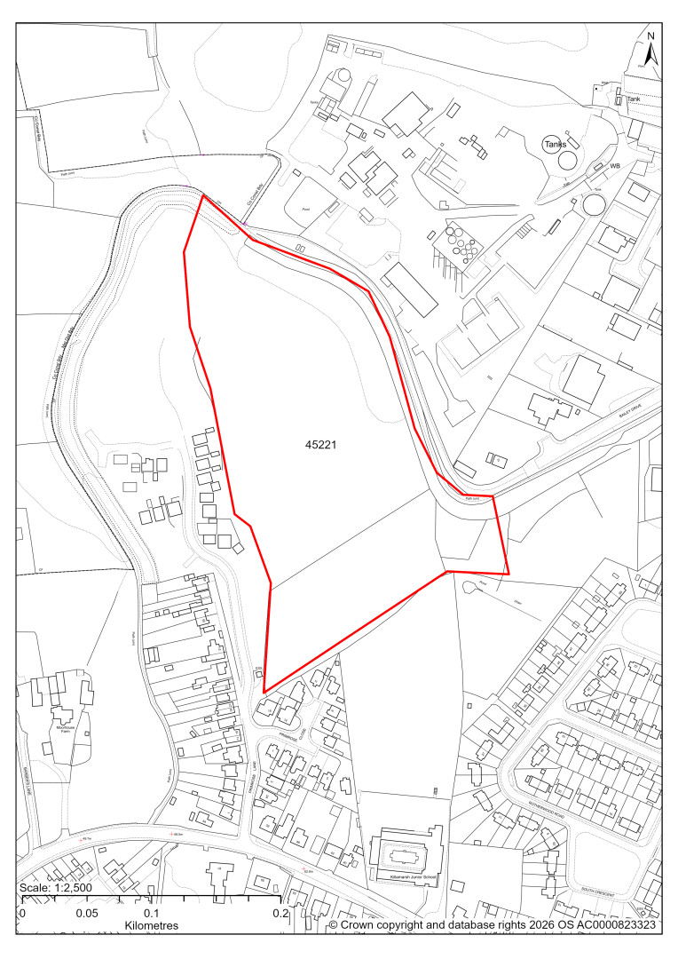
45221 – Land off Primrose Lane, Killamarsh
- This site may be able to support approximately 140 dwellings, based on prevailing neighbouring densities, and a 20% density uplift for towns and cities. Mitigation measures have not been applied to this site capacity yet and may result in an altered total.
- The route of the Chesterfield Canal borders the site. Any future development proposals should make a positive contribution to the restoration and enhancement of the canal; and be coordinated in line with the Chesterfield Canal Corridor Masterplan.
- Archaeological assessment classifies the site as having archaeological / historic environment issues, but might be suitable for allocation with appropriate site specific policy. This is due to the former line of the Chesterfield Canal.
- Ecology assessment finds a moderate/high impact. The site boundary includes part of a Local Wildlife Site around the Chesterfield Canal. The main concern is loss or damage to habitats within the Local Wildlife Site and those supporting the wildlife corridor and providing habitat for protected species. Development would require a substantial buffer to the LWS and Canal.
- Highway access may need to be confirmed further.
- Approximately 8% of the site is located within flood risk zones 2 and 3, in the north west of the site. There are also areas at risk of surface water flooding. All are along the canal route.
- The majority of the site is allocated for employment use in the current 2014-2034 Local Plan. However, evidence within the Employment Needs Assessment 2025 recommends deallocating this site for employment.
- Part of the site is located within the Health and Safety Executive's hazardous risk zone.
- Natural England’s provisional agricultural land classification of the area is grade 3.
- The site is located within coal authority development high risk area.
If this site were to be taken forward as an allocation, mitigation measures for the above constraints will need to be considered and any Local Plan policy text should include the requirement to address and mitigate the constraints listed above.
45658 – Land between Old Canal and North Side of Primrose Lane, Killamarsh
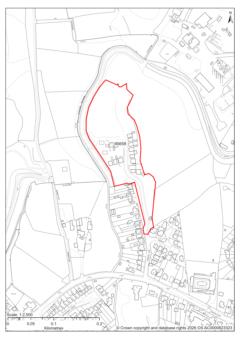
45658 – Land between Old Canal and North Side of Primrose Lane, Killamarsh
The site has planning permission for 50 dwellings. At our 2025 monitoring, another 43 dwellings were yet to be completed. 2026 monitoring information is not available yet. We are intending to allocate any major sites with planning permission, if there is a remaining capacity of 10 or more dwellings that have not been completed yet.
45564 – Navarda Park, Rotherham Road, Killamarsh
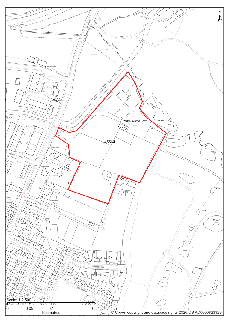
45564 – Navarda Park, Rotherham Road, Killamarsh
- This site may be able to support approximately 80 dwellings, based on prevailing neighbouring densities, and a 20% density uplift for towns and cities. Mitigation measures have not been applied to this site capacity yet and may result in an altered total.
- The site is located within the Green Belt and will be assessed through a new Green Belt Review to identify the extent to which the site meets Green Belt purposes a, b & d (related to checking unrestricted sprawl, preventing neighbouring towns merging and preserving the setting and special character of historic towns). The review will identify whether the site is Grey Belt and will inform decisions over whether, or not, Green Belt boundaries should be amended to account for development needs – as required by the National Planning Policy Framework (2024).
- For information, the 2016/17 Green Belt Review showed that this site (which covers a large part of GB land parcel KIL/GB/005 and a small part of parcel KIL/GB/006) performed strongly against Green Belt purposes a & b and weaker against purpose d. Please note: the new Green Belt Review will follow the detailed methodology set out in recent National Planning Practice Guidance, which differs to the approach taken in the 2016/17 review, in terms of assessment criteria and what can be considered to be a town). For this reason, the land parcel results may differ.
- The 20% of the site that is outwith the Green Belt is also covered by site 45635. The residential capacity has been adjusted to avoid double counting.
- The route of the Chesterfield Canal borders the site. Any future development proposals should make a positive contribution to the restoration and enhancement of the canal; and be coordinated in line with the Chesterfield Canal Corridor Masterplan.
- Archaeological assessment classifies the site as having archaeological/historic environment issues, but might be suitable for allocation with appropriate site specific policy. This is due to the line of the Chesterfield Canal, and a Roman coin findspot.
- Desktop ecology advice for the entire site finds a medium impact level of development upon biodiversity, as the site shares a border with ancient semi-natural woodland and the canal. There is a risk that development could result in deterioration of the ancient woodland. Protected species could be indirectly impacted. A site visit will be needed in the spring to update the advice.
- Highway access may need to be confirmed further.
- Approximately 15% of the site is located within flood risk zones 2 and 3, in the north west of the site. There are also areas at risk of surface water flooding, concentrated in the centre of the site.
- Natural England’s provisional agricultural land classification of the area is grade 3.
- The site is located within coal authority development high risk area.
If this site were to be taken forward as an allocation, mitigation measures for the above constraints will need to be considered and any Local Plan policy text should include the requirement to address and mitigate the constraints listed above.
45635 – Land off Rotherham Road, Killamarsh
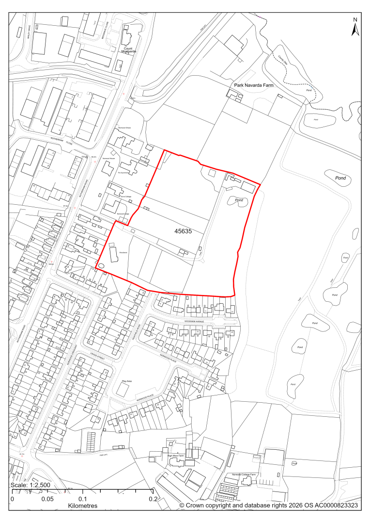
45635 – Land off Rotherham Road, Killamarsh
- This site may be able to support approximately 100 dwellings, based on prevailing neighbouring densities, and a 20% density uplift for towns and cities. Mitigation measures have not been applied to this site capacity yet and may result in an altered total.
- The site is a housing allocation in the current 2014-2034 Local Plan.
- Highway access may need to be confirmed further.
- There is some risk of surface water flooding on the site.
- Natural England’s provisional agricultural land classification of the area is grade 3.
- The site is located within coal authority development high risk area.
If this site were to be taken forward as an allocation again, mitigation measures for the above constraints will need to be considered and any Local Plan policy text should include the requirement to address and mitigate the constraints listed above.
45651 – Land South West of Upperthorpe Road, Killamarsh
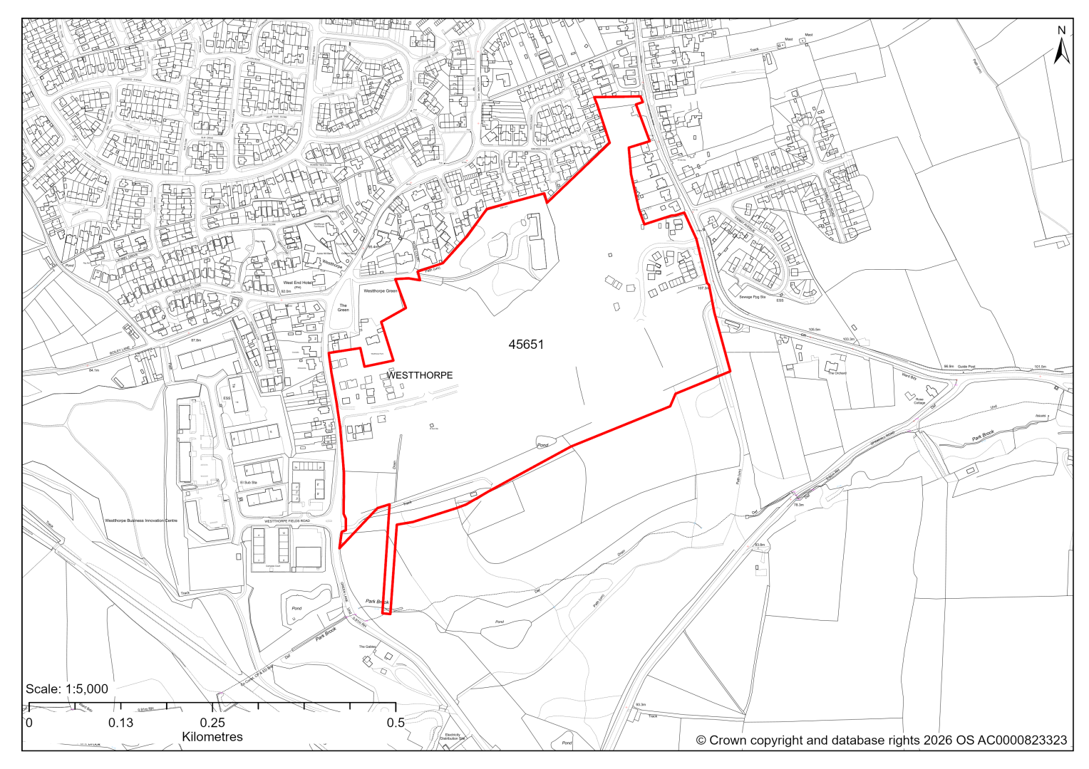
45651 – Land South West of Upperthorpe Road, Killamarsh
- The site has planning permission for 315 dwellings. At our 2025 monitoring, construction had started but no dwellings had been completed yet. 2026 monitoring information is not available yet. We are intending to allocate any major sites with planning permission, if there is a remaining capacity of 10 or more dwellings that have not been completed yet.
- The site is located within the Green Belt and will be assessed through a new Green Belt Review to identify the extent to which the site meets Green Belt purposes a, b & d (related to checking unrestricted sprawl, preventing neighbouring towns merging and preserving the setting and special character of historic towns). The review will identify whether the site is Grey Belt and will inform decisions over whether, or not, Green Belt boundaries should be amended to account for development needs – as required by the National Planning Policy Framework (2024).
- For information, the 2016/17 Green Belt Review showed that this site (which covers a large part of GB land parcel KL/GB/025 and a small part of parcel KIL/GB/024 and KIL/GB/023) performed moderately against Green Belt purposes a & b and weaker against purpose d. Please note: the new Green Belt Review will follow the detailed methodology set out in recent National Planning Practice Guidance, which differs to the approach taken in the 2016/17 review, in terms of assessment criteria and what can be considered to be a town). For this reason, the land parcel results may differ.
45913 – North Side of Boiley Lane, Killamarsh
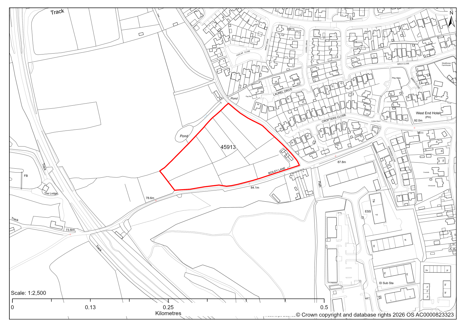
45913 – North Side of Boiley Lane, Killamarsh
- This site may be able to support approximately 50 dwellings, based on prevailing neighbouring densities, and a 20% density uplift for towns and cities. Mitigation measures have not been applied to this site capacity yet and may result in an altered total.
- The site is located within the Green Belt and will be assessed through a new Green Belt Review to identify the extent to which the site meets Green Belt purposes a, b & d (related to checking unrestricted sprawl, preventing neighbouring towns merging and preserving the setting and special character of historic towns). The review will identify whether the site is Grey Belt and will inform decisions over whether, or not, Green Belt boundaries should be amended to account for development needs – as required by the National Planning Policy Framework (2024).
- For information, the 2016/17 Green Belt Review showed that this site (which lies within GB land parcel : KIL/GB/027) performed strongly against Green Belt purposes a & b and weaker against purpose d. Please note: the new Green Belt Review will follow the detailed methodology set out in recent National Planning Practice Guidance, which differs to the approach taken in the 2016/17 review, in terms of assessment criteria and what can be considered to be a town). For this reason, the land parcel results may differ.
- Highway access may need to be confirmed further.
- There is some risk of surface water flooding on the site.
- The site is located within coal authority development high risk area.
If this site were to be taken forward as an allocation, mitigation measures for the above constraints will need to be considered and any Local Plan policy text should include the requirement to address and mitigate the constraints listed above.
45435 – Plot 4 Westhorpe Fields, Westthorpe Fields Road, Killamarsh
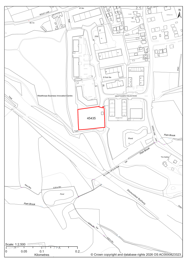
45435 – Plot 4 Westthorpe Fields, Westthorpe Fields Road, Killamarsh
- This site comprises approximately 0.44 hectares of land within the Westthorpe Business Park which is identified as a Principal Employment Area in the current 2014-2034 Local Plan. The site could support employment development.
- The site has detailed planning permission for 10 light industrial units. Application to discharge several conditions pursuant to the permission is pending determination by the council.
- We are intending to allocate sites with planning permission if the development is not yet completed.