NEDDC Local Plan Issues and Options Consultation on the Strategic Approach to the Location of Development and Refined Sites (March 2026)
Priority 2 – Level 2 Settlements – Larger Villages
Calow
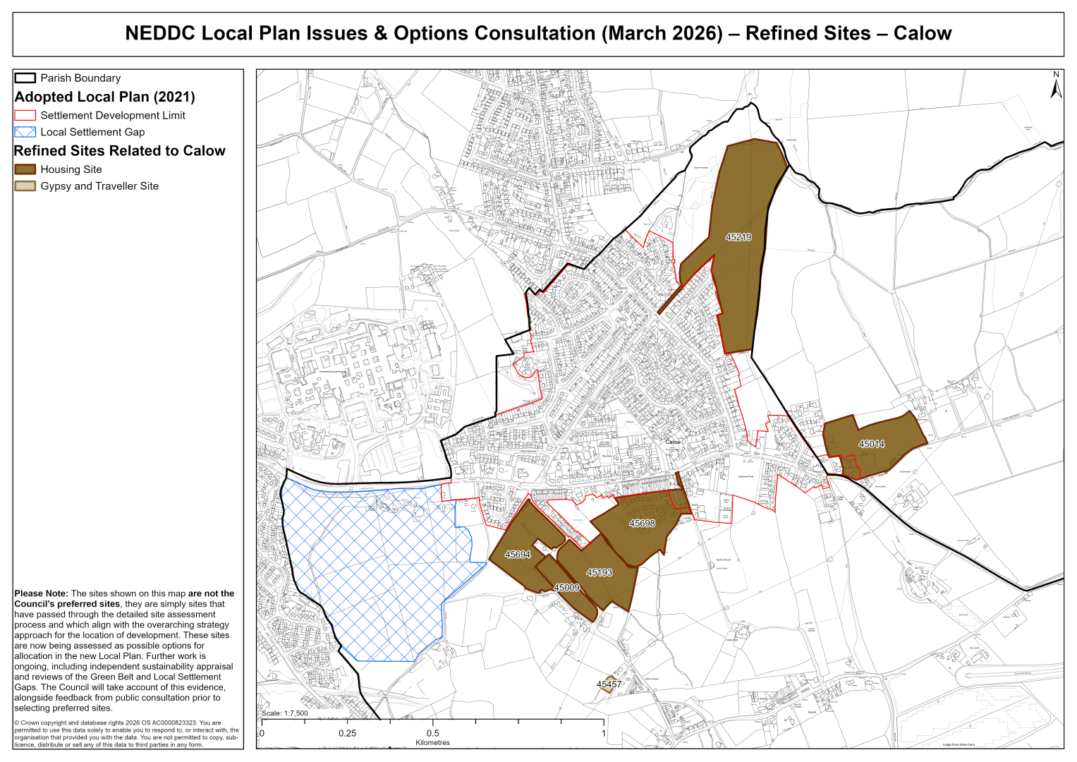
45009 – Land at Top Alley, Dark Lane, Calow
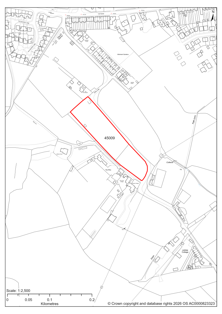
45009 – Land at Top Alley, Dark Lane, Calow
- This site may be able to support approximately 40 dwellings, based on prevailing neighbouring densities, and a 20% density uplift for the most sustainable settlements. Mitigation measures have not been applied to this site capacity yet and may result in an altered total.
- Development on the site may have a moderate landscape impact, in particular as a standalone development.
- The ecology assessment finds a moderate impact. Hedgerows could be adversely affected but can likely be retained. Loss of grassland is unlikely to be avoided.
- Highway access may need to be confirmed further.
- Although the site is more than 50m away from the existing settlement development limit, there are two major permissioned residential developments nearby (45694 and 45698).
- Natural England’s provisional agricultural land classification of the southern area is grade 3.
- The site is located within coal authority development high risk area.
If this site were to be taken forward as an allocation, mitigation measures for the above constraints will need to be considered and any Local Plan policy text should include the requirement to address and mitigate the constraints listed above.
45014 – Duckmanton Lodge, Chesterfield Road, Calow
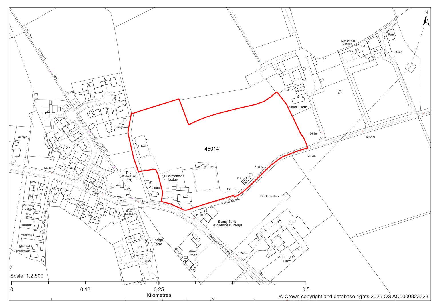
45014 – Duckmanton Lodge, Chesterfield Road, Calow
- This site may be able to support approximately 40 dwellings, based on prevailing neighbouring densities, and a 20% density uplift for the most sustainable settlements. Mitigation measures have not been applied to this site capacity yet and may result in an altered total.
- A planning application for 50 dwellings is currently pending determination by the Council.
- Development on the site may have a moderate landscape impact.
- The site is in close proximity to a Grade II Listed Building.
- The ecology assessment finds a moderate impact, mainly due to some potentially veteran beech trees along the southern boundary.
- Highway access may need to be confirmed further.
- There is some risk of surface water flooding on the site.
- The site was previously used as formal playing pitches. The Current Local Plan continues to protect the site for recreational use. Further evidence that the site is not required anymore will be needed.
- The site is located within coal authority development high risk area.
If this site were to be taken forward as an allocation, mitigation measures for the above constraints will need to be considered and any Local Plan policy text should include the requirement to address and mitigate the constraints listed above.
45193 – Land east of Dark Lane, Calow
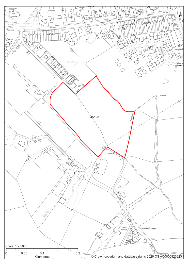
45193 – Land east of Dark Lane, Calow
- This site may be able to support approximately 80 dwellings, based on prevailing neighbouring densities, and a 20% density uplift for the most sustainable settlements. Mitigation measures have not been applied to this site capacity yet and may result in an altered total.
- Development on the site may have a moderate landscape impact.
- Highway access may need to be confirmed further.
- Approximately 1% of the site is located within flood risk zones 2 and 3. There are also areas at risk of surface water flooding, concentrated in the centre and north eastern boundary.
- A Public Right of Way crosses the site.
- There are some pylons and overhead power lines in the south of the site.
- Natural England’s provisional agricultural land classification of the southern area is grade 3.
- The site is located within coal authority development high risk area.
If this site were to be taken forward as an allocation, mitigation measures for the above constraints will need to be considered and any Local Plan policy text should include the requirement to address and mitigate the constraints listed above.
45219 – Land off Freydon Way, Calow
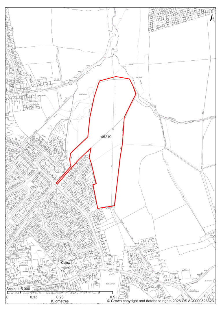
45219 – Land off Freydon Way, Calow
- This site may be able to support approximately 220 dwellings, based on prevailing neighbouring densities, and a 20% density uplift for the most sustainable settlements. Mitigation measures have not been applied to this site capacity yet and may result in an altered total.
- Landscape assessment has classified as moderate level impact, and recommends a smaller allocation area.
- The ecology assessments find a moderate to high impact, in particular in the north of the site, due to the adjacent ancient semi-natural woodland designated as a Local Wildlife Site (in part). It recommends putting a buffer in place to protect the woodland.
- Highway access may need to be confirmed further.
- Approximately 1.5% of the site is at some risk of surface water flooding.
- Public Rights of Way crosses the site.
- There are pylons and overhead power lines crossing the site.
- The site is located within coal authority development high risk area.
If this site were to be taken forward as an allocation, mitigation measures for the above constraints will need to be considered and any Local Plan policy text should include the requirement to address and mitigate the constraints listed above.
45457 – The Old Potato Store, Dark Lane, Calow
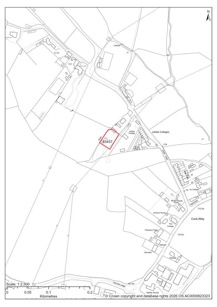
45457 – The Old Potato Store, Dark Lane, Calow
The site has planning permission for 2 traveller pitches. At our 2025 monitoring, construction had not yet completed. 2026 monitoring information is not available yet. We are intending to allocate any sites with planning permission if the development has not been completed yet.
45694 – Land to the north and north west of the Homestead, Dark Lane, Calow
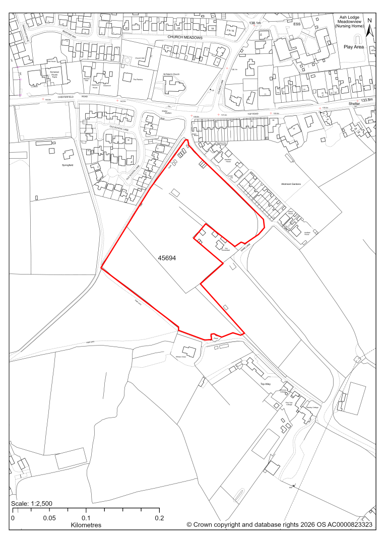
45694 – Land to the north and north west of the Homestead, Dark Lane, Calow
The site has planning permission for 35 dwellings. At our 2025 monitoring, construction had yet to commence. 2026 monitoring information is not available yet. We are intending to allocate any major sites with planning permission, if there is a remaining capacity of 10 or more dwellings that have not been completed yet.
45698 – Land from the east of Dark Lane to the west of Oaks Farm Lane, Calow
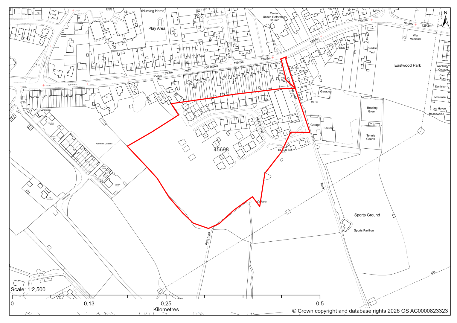
45698 – Land from the east of Dark Lane to the west of Oaks Farm Lane, Calow
The site has planning permission for 75 dwellings. At our 2025 monitoring, construction had started but no dwellings had been completed yet. 2026 monitoring information is not available yet. We are intending to allocate any major sites with planning permission, if there is a remaining capacity of 10 or more dwellings that have not been completed yet.
Grassmoor
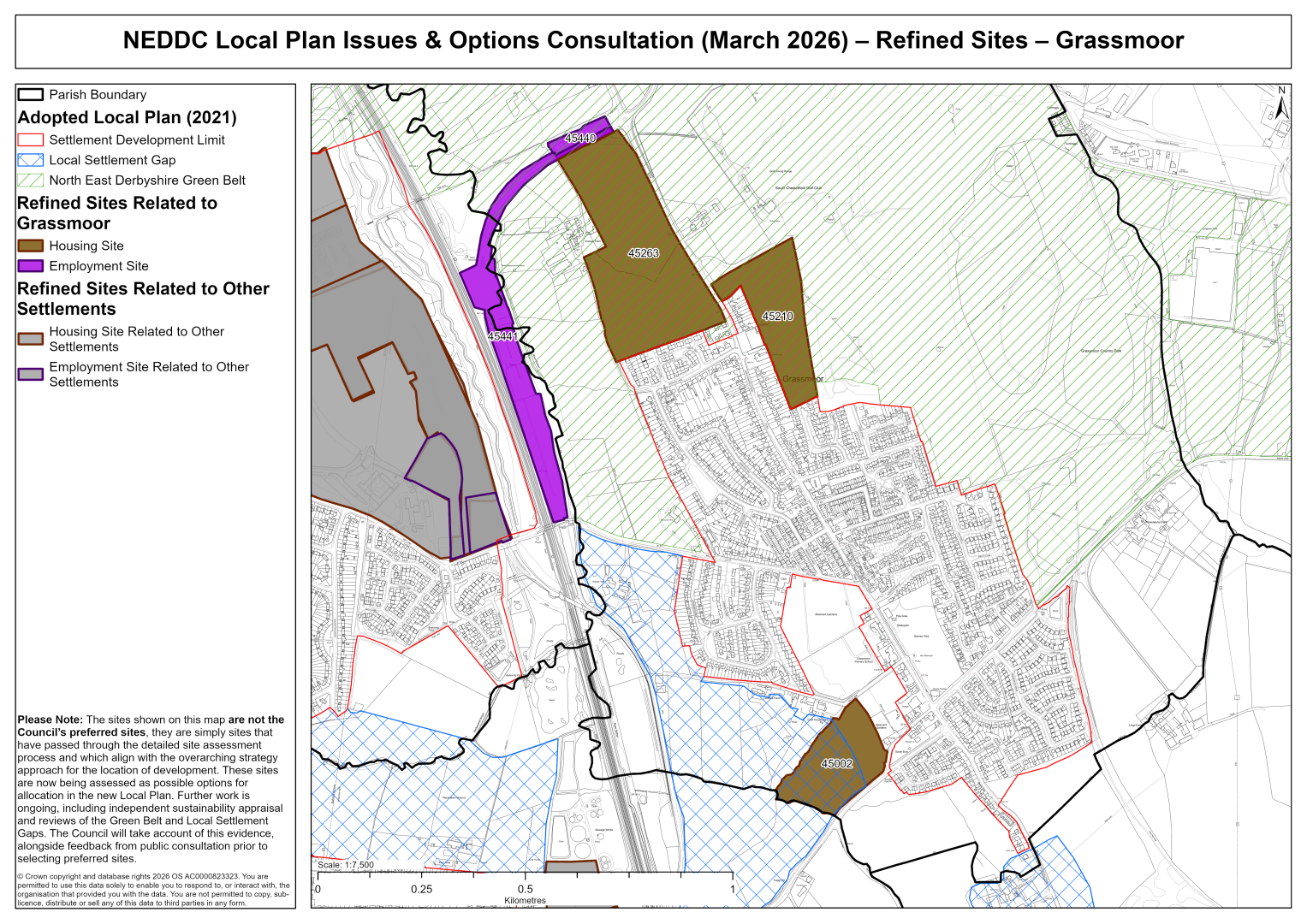
45002 – Land to the south of Gill Lane adjacent to Hagg Hill, Grassmoor
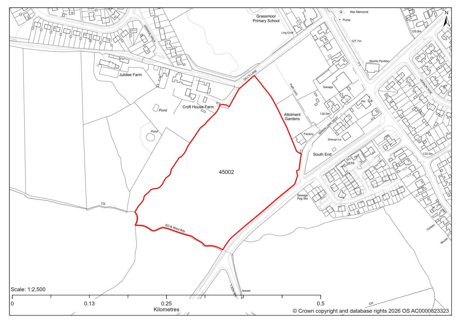
45002 – Land to the south of Gill Lane adjacent to Hagg Hill, Grassmoor
- This site may be able to support approximately 140 dwellings, based on prevailing neighbouring densities, and a 20% density uplift for the most sustainable settlements. Mitigation measures have not been applied to this site capacity yet and may result in an altered total.
- Two thirds of the site is designated as a Local Settlement Gap in the current 2014-2034 Local Plan. An updated Local Settlement Gap Review will inform whether this designation is still appropriate for this site.
- Landscape assessment has classified as moderate level impacts and any allocation should ideally be confined to the northern third of the site where it would form a more natural settlement boundary especially if supported by an appropriate landscaped boundary treatment.
- The ecology assessments find a low to moderate impact.
- There is some risk of surface water flooding on the site.
- A Public Right of Way crosses the site in the far south.
- The site is located within coal authority development high risk area.
If this site were to be taken forward as an allocation, mitigation measures for the above constraints will need to be considered and any Local Plan policy text should include the requirement to address and mitigate the constraints listed above.
45210 – Land off North Wingfield Road, Grassmoor
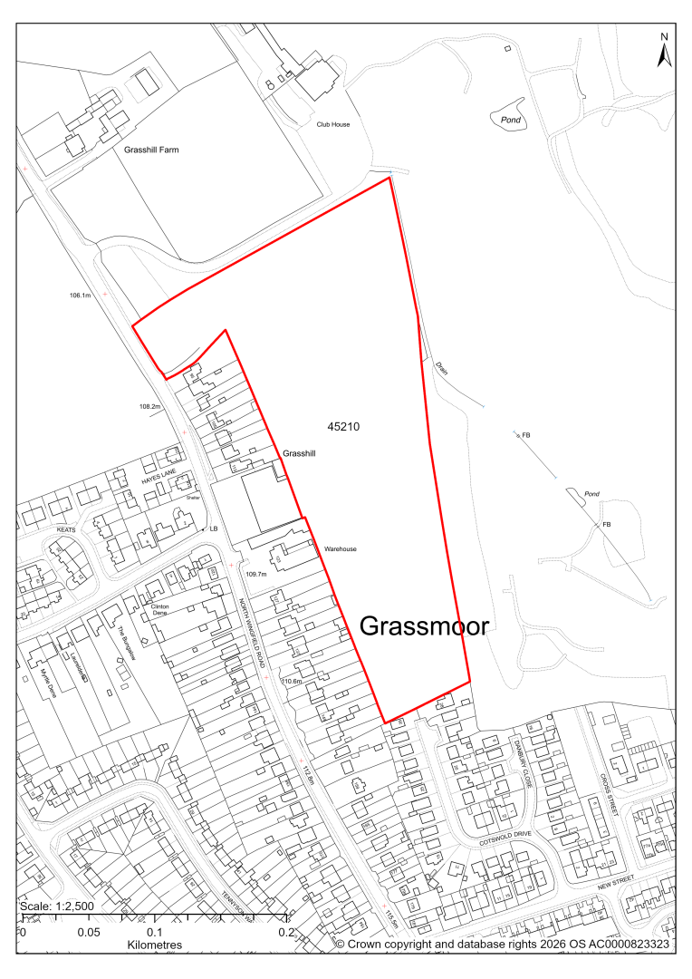
45210 – Land off North Wingfield Road, Grassmoor
- This site may be able to support approximately 110 dwellings, based on prevailing neighbouring densities, and a 20% density uplift for the most sustainable settlements. Mitigation measures have not been applied to this site capacity yet and may result in an altered total.
- The site is located within the Green Belt and will be assessed through a new Green Belt Review to identify the extent to which the site meets Green Belt purposes a, b & d (related to checking unrestricted sprawl, preventing neighbouring towns merging and preserving the setting and special character of historic towns). The review will identify whether the site is Grey Belt and will inform decisions over whether, or not, Green Belt boundaries should be amended to account for development needs – as required by the National Planning Policy Framework (2024).
- For information, the 2016/17 Green Belt Review showed that this site (which aligns with GB land parcel : GRA/GB/004) performed moderately against Green Belt purposes a & b and weaker against purpose d. Please note: the new Green Belt Review will follow the detailed methodology set out in recent National Planning Practice Guidance, which differs to the approach taken in the 2016/17 review, in terms of assessment criteria and what can be considered to be a town). For this reason, the land parcel results may differ.
- There is some risk of surface water flooding on the site.
- The site is located within coal authority development high risk area.
If this site were to be taken forward as an allocation, mitigation measures for the above constraints will need to be considered and any Local Plan policy text should include the requirement to address and mitigate the constraints listed above.
45263 – Land at Avenue Farm, Grassmoor
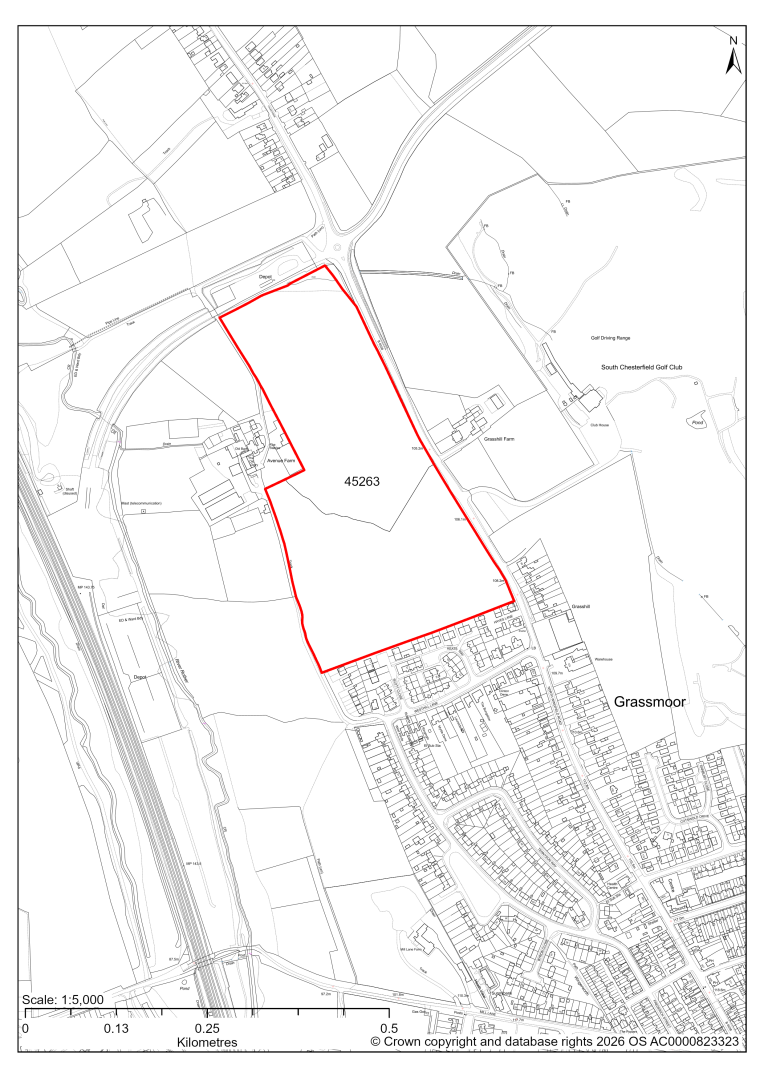
45263 – Land at Avenue Farm, Grassmoor
- This site may be able to support approximately 190 dwellings, based on prevailing neighbouring densities, and a 20% density uplift for the most sustainable settlements. Mitigation measures have not been applied to this site capacity yet and may result in an altered total.
- The site is located within the Green Belt and will be assessed through a new Green Belt Review to identify the extent to which the site meets Green Belt purposes a, b & d (related to checking unrestricted sprawl, preventing neighbouring towns merging and preserving the setting and special character of historic towns). The review will identify whether the site is Grey Belt and will inform decisions over whether, or not, Green Belt boundaries should be amended to account for development needs – as required by the National Planning Policy Framework (2024).
- For information, the 2016/17 Green Belt Review showed that this site (which lies within GB land parcel: GRA/GB/002) performed strongly against Green Belt purpose a & b and weaker against purpose d. Please note: the new Green Belt Review will follow the detailed methodology set out in recent National Planning Practice Guidance, which differs to the approach taken in the 2016/17 review, in terms of assessment criteria and what can be considered to be a town). For this reason, the land parcel results may differ.
- Development on the site may have a moderate landscape impact. Adverse effects associated with urban expansion along the B6038 could be mitigated by considering a reduced allocation to the south of the site.
- Archaeological assessment classifies the site as having archaeological/historic environment issues, but might be suitable for allocation with appropriate site specific policy.
- Desktop ecology advice for the entire site finds a medium impact level of development upon biodiversity. A site visit will be needed in the spring to update the advice.
- There is some risk of surface water flooding on the site.
- The site is located within coal authority development high risk area.
If this site were to be taken forward as an allocation, mitigation measures for the above constraints will need to be considered and any Local Plan policy text should include the requirement to address and mitigate the constraints listed above.
45440 – Former Coal Yard, Grassmoor (Zone A)
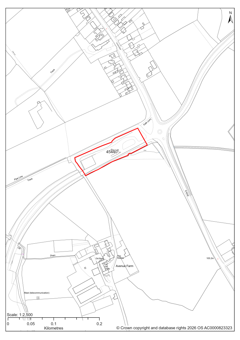
45440 – Former Coal Yard, Grassmoor (Zone A)
This site has detailed planning permission, and the development is now complete. We are intending to include sites which have been built out within our completions totals.
45441 – Former Coal Yard, Grassmoor (Zones B-D)
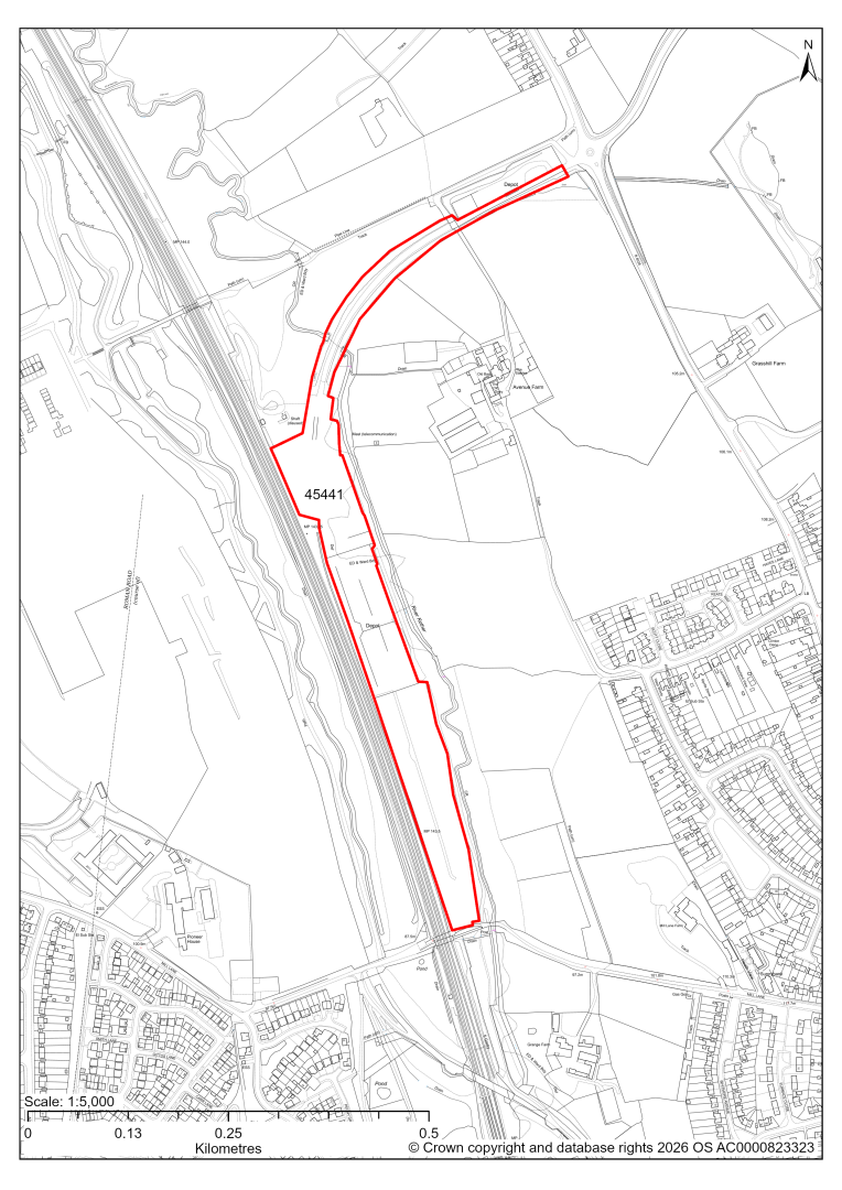
45441 – Former Coal Yard, Grassmoor (Zones B-D)
- This site comprises approximately 4.9 hectares of land situated to the east of the Midland Main Railway Line. The site was first used as railway sidings and then for coal storage and processing solid fuels. The coal yard use ceased around 2009, but the hard standing areas are still intact. The site could support employment development.
- The site was granted outline permission (with all matters reserved apart from access) for the provision of B1 offices, B2 workshops and B8 storage including parking, and reserved matters were approved for individual zones in pursuant to the outline permission. Subsequently a detailed planning application for a storage unit with external storage on Zone C of the site was granted permission. A further proposal for a new build depot on Zones B2 and B3 of the site is currently pending determination by the council.
- We are intending to allocate sites with planning permission, if the development is not yet completed.
Holmewood
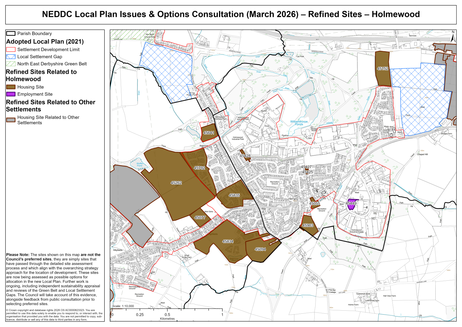
45055 – Holmewood Miners Welfare, 25 Heath Road, Holmewood, Chesterfield
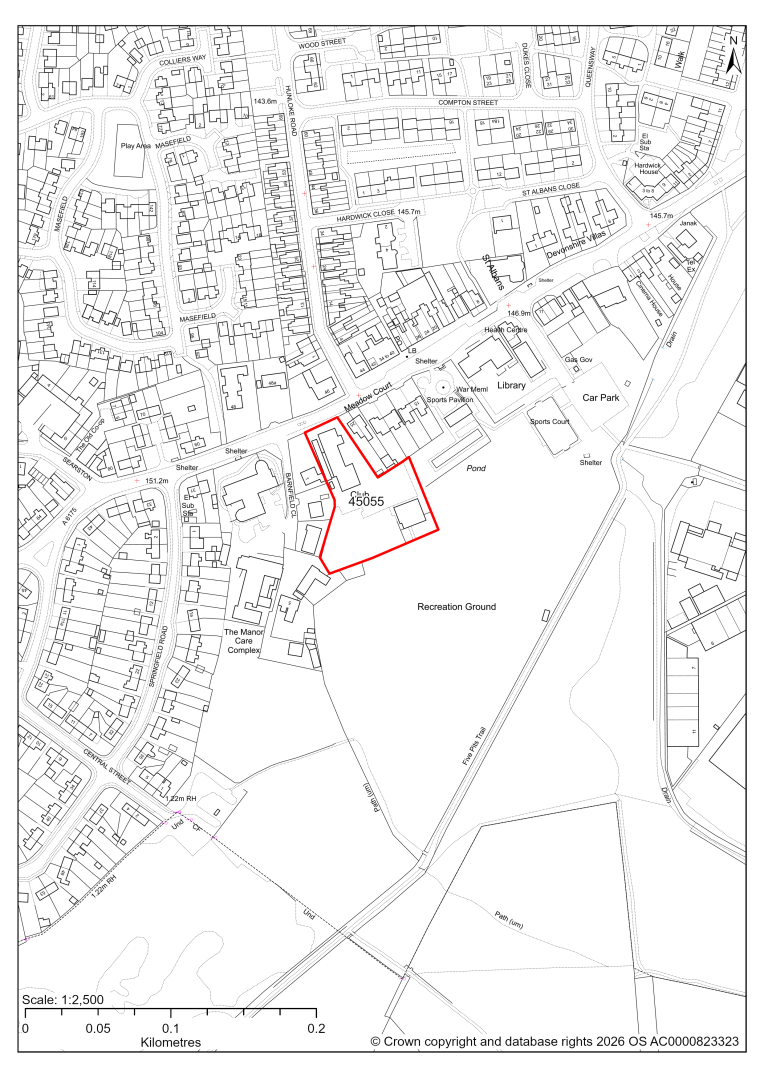
45055 – Holmewood Miners Welfare, 25 Heath Road, Holmewood, Chesterfield
- This site may be able to support approximately 17 dwellings, based on prevailing neighbouring densities, and a 20% density uplift for the most sustainable settlements. Mitigation measures have not been applied to this site capacity yet and may result in an altered total.
- The site currently contains a vacant miners welfare. Redevelopment for residential development would result in the loss of this social infrastructure. Further assessment is needed to establish whether these facilities are no longer viable, needed or valued.
- There is some risk of surface water flooding on the site.
If this site were to be taken forward as an allocation, mitigation measures for the above constraints will need to be considered and any Local Plan policy text should include the requirement to address and mitigate the constraints listed above.
45077 – Land Behind 289 to 339 Williamthorpe Road, Holmewood
45077 – Land behind 289 to 339 Williamthorpe Road, Holmewood
- This site may be able to support approximately 100 dwellings, based on prevailing neighbouring densities, and a 20% density uplift for the most sustainable settlements. Mitigation measures have not been applied to this site capacity yet and may result in an altered total.
- Highway access may need to be confirmed further.
- There is some risk of surface water flooding on the site.
- The site is located within a coal authority development high risk area.
If this site were to be taken forward as an allocation, mitigation measures for the above constraints will need to be considered and any Local Plan policy text should include the requirement to address and mitigate the constraints listed above.
45094 – Land to Side and Rear of Goodacres Tibshelf Road, Holmewood
45094 – Land to side and rear of Goodacres Tibshelf Road, Homewood
- This site may be able to support approximately 130 dwellings, based on prevailing neighbouring densities, and a 20% density uplift for the most sustainable settlements. Mitigation measures have not been applied to this site capacity yet and may result in an altered total.
- Development on the site may have a moderate landscape impact. Development within the single field to the north may be more easily accommodated but the larger site would need substantive landscaping to help address the potential impact on immediate and wider views.
- There is some risk of surface water flooding on the site.
If this site were to be taken forward as an allocation, mitigation measures for the above constraints will need to be considered and any Local Plan policy text should include the requirement to address and mitigate the constraints listed above.
45152 – Land to West of Slack Lane, Holmewood
45152 – Land to west of Slack Lane, Holmewood
- This site may be able to support approximately 150 dwellings, based on prevailing neighbouring densities, and a 20% density uplift for the most sustainable settlements. Mitigation measures have not been applied to this site capacity yet and may result in an altered total.
- The site is visually prominent, development on the site could have a moderate landscape impact.
- The site is at risk of some surface water flooding.
- Part of the site is located within the National Grid emerging preferred corridor for a new overhead electricity line. This brings a level of uncertainty on timely delivery of the residential development, which will need to be considered when exploring the housing trajectory.
- The site is located within a coal authority development high risk area.
If this site were to be taken forward as an allocation, mitigation measures for the above constraints will need to be considered and any Local Plan policy text should include the requirement to address and mitigate the constraints listed above.
45262 – Land to the West of Feld Lane, Holmewood
45262 – Land to the West of Feld Lane, Holmewood
- This site may be able to support approximately 670 dwellings, based on prevailing neighbouring densities, and a 20% density uplift for the most sustainable settlements. Mitigation measures have not been applied to this site capacity yet and may result in an altered total.
- Development on the site would have a strategic level landscape impact. It has no significant strength of character or landscape constraints, other than by virtue of its scale, which may be mitigated. However, it will need to be assessed strategically with site 45236 to the west because collectively these would create more significant landscape character and visual impacts through the coalescence of North Wingfield and Holmewood.
- Ecology advice finds a moderate impact level of development upon biodiversity.
- Highway access may need to be confirmed further.
- There is some risk of surface water flooding on the site.
- A Public Rights of Way crosses the site.
- There are pylons and overhead power lines crossing the site.
- The site is located within a coal authority development high risk area.
If this site were to be taken forward as an allocation, mitigation measures for the above constraints will need to be considered and any Local Plan policy text should include the requirement to address and mitigate the constraints listed above.
45425 – Car Park at Hunloke Road, Holmewood
45425 – Car Park at Hunloke Road, Holmewood
- This site may be able to support approximately 7 dwellings, based on prevailing neighbouring densities, and a 20% density uplift for the most sustainable settlements. Mitigation measures have not been applied to this site capacity yet and may result in an altered total.
- The minor site could be combined with neighbouring site 45427.
- Highway assessment is yet to take place.
- There is some risk of surface water flooding on the site.
If this site were to be taken forward as an allocation, mitigation measures for the above constraints will need to be considered and any Local Plan policy text should include the requirement to address and mitigate the constraints listed above.
45427 – Land at Hunloke Road, Holmewood
45427 – Land at Hunloke Road, Holmewood
- This site may be able to support approximately 6 dwellings, based on prevailing neighbouring densities, and a 20% density uplift for the most sustainable settlements. Mitigation measures have not been applied to this site capacity yet and may result in an altered total.
- The minor site could be combined with neighbouring site 45425.
- Ecology assessment is yet to take place.
- Highway assessment is yet to take place.
- There is some risk of surface water flooding on the site.
If this site were to be taken forward as an allocation, mitigation measures for the above constraints will need to be considered and any Local Plan policy text should include the requirement to address and mitigate the constraints listed above.
45428 – Garage Site at Shakespeare Street, Holmewood
45428 – Garage Site at Shakespeare Street, Holmewood
- This site may be able to support approximately 13 dwellings, based on prevailing neighbouring densities, and a 20% density uplift for the most sustainable settlements. Mitigation measures have not been applied to this site capacity yet and may result in an altered total.
- The site is at risk of some surface water flooding.
If this site were to be taken forward as an allocation, mitigation measures for the above constraints will need to be considered and any Local Plan policy text should include the requirement to address and mitigate the constraints listed above.
45641 – Land South of 205 Chesterfield Road, Holmewood (2014-2034 LP Allocation HO3)
45641 – Land South of 205 Chesterfield Road, Holmewood (2014-2034 LP allocation HO3)
- This site may be able to support approximately 50 dwellings, based on prevailing neighbouring densities, and a 20% density uplift for the most sustainable settlements. Mitigation measures have not been applied to this site capacity yet and may result in an altered total.
- The site is a housing allocation in the current 2014-2034 Local Plan.
- A planning application for 33 apartments for older people, a church hall and associated development is currently pending determination by the Council.
- There is some risk of surface water flooding on the site.
- The site is located within a coal authority development high risk area.
If this site were to be taken forward as an allocation, mitigation measures for the above constraints will need to be considered and any Local Plan policy text should include the requirement to address and mitigate the constraints listed above.
45792 and 45835 - Land on the West Side of Chesterfield Road, Holmewood
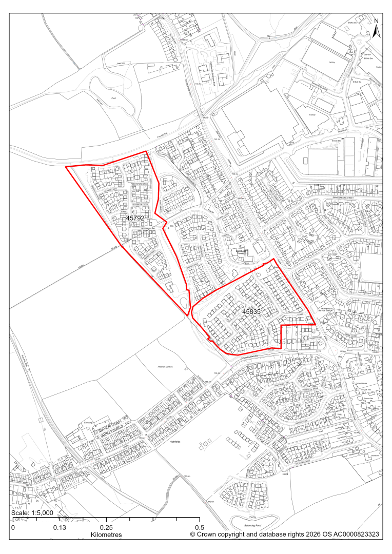
45792 and 45835 – Land on the West Side Of Chesterfield Road, Holmewood
This is a large site with planning permission for housing development. Some phases have not been completed yet. These include:
45792: The site has detailed planning permission for housing development and is under construction. At our 2025 monitoring, another 15 dwellings were yet to be completed. 2026 monitoring information is not available yet. We are intending to allocate any major sites with planning permission, if there is a remaining capacity of 10 or more dwellings that have not been completed yet.
45835: The site has detailed planning permission for housing development and is under construction. At our 2025 monitoring, another 48 dwellings were yet to be completed. 2026 monitoring information is not available yet. We are intending to allocate any major sites with planning permission, if there is a remaining capacity of 10 or more dwellings that have not been completed yet.
45834 – Windy Ridge, Tibshelf Road, Holmewood
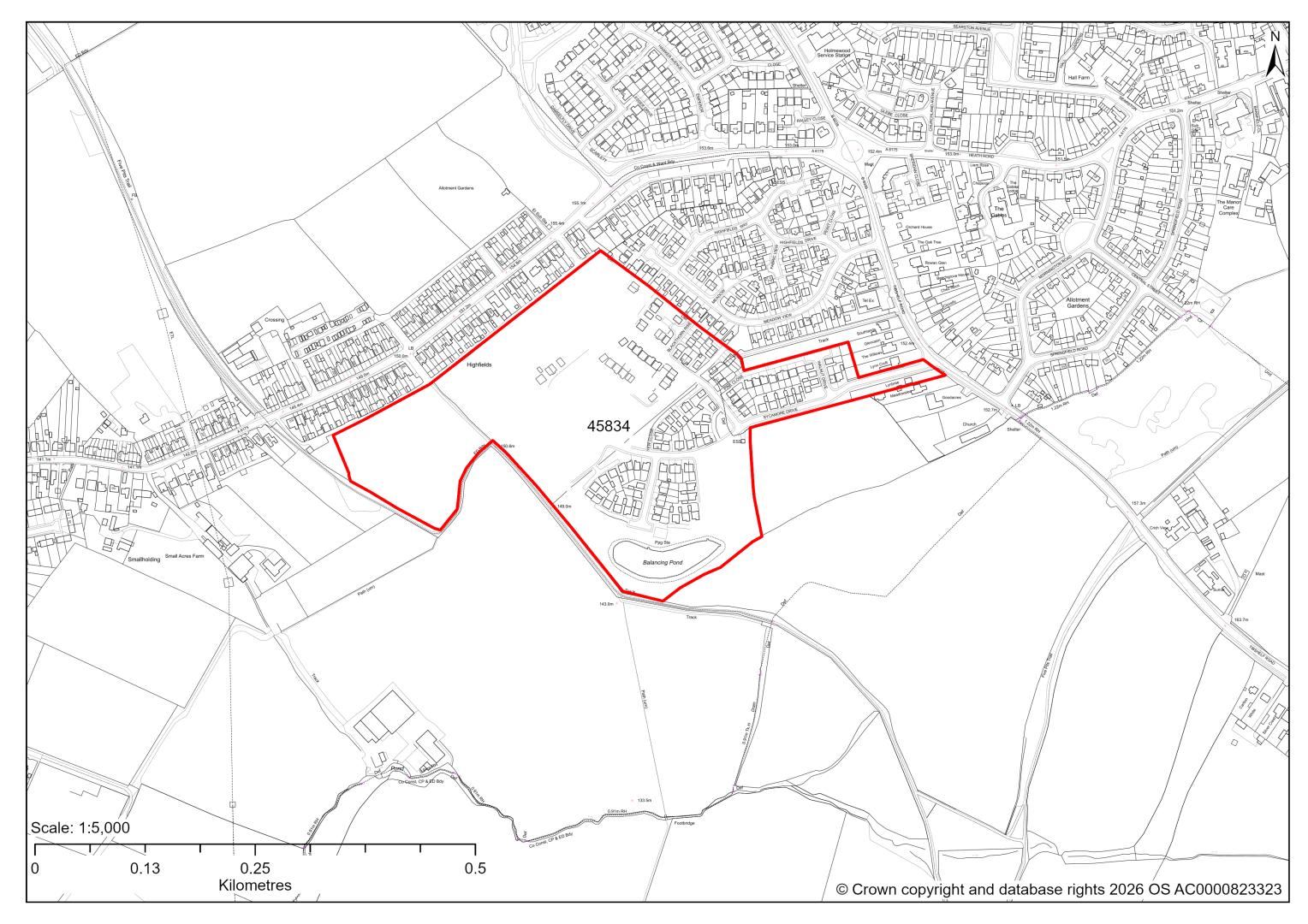
45834 – Windy Ridge, Tibshelf Road, Holmewood
The site has planning permission for 247 dwellings. At our 2025 monitoring, 192 dwellings were yet to be completed. 2026 monitoring information is not available yet. We are intending to allocate any major sites with planning permission, if there is a remaining capacity of 10 or more dwellings that have not been completed yet.
45903 – Land East of Central Street, Holmewood
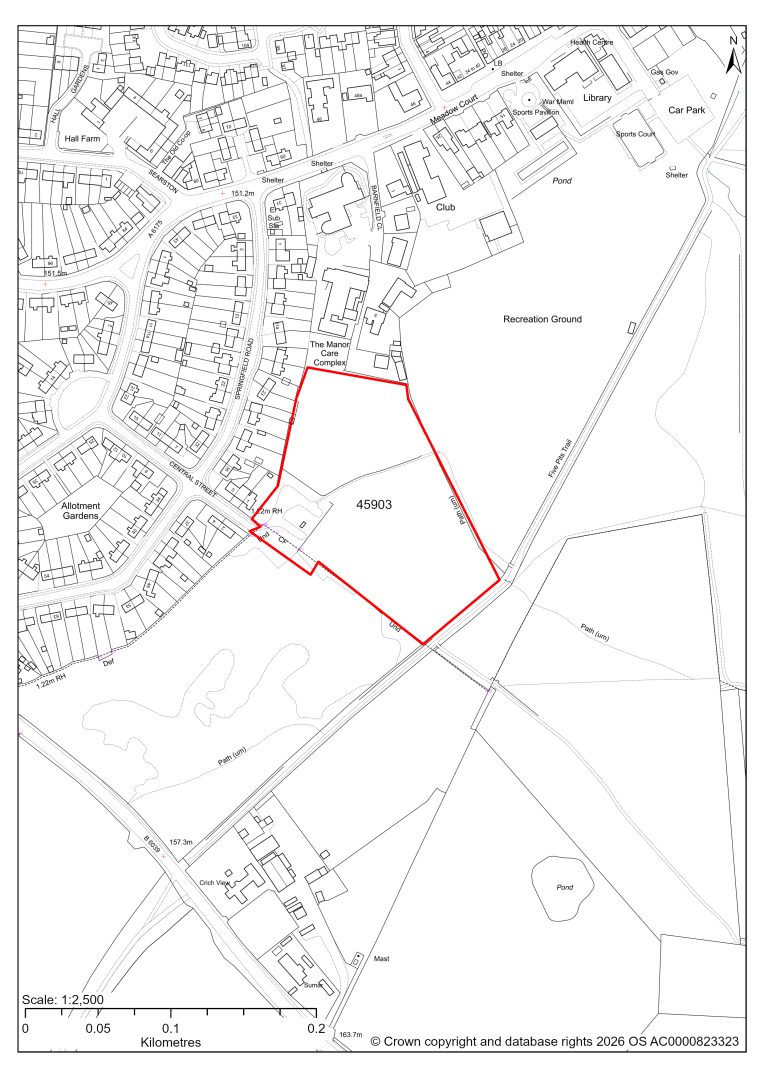
45903 – Land East of Central Street, Holmewood
- This site may be able to support approximately 60 dwellings, based on prevailing neighbouring densities, and a 20% density uplift for the most sustainable settlements. Mitigation measures have not been applied to this site capacity yet and may result in an altered total.
- A planning application for residential development is currently pending determination by the Council.
- Desktop ecology advice finds a medium impact level of development upon biodiversity. A site visit will be needed.
- There is some risk of surface water flooding on the site.
- The site is located within a coal authority development high risk area.
If this site were to be taken forward as an allocation, mitigation measures for the above constraints will need to be considered and any Local Plan policy text should include the requirement to address and mitigate the constraints listed above.
45192 – Land to north of Mansfield Road, Doe Lea (within Heath & Holmewood Parish)
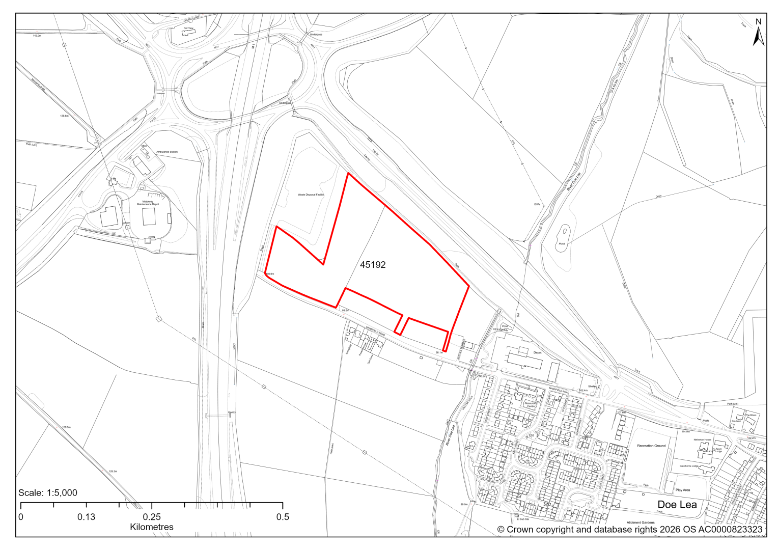
45192 – Land to north of Mansfield Road, Doe Lea (within Heath & Holmewood Parish)
- This site comprises approximately 5.5 hectares of land situated to the east of the M1 motorway and south of the A617 Mansfield Road to the west of Doe Lea (which falls within neighbouring Bolsover District). To the north west between the site and the M1 motorway is an area of land currently used for B8 open storage. The site could support employment development.
- Landscape assessment has identified the site is relatively well screened in the local landscape due to its low lying levels relative to the M1 motorway and the A617 Mansfield Road together with extensive boundary vegetation. Development of the site may have a moderate level landscape impact.
- The site lies within the setting of several heritage assets. Development on the site could introduce significant visual effects into the wider landscape which forms part of the ‘heritage triangle’ between Hardwick Hall, Bolsover Castle and Sutton Scarsdale Hall.
- Creating access from Mansfield Road to the south of the site would require removal of a hedge and part of a grassed area. Consideration would need be given to extending the footway along Mansfield Road to the site.
- Approximately 22% of the site is covered by Flood Zones 2 and 3, which would need to be excluded from the developable area. There is some risk of surface water flooding on the site which would need to be addressed.
- Part of the site is located within a coal authority development high risk area.
If this site were taken forward as an employment allocation, mitigation measures for the above constraints will need to be considered and any Local plan policy text should include the requirement to address and mitigate the constraints listed above.
45449 - Land off Hardwick View Road, Holmewood Industrial Estate
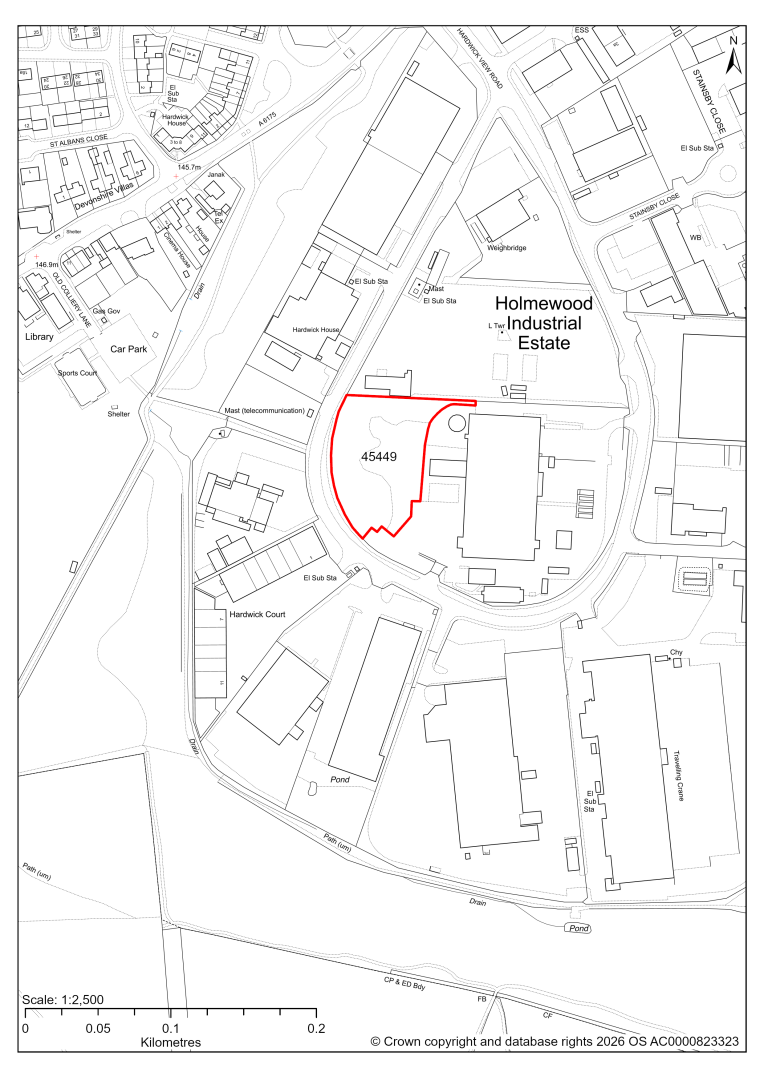
45449 – Land off Hardwick View Road, Holmewood Industrial Estate
- This site comprises approximately 0.55 hectares of land within the Holmewood Industrial Estate which is designated as a Principal Employment Area in the current 2014-2034 Local Plan. The site could support employment development.
- Desktop ecology assessment identifies the site supports woodland scrub and grassland, and development may have medium level impact upon biodiversity.
- Creating an access off Hardwick View Road would require removal of a grass verge and pavement, and the difference in land levels between the site and the highway would need to be considered.
- Approximately 5% of the site comprising a linear section along its northern boundary is at risk of surface water flooding.
If this site were taken forward as an employment allocation, mitigation measures for the above constraints will need to be considered and any Local plan policy text should include the requirement to address and mitigate the constraints listed above.
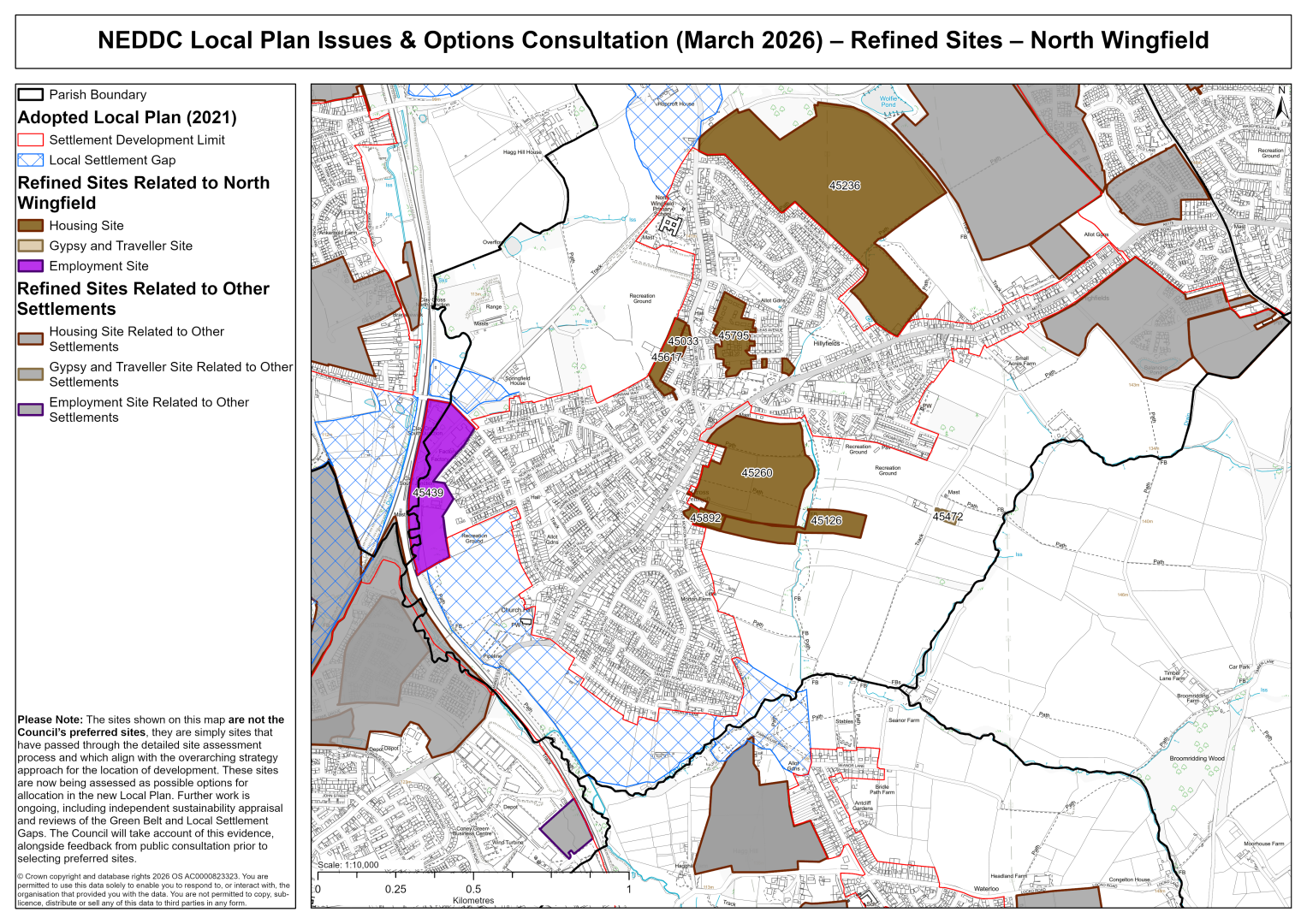
North Wingfield
45033 – North Wingfield Working Mens Club, 36 Chesterfield Road, North Wingfield, Chesterfield
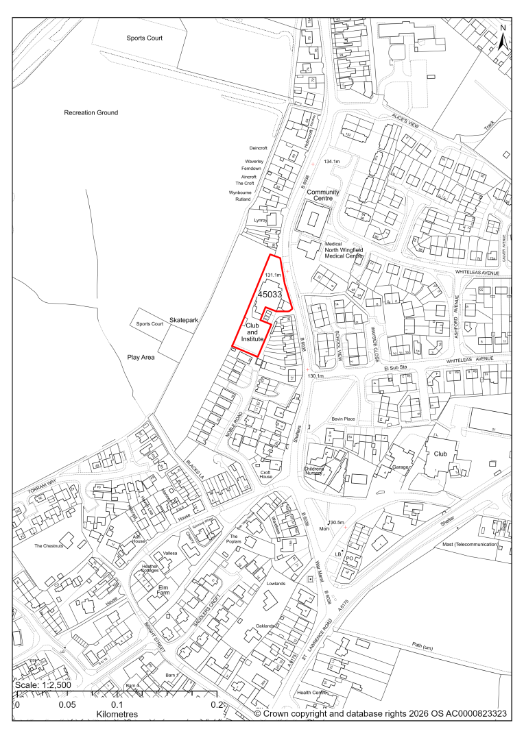
45033 – North Wingfield Working Mens Club, 36 Chesterfield Road, North Wingfield, Chesterfield
- This site may be able to support approximately 10 dwellings, based on prevailing neighbouring densities, and a 20% density uplift for the most sustainable settlements. Mitigation measures have not been applied to this site capacity yet and may result in an altered total.
- The site currently contains vacant working mens club. Redevelopment for residential development would result in the loss of this social infrastructure. Further assessment is needed to establish whether this facility is no longer viable, needed or valued.
- The site is at risk of some surface water flooding.
If this site were to be taken forward as an allocation, mitigation measures for the above constraints will need to be considered and any Local Plan policy text should include the requirement to address and mitigate the constraints listed above.
45126 – Land off 5 Little Morton Road, North Wingfield
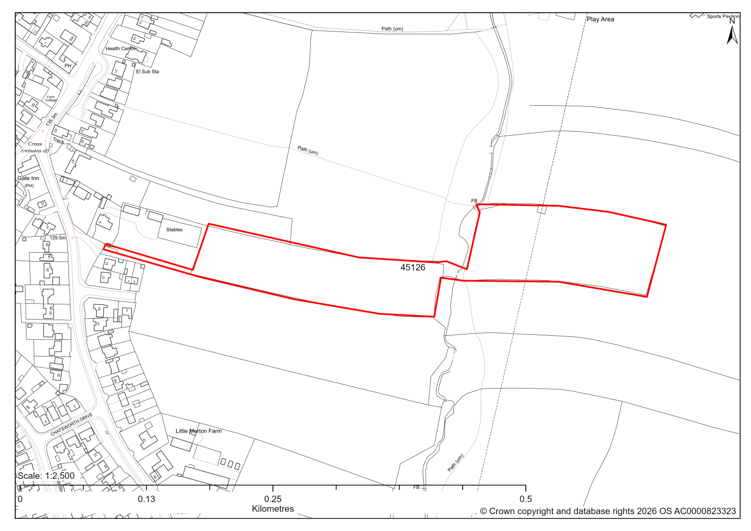
45126 – Land off 5 Little Morton Road, North Wingfield
- This site may be able to support approximately 50 dwellings, based on prevailing neighbouring densities, and a 20% density uplift for the most sustainable settlements. Mitigation measures have not been applied to this site capacity yet and may result in an altered total.
- Development on the site would have a moderate landscape impact. In isolation development would poorly relate to the existing settlement pattern. Landscape assessment recommends that development beyond the PRoW to the east should be resisted as this breaks what would be perceived as a strong visual edge screened by existing vegetation.
- Archaeological assessment classifies the site as having archaeological / historic environment issues, but might be suitable for allocation with appropriate site specific policy. This is due to the remnant fossilised strip. Although the site only represents approximately 6% of the total area of the ancient strip fields and is not the best preserved, the site forms an urban projections into this moderately important piece of historic landscape which may be harmful if developed as a standalone development.
- The site can be combined with site 45260 to the north.
- Ecology advice finds a medium impact level of development upon biodiversity on part of the site. The impact could be avoided or significantly minimised by development being restricted to the western part of the site only.
- Highway access may need to be confirmed further, including the impact on the Registered Common Land at the site access.
- Less than 1% of the site is located within flood risk zones 2 and 3.
- A Public Right of Way crosses the site.
- The site is located within a coal authority development high risk area.
If this site were to be taken forward as an allocation, mitigation measures for the above constraints will need to be considered and any Local Plan policy text should include the requirement to address and mitigate the constraints listed above.
45892 – 5 Little Morton Road, North Wingfield
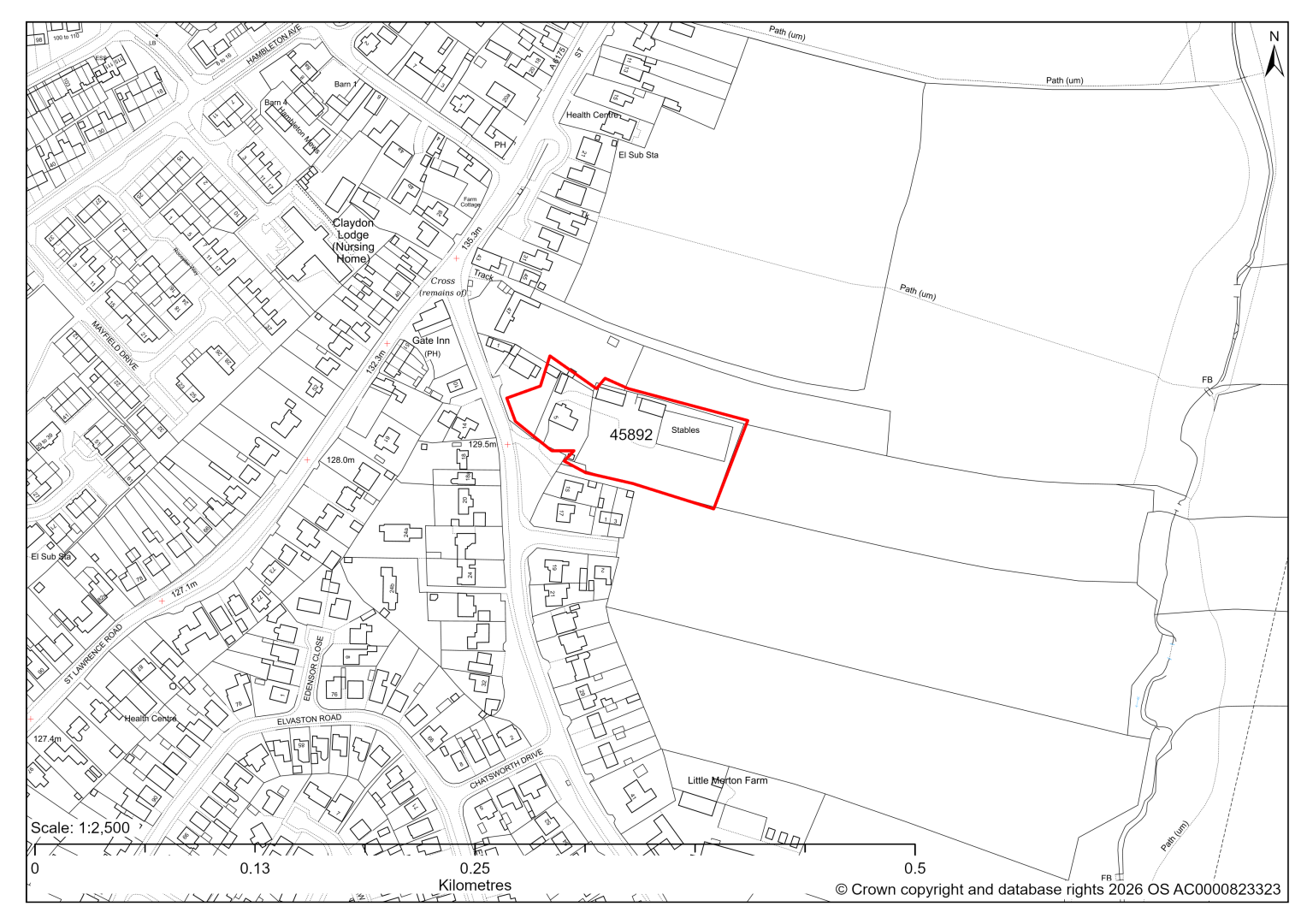
45892 – 5 Little Morton Road, North Wingfield
- This site may be able to support approximately 15 dwellings, based on prevailing neighbouring densities, and a 20% density uplift for the most sustainable settlements. Mitigation measures have not been applied to this site capacity yet and may result in an altered total.
- The site is in close proximity to a Grade II Listed Building.
- Highway access may need to be confirmed further, including the impact on the Registered Common Land at the site access.
- The site is located within a coal authority development high risk area.
If this site were to be taken forward as an allocation, mitigation measures for the above constraints will need to be considered and any Local Plan policy text should include the requirement to address and mitigate the constraints listed above
45260 – Land to the East Side of St Lawrence Road, North Wingfield
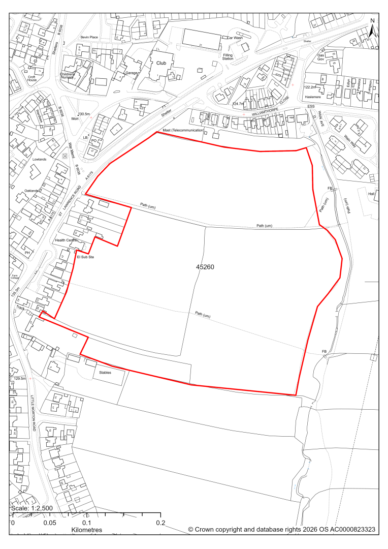
45260 – Land to the East side of St Lawrence Road, North Wingfield
- This site may be able to support approximately 210 dwellings, based on prevailing neighbouring densities, and a 20% density uplift for the most sustainable settlements. Mitigation measures have not been applied to this site capacity yet and may result in an altered total.
- Development on the site would have a strategic level landscape impact, together with the sites to the south (the most southern site 45139 has since been found as unsuitable). The site has some strength of character, but views are screened locally by the tree belt in the east.
- The site is in close proximity to several Listed Buildings.
- Highway access may need to be confirmed further.
- Public Rights of Way cross the site.
- The site is located within a coal authority development high risk area.
If this site were to be taken forward as an allocation, mitigation measures for the above constraints will need to be considered and any Local Plan policy text should include the requirement to address and mitigate the constraints listed above.
45236 – Land North of Williamthorpe Road and East of Chesterfield Road, North Wingfield, Derbyshire
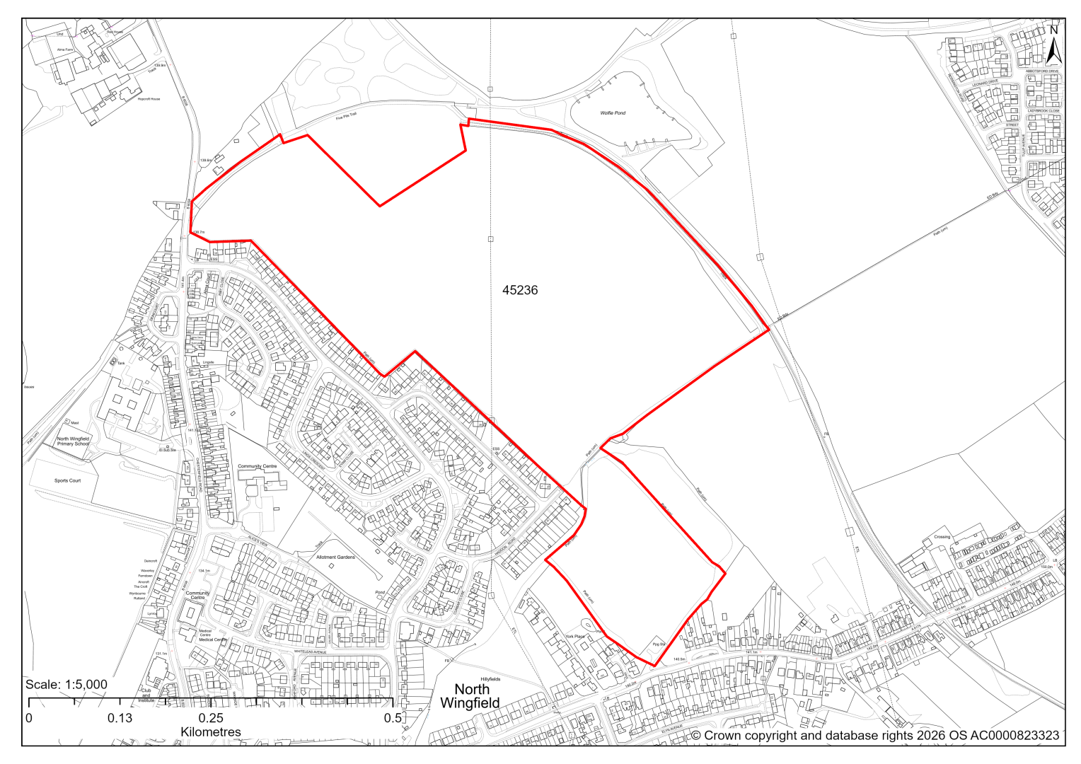
45236 – Land North of Williamthorpe Road and East of Chesterfield Road, North Wingfield, Derbyshire
- This site may be able to support approximately 520 dwellings, based on prevailing neighbouring densities, and a 20% density uplift for the most sustainable settlements. Mitigation measures have not been applied to this site capacity yet and may result in an altered total.
- Development on the site would have a strategic level landscape impact. It has no significant strength of character or landscape constraints, other than by virtue of its scale, which may be mitigated. However, it will need to be assessed strategically with site 45262 to the east because collectively these would create more significant landscape character and visual impacts through the coalescence of North Wingfield and Holmewood.
- Development on the site would have a moderate level of impact on biodiversity.
- Approximately 3.5% of the site is located within flood risk zones 2 and 3. There are also areas at risk of surface water flooding on the site.
- Public Rights of Way cross the site, as well as a proposed cycle route and greenway.
- The site is located within a coal authority development high risk area.
If this site were to be taken forward as an allocation, mitigation measures for the above constraints will need to be considered and any Local Plan policy text should include the requirement to address and mitigate the constraints listed above.
45439 – Land off Station Road, North Wingfield
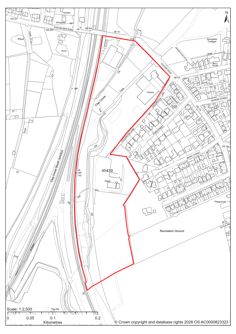
45439 – Land off Station Road, North Wingfield
- This site comprises approximately 4.8 hectares of land situated off Station Road / Occupation Lane, North Wingfield which is identified as a General Employment Area within the current 2014-2034 Local Plan. Parts of the site are already in employment use but there is undeveloped land which could support additional employment uses.
- Landscape assessment has classified as moderate level impact.
- The site includes a former workshop/engine shed associated with its previous use as railway sidings, which should be retained as part of any development.
- The Derbyshire Historic Environment Record provides evidence of archaeological remains in the form of pre-historic flints previously found on the site.
- Desktop ecology assessment finds a high impact upon biodiversity as development is likely to have significant impact on woodland, river and grassland habitats. Site visits will further examine ecological impacts.
- The River Rother flows south to north through the site. Approximately 34% of the site falls within Flood Zones 2 and 3, which will need to be excluded from the developable area.
- There is some risk of surface water flooding on the site.
If this site were taken forward as an employment allocation, mitigation measures for the above constraints will need to be considered and any Local Plan policy text should include the requirement to address and mitigate the constraints listed above.
45472 – Land East of Dark Lane, North Wingfield
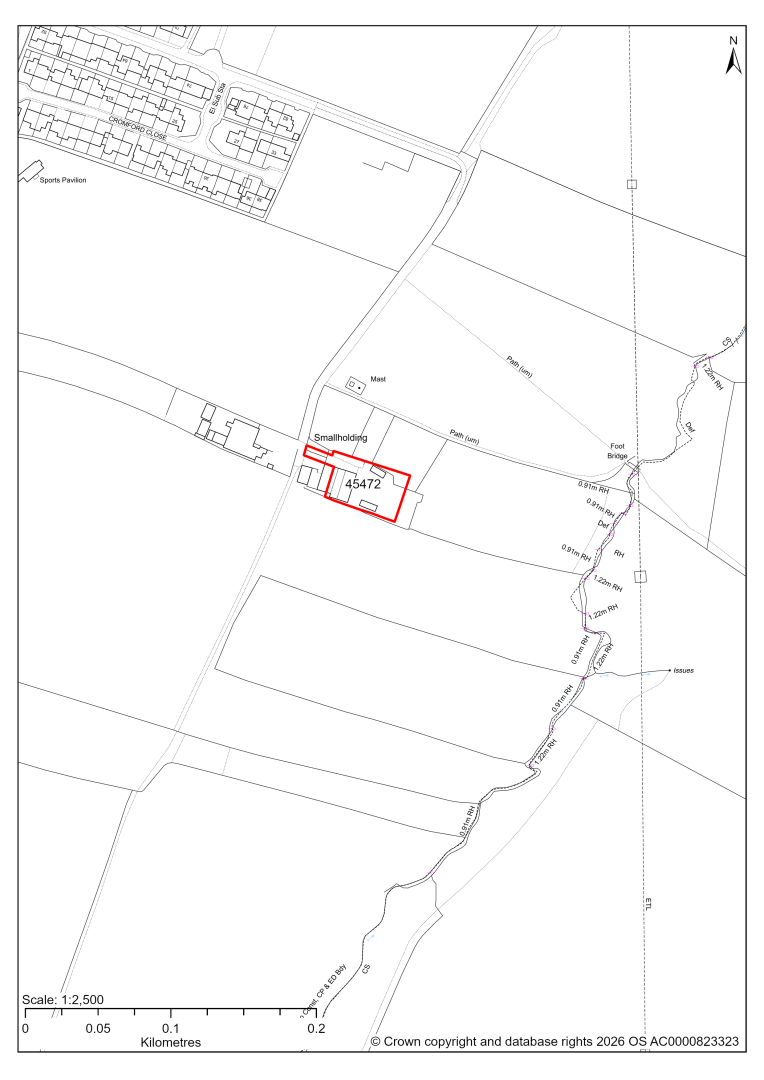
45472 – Land east of Dark Lane, North Wingfield
- The site would form an extension to the existing traveller site at Dark Lane, North Wingfield and is expected to deliver 3 traveller pitches.
- The site is allocated for 3 pitches in the current Local Plan (2014-2034).
If this site were to be taken forward as an allocation, mitigation measures for the above constraints will need to be considered and any Local Plan policy text should include the requirement to address and mitigate the constraints listed above.
45617 – North Wingfield Primary School, Draycott Road
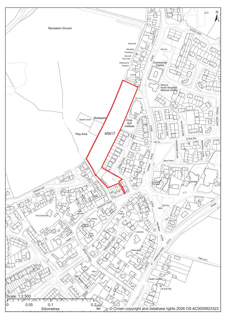
45617 – North Wingfield Primary School, Draycott Road, North Wingfield
The site and a wider area has recently been granted planning permission for 64 dwellings. 2026 monitoring information is not available yet, but it will be likely that the site boundary of this site will be adjusted to align with the planning permission. We are intending to allocate any major sites with planning permission, if there is a remaining capacity of 10 or more dwellings that have not been completed yet.
45795 – Whiteleas Avenue, North Wingfield
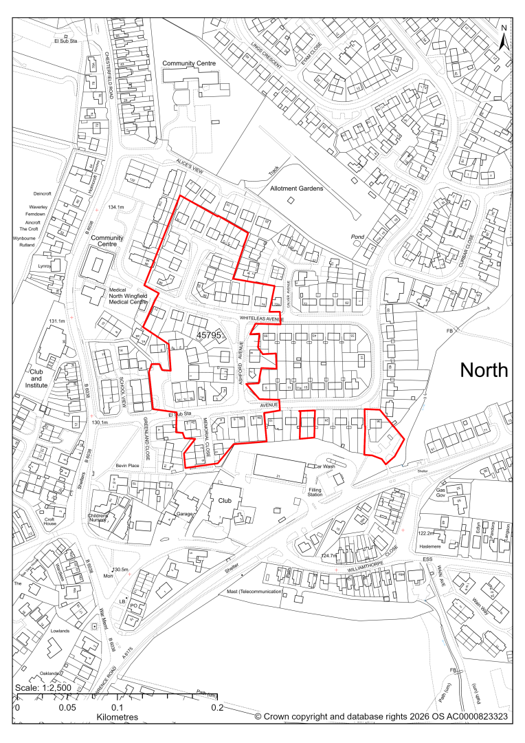
45795 – Whiteleas Avenue, North Wingfield
The site has planning permission for 70 dwellings. At our 2025 monitoring, 22 dwellings were yet to be completed. 2026 monitoring information is not available yet. We are intending to allocate any major sites with planning permission, if there is a remaining capacity of 10 or more dwellings that have not been completed yet.
Pilsley (Pilsley Cluster)
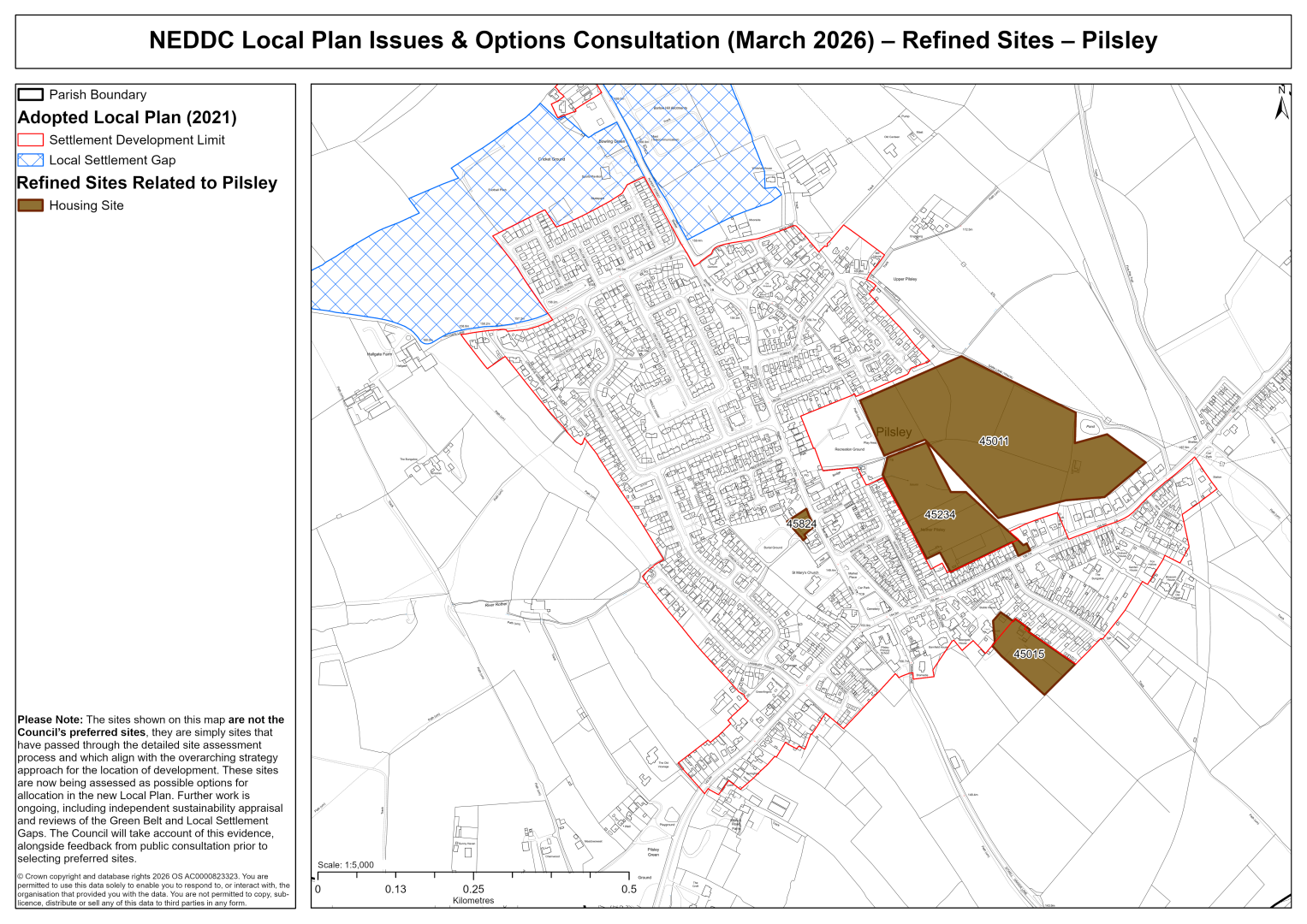
45011 – Land to the rear of Station Road, Pilsley
45011 – Land to the rear of Station Road, Pilsley
- This site may be able to support approximately 130 dwellings, based on prevailing neighbouring densities, and a 20% density uplift for the most sustainable settlements. Mitigation measures have not been applied to this site capacity yet and may result in an altered total.
- Development on the site may have a moderate landscape impact. Mitigation might include setting back from the Five Pits Trail, which could be enhanced as a key Green Infrastructure asset, and the retention of mature landscape features.
- The ecology assessments find a moderate impact.
- Highway access may need to be confirmed further.
- Under 1% of the site is located within flood risk zone 2. There are also some areas at risk of surface water flooding.
- Natural England’s provisional agricultural land classification of the southern area is grade 3.
- A small area of the site is located within coal authority development high risk area.
If this site were to be taken forward as an allocation, mitigation measures for the above constraints will need to be considered and any Local Plan policy text should include the requirement to address and mitigate the constraints listed above.
45234 – Land to the rear of 2 to 68 Queen Street and 19 to 57 Station Road, Pilsley
45234 – Land to the rear of 2 to 68 Queen Street and 19 to 57 Station Road, Pilsley
- This site may be able to support approximately 90 dwellings, based on prevailing neighbouring densities, and a 20% density uplift for the most sustainable settlements. Mitigation measures have not been applied to this site capacity yet and may result in an altered total.
- Planning permission was granted for 77 dwellings in 2014; this permission subsequently expired, raising uncertainty about availability which will need to be clarified further.
- Highway access may need to be confirmed further.
- Under 1% of the site is located within flood risk zone 2. There are also some areas at risk of surface water flooding.
- Natural England’s provisional agricultural land classification of the southern area is grade 3.
- The site is located within coal authority development high risk area.
If this site were to be taken forward as an allocation, mitigation measures for the above constraints will need to be considered and any Local Plan policy text should include the requirement to address and mitigate the constraints listed above.
45015 – Land to rear of Manor House, Manor Close, Pilsley
45015 – Land to rear of Manor House, Manor Close, Pilsley
- This site may be able to support approximately 25 dwellings, based on prevailing neighbouring densities, and a 20% density uplift for the most sustainable settlements. Mitigation measures have not been applied to this site capacity yet and may result in an altered total.
- Highway access may need to be confirmed further.
- The site is located within coal authority development high risk area.
If this site were to be taken forward as an allocation, mitigation measures for the above constraints will need to be considered and any Local Plan policy text should include the requirement to address and mitigate the constraints listed above.
45824 – Commercial Inn, Bridge Street, Pilsley
45824 – Commercial Inn, Bridge Street, Pilsley
The site has planning permission for 10 apartments. At our 2025 monitoring, construction had yet to commence. 2026 monitoring information is not available yet. We are intending to allocate any major sites with planning permission, if there is a remaining capacity of 10 or more dwellings that have not been completed yet.
Lower Pilsley (Pilsley Cluster)
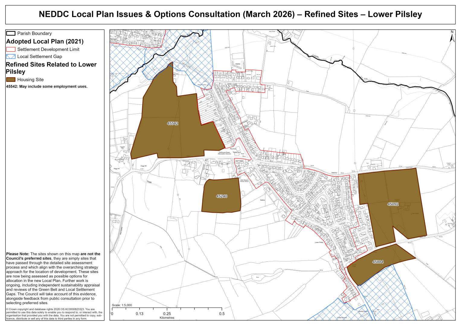
45092 – Tregarthyan House Green Lane and land adjacent to Mulberry Walk, Lower Pilsley
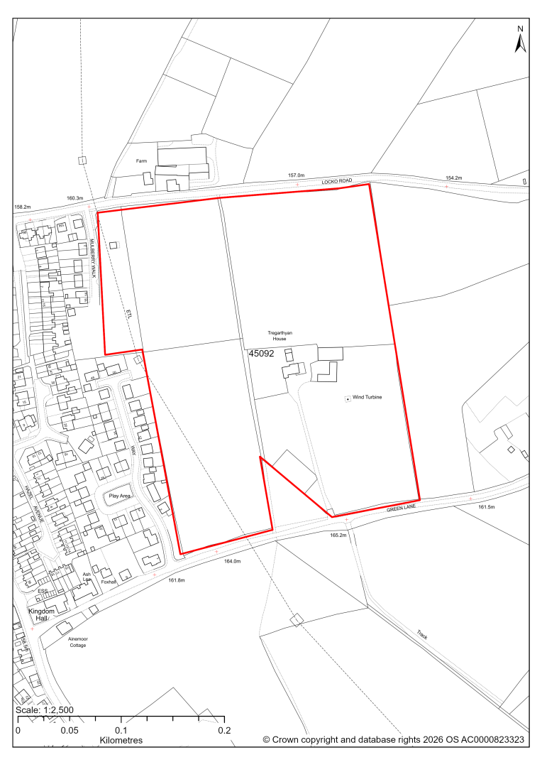
45092 – Tregarthyan House Green Lane and land adjacent to Mulberry Walk, Lower Pilsley
- This site may be able to support approximately 240 dwellings, based on prevailing neighbouring densities, and a 20% density uplift for the most sustainable settlements. Mitigation measures have not been applied to this site capacity yet and may result in an altered total.
- Development on the site may have a moderate landscape impact.M itigation might include substantive landscaping as part of a Green Infrastructure network to help address the visual impacts locally.
- There are some areas at risk of surface water flooding.
- There are some pylons and overhead power lines crossing the site in the west.
- A Public Right of Way crosses the site.
- Natural England’s provisional agricultural land classification of the southern area is grade 3.
- The site is located within coal authority development high risk area.
If this site were to be taken forward as an allocation, mitigation measures for the above constraints will need to be considered and any Local Plan policy text should include the requirement to address and mitigate the constraints listed above.
45240 – Land behind Upper Croft, Lower Pilsley
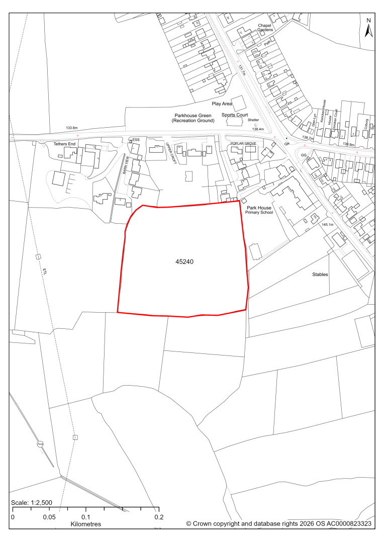
45240 – Land behind Upper Croft, Lower Pilsley
- This site may be able to support approximately 60 dwellings, based on prevailing neighbouring densities, and a 20% density uplift for the most sustainable settlements. Mitigation measures have not been applied to this site capacity yet and may result in an altered total.
- Development on the site may have a moderate landscape impact. Mitigation might include appropriate stand offs to existing mature vegetation with additional complimentary landscaping.
- There is a TPO tree along the northern edge of the site.
- Highway access may need to be confirmed further.
- The site is located within coal authority development high risk area.
If this site were to be taken forward as an allocation, mitigation measures for the above constraints will need to be considered and any Local Plan policy text should include the requirement to address and mitigate the constraints listed above.
45542 – Land at Lower Pilsley
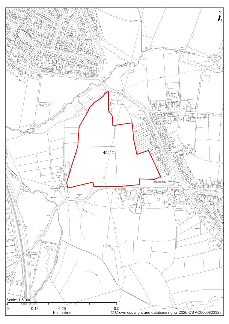
45542 – Land at Lower Pilsley
- This site may be able to support approximately 110 dwellings, based on prevailing neighbouring densities, and a 20% density uplift for the most sustainable settlements. Mitigation measures have not been applied to this site capacity yet and may result in an altered total.
- Development on the site may have a strategic landscape impact, in particular at the western side of the site. The landscape assessment advises that the site plays a key role in maintaining the spatial separation of Lower Pilsley and North Wingfield, and recommends considering a smaller allocation. However, the Local Settlement Gap designation in the current Local Plan (2014 – 2034) only covers a very small part in the northern part of the site. An updated Local Settlement Gap Review will inform whether this designation is still appropriate in its current form.
- There are some areas at risk of surface water flooding.
- A Public Right of Way crosses the site.
- There are some pylons and overhead power lines crossing the site in the west.
- The site is located within coal authority development high risk area.
If this site were to be taken forward as an allocation, mitigation measures for the above constraints will need to be considered and any Local Plan policy text should include the requirement to address and mitigate the constraints listed above.
45884 – Land East of Rupert Street and South of Green Lane, Lower Pilsley
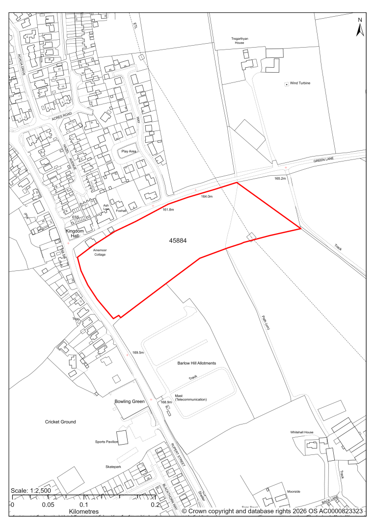
45884 – Land East of Rupert Street and South of Green Lane, Lower Pilsley
- This site may be able to support approximately 80 dwellings, based on prevailing neighbouring densities, and a 20% density uplift for the most sustainable settlements. Mitigation measures have not been applied to this site capacity yet and may result in an altered total.
- The site has been included due to planning permission having expired for 54 dwellings in the last five years, in line with national planning policy guidance on site identification. Availability will need to be confirmed with the landowner.
- Current landscape assessment has found a major landscape impact, however the 2016 application had been able to address and mitigate landscape concerns.
- Highway access may need to be confirmed further.
- There are some areas at risk of surface water flooding.
- There are some pylons and overhead power lines crossing the site in the west.
- A Public Right of Way crosses the site.
If this site were to be taken forward as an allocation, mitigation measures for the above constraints will need to be considered and any Local Plan policy text should include the requirement to address and mitigate the constraints listed above.
Renishaw
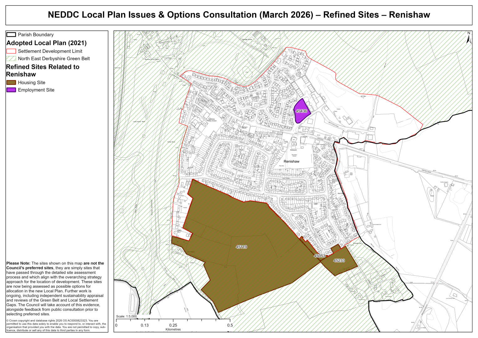
45053 – Land off Garden Avenue, Renishaw
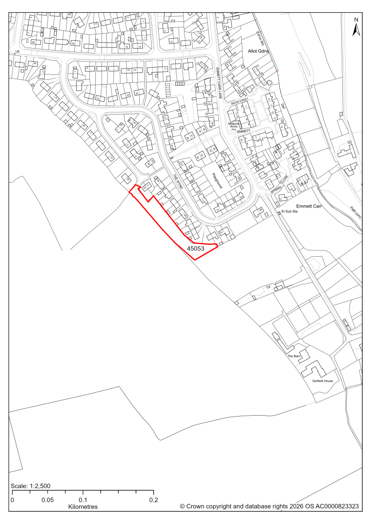
45053 – Land off Garden Avenue, Renishaw
- This site may be able to support approximately 11 dwellings, based on prevailing neighbouring densities, and a 20% density uplift for the most sustainable settlements. Mitigation measures have not been applied to this site capacity yet and may result in an altered total.
- The site is located within the Green Belt and will be assessed through a new Green Belt Review to identify the extent to which the site meets Green Belt purposes a, b & d (related to checking unrestricted sprawl, preventing neighbouring towns merging and preserving the setting and special character of historic towns). The review will identify whether the site is Grey Belt and will inform decisions over whether, or not, Green Belt boundaries should be amended to account for development needs – as required by the National Planning Policy Framework (2024).
- For information, the 2016/17 Green Belt Review showed that this site (which lies within a small part of GB land parcel: REN/GB/004B) performed strongly against Green Belt purpose a, moderately against purpose b and weaker against purpose d. Please note: the new Green Belt Review will follow the detailed methodology set out in recent National Planning Practice Guidance, which differs to the approach taken in the 2016/17 review, in terms of assessment criteria and what can be considered to be a town). For this reason, the land parcel results may differ.
- The site is located within coal authority development high risk area.
If this site were to be taken forward as an allocation, mitigation measures for the above constraints will need to be considered and any Local Plan policy text should include the requirement to address and mitigate the constraints listed above.
45119 – Land off Hague Lane, Renishaw
45119 – Land off Hague Lane, Renishaw
- This site may be able to support approximately 400 dwellings, based on prevailing neighbouring densities, and a 20% density uplift for the most sustainable settlements. Mitigation measures have not been applied to this site capacity yet and may result in an altered total.
- The site is located within the Green Belt and will be assessed through a new Green Belt Review to identify the extent to which the site meets Green Belt purposes a, b & d (related to checking unrestricted sprawl, preventing neighbouring towns merging and preserving the setting and special character of historic towns). The review will identify whether the site is Grey Belt and will inform decisions over whether, or not, Green Belt boundaries should be amended to account for development needs – as required by the National Planning Policy Framework (2024).
- For information, the 2016/17 Green Belt Review showed that this site (which covers the entirety of GB land parcel REN/GB/004A and half of both parcel REN/GB/005 and REN/GB/004B) performed moderately against purposes a & b and weakly against purpose d. Please note: the new Green Belt Review will follow the detailed methodology set out in recent National Planning Practice Guidance, which differs to the approach taken in the 2016/17 review, in terms of assessment criteria and what can be considered to be a town). For this reason, the land parcel results may differ.
- Development on the site may have a moderate landscape impact. Mitigation might include setting back from Hague Lane and the local ridgeline supported by appropriate landscape treatments.
- Archaeological assessment classifies the site as having archaeological/historic environment issues, but might be suitable for allocation with appropriate site specific policy.
- Highway access may need to be confirmed further.
- Natural England’s provisional agricultural land classification of the southern area is grade 3.
- The site is located within coal authority development high risk area.
If this site were to be taken forward as an allocation, mitigation measures for the above constraints will need to be considered and any Local Plan policy text should include the requirement to address and mitigate the constraints listed above.
45233 – Land at The Wynd, Renishaw
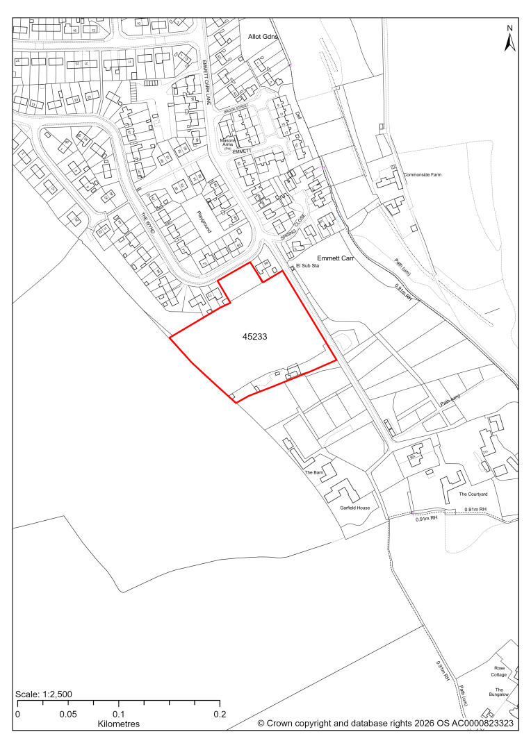
45233 – Land at The Wynd, Renishaw
- This site may be able to support approximately 50 dwellings, based on prevailing neighbouring densities, and a 20% density uplift for the most sustainable settlements. Mitigation measures have not been applied to this site capacity yet and may result in an altered total.
- The site is located within the Green Belt and will be assessed through a new Green Belt Review to identify the extent to which the site meets Green Belt purposes a, b & d (related to checking unrestricted sprawl, preventing neighbouring towns merging and preserving the setting and special character of historic towns). The review will identify whether the site is Grey Belt and will inform decisions over whether, or not, Green Belt boundaries should be amended to account for development needs – as required by the National Planning Policy Framework (2024).
- For information, the 2016/17 Green Belt Review showed that this site (which lies within GB land parcel: REN/GB/002) performed strongly against Green Belt purpose a, moderately against purpose b and weaker against purpose d. Please note: the new Green Belt Review will follow the detailed methodology set out in recent National Planning Practice Guidance, which differs to the approach taken in the 2016/17 review, in terms of assessment criteria and what can be considered to be a town). For this reason, the land parcel results may differ.
- Desktop ecology assessments find a medium impact.
- Possible former landfill sites in the vicinity need further consideration.
- The site is located within coal authority development high risk area.
If this site were to be taken forward as an allocation, mitigation measures for the above constraints will need to be considered and any Local Plan policy text should include the requirement to address and mitigate the constraints listed above.
45436 – Land off Ravenshorn Way, Renishaw
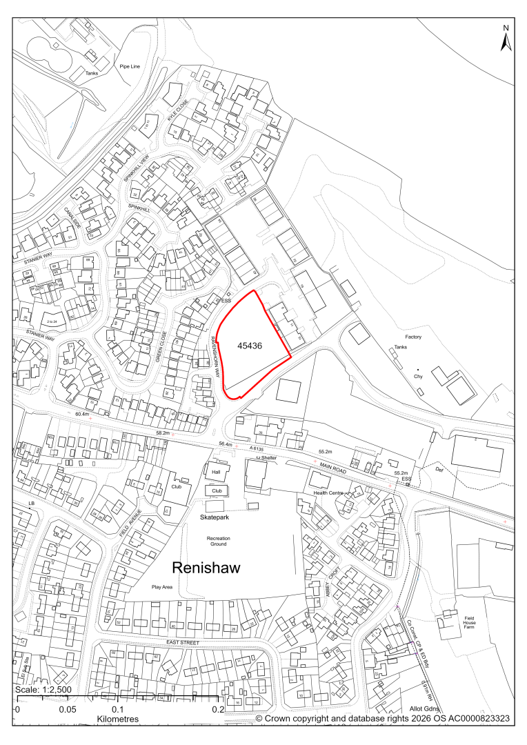
45436 – Land off Ravenshorn Way, Renishaw
- This site comprises approximately 0.47 hectares of land adjacent to existing employment uses within the Renishaw Industrial Estate. The site and the wider area are identified as a Principal Employment Area in the current 2024-2034 Local Plan. The site could support employment development.
- Ecology advice finds a medium impact level of development upon biodiversity as the site supports a mosaic of habitats.
- There are several possible access options to the site from Smithy Brook Road / Ravenshorn Way.
- Approximately 12% of the site along part of its south eastern boundary lies within Flood Zones 2 and 3. There is some risk of surface water flooding on the site, less than 3% of the site.
If this site were taken forward as an employment allocation, mitigation measures for the above constraints will need to be considered and any Local Plan policy text should include the requirement to address and mitigate the constraints listed above.
Mickley (Shirland Cluster)
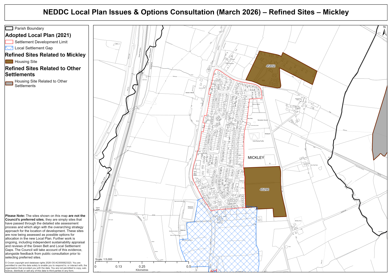
45290 – Land east of Mickley Infant School, Mickley, Stretton
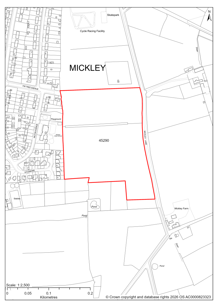
45290 – Land east of Mickley Infant School, Mickley, Stretton
- This site may be able to support approximately 140 dwellings, based on prevailing neighbouring densities, and a 20% density uplift for the most sustainable settlements. Mitigation measures have not been applied to this site capacity yet and may result in an altered total.
- A small area of the site has been safeguarded for education facilities and should be excluded from the development area.
- There are several TPO trees on the eastern boundary.
- There are some areas at risk of surface water flooding.
- The site is located within coal authority development high risk area.
If this site were to be taken forward as an allocation, mitigation measures for the above constraints will need to be considered and any Local Plan policy text should include the requirement to address and mitigate the constraints listed above.
45850 – Ainmoor Grange Caravan And Camping Park, Mickley Lane, Mickley, Stretton
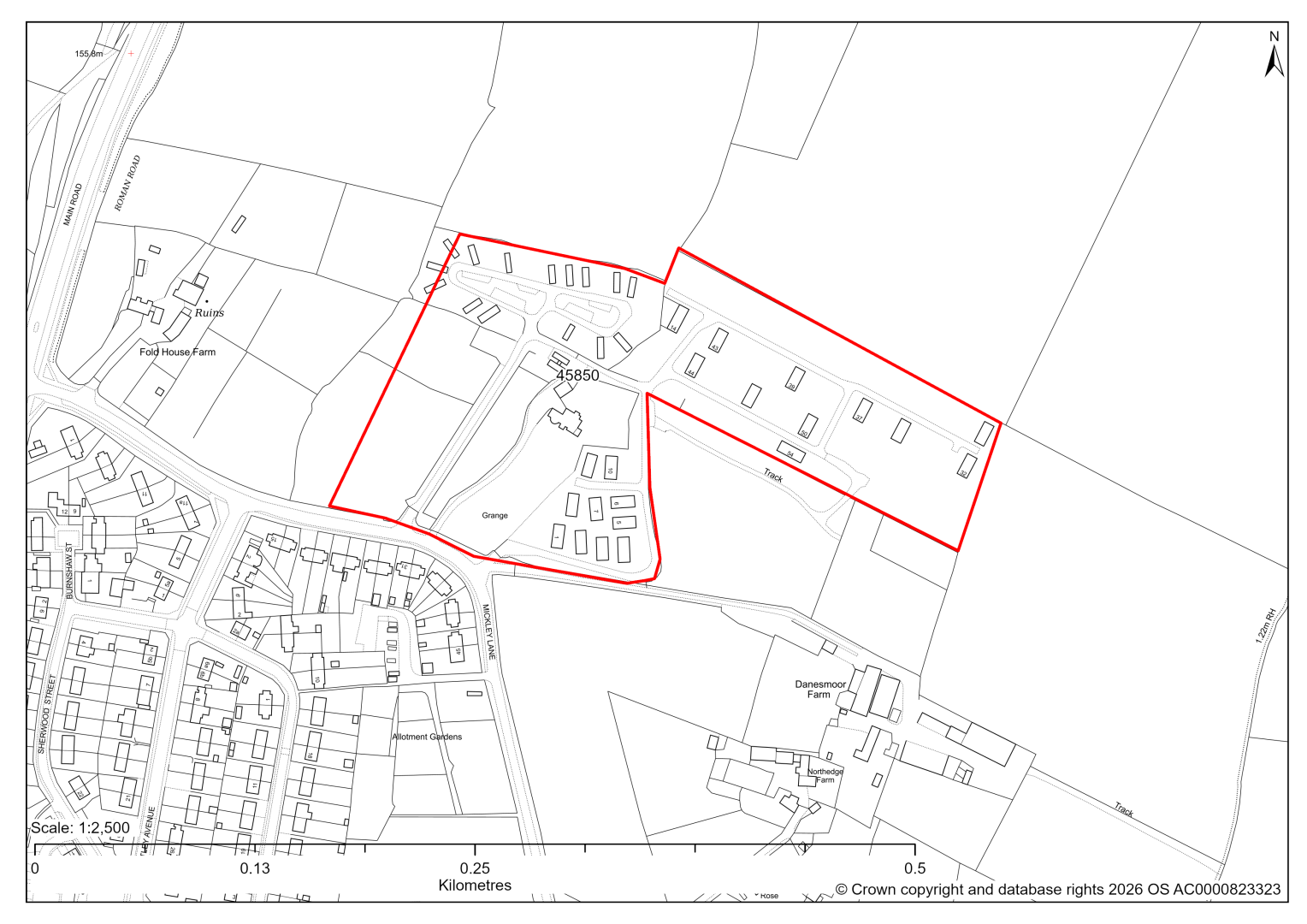
45850 – Ainmoor Grange Caravan And Camping Park, Mickley Lane, Mickley, Stretton
The site has planning permission for 53 residential caravans. At our 2025 monitoring, 31 caravans were yet to be completed. 2026 monitoring information is not available yet. We are intending to allocate any major sites with planning permission, if there is a remaining capacity of 10 or more dwellings that have not been completed yet.
Shirland (Shirland Cluster)
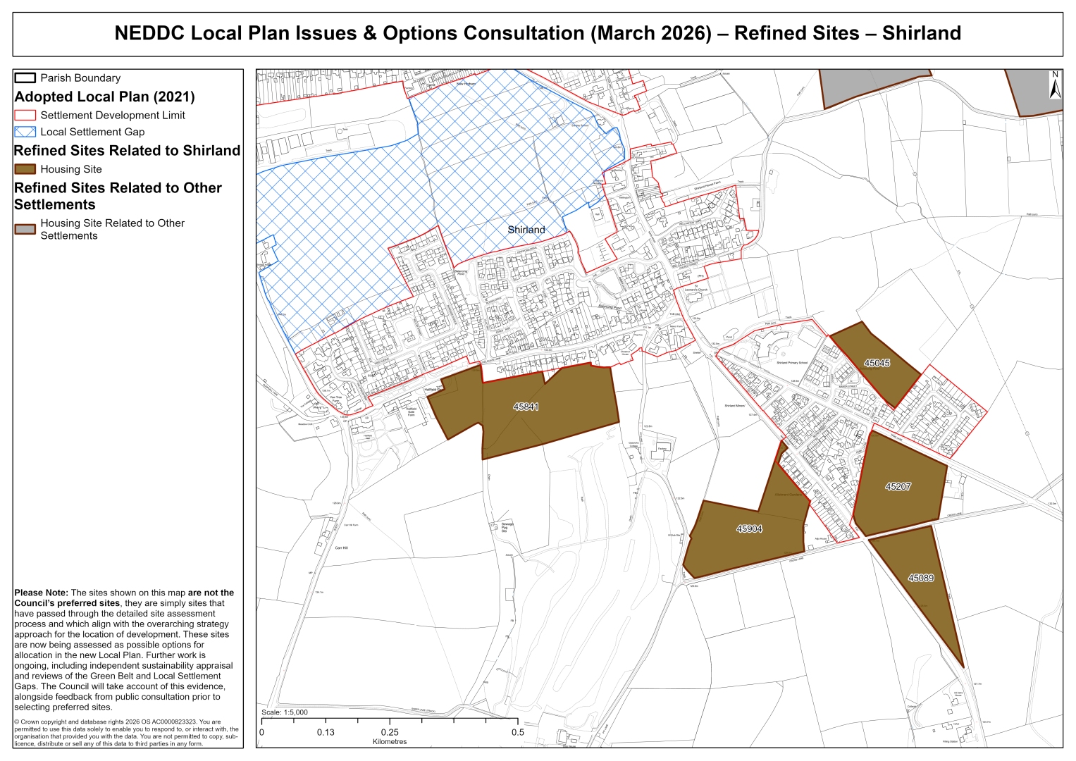
45045 – Land north of Park Lane, Shirland
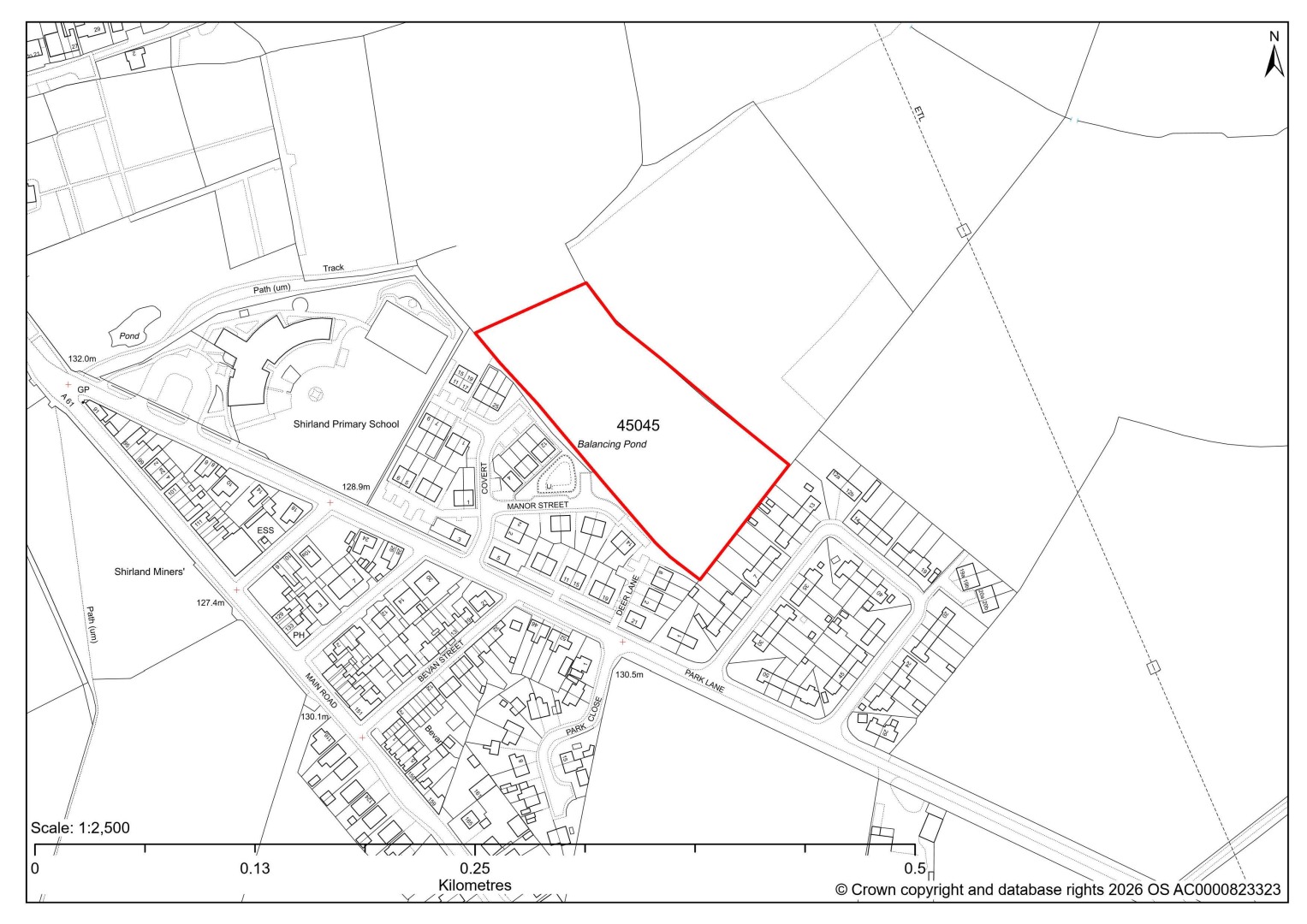
45045 – Land north of Park Lane, Shirland
- This site may be able to support approximately 45 dwellings, based on prevailing neighbouring densities, and a 20% density uplift for the most sustainable settlements. Mitigation measures have not been applied to this site capacity yet and may result in an altered total.
- The site is covered by a ‘Significant Green Gaps’ designation in the Shirland Neighbourhood Plan 2022-34. These designations will be reviewed alongside the current Local Plan’s Local Settlement Gaps in the forthcoming Local Settlement Gaps Review. This will inform the suitability of the potential development allocation sites.
- There are some areas at risk of surface water flooding.
If this site were to be taken forward as an allocation, mitigation measures for the above constraints will need to be considered and any Local Plan policy text should include the requirement to address and mitigate the constraints listed above.
45089 – Land at Cross Lane, Shirland
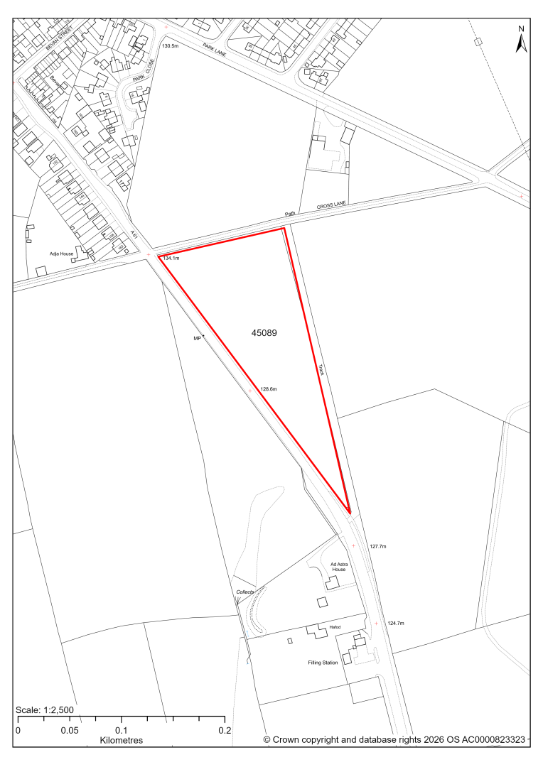
45089 – Land at Cross Lane, Shirland
- This site may be able to support approximately 60 dwellings, based on prevailing neighbouring densities, and a 20% density uplift for the most sustainable settlements. Mitigation measures have not been applied to this site capacity yet and may result in an altered total.
- Development on the site may have a moderate landscape impact. Although no significant landscape constraints, in isolation the site relates poorly to the existing nucleated pattern of development of Shirland and could be perceived as urban sprawl. It needs to be considered strategically with site 45207.
- There are some areas at risk of surface water flooding.
- There are two TPO trees on the northern boundary
- The site is located within coal authority development high risk area.
If this site were to be taken forward as an allocation, mitigation measures for the above constraints will need to be considered and any Local Plan policy text should include the requirement to address and mitigate the constraints listed above.
45207 – Land east of Park Close, Park Lane, Shirland
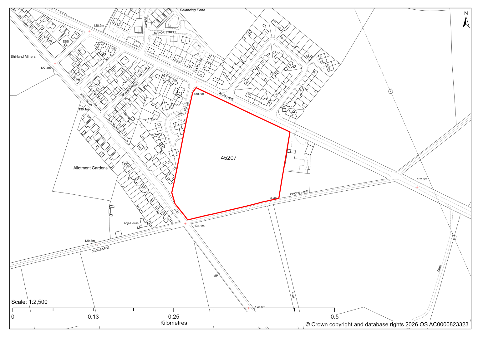
45207 – Land east of Park Close, Park Lane, Shirland
- This site may be able to support approximately 80 dwellings, based on prevailing neighbouring densities, and a 20% density uplift for the most sustainable settlements. Mitigation measures have not been applied to this site capacity yet and may result in an altered total.
- The site is covered by a ‘Significant Green Gaps’ designation in the Shirland Neighbourhood Plan 2022-34. These designations will be reviewed alongside the current Local Plan’s Local Settlement Gaps in the forthcoming Local Settlement Gaps Review. This will inform the suitability of the potential development allocation sites.
- There are some areas at risk of surface water flooding.
- There are a few TPO trees at the southern and eastern boundary
- The site is located within coal authority development high risk area.
If this site were to be taken forward as an allocation, mitigation measures for the above constraints will need to be considered and any Local Plan policy text should include the requirement to address and mitigate the constraints listed above.
45904 – Land West of Main Road and North of Cross Lane, Shirland
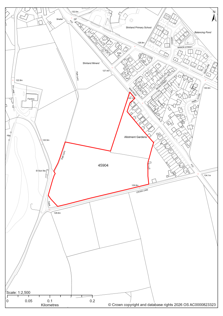
45904 – Land West of Main Road and North of Cross Lane, Shirland
- This site may be able to support approximately 120 dwellings, based on prevailing neighbouring densities, and a 20% density uplift for the most sustainable settlements. Mitigation measures have not been applied to this site capacity yet and may result in an altered total.
- The site is covered by a ‘Significant Green Gaps’ designation in the Shirland Neighbourhood Plan 2022-34. These designations will be reviewed alongside the current Local Plan’s Local Settlement Gaps in the forthcoming Local Settlement Gaps Review. This will inform the suitability of the potential development allocation sites.
- Development on the southern part of the site may have a moderate landscape impact.
- The ecology assessments find a moderate impact.
- Highway access may need to be confirmed further.
- There is some risk of surface water flooding.
- The site is located within coal authority development high risk area.
If this site were to be taken forward as an allocation, mitigation measures for the above constraints will need to be considered and any Local Plan policy text should include the requirement to address and mitigate the constraints listed above.
45841 – Land to the south of Hallfieldgate Lane, Shirland
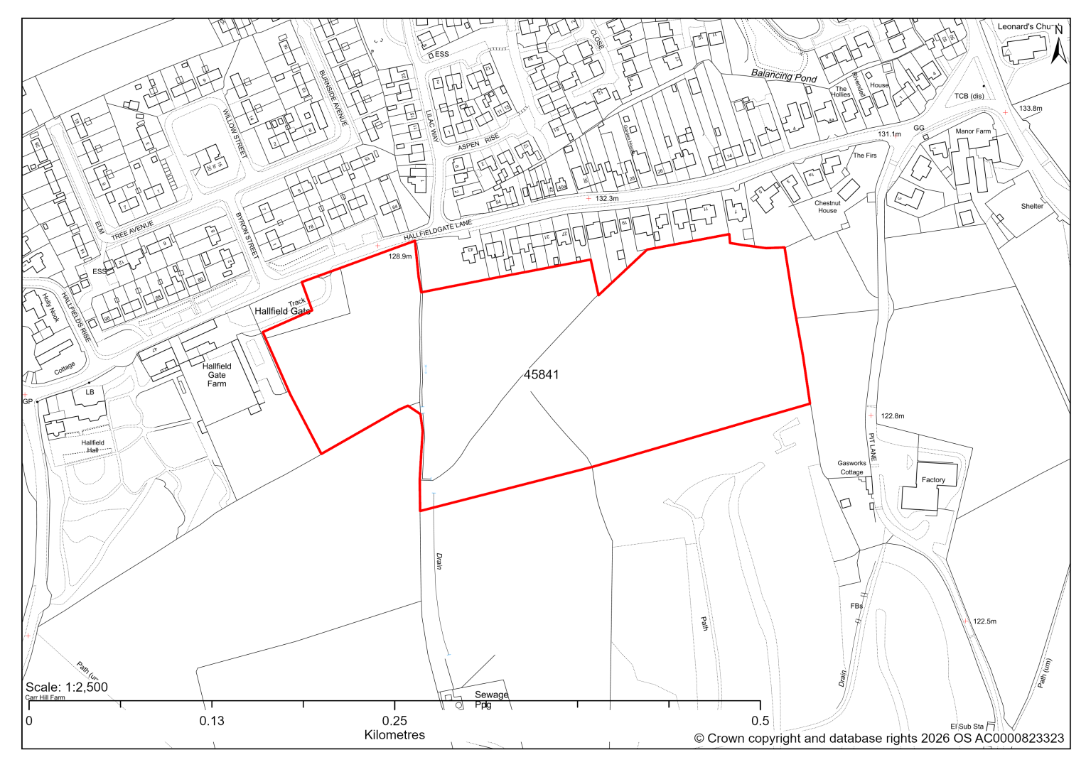
45841 – Land to the south of Hallfieldgate Lane, Shirland
The site has planning permission for 90 dwellings. At our 2025 monitoring, construction had yet to commence. 2026 monitoring information is not available yet. We are intending to allocate any major sites with planning permission, if there is a remaining capacity of 10 or more dwellings that have not been completed yet.
Stonebroom (Shirland cluster)
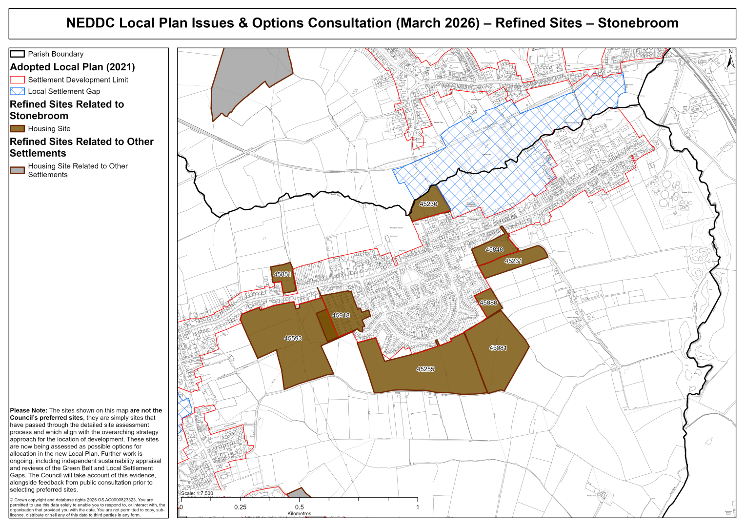
45080 – Land South of Carlyle Road, Stonebroom, Alfreton
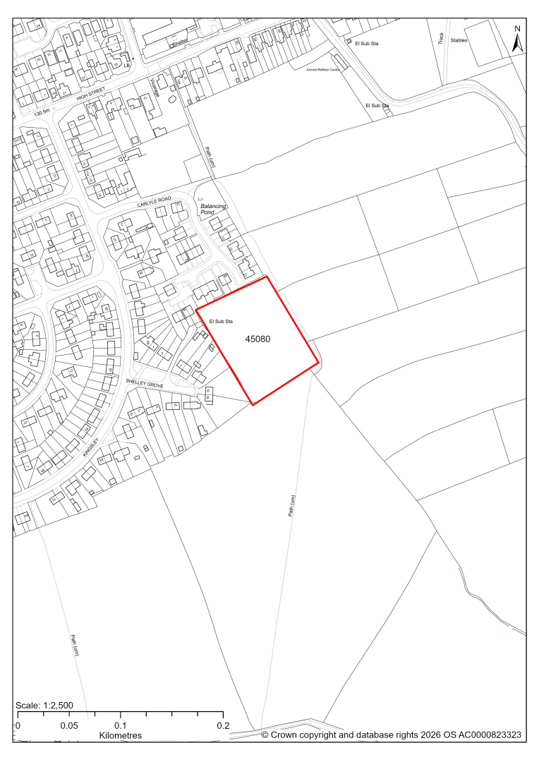
45080 – Land South of Carlyle Road, Stonebroom, Alfreton
- This site may be able to support approximately 30 dwellings, based on prevailing neighbouring densities, and a 20% density uplift for the most sustainable settlements. Mitigation measures have not been applied to this site capacity yet and may result in an altered total.
If this site were to be taken forward as an allocation, mitigation measures for the above constraints will need to be considered and any Local Plan policy text should include the requirement to address and mitigate the constraints listed above.
45081 – Land South of Carlyle Road and Shelley Grove, Stonebroom, Alfreton
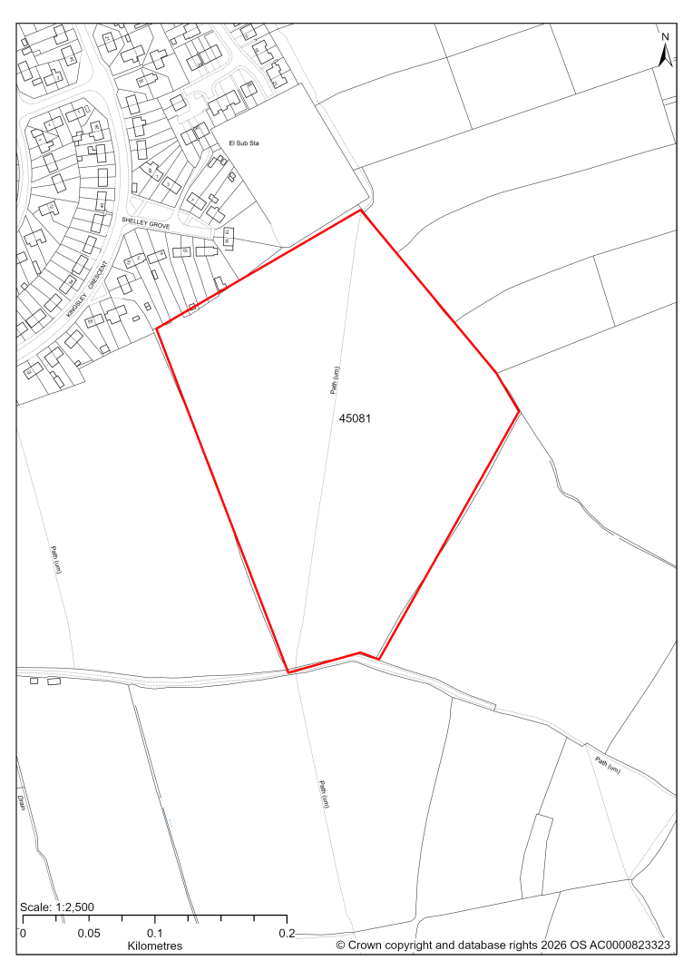
45081 – Land South of Carlyle Road and Shelley Grove, Stonebroom, Alfreton
- This site may be able to support approximately 170 dwellings, based on prevailing neighbouring densities, and a 20% density uplift for the most sustainable settlements. Mitigation measures have not been applied to this site capacity yet and may result in an altered total.
- Highway access may need to be confirmed further.
- There is some risk of surface water flooding on the site.
- A Public Right of Way crosses the site.
- The site is located within coal authority development high risk area.
If this site were to be taken forward as an allocation, mitigation measures for the above constraints will need to be considered and any Local Plan policy text should include the requirement to address and mitigate the constraints listed above.
45255 – Land to the south of Kingsley Cresent, Stonebroom
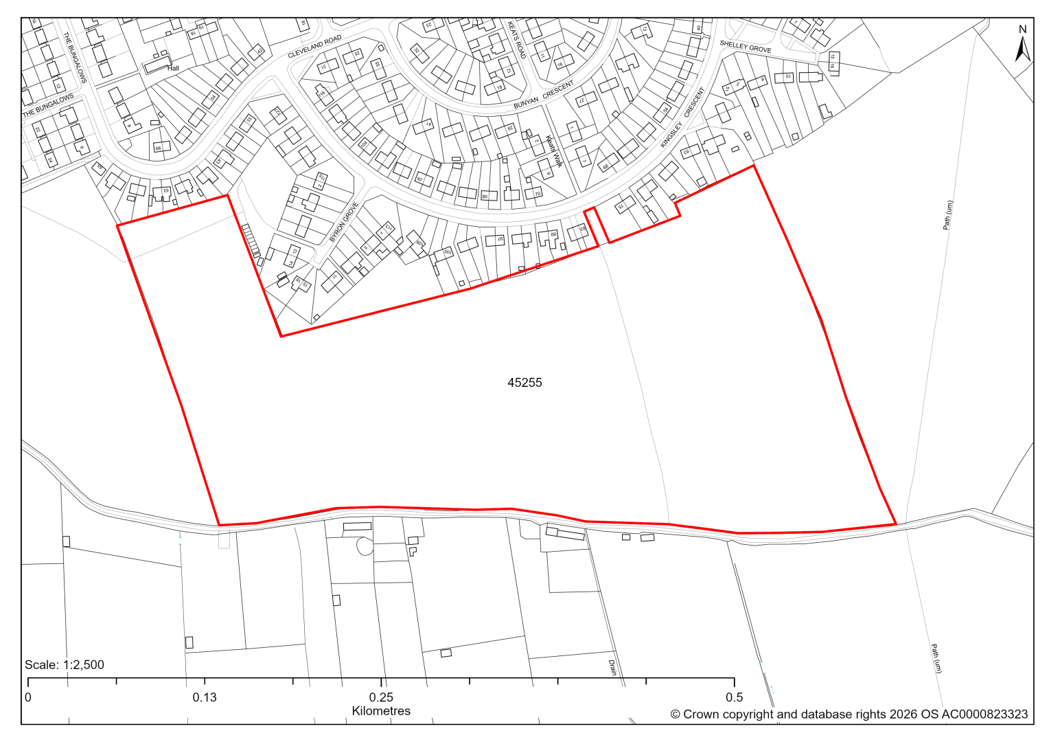
45255 – Land to the south of Kingsley Cresent, Stonebroom
- This site may be able to support approximately 250 dwellings, based on prevailing neighbouring densities, and a 20% density uplift for the most sustainable settlements. Mitigation measures have not been applied to this site capacity yet and may result in an altered total.
- The site is covered by a ‘Significant Green Gaps’ designation in the Shirland Neighbourhood Plan 2022-34. These designations will be reviewed alongside the current Local Plan’s Local Settlement Gaps in the forthcoming Local Settlement Gaps Review. This will inform the suitability of the potential development allocation sites.
- Highway access may need to be confirmed further.
- The site is at risk of some surface water flooding.
- The site is located within coal authority development high risk area.
If this site were to be taken forward as an allocation, mitigation measures for the above constraints will need to be considered and any Local Plan policy text should include the requirement to address and mitigate the constraints listed above.
45230 – Land to the North of West Street/Quarry Lane, Stonebroom
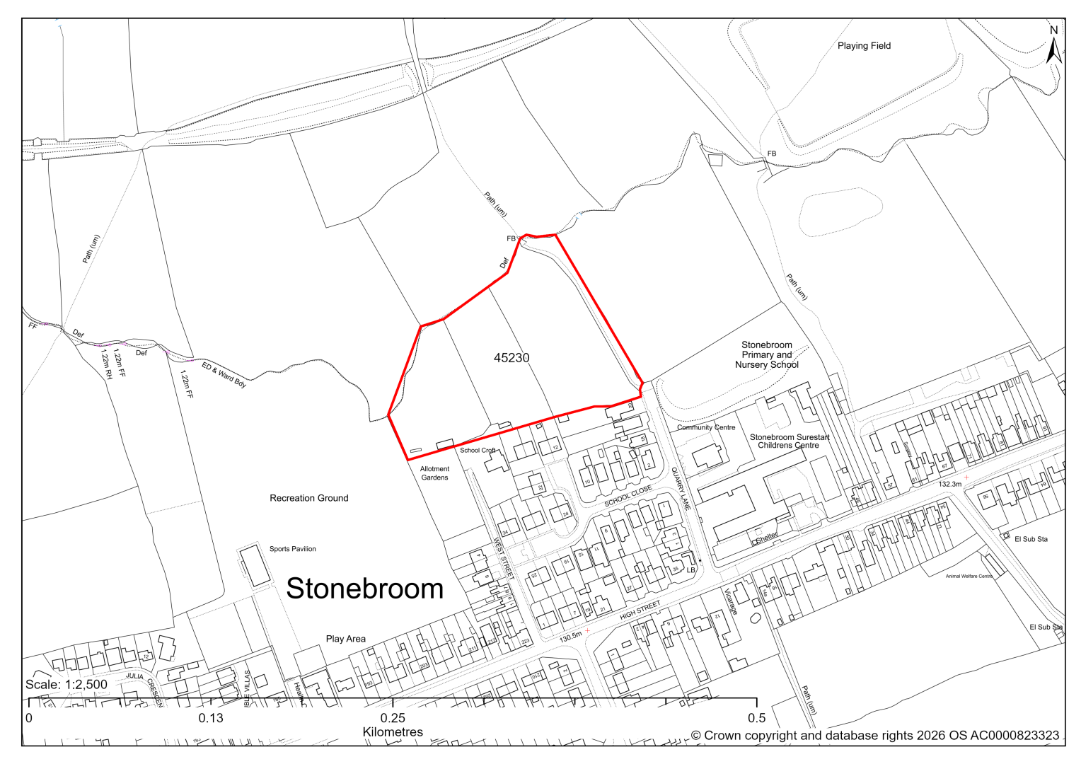
45230 – Land to the North of West Street/Quarry Lane, Stonebroom
- This site may be able to support approximately 50 dwellings, based on prevailing neighbouring densities, and a 20% density uplift for the most sustainable settlements. Mitigation measures have not been applied to this site capacity yet and may result in an altered total.
- The site is covered by a ‘Significant Green Gaps’ designation in the Shirland Neighbourhood Plan 2022-34. These designations will be reviewed alongside the current Local Plan’s Local Settlement Gaps in the forthcoming Local Settlement Gaps Review. This will inform the suitability of the potential development allocation sites.
- The site previously had outline planning permission for 29 dwellings but this permission expired. Availability will need to be confirmed.
- Desktop ecology assessments find a moderate impact. The site may in part support Lowland Meadow. A site visit will be needed in the spring to update the advice.
- There is some risk of surface water flooding on the site at the north and east of the site, concurrent with the watercourse in this location.
- A Public Right of Way crosses the site.
- The site is located within coal authority development high risk area.
If this site were to be taken forward as an allocation, mitigation measures for the above constraints will need to be considered and any Local Plan policy text should include the requirement to address and mitigate the constraints listed above.
45231 – Land off Pasture Lane Stonebroom
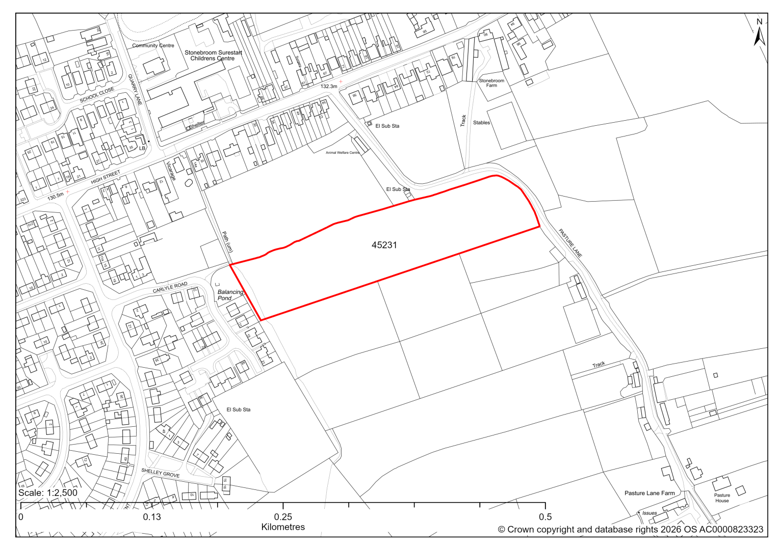
45231 – Land off Pasture Lane Stonebroom
- This site may be able to support approximately 55 dwellings, based on prevailing neighbouring densities, and a 20% density uplift for the most sustainable settlements. Mitigation measures have not been applied to this site capacity yet and may result in an altered total.
- Development on the site may have a moderate landscape impact, as it relates poorly to the existing settlement pattern, as a stand alone development. It is however located immediately adjacent to site 45848 with outline planning permission.
- Highway access may need to be confirmed further.
- A Public Right of Way crosses the site.
If this site were to be taken forward as an allocation, mitigation measures for the above constraints will need to be considered and any Local Plan policy text should include the requirement to address and mitigate the constraints listed above.
45848 – Land To The Rear Of 14A-54, High Street, Stonebroom
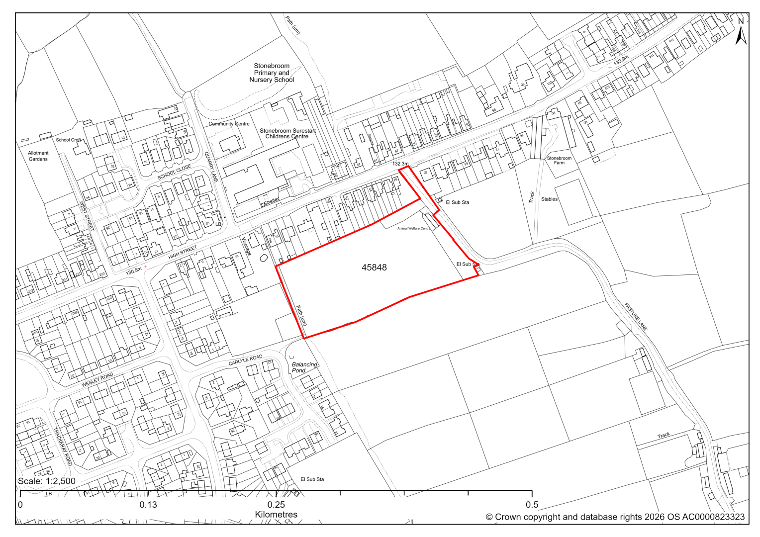
The site has planning permission for 30 dwellings. At our 2025 monitoring, construction had yet to commence. 2026 monitoring information is not available yet. We are intending to allocate any major sites with planning permission, if there is a remaining capacity of 10 or more dwellings that have not been completed yet.
45593 – Land at Stonebroom, Alfreton
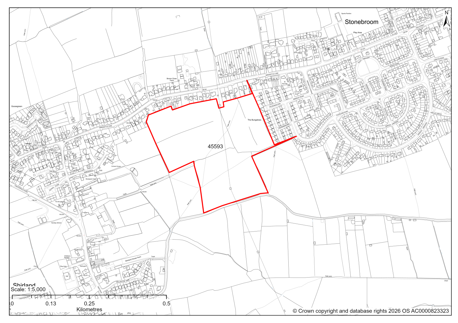
45593 – Land at Stonebroom, Alfreton
- This site may be able to support approximately 200 dwellings, based on prevailing neighbouring densities, and a 20% density uplift for the most sustainable settlements. Mitigation measures have not been applied to this site capacity yet and may result in an altered total.
- The site is covered by a ‘Significant Green Gaps’ designation in the Shirland Neighbourhood Plan 2022-34. These designations will be reviewed alongside the current Local Plan’s Local Settlement Gaps in the forthcoming Local Settlement Gaps Review. This will inform the suitability of the potential development allocation sites.
- Highway access may need to be confirmed further.
- There is some risk of surface water flooding on the site.
- Public Rights of Way cross the site.
- There are pylons and overhead power lines crossing the site.
- The site is located within coal authority development high risk area.
If this site were to be taken forward as an allocation, mitigation measures for the above constraints will need to be considered and any Local Plan policy text should include the requirement to address and mitigate the constraints listed above.
45851 – Land To The North West Of 101 Birkinstyle Lane, Shirland
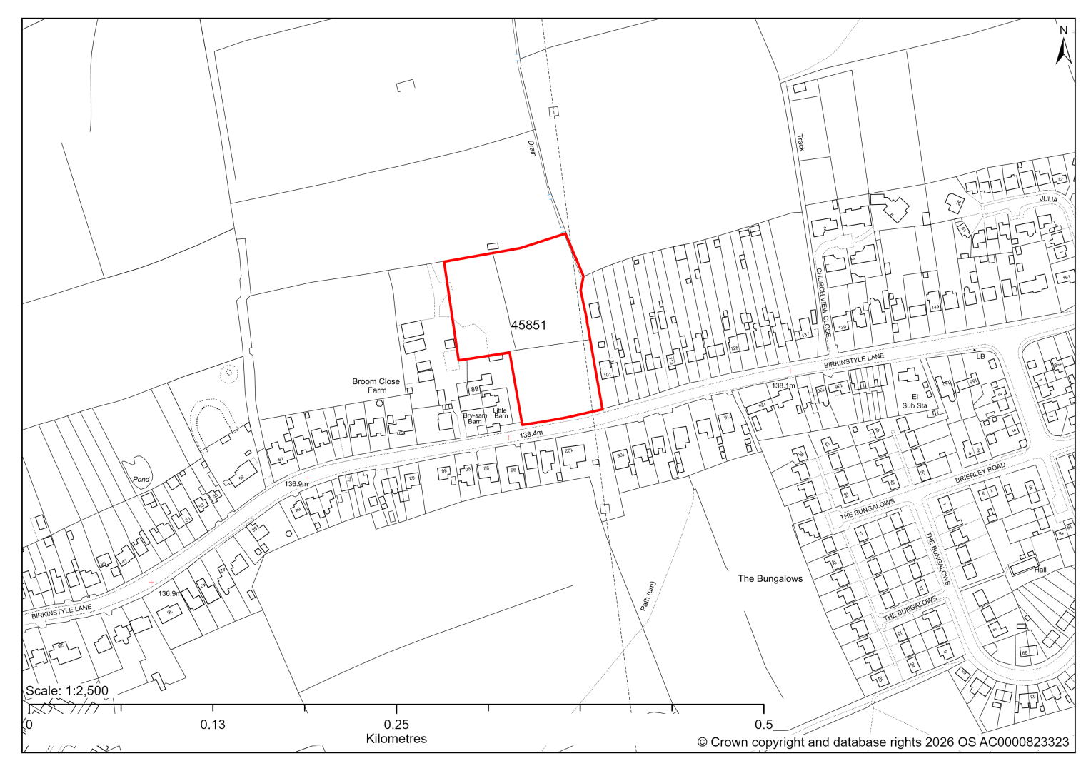
45851 – Land To The North West Of 101 Birkinstyle Lane, Shirland
The site has planning permission for 10 dwellings. At our 2025 monitoring, construction had yet to commence. 2026 monitoring information is not available yet. We are intending to allocate any major sites with planning permission, if there is a remaining capacity of 10 or more dwellings that have not been completed yet.
45918 – Street Record, The Bungalows, Stonebroom, Shirland
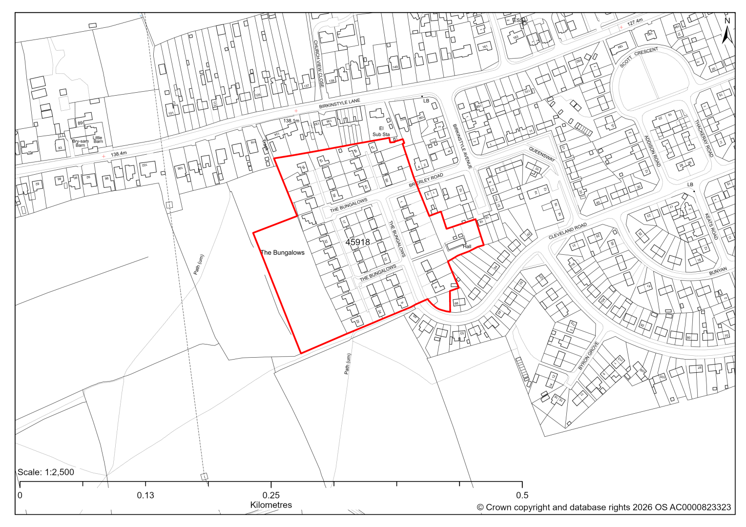
45918 - Street Record, The Bungalows, Stonebroom, Shirland
The site has planning permission for the demolition of 50 existing dwellings and the subsequent redevelopment of 69 new dwellings. At our 2025 monitoring, construction/demolition had yet to commence. 2026 monitoring information is not available yet. We are intending to allocate any major sites with planning permission, if there is a remaining capacity of 10 or more dwellings that have not been completed yet.
Tupton
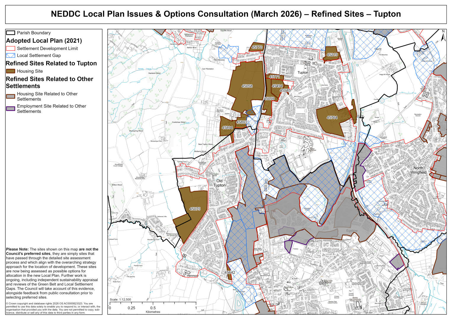
45058 – Land west of Derby Road, Tupton
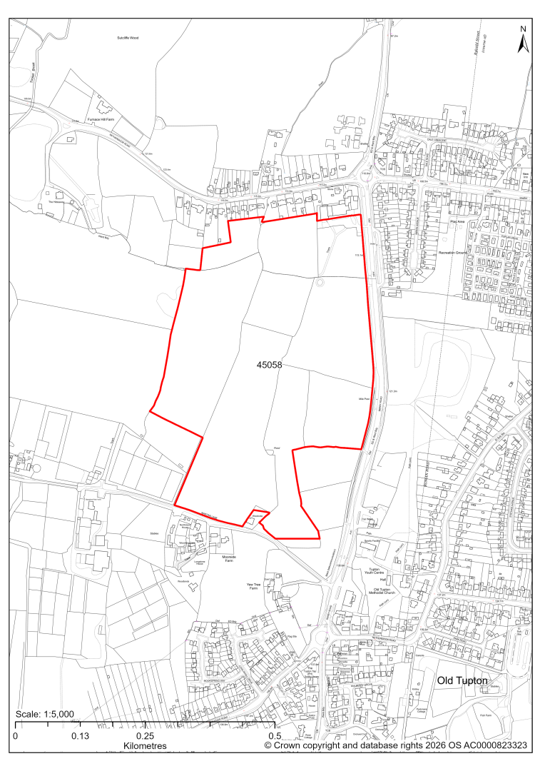
45058 – Land west of Derby Road, Tupton
- This site may be able to support approximately 340 dwellings, based on prevailing neighbouring densities, and a 20% density uplift for the most sustainable settlements. Mitigation measures have not been applied to this site capacity yet and may result in an altered total.
- Development on the site may have landscape impact, connecting Old and New Tupton. However, only 2.5% is designated as a Local Settlement Gap in the current 2014-2034 Local Plan. An updated Local Settlement Gap Review will inform whether this designation is still appropriate in its current form.
- Archaeological assessment classifies the site as having archaeological / historic environment issues, but might be suitable for allocation with appropriate site specific policy.
- There is a Listed Mile Post at the edge of the site.
- Highway access may need to be confirmed further.
- There is some risk of surface water flooding.
- The site is located within coal authority development high risk area.
If this site were to be taken forward as an allocation, mitigation measures for the above constraints will need to be considered and any Local Plan policy text should include the requirement to address and mitigate the constraints listed above.
45059 – Land east of A61, Tupton
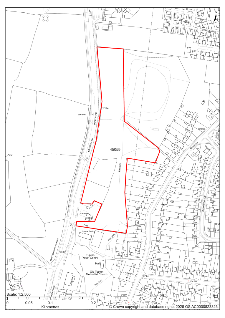
45059 – Land east of A61, Tupton
- This site may be able to support approximately 70 dwellings, based on prevailing neighbouring densities, and a 20% density uplift for the most sustainable settlements. Mitigation measures have not been applied to this site capacity yet and may result in an altered total.
- Development on the site may have a moderate landscape impact.
- Archaeological assessment classifies the site as having archaeological/historic environment issues, but might be suitable for allocation with appropriate site specific policy.
- There is a Listed Mile Post close to the site.
- The ecology assessments find a moderate impact.
- There is some risk of surface water flooding.
- Public Rights of Way cross the site.
- The site is located within coal authority development high risk area.
If this site were to be taken forward as an allocation, mitigation measures for the above constraints will need to be considered and any Local Plan policy text should include the requirement to address and mitigate the constraints listed above.
45494 – Land on the West Side of Nethermoor Road, New Tupton
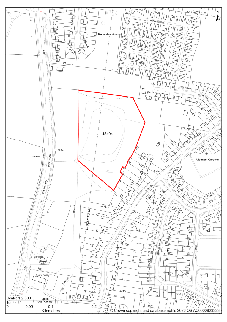
45494 – Land on the West Side of Nethermoor Road, New Tupton
- This site may be able to support approximately 50 dwellings, based on prevailing neighbouring densities, and a 20% density uplift for the most sustainable settlements. Mitigation measures have not been applied to this site capacity yet and may result in an altered total.
- Archaeological assessment classifies the site as having archaeological/historic environment issues, but might be suitable for allocation with appropriate site specific policy.
- Highway access may need to be confirmed further.
- The site is located within coal authority development high risk area.
If this site were to be taken forward as an allocation, mitigation measures for the above constraints will need to be considered and any Local Plan policy text should include the requirement to address and mitigate the constraints listed above.
45585 – Land to side of 48 Nethermoor Road, Tupton
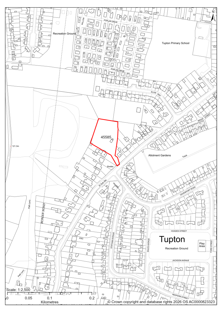
45585 – Land to side of 48 Nethermoor Road, Tupton
- This site may be able to support approximately 11 dwellings, based on prevailing neighbouring densities, and a 20% density uplift for the most sustainable settlements. Mitigation measures have not been applied to this site capacity yet and may result in an altered total.
- Highway access may need to be confirmed further.
- There is some risk of surface water flooding.
- There is a TPO tree on site and immediately adjacent to the site boundary.
- The site is located within coal authority development high risk area.
If this site were to be taken forward as an allocation, mitigation measures for the above constraints will need to be considered and any Local Plan policy text should include the requirement to address and mitigate the constraints listed above.
45075 – Land West of Coupe Lane, Old Tupton
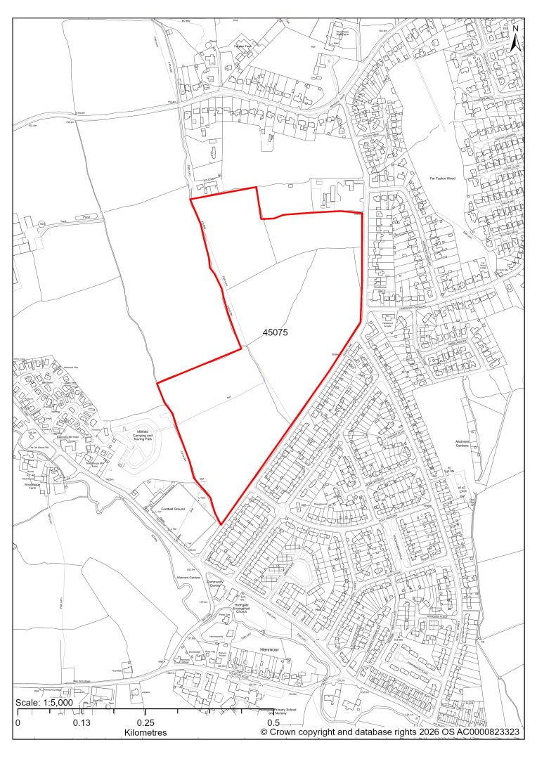
45075 – Land West of Coupe Lane, Old Tupton
- This site may be able to support approximately 250 dwellings, based on prevailing neighbouring densities, and a 20% density uplift for the most sustainable settlements. Mitigation measures have not been applied to this site capacity yet and may result in an altered total.
- An outline planning application is currently pending determination by the Council.
- Development on the site may have a moderate landscape impact.
- The ecology assessments find a moderate impact, due to the presence of hedgerows. Development would need to retain the hedgerows, with a buffer around to minimise impacts.
- There is some risk of surface water flooding.
- A Public Rights of Way crosses the site.
If this site were to be taken forward as an allocation, mitigation measures for the above constraints will need to be considered and any Local Plan policy text should include the requirement to address and mitigate the constraints listed above.
45215 – Land at 26 Queen Victoria Road, New Tupton, Chesterfield
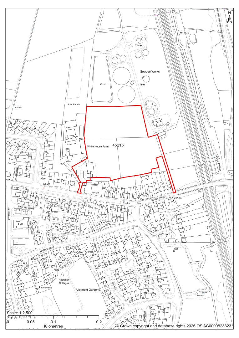
45215 – Land at 26 Queen Victoria Road, New Tupton, Chesterfield
- This site may be able to support approximately 80 dwellings, based on prevailing neighbouring densities, and a 20% density uplift for the most sustainable settlements. Mitigation measures have not been applied to this site capacity yet and may result in an altered total.
- Highway access may need to be confirmed further.
- The site is at risk of some surface water flooding.
- A sewage treatment works is located to the north east of the site.
- The site is located within coal authority development high risk area.
If this site were to be taken forward as an allocation, mitigation measures for the above constraints will need to be considered and any Local Plan policy text should include the requirement to address and mitigate the constraints listed above.
45642 – Land off Holmgate Road, Clay Cross (2014-34 LP Allocation CC3)
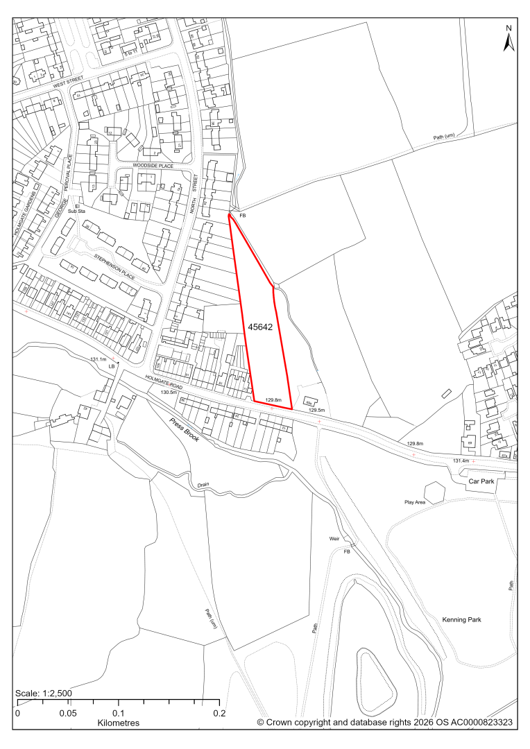
45642 – Land off Holmgate Road, Clay Cross (2014-34 LP Allocation CC3)
- This site may be able to support approximately 15 dwellings, based on prevailing neighbouring densities, and a 20% density uplift for the most sustainable settlements. Mitigation measures have not been applied to this site capacity yet and may result in an altered total.
- The site is a housing allocation in the current 2014-2034 Local Plan.
- Availability will need to be confirmed with the landowner.
- There is some risk of surface water flooding, in the northern part of the site.
- A proposed cycle route and greenway cross the site.
- The site is located within coal authority development high risk area.
If this site were to be taken forward as an allocation, mitigation measures for the above constraints will need to be considered and any Local Plan policy text should include the requirement to address and mitigate the constraints listed above.
45764 – Land to the North and West of The Poplars, Ankerbold Road, Tupton
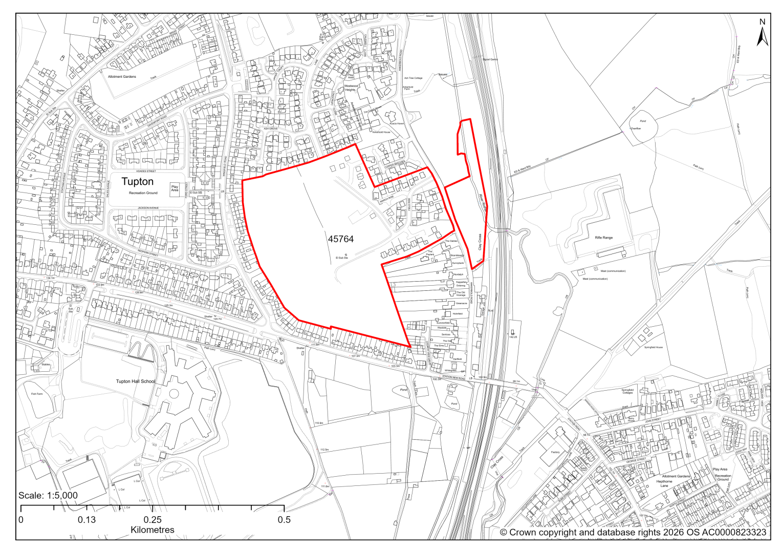
45764 – Land to the North and West of The Poplars, Ankerbold Road, Tupton
The site has planning permission for 193 dwellings. At our 2025 monitoring, another 184 dwellings were yet to be completed. 2026 monitoring information is not available yet. We are intending to allocate any major sites with planning permission, if there is a remaining capacity of 10 or more dwellings that have not been completed yet.
A planning application is currently pending for a replan of approved scheme, with an additional 48 plots.
45770 – Land at Rear of 263 Nethermoor Road, Wingerworth
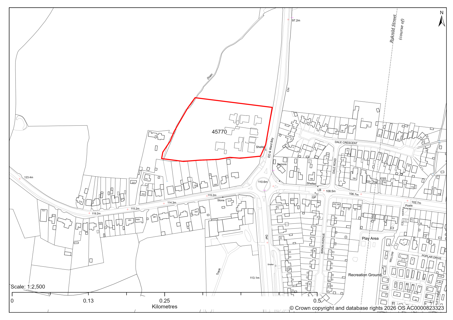
45770 – Land at Rear of 263 Nethermoor Road, Wingerworth
The site has planning permission for 17 dwellings. 2026 monitoring information is not available yet. We are intending to allocate any major sites with planning permission, if there is a remaining capacity of 10 or more dwellings that have not been completed yet.
45771 – South of Sunningdale Park and Birkin Park, Birkin Avenue, Tupton
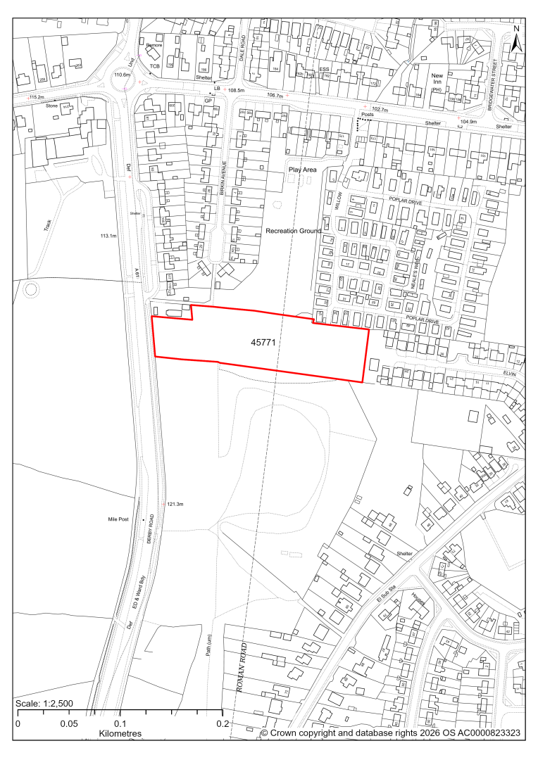
45771 – South of Sunningdale Park and Birkin Park, Birkin Avenue, Tupton
The site has planning permission for 32 residential park homes. At our 2025 monitoring, a material start had been made, but no homes were completed. 2026 monitoring information is not available yet. We are intending to allocate any major sites with planning permission, if there is a remaining capacity of 10 or more dwellings that have not been completed yet.
45893 – Land Lying to the North of Ashover Road, Old Tupton, Chesterfield
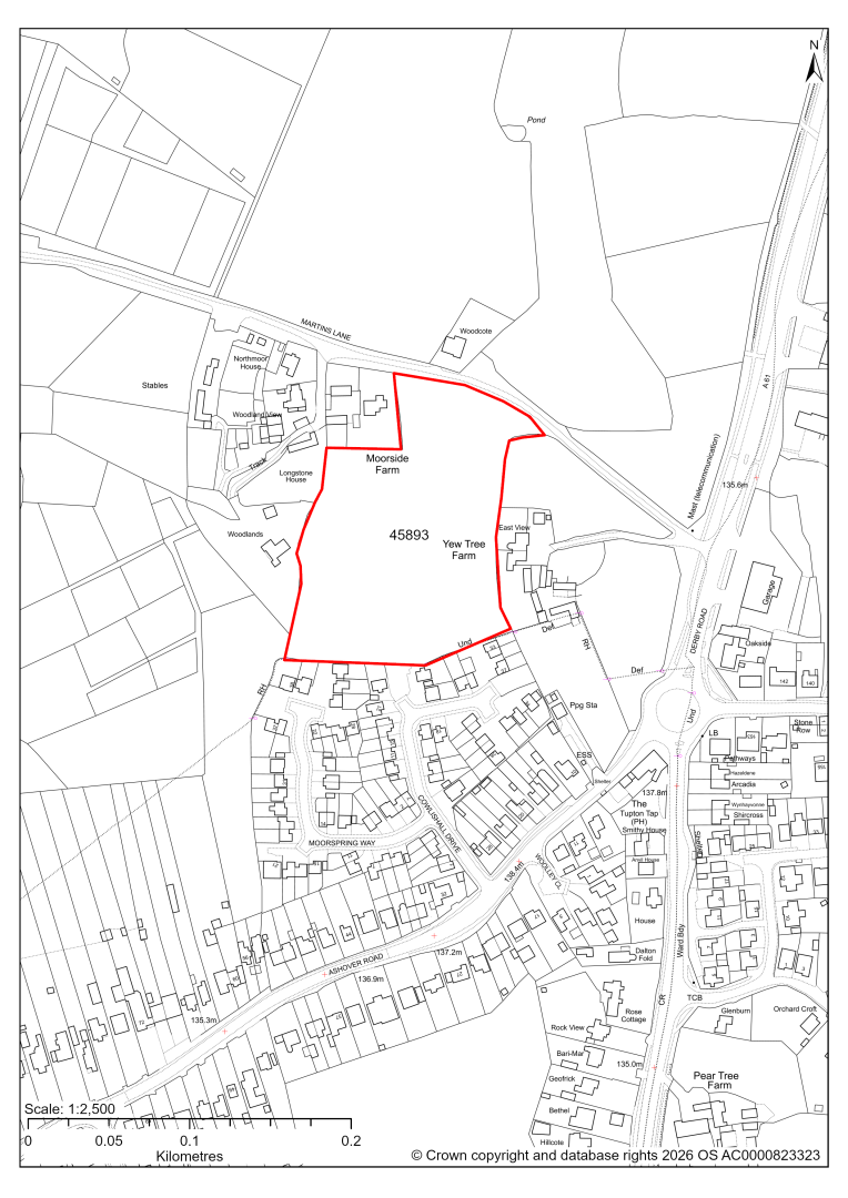
45893 – Land Lying to the North of Ashover Road, Old Tupton, Chesterfield
- This site may be able to support approximately 35 dwellings, based on prevailing neighbouring densities, and a 20% density uplift for the most sustainable settlements. Mitigation measures have not been applied to this site capacity yet and may result in an altered total.
- Development on the site may have a moderate landscape impact.
- Highway access may need to be confirmed further.
- The site is at risk of some surface water flooding.
- The site is located within coal authority development high risk area.
If this site were to be taken forward as an allocation, mitigation measures for the above constraints will need to be considered and any Local Plan policy text should include the requirement to address and mitigate the constraints listed above.
45894 – Woodlands, Martins Lane, Old Tupton, Chesterfield
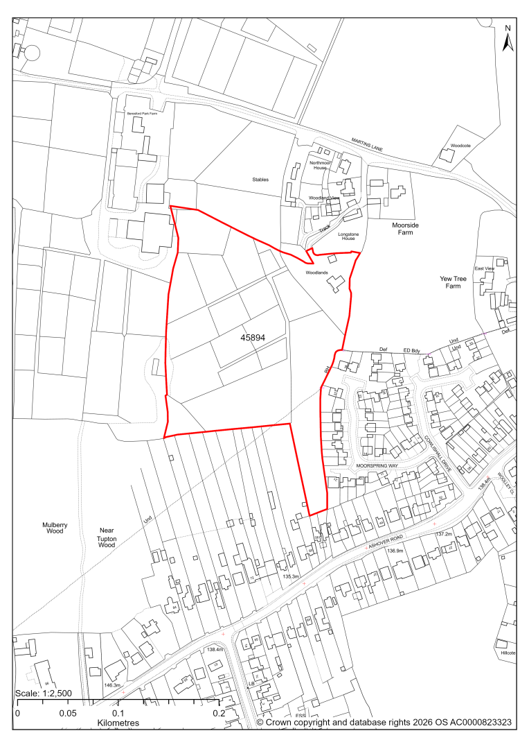
45894 – Woodlands, Martins Lane, Old Tupton, Chesterfield
- This site may be able to support approximately 60 dwellings, based on prevailing neighbouring densities, and a 20% density uplift for the most sustainable settlements. Mitigation measures have not been applied to this site capacity yet and may result in an altered total.
- Desktop ecology advice finds a low / medium impact level of development upon biodiversity. A site visit will be needed in the spring.
- The south western part of the site is covered by a TPO Area.
- Highway access may need to be confirmed further.
- There is some risk of surface water flooding.
- The site is located within coal authority development high risk area.
If this site were to be taken forward as an allocation, mitigation measures for the above constraints will need to be considered and any Local Plan policy text should include the requirement to address and mitigate the constraints listed above.
Wingerworth
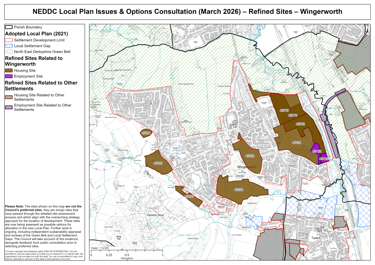
45050 – Bellfitt Hill Farm, Birkin Lane, Wingerworth
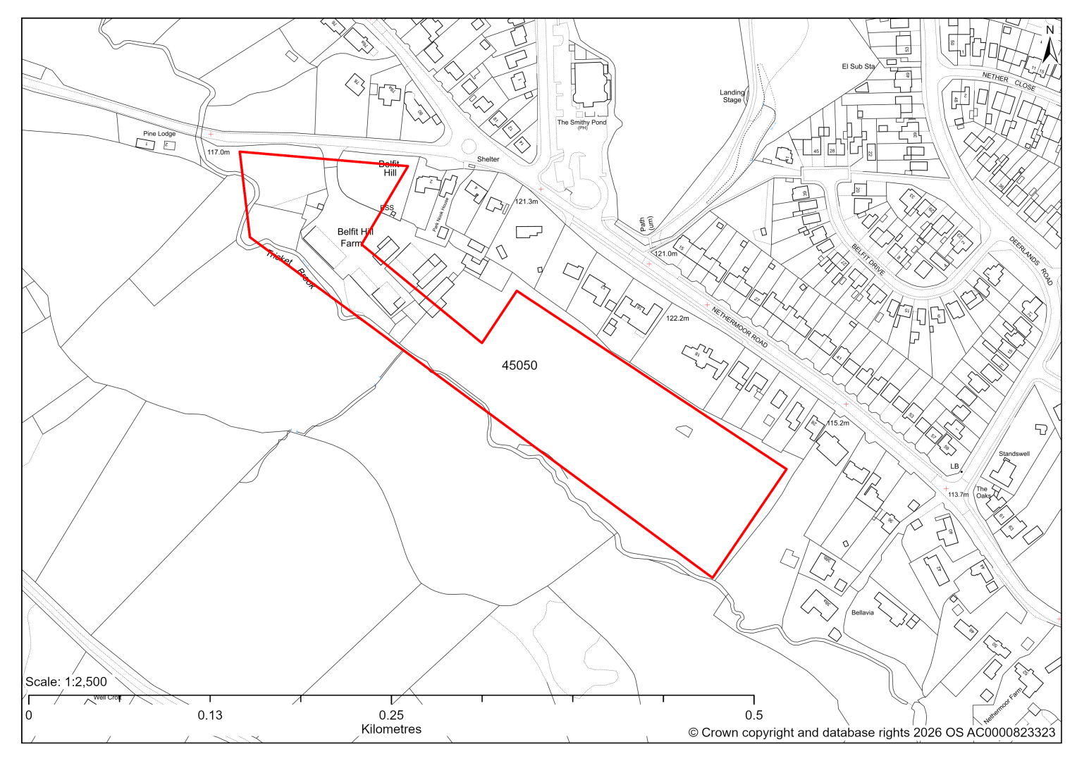
45050 – Bellfitt Hill Farm, Birkin Lane, Wingerworth
- This site may be able to support approximately 20 dwellings, based on prevailing neighbouring densities, and a 20% density uplift for the most sustainable settlements. Mitigation measures have not been applied to this site capacity yet and may result in an altered total.
- Landscape assessment is yet to take place.
- The ecology assessments find a moderate impact, in relation to the wooded corridor of Trickett Brook. It recommends putting a buffer in place around the watercourse to avoid any direct and indirect impacts to associated wildlife and maintain its value as a habitat corridor.
- Highway access may need to be confirmed further.
- Approximately 15% of the site is located within flood risk zones 2 and 3, in the south west of the site, along the watercourse. There is also some risk of surface water flooding.
If this site were to be taken forward as an allocation, mitigation measures for the above constraints will need to be considered and any Local Plan policy text should include the requirement to address and mitigate the constraints listed above.
45109 – Hill Houses Farm, New Road, Wingerworth
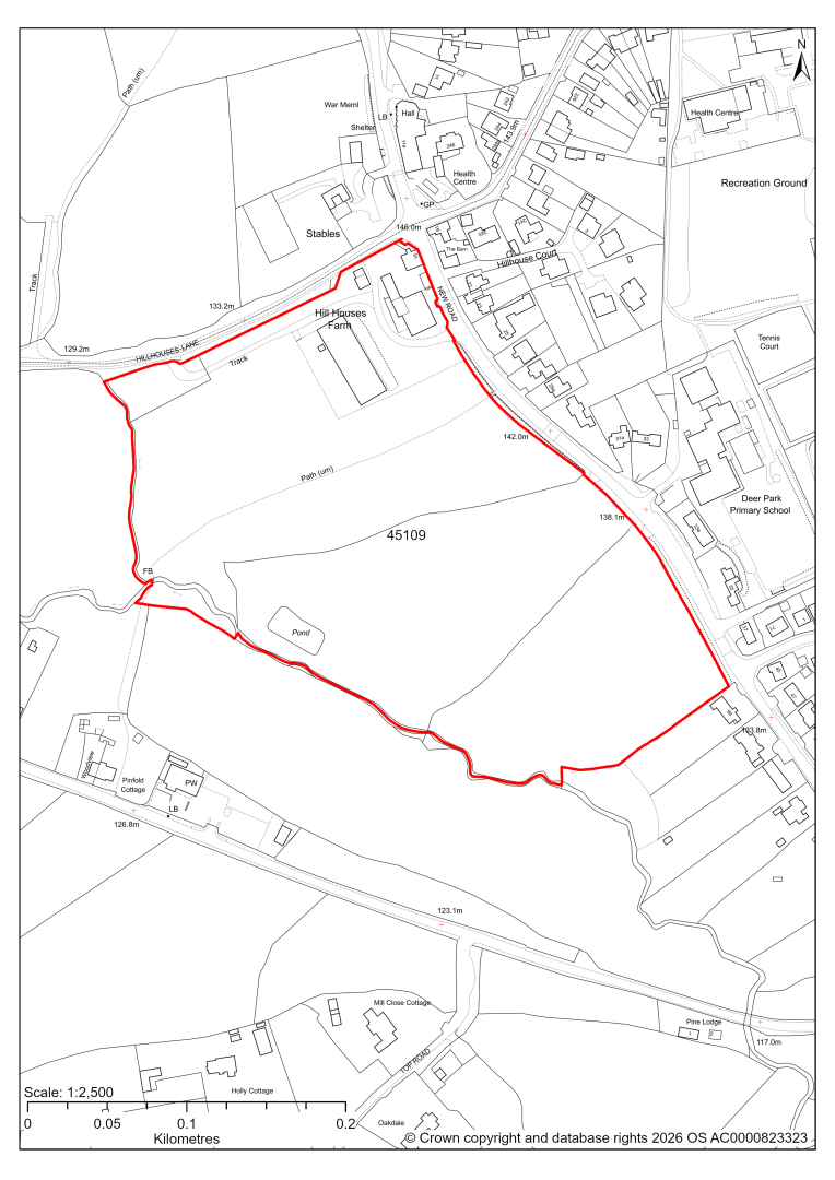
45109 – Hill Houses Farm, New Road, Wingerworth
- This site may be able to support approximately 70 dwellings, based on prevailing neighbouring densities, and a 20% density uplift for the most sustainable settlements. Mitigation measures have not been applied to this site capacity yet and may result in an altered total.
- Development on the site may have a moderate landscape impact. Mitigation should include a comprehensive landscape scheme that reinforces the character of the Wooded Farmlands Landscape Character Type and contributes to high quality Green Infrastructure.
- The site is in close proximity to Grade II Listed Buildings on New Road.
- Archaeological assessment classifies the site as having archaeological/historic environment issues, but might be suitable for allocation with appropriate site specific policy.
- The ecology assessments find a high impact around Trickett Brook. It recommends putting a buffer in place around the watercourse to avoid any direct and indirect impacts to associated wildlife and maintain its value as a habitat corridor.
- Highway access may need to be confirmed further.
- Approximately 5% of the site is located within flood risk zones 2 and 3, in the south west of the site, along the watercourse. There is also some risk of surface water flooding.
- A Public Rights of Way crosses the site.
If this site were to be taken forward as an allocation, mitigation measures for the above constraints will need to be considered and any Local Plan policy text should include the requirement to address and mitigate the constraints listed above.
45201 – Land east of Langer Lane, Wingerworth
45201 – Land east of Langer Lane, Wingerworth
- This site may be able to support approximately 25 dwellings, based on prevailing neighbouring densities, and a 20% density uplift for the most sustainable settlements. Mitigation measures have not been applied to this site capacity yet and may result in an altered total.
- Development on the site may have a moderate landscape impact. The land would be visible in the wider landscape particularly from higher land to the west, but this would be within the context of the built edge of Wingerworth. The site in isolation doesn't relate well to the existing settlement pattern of Wingerworth.
- Highway access may need to be confirmed further.
- The site is at risk of some surface water flooding.
If this site were to be taken forward as an allocation, mitigation measures for the above constraints will need to be considered and any Local Plan policy text should include the requirement to address and mitigate the constraints listed above.
45229 – Land South of Nottingham Drive, Wingerworth
45229 – Land South of Nottingham Drive, Wingerworth
- This site may be able to support approximately 170 dwellings, based on prevailing neighbouring densities, and a 20% density uplift for the most sustainable settlements. Mitigation measures have not been applied to this site capacity yet and may result in an altered total.
- Availability of the site for development will need to be confirmed by the landowner.
- Development on the site may have a moderate landscape impact.
- Archaeological assessment classifies the site as having archaeological / historic environment issues.
- The site is in close proximity to several Grade I and Grade II Listed Buildings.
- The ecology assessments find a medium impact in relation to the proximity of the Local Wildlife Site and woodland habitats. It recommends putting a buffer in place with semi-natural greenspace between the development and the woodland.
- There are also some mature trees, some with TPOs in the north of the site.
- Highway access may need to be confirmed further.
- Approximately 5% of the site is located within flood risk zones 2 and 3, in the south west of the site, along the watercourse. There is also some risk of surface water flooding.
- Natural England’s provisional agricultural land classification of the southern area is grade 3.
- The site is located within coal authority development high risk area.
If this site were to be taken forward as an allocation, mitigation measures for the above constraints will need to be considered and any Local Plan policy text should include the requirement to address and mitigate the constraints listed above.
45238 – Land north of Spindle Drive and East Deerlands Road, Wingerworth
45238 – Land north of Spindle Drive and East Deerlands Road, Wingerworth
- This site may be able to support approximately 180 dwellings, based on prevailing neighbouring densities, and a 20% density uplift for the most sustainable settlements. Mitigation measures have not been applied to this site capacity yet and may result in an altered total.
- The Council has currently provided a resolution to grant permission for 180 houses in the western part of the site.
- The eastern part of the site has several major constraints, such as ecology, flooding and highways, that makes development unlikely to be suitable.
If this site were to be taken forward as an allocation, mitigation measures for the above constraints will need to be considered and any Local Plan policy text should include the requirement to address and mitigate the constraints listed above.
45776, 45779 and 45782 – The Former Avenue Site, Wingerworth

45776, 45779 and 45782 – The Former Avenue Site, Wingerworth
- 45776: outline planning permission for 489 dwellings and 2.8 hectares of employment land. 20 dwellings do not have detailed planning permission yet. We are intending to allocate any major sites with planning permission, if there is a remaining capacity of 10 or more dwellings that have not been completed yet.
- The site is located within the Green Belt and will be assessed through a new Green Belt Review to identify the extent to which the site meets Green Belt purposes a, b & d (related to checking unrestricted sprawl, preventing neighbouring towns merging and preserving the setting and special character of historic towns). The review will identify whether the site is Grey Belt and will inform decisions over whether, or not, Green Belt boundaries should be amended to account for development needs – as required by the National Planning Policy Framework (2024).
- For information, the 2016/17 Green Belt Review showed that this site (which lies within a smaller part of GB land parcel: WW/GB/016) performed strongly against Green Belt purposes a & b and weaker against purpose d. Please note: the new Green Belt Review will follow the detailed methodology set out in recent National Planning Practice Guidance, which differs to the approach taken in the 2016/17 review, in terms of assessment criteria and what can be considered to be a town). For this reason, the land parcel results may differ.
- 45779: The site has detailed planning permission for housing development and is under construction. At our 2025 monitoring, another 54 dwellings were yet to be completed. 2026 monitoring information is not available yet. We are intending to allocate any major sites with planning permission, if there is a remaining capacity of 10 or more dwellings that have not been completed yet.
- 45782: The site has detailed planning permission for housing development. At our 2025 monitoring, the construction of 217 dwellings had yet to commence. 2026 monitoring information is not available yet. We are intending to allocate any major sites with planning permission, if there is a remaining capacity of 10 or more dwellings that have not been completed yet.
- The remaining land has been included as sites for employment uses - 45442 and 45443.
45442 – Land at The Avenue, Wingerworth
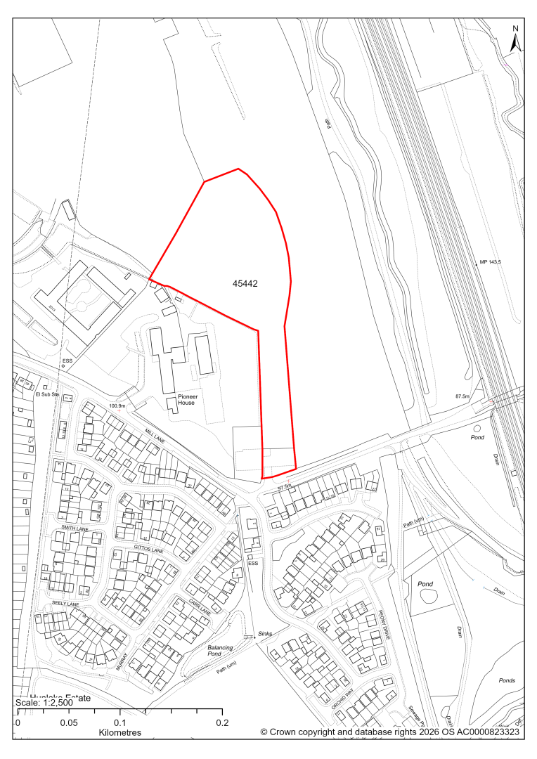
45442 – Land at The Avenue, Wingerworth
- This site comprises approximately 1.80 hectares of land on the southern part of the Avenue site which is identified as a strategic mixed-use site in the current 2014-2034 Local Plan. The site could support employment development.
- Desktop ecology assessments find the site supports woodland, scrub, grassland and open mosaic habitat on previously developed land. It identifies a high impact of development and recommends reducing impacts through retaining key areas of habitat and enhancing or creating new areas of habitat. Site visits will further determine ecology impacts.
- Creating an access from Mill Lane would require some widening of the road and removal of a section of hedgerow.
- Approximately 3% of the site is at risk of surface water flooding.
If this site were taken forward as an employment allocation, mitigation measures for the above constraints will need to be considered and any Local Plan policy text should include the requirement to address and mitigate the constraints listed above.
45443 – Land at The Avenue, Wingerworth
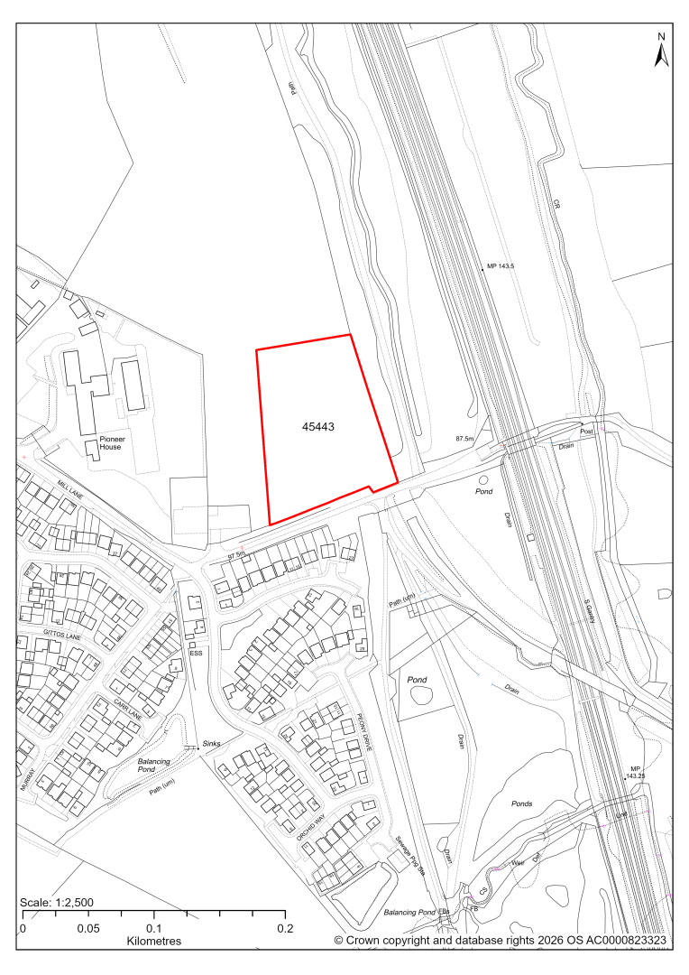
45443 – Land at The Avenue, Wingerworth
- This site comprises approximately 1.1 hectares of land on the southern part of the Avenue site which is identified as a strategic mixed-use site in the current 2014-2034 Local Plan. The site could support employment development.
- The eastern part of the site is a Local Wildlife Site. Desktop ecology assessment has identified the main habitats on the site as woodland, scrub, grassland and open mosaic habitats on previously developed land and that development may have high / medium level impact. Site visit will further determine ecology impacts.
- Creating a new access from Mill Lane would require the road to be widened, and the change in land levels between road and the site would need to be addressed.
If this site were taken forward as an employment allocation, mitigation measures for the above constraints will need to be considered and any Local Plan policy text should include the requirement to address and mitigate the constraints listed above.
45638 – The Avenue Strategic Site (2014-2034 LP allocation SS3 remaining land)
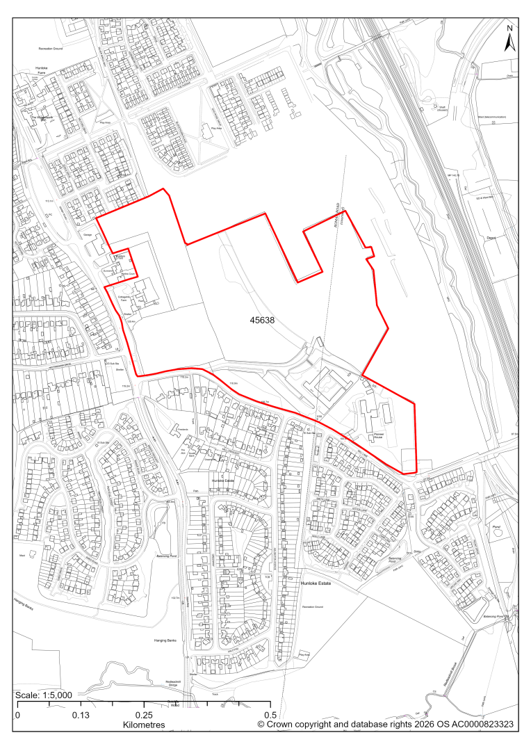
45638 – The Avenue Strategic Site (2014-2034 LP allocation SS3 remaining land)
- This site may be able to support approximately 375 dwellings, based on prevailing neighbouring densities, and a 20% density uplift for the most sustainable settlements. Mitigation measures have not been applied to this site capacity yet and may result in an altered total.
- The wider Avenue Strategic Site is allocated within the current 2014-2034 Local Plan. Approximately half of the site has planning permission, has been built out or is set aside for employment use (see sites 45776, 45779, 45782, 45442 and 45443). The remaining land does not have planning permission and is included here.
- The Council Offices themselves are not available for redevelopment.
- The ecology assessments find both low, medium and high biodiversity interests. As it is a large site, there may be possibilities to mitigate through site design, including opportunities to include biodiversity net gain.
- Highway access may need to be confirmed further.
- There is some risk of surface water flooding.
- Natural England’s provisional agricultural land classification of the western area is grade 3.
- The site is located within coal authority development high risk area.
If this site were to be taken forward as an allocation, mitigation measures for the above constraints will need to be considered and any Local Plan policy text should include the requirement to address and mitigate the constraints listed above.