NEDDC Local Plan Issues and Options Consultation on the Strategic Approach to the Location of Development and Refined Sites (March 2026)
North East Derbyshire Local Plan: Issues & Options Consultation on the Strategic Approach to the Location of Development and Refined Schedule of Sites (Regulation 18 of The Town & Country Planning (Local Planning) (England) Regulations, 2012
12 March – 30 April 2026
Executive Summary
We received a very healthy response to the Issues and Options consultation last summer and we were grateful for the feedback received. We understand that we asked a lot of questions, but we wanted to ensure that we got your views on as many issues as possible at the beginning of the process.
We understand that the level of change that this Local Plan has to respond to is challenging, but it is vital that we have a document that effectively directs development to the most appropriate locations in the district. We can only do that by developing a strategy that can respond to the challenges that we face now, but also those that we foresee in the future.
We know that there are lots of people in need of an affordable home (see housing needs assessment) and we also know that the government requires us to work on a strategy to deliver circa 600 homes a year to meet our housing target, before we consider any other options.
The Local Plan has to respond to these challenges in order to be fit for purpose. It also needs to consider where we locate new employment opportunities, how we enhance the biodiversity value of the district and how the impacts of new development can be reduced through increasing the capacity of public services (e.g. GP surgeries and schools, highway capacity etc).
We have considered the comments received to the consultation that took place last summer and are now consulting on a proposed strategic approach to the location of new development in the district & a refined schedule of sites.
Defining the strategic approach is the critical first stage as this is the filter through which potential development sites will be assessed for their suitability for allocation in the Local Plan, which will make it more likely that a site will eventually come forward to be developed.
As well as seeking your feedback on the strategic approach, we are giving you the opportunity to comment on the sites that have passed through initial screening in terms of high-level constraints, including impacts on ecology, landscape and highway safety for example. These constraints checks are ongoing and have not been concluded. That is why we are calling the site options a ‘refined list’ - we are not yet in a position to know which will be suitable for inclusion in the Publication Draft Local Plan, which we will consult on in September this year.
Further important evidence base work is also progressing in a number of areas, but a key one to highlight is the Green Belt Review. A number of the sites still under consideration are in the Green Belt. National policy requires us to consider all reasonable options outside of the designated Green Belt (located in the north of the district and around the edges of Chesterfield) first, before we consider sites in the Green Belt.
We have not yet received the outcome of our current Green Belt Review, and we will need that to make an assessment as to which sites may be suitable for release from the Green Belt and allocation in the Plan, provided that exceptional circumstances can be demonstrated. For the purposes of this consultation, we have made reference to the assessment of the previous review, in so far as it affects the refined list of sites that are included in this consultation. We have been clear however that the methodology for assessing the impact on the Green Belt has changed and this may well lead to differing conclusions between the previous Green Belt review and the emerging one that will form part of the evidence base for this Local Plan.
The emerging Green Belt Review will be made available as part of the consultation on the Publication Draft Local Plan later this year.
We appreciate your time in providing us with feedback and will consider your comments as we work towards a draft version of the Local Plan.
Introduction
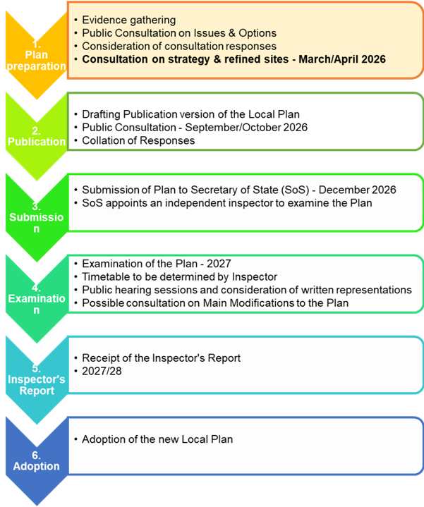
North East Derbyshire District Council (the Council) is preparing a new Local Plan to replace the current plan that was adopted in November 2021. The current Local Plan (2014 - 2034) will continue to be the development plan for the area and will be used in the determination of planning applications until a new Local Plan is adopted by the Council.
The stages involved in plan-making are illustrated in Figure 1, which shows that this consultation will be the final step in stage 1, following on from the Issues and Options consultation that took place last year (19th June – 14th August 2025) and which focussed upon on a wide range of policy areas and sites that had been submitted for consideration for development, along with associated supporting information.
The Consultation Statement published alongside this document provides details of the community consultation and stakeholder involvement that has taken place to date, setting out who was consulted, when and how alongside a summary of the main issues raised during consultations.
Although we are still in the early stages of preparing the new plan, things have moved forward in the period since last summer’s consultation. Further evidence base work has progressed, we have analysed the feedback from consultation and held focus groups with stakeholders to help us to gain a deeper understanding of the issues and responses to consultation. At the same time, we have been reviewing the submitted sites in the context of the developing the strategic approach of the Plan and feedback from specialist consultees (to understand their availability, achievability and deliverability).
This consultation is focussed upon:
- the Strategic Approach to the Location of Development, that is, those matters that determine the direction of the Local Plan and set the context for more detailed policies and site allocations; and
- A refined schedule of sites that have passed through both the initial desk top screening, and further detailed stages of assessment; and which align with the emerging strategy approach.
Approach to Consultation
We are inviting your views on the proposed strategic policy approach to the location of development and the refined sites outlined in this document.
To make comments please click on the "comment" button in front of the relevant heading, settlement or site name to leave your comments.
Your feedback will inform the development of detailed polices and proposals that will be published for consultation later this year.
Please note you do not need to answer all questions and can respond to as many or as few as you wish.
Please Note: We will publish all comments received along with our responses through the on-line consultation system and Consultation Statements where appropriate. Copies of all comments received will be made available for the public to view and cannot be treated as confidential. Personal data will however be processed and held in accordance with the General Protection Regulation (GDPR) 2018 and Data Protection Act 2018. The Council assumes that by making comments to planning policy documents, you opt-in to receiving further updates from the Council about future planning policy documents. If you no longer wish to receive updates, you can opt-out of receiving these by contacting the Council’s Planning Policy and Environment Team. The Council will keep Local Plan comments and personal data on record in line with the retention schedule. Please view the Council’s Planning Privacy Statement for further information.
If you submit additional information with your comments, please ensure that this does not contain personal information.
© Crown copyright and database rights 2026 OS AC0000823323. You are granted a non-exclusive, royalty free, revocable licence solely to view the Licensed Data for non-commercial purposes for the period during which North East Derbyshire District Council makes it available. You are not permitted to copy, sub-license, distribute, sell, or otherwise make available the Licensed Data to third parties in any form. Third party rights to enforce the terms of this licence shall be reserved to OS.
All comments must be made by the closing date of 30th April 2026.
Strategic Approach to the Location of Development
This issue relates to the main strategic matters associated with the amount and overall distribution of development, the approach to settlements and the spaces between them. It sets the strategic context of the Plan that will shape the future of development in the district.
Development Needs - Context
The National Planning Policy Framework (NPPF) includes a presumption in favour of sustainable development to ensure it is pursued positively (paragraph 11). For plan-making, this means promoting sustainable development patterns and providing for objectively assessed needs for housing and other uses, as well as unmet needs from neighbouring areas, unless protected assets or adverse impacts justify restrictions, based on the NPPF as a whole.
In terms of development needs, the majority of respondents to the previous consultation indicated a preference for lower levels of housing and employment within the district, which would involve seeking a lower than standard method housing target, and a lower, but within ‘range’ employment target. At this stage no final decisions have been made around the amount of housing or employment development that we are planning for. However, it is important to bear in mind the information in this section, which sets some important context for this consultation, specifically in relation to housing needs.
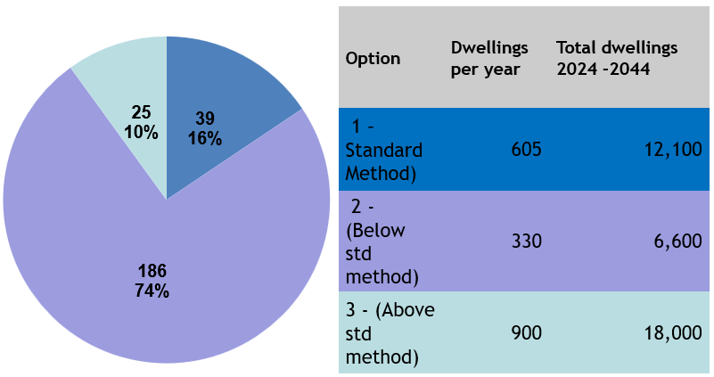
The National Planning Policy Framework (NPPF) is clear that meeting an area’s identified housing need is crucial to achieving the Government’s objective of significantly boosting the supply of homes; and that housing need should be assessed through the application of the standard method. This generates a figure of approximately 600 dwellings per annum for North East Derbyshire and has generated widespread objections from the local community, with almost 75% of respondents to the previous consultation preferring a lower target.
The Council must make every attempt to meet the standard method housing target, including considering all possible sustainable locations for development and undertaking a Green Belt Review. A Green Belt Review is currently underway and is scheduled for completion in the Summer. Only when we have the full suite of evidence will we be able to see whether we will have a realistic chance of accommodating this level of development, or whether we would need to be arguing for lower than standard method figure.
For this reason, the current consultation is based on meeting the overall housing target set by the standard method: 12,000 dwellings over the period 2024 – 2044.
Comments are not being invited on this matter at this time.
Spatial Distribution of Development
The previous consultation included questions on a range of matters that influence the overall approach to the spatial distribution of development including:
- Whether development should be located around major urban areas, towns, villages and/or new strategic sites and settlement.
- The approach to the hierarchy of settlements.
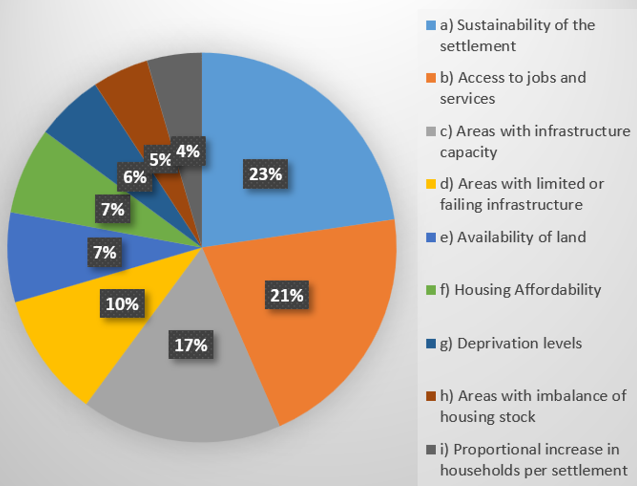
- The types of issues that should inform development locations such as land availability, housing affordability and levels of deprivation.
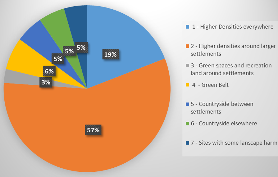
- Site type priority preferences beyond focussing on previously developed land, such as building at high densities, on green spaces, countryside etc.
- The continued use of settlement boundaries and Local Settlement Gaps.
A more detailed overview of the issues raised in response to these questions is available to view in the Consultation Statement available online.
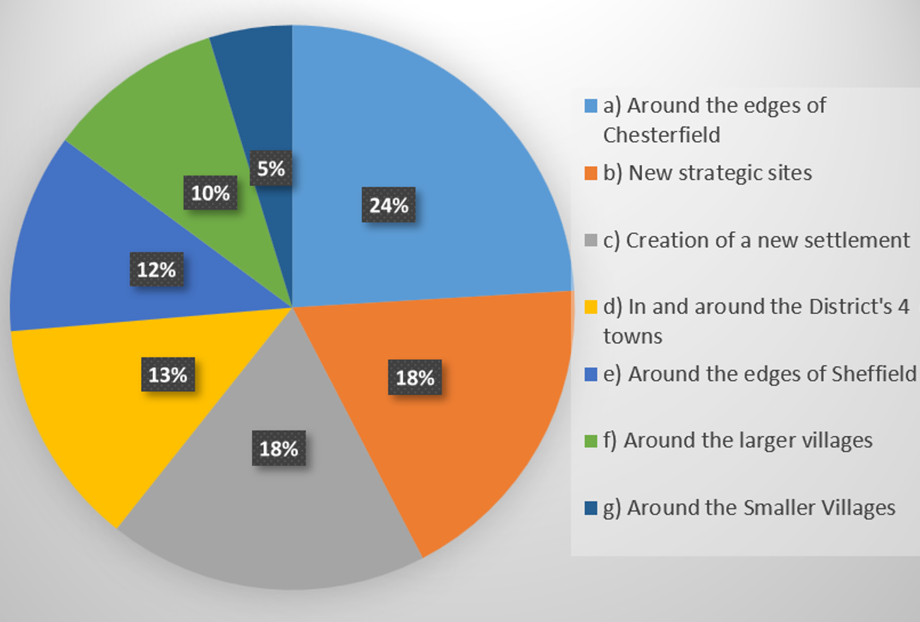
Overall, the consultation responses generally indicate a desire to retain the Green Belt and focus on previously developed land in areas with infrastructure capacity and access to jobs and services. There is widespread support for increasing densities in locations around larger settlements, but a preference for sites on the edges of Chesterfield and Sheffield where capacity is limited and largely within the Green Belt. Conversely there is less support for development around the District’s towns and larger villages where capacity is greatest (albeit a sizeable proportion is within Green Belt or Local Settlement Gaps). Whilst there is also strong support for new strategic sites and/or a new settlement, 50% of the combined capacity of these options is within the Green Belt and would meet less than half of the Standard Method housing target.
The consultation responses broadly correlate with the levels of sustainability identified for the district’s settlements in the Settlement Role and Function Study and which reinforce the strategy approach of the current adopted Local Plan. For example, there is a stronger preference for focussing development around larger urban areas, where levels of sustainability are highest, and lower support for development around small settlements. However, there is also a clear mismatch between the preferred locations for growth and the availability/suitability of land highlighting the difficult decisions that need to be taken by the Council.
You can view the detailed Settlement Role & Function Study online.
Proposed Approach to the Location of Development
The proposed approach to the settlement hierarchy and priority locations for the distribution of development is based upon the evidence set out in the Settlement Role and Function Study and applies the findings of the Issues & Options. The approach broadly mirrors the settlement hierarchy in the adopted Local Plan with the addition of the ‘edges of Chesterfield and Sheffield’ to the highest priority locations.
Figure 7: Approach to the Location of development
|
Priority Level |
Location Types |
|
Priority 1 Locations: |
|
|
Priority 2 Locations: |
|
|
Priority 3 Locations: |
|
|
Priority 4 Locations: |
|
It is intended that site allocations will be assigned using a cascade approach, whereby the higher the position in the hierarchy, the more development is likely to be focussed there. Noting that this does not override Green Belt or other desirable policy restrictions such as Local Settlement Gaps, provided that sufficient suitable sites can be found elsewhere in appropriate locations.
The approach can be justified on the basis that it is appropriate to prioritise development closest to existing services and facilities where there is clear evidence of existing capacity or where the necessary capacity can be provided, such as around the edges of neighbouring urban areas and the districts larger settlements; and through the creation of new settlements and strategic sites.
The broad strategy for development will involve maximising allocations in areas outside of the Green Belt before considering sites within it; and then only where it can be shown to be necessary, i.e. exceptional circumstances can be demonstrated, as required by national policy.
It is also important to recognise that there are large parts of the district, particularly (but not exclusively) in the west, that are not sustainable locations for development. This cannot be a blanket approach i.e. we cannot say ‘there will be no development in the west/north/south at all’, but there are many areas that cannot be the focus for significant development because the services and facilities do not exist to support them and trying to bring that infrastructure forward through development would not be viable. These locations are generally Level 4 settlements (and some Level 3) and it is expected that development in these areas will be restricted in scale, relative to the size of the settlement, and targeted to meet local needs.
Settlement Hierarchy
The Settlement Role and Function Study provides evidence on the relative sustainability of settlements within the district, based on an assessment of levels of population, availability and diversity of services & facilities, employment provision and the availability and frequency of Public Transport.
In the previous consultation we asked whether the new Local Plan should follow the same approach as the current Local plan and identify 4 settlement levels. 86% of respondents indicated a preference for the new Local Plan to identify 4 levels of settlement.14% did not agree with current approach citing issues with the scoring methodology, and concerns about retaining Green Belt and Settlement Gap boundaries, with some suggesting the opportunities for clustering settlements where services and facilities are/ could be, shared.
The Settlement Hierarchy Topic Paper sets out the proposed settlement hierarchy (Figure 8). It takes forward and refines the evidence from the Settlement Role and Function Study to establish bandings for the various settlement levels. It also considers the spatial pattern of settlements, the services and facilities within, and their relation to each other to identify whether the sustainability of some smaller rural settlements would more accurately represented when they are considered collectively, rather than in isolation.
Settlement clusters have been identified in the areas around Shirland, Pilsley and Unstone, areas where groups of settlements demonstrate strong and demonstrable functional relationships, rather than simply geographic proximity. The evidence supporting this is included in the Settlement Hierarchy Topic paper.
It is important to note that a settlement’s position in the hierarchy indicates its theoretical potential to accommodate development. It does not take account of land availability, land suitability, or other policy restrictions, such as the Green Belt and Settlement Gaps. For this reason, it is possible that sites in the upper tiers of the hierarchy are less able to accommodate development than settlements in the lower tier.
You can view the Settlement Hierarchy Topic Paper online.
Figure 8: Proposed Settlement hierarchy
|
Settlement |
Population Score |
Facilities and Services Score |
Employment Score |
Public Transport Score |
Total Score |
|
|
Level 1 Settlements - Main Towns |
Dronfield |
10+ |
10+ |
10+ |
10+ |
40+ |
|
Clay Cross |
10+ |
10+ |
10+ |
10+ |
40+ |
|
|
Killamarsh |
10+ |
10+ |
10 |
10+ |
40+ |
|
|
Eckington |
10+ |
10+ |
8 |
10+ |
38+ |
|
|
Level 2 Settlements - Larger Villages |
Wingerworth |
10 |
8 |
3 |
10 |
31 |
|
North Wingfield |
9 |
10 |
2 |
9 |
30 |
|
|
Holmewood |
6 |
8 |
10 |
6 |
30 |
|
|
Shirland Cluster (Shirland, Higham, Stonebroom & Mickley) |
8 |
9 |
3 |
5 |
25 |
|
|
Tupton |
5 |
9 |
3 |
7 |
24 |
|
|
Calow |
4 |
5 |
1 |
10 |
20 |
|
|
Grassmoor |
6 |
5 |
3 |
4 |
18 |
|
|
Pilsley Cluster (Pilsley & Lower Pilsley) |
6 |
6 |
3 |
3 |
18 |
|
|
Renishaw |
4 |
4 |
2 |
7 |
17 |
|
|
Level 3 Settlements - Smaller Villages |
Marsh Lane |
2 |
2 |
2 |
9 |
15 |
|
Unstone Cluster (Unstone, Unstone Crow Lane, Unstone Green) |
2 |
3 |
1 |
8 |
14 |
|
|
Holymoorside |
2 |
3 |
2 |
6 |
13 |
|
|
Arkwright Town |
1 |
3 |
1 |
7 |
12 |
|
|
Long Duckmanton |
1 |
2 |
1 |
7 |
11 |
|
|
Walton |
1 |
3 |
1 |
5 |
10 |
|
|
Morton |
2 |
4 |
1 |
3 |
10 |
|
|
Winsick |
1 |
4 |
1 |
4 |
10 |
|
|
Wadshelf |
1 |
1 |
1 |
6 |
9 |
|
|
Heath |
1 |
1 |
1 |
6 |
9 |
|
|
Spinkhill |
1 |
2 |
1 |
5 |
9 |
|
|
Stretton |
1 |
2 |
1 |
5 |
9 |
|
|
Ashover |
1 |
3 |
2 |
2 |
9 |
|
|
Temple Normanton |
1 |
2 |
1 |
4 |
8 |
|
|
Kelstedge |
1 |
1 |
1 |
5 |
8 |
|
|
Highmoor |
1 |
1 |
1 |
5 |
8 |
|
|
Wessington |
1 |
2 |
1 |
3 |
7 |
|
|
Ridgeway |
1 |
2 |
1 |
3 |
7 |
|
|
Cutthorpe |
1 |
2 |
2 |
2 |
7 |
|
|
Holmesfield |
1 |
2 |
1 |
3 |
7 |
|
|
Level 4 Settlements – Very Small Villages / Hamlets |
Woolley Moor |
1 |
2 |
1 |
2 |
6 |
|
Brackenfield |
1 |
1 |
1 |
3 |
6 |
|
|
Barlow Village |
1 |
1 |
1 |
3 |
6 |
|
|
Barlow Commonside |
1 |
1 |
1 |
3 |
6 |
|
|
Apperknowle |
1 |
1 |
1 |
3 |
6 |
|
|
Sutton Scarsdale |
1 |
1 |
1 |
2 |
5 |
|
|
Old Brampton |
1 |
1 |
1 |
2 |
5 |
|
|
Littlemoor |
1 |
1 |
1 |
2 |
5 |
|
|
Fallgate |
1 |
0 |
1 |
3 |
5 |
|
|
Handley |
1 |
1 |
1 |
1 |
4 |
|
|
Alton |
1 |
1 |
1 |
0 |
3 |
|
|
Bolehill |
1 |
1 |
1 |
0 |
3 |
|
|
Cock Alley |
1 |
0 |
1 |
0 |
2 |
Sustainability Appraisal (SA)
In drawing up the Local Plan, we must carry out an appraisal of the sustainability of the Plan’s proposals at each stage in the Plan’s development. Sustainability Appraisal is an iterative process and should be used to test policy options as they are explored and refined to understand their effects on a set of indicators for sustainable development. The council must publish the findings of the appraisals and demonstrate how they have influenced the plan’s policies through the process of its preparation.
The Council has appointed consultants to undertake its Sustainability Appraisal, which will provide an external check on our policies, adding to the robustness of the Plan. Firstly, an SA Scoping Report was produced which included an SA Framework to provide a way in which sustainability effects can be described, analysed and compared. Following the Scoping stage, the Regulation 18 SA Issues and Options Report (2025) was prepared to provide a commentary and recommendations on the high-level issues and questions presented in the Issues and Options Consultation document.
The most recent work has involved an appraisal of reasonable alternative sites for potential allocation in the Local Plan, to help inform which sites to take forward and which to exclude from further consideration. This stage of SA has informed the development of the strategic approach to development and the refined schedule of sites in this document and is set out in the Regulation 18: Addendum to the Issues and Options SA (March 2026). Comments are invited on this SA report and will be used to inform the next stages, where appropriate.
Habitats Regulations Assessment (HRA)
The Local Plan must also be subject to Habitats Regulation Assessment to identify any aspects of the Plan that would have the potential to cause a likely significant effect on European Sites of nature conservation importance. The designated sites of European interest in North East Derbyshire are the Peak District Moors Special Protection Area (SPA) and the South Pennine Moors Special Area of Conservation (SAC), albeit they are located outside of the area covered by the Local Plan. Other European sites near to North East Derbyshire, but outside of the administrative boundary, are the Peak District Dales SAC, and the Gang Mine SAC in Derbyshire Dales District.
In June 2025 a HRA was undertaken to inform the Plan process at the Issues and Options consultation stage. This report scoped key issues to identify threats and pressures at European sites. Following this further work has been undertaken to screen the refined list of sites in this document to identify those impact pathways that may give rise to Likely Significant Effects at European sites. The results of this preliminary screening exercise are set out in the Regulation 18: Addendum to the Issues and Options HRA.
Refined Schedule of Sites
Sites that have passed the site assessment process are included below. They are set out in priority order, in line with the proposed approach to the location of development. We invite your comments on the individual sites, and you are also able to comment on the settlements themselves.
A map is included for each settlement, showing the individual sites, and their possible use (housing, employment or gypsy and traveller uses). Where a site is ‘greyed out’ on the map, it is attributed to a different settlement, and can be found on the map for this other settlement. This applies to locations where settlements are in close proximity to another. The settlement map also includes the Settlement Development Limits, Local Settlement Gaps and/or Green Belt, as designated in the current Local Plan (2014 – 2034).
A map is also included for each individual site, showing a red boundary line. The map is accompanied by a summary of the site assessment result. This is based on the Land Availability Assessments (LAA) for Housing, Employment and Gypsy and Travellers.
You are able to view the detailed Land Availability Assessments online.
Housing Land Availability Assessment
Employment Land Availability Assessment
Gypsy and Traveller Land Availability Assessment
The site text indicates an approximate number of houses for residential developments. These are based on an assessment of the prevailing density of adjacent existing residential areas, excluding some land for infrastructure depending on the site size. For more information, please see the Housing Land Availability Assessment.
In addition, for the sites in Priority 1 and Priority 2 locations, we have added a 20% uplift in housing capacity. This is in response to consultation feedback which indicated widespread support for increasing densities in locations around larger settlements (see figure 6 above).
IMPORTANT TO NOTE:
- The refined sites list includes summary information of constraints.
- The list contains sites that still include some constraints and so may not necessarily be included in the draft Local Plan that will be consulted on later this year.
- Capacity information, such as housing numbers, is approximate and can be subject to change when further information becomes available and/or mitigation measures are applied.
- Any assessments results that have found no or minor constraints / impacts have not been included in the summary.
- Full details of the assessment results for all sites (refined sites and those discounted) are available to view in the Land Availability Assessments.
- Sites in the Green Belt are included, pending the outcome of a new Green Belt Review that is being undertaken in line with the latest National Planning Policy Framework (NPPF Dec. 2004) and Planning Practice Guidance (NPPG for Green Belts, Feb 2025). Reference is made to the conclusions of the previous Green Belt Review (2016/17) on relevant sites, but this is for information only. The introduction of Grey Belt in national policy (NPPF page 73); the clarification that villages are not included within the purpose of preventing the merging of settlements; and potential for different approaches for identifying assessment areas are all key changes since the last review that may result in different conclusions in the new Review. For reference purposes the 2016/17 Green Belt Review parcel assessments can be viewed here.
- Not all sites have reached the same stage in the assessment process – some were submitted later, or comments are not yet available.
- More sites may still be submitted, and discounted sites may come back in with further information.
- Further evidence that may be forthcoming from the site promoter and responses to this consultation will inform the Preferred List of Sites that will be included in the Publication Draft Local Plan.